

Offa's Dyke
Encyclopedia
Earthworks (archaeology)
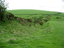
In archaeology, earthwork is a general term to describe artificial changes in land level. Earthworks are often known colloquially as 'lumps and bumps'. Earthworks can themselves be archaeological features or they can show features beneath the surface...
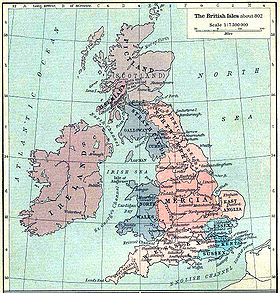
, roughly followed by some of the current border between England
England
England is a country that is part of the United Kingdom. It shares land borders with Scotland to the north and Wales to the west; the Irish Sea is to the north west, the Celtic Sea to the south west, with the North Sea to the east and the English Channel to the south separating it from continental...
and Wales
Wales
Wales is a country that is part of the United Kingdom and the island of Great Britain, bordered by England to its east and the Atlantic Ocean and Irish Sea to its west. It has a population of three million, and a total area of 20,779 km²...
. In places, it is up to 65 feet (19.8 m) wide (including its flanking ditch) and 8 feet (2.4 m) high. In the 8th century it formed some kind of delineation between the Anglian
Anglian
Anglian may refer to* The Anglian dialects* The Anglic languages* The Anglian Stage * The Anglian automobile* Used in reference to the cultural products and politics of the Angles of Anglo-Saxon England...
kingdom of Mercia
Mercia
Mercia was one of the kingdoms of the Anglo-Saxon Heptarchy. It was centred on the valley of the River Trent and its tributaries in the region now known as the English Midlands...
and the Welsh kingdom of Powys. Research in recent decades has dispelled many of the earlier theories and ideas about the earthwork.
Overview
Offa of Mercia
Offa was the King of Mercia from 757 until his death in July 796. The son of Thingfrith and a descendant of Eowa, Offa came to the throne after a period of civil war following the assassination of Æthelbald after defeating the other claimant Beornred. In the early years of Offa's reign it is likely...
, King of Mercia from 757 to 796. Its structure is not that of a mutual boundary between the Mercians on the one side and the people of Powys on the other. The earthwork was dug with the displaced soil piled into a bank on the Mercian (eastern) side. Where the earthwork encounters hills, it passes to the west of them, constantly providing an open view from Mercia into Wales. The dyke may have been constructed as a defensive earthwork, as well as a political statement of power and intent.
Offa
Offa of Mercia
Offa was the King of Mercia from 757 until his death in July 796. The son of Thingfrith and a descendant of Eowa, Offa came to the throne after a period of civil war following the assassination of Æthelbald after defeating the other claimant Beornred. In the early years of Offa's reign it is likely...
was one of the great rulers of Anglo-Saxon times, though his reign is often overlooked due to a limitation in source material. That he was able to raise a workforce and resources sufficient enough to construct such an earthwork as Offa's Dyke is testament to his power. It is likely that some form of 'service' system along the lines of corvée
Corvée
Corvée is unfree labour, often unpaid, that is required of people of lower social standing and imposed on them by the state or a superior . The corvée was the earliest and most widespread form of taxation, which can be traced back to the beginning of civilization...
was used to construct the Dyke, with people from certain areas being required to build a certain length of the wall. This can be seen as additional to the normal services that had to be offered to kings. A document exists from around this period known as Tribal Hidage
Tribal Hidage
Image:Tribal Hidage 2.svg|thumb|400px|alt=insert description of map here|The tribes of the Tribal Hidage. Where an appropriate article exists, it can be found by clicking on the name.rect 275 75 375 100 Elmetrect 375 100 450 150 Hatfield Chase...
, which makes some assessment of how land was distributed in the 8th century. Though there is little evidence to associate the document with the Dyke, it is possible that both the Dyke and the document stem from a common practice.
Historical evidence
The late 9th- and early 10th-century writer AsserAsser
Asser was a Welsh monk from St David's, Dyfed, who became Bishop of Sherborne in the 890s. About 885 he was asked by Alfred the Great to leave St David's and join the circle of learned men whom Alfred was recruiting for his court...
informed us that "there was in Mercia in fairly recent time a certain vigorous king called Offa, who terrified all the neighbouring kings and provinces around him, and who had a great dyke built between Wales and Mercia from sea to sea" (Asser, Life of Alfred, p. .14). The last four words are vital: historians and archaeologists coming to the Dyke have had Asser in their hand, and have been looking for an earthwork 'from sea to sea'. Sir Cyril Fox completed the first major survey of the Dyke (Fox 1955), and, in agreement with Asser, theorized that the Dyke ran from the estuary
Estuary
An estuary is a partly enclosed coastal body of water with one or more rivers or streams flowing into it, and with a free connection to the open sea....
of the River Dee
River Dee, Wales
The River Dee is a long river in the United Kingdom. It travels through Wales and England and also forms part of the border between the two countries....
in the north to the River Wye
River Wye
The River Wye is the fifth-longest river in the UK and for parts of its length forms part of the border between England and Wales. It is important for nature conservation and recreation.-Description:...
in the south (approximately 150 miles, or 240 km). He observed that the dyke was not continuous, and thought it was built only in areas where natural barriers did not already exist.
Frank Stenton
Frank Stenton
Sir Frank Merry Stenton was a 20th century historian of Anglo-Saxon England, and president of the Royal Historical Society . He was the author of Anglo-Saxon England, a volume of the Oxford History of England, first published in 1943 and widely considered a classic history of the period...
, the eminent Anglo-Saxon
Anglo-Saxons
Anglo-Saxon is a term used by historians to designate the Germanic tribes who invaded and settled the south and east of Great Britain beginning in the early 5th century AD, and the period from their creation of the English nation to the Norman conquest. The Anglo-Saxon Era denotes the period of...
historian of his day, accepted Fox's description, and wrote the introduction to Fox's account of the Dyke. Though Fox's work has now been to some extent revised, it remains a vital record of stretches of the Dyke that still existed between 1926 and 1928, when his three field surveys took place, but that are now destroyed.
Modern scholarship
Frank Noble challenged Fox's legacy. His greatest contribution was to stir up new academic interest in Offa's Dyke. His MPhil thesisThesis
A dissertation or thesis is a document submitted in support of candidature for an academic degree or professional qualification presenting the author's research and findings...
, "Offa's Dyke Reviewed" (1978), raised several questions. Noble postulated that the gaps in the Dyke were not due to natural features, but that instead a "ridden boundary" operated, perhaps incorporating palisade
Palisade
A palisade is a steel or wooden fence or wall of variable height, usually used as a defensive structure.- Typical construction :Typical construction consisted of small or mid sized tree trunks aligned vertically, with no spacing in between. The trunks were sharpened or pointed at the top, and were...
s that left no archaeological trace. Noble also helped establish the Offa's Dyke Association, which maintains the Offa's Dyke Path
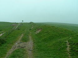
Offa's Dyke Path
Offa's Dyke Path is a long distance footpath along the Welsh-English border. Opened in 1971, it is one of Britain's premier National Trails and draws walkers from throughout the world...
. This long distance footpath mostly follows the route of the dyke, which is one of the designated British National Trails.
Ongoing research and archaeology on Offa's Dyke has been undertaken for many years by the Extra-Mural department of the University of Manchester
University of Manchester
The University of Manchester is a public research university located in Manchester, United Kingdom. It is a "red brick" university and a member of the Russell Group of research-intensive British universities and the N8 Group...
. Most recently David Hill and Margaret Worthington have undertaken considerable research on the Dyke. Their work, though far from finished, has demonstrated that there is little evidence for the Dyke's stretching from sea to sea. Rather, they claim that it is a shorter structure stretching from Rushock Hill north of the Herefordshire
Herefordshire
Herefordshire is a historic and ceremonial county in the West Midlands region of England. For Eurostat purposes it is a NUTS 3 region and is one of three counties that comprise the "Herefordshire, Worcestershire and Gloucestershire" NUTS 2 region. It also forms a unitary district known as the...
Plain to Llanfynydd
Llanfynydd, Flintshire
Llanfynydd is a village and local government community in Flintshire, north Wales. Its name is derived from the Welsh words llan, "church" or "parish", and mynydd, "mountain"....
, near Mold, Flintshire
Mold, Flintshire
Mold is a town in Flintshire, North Wales, on the River Alyn. It is the administrative seat of Flintshire County Council, and was also the county town of Clwyd from 1974 to 1996...
, some 64 miles (103 km). According to Hill and Worthington, dykes in the far north and south may have different dates, and though they may be connected with Offa's Dyke, there is as yet no compelling evidence behind this. However, not all experts accept this view.
Alternative theories
The Roman historian Eutropius in his book, Historiae Romanae Breviarium, written around 369, mentions the Wall of SeverusWall of Severus
Wall of Severus, built by Septimius Severus : He had his last war in Britain, and to fortify the conquered provinces with all security, he built a wall for 132 miles from sea to sea...
, a structure built by Septimius Severus
Septimius Severus
Septimius Severus , also known as Severus, was Roman Emperor from 193 to 211. Severus was born in Leptis Magna in the province of Africa. As a young man he advanced through the customary succession of offices under the reigns of Marcus Aurelius and Commodus. Severus seized power after the death of...
who was Roman Emperor
Roman Emperor
The Roman emperor was the ruler of the Roman State during the imperial period . The Romans had no single term for the office although at any given time, a given title was associated with the emperor...
between 193 and 211:
Novissimum bellum in Britannia habuit, utque receptas provincias omni securitate muniret, vallum per CXXXIII passuum milia a mari ad mare deduxit. Decessit Eboraci admodum senex, imperii anno sexto decimo, mense tertio. Historiae Romanae Breviarium, viii 19.1
He had his most recent war in Britain, and to fortify the conquered provinces with all security, he built a wall for 133 miles from sea to sea. He died at York, a reasonably old man, in the sixteenth year and third month of his reign.
This source is conventionally thought to be referring, in error, to either Hadrian's Wall
Hadrian's Wall
Hadrian's Wall was a defensive fortification in Roman Britain. Begun in AD 122, during the rule of emperor Hadrian, it was the first of two fortifications built across Great Britain, the second being the Antonine Wall, lesser known of the two because its physical remains are less evident today.The...
(73 miles (117.5 km)) or the Antonine Wall
Antonine Wall
The Antonine Wall is a stone and turf fortification built by the Romans across what is now the Central Belt of Scotland, between the Firth of Forth and the Firth of Clyde. Representing the northernmost frontier barrier of the Roman Empire, it spanned approximately 39 miles and was about ten feet ...
(37 miles (59.5 km)), which were both much shorter and built in the 2nd century. Recently, some writers have suggested that Eutropius may have been referring to the earthwork later called Offa's Dyke. Most archaeologists reject this theory.
Recent evidence has been found that strengthens the theory of an earlier date for the wall's construction. In December 1999 Shropshire County Council archaeologists uncovered the remains of a hearth or fire on the original ground surface beneath the raised bank of the ancient Wat's Dyke
Wat's Dyke
Wat's Dyke is a 40 mile earthwork running through the northern Welsh Marches from Basingwerk Abbey on the River Dee estuary, passing to the east of Oswestry and onto Maesbury in Shropshire, England...
near Oswestry
Oswestry
Oswestry is a town and civil parish in Shropshire, England, close to the Welsh border. It is at the junction of the A5, A483, and A495 roads....
, England. Carbon dating analysis of the burnt charcoal and burnt clay in situ showed it was covered by earth on or around AD 446. Archaeologists concluded that this part of Wat's Dyke, so long thought of as Anglo-Saxon and a mid-8th century contemporary of Offa's Dyke, must have been built 300 years earlier in the post-Roman period in Britain.
The Offa's Dyke Centre
The Offa's Dyke Centre is a purpose-built information centre in the town of Knighton, situated on Offa's Dyke on the border between England (ShropshireShropshire
Shropshire is a county in the West Midlands region of England. For Eurostat purposes, the county is a NUTS 3 region and is one of four counties or unitary districts that comprise the "Shropshire and Staffordshire" NUTS 2 region. It borders Wales to the west...
) and Wales
Wales
Wales is a country that is part of the United Kingdom and the island of Great Britain, bordered by England to its east and the Atlantic Ocean and Irish Sea to its west. It has a population of three million, and a total area of 20,779 km²...
(Powys
Powys
Powys is a local-government county and preserved county in Wales.-Geography:Powys covers the historic counties of Montgomeryshire and Radnorshire, most of Brecknockshire , and a small part of Denbighshire — an area of 5,179 km², making it the largest county in Wales by land area.It is...
). Some of the best remains of the earthworks can be seen within a two-minute walk from the centre. There is also a visitor centre at the northernmost point of the walkway in Prestatyn
Prestatyn
Prestatyn is a seaside resort, town and community in Denbighshire, North Wales. It is located on the Irish Sea coast, to the east of Rhyl. At the 2001 Census, Prestatyn had a population of 18,496.-Prehistory:...
on the North Wales coast.
Cultural references
The Dyke has in some cases been brought into common folklore, though this should not be seen as historical evidence for the purpose behind the Dyke.Today, the England-Wales border still mostly follows the dyke through the Welsh Marches
Welsh Marches
The Welsh Marches is a term which, in modern usage, denotes an imprecisely defined area along and around the border between England and Wales in the United Kingdom. The precise meaning of the term has varied at different periods...
. It has a cultural significance, symbolising the separation between the two, similar to the symbolism of Hadrian's Wall
Hadrian's Wall
Hadrian's Wall was a defensive fortification in Roman Britain. Begun in AD 122, during the rule of emperor Hadrian, it was the first of two fortifications built across Great Britain, the second being the Antonine Wall, lesser known of the two because its physical remains are less evident today.The...
between England and Scotland
Scotland
Scotland is a country that is part of the United Kingdom. Occupying the northern third of the island of Great Britain, it shares a border with England to the south and is bounded by the North Sea to the east, the Atlantic Ocean to the north and west, and the North Channel and Irish Sea to the...
in the Scottish Marches
Scottish Marches
Scottish Marches was the term used for the Anglo-Scottish border during the late medieval and early modern eras—from the late 13th century, with the creation by Edward I of England of the first Lord Warden of the Marches to the early 17th century and the creation of the Middle Shires, promulgated...
.
A three-mile section of the dyke, which overlooks Tintern Abbey
Tintern Abbey
Tintern Abbey was founded by Walter de Clare, Lord of Chepstow, on 9 May 1131. It is situated in the village of Tintern, on the Welsh bank of the River Wye in Monmouthshire, which forms the border between Monmouthshire in Wales and Gloucestershire in England. It was only the second Cistercian...
and includes the Devil's Pulpit near Chepstow, is now in the care of English Heritage
English Heritage
English Heritage . is an executive non-departmental public body of the British Government sponsored by the Department for Culture, Media and Sport...
.
See also
- Offa's Dyke PathOffa's Dyke PathOffa's Dyke Path is a long distance footpath along the Welsh-English border. Opened in 1971, it is one of Britain's premier National Trails and draws walkers from throughout the world...
- England and WalesEngland and WalesEngland and Wales is a jurisdiction within the United Kingdom. It consists of England and Wales, two of the four countries of the United Kingdom...
- Wales-England border
- Wat's DykeWat's DykeWat's Dyke is a 40 mile earthwork running through the northern Welsh Marches from Basingwerk Abbey on the River Dee estuary, passing to the east of Oswestry and onto Maesbury in Shropshire, England...
- Scots' DikeScots' DikeThe Scots' Dike or dyke is a three and a half mile / 5.25 km long linear earthwork, constructed by the English and the Scots in the year 1552 to mark the division of the Debatable lands and thereby settle the exact boundary between the Kingdoms of Scotland and England.-Introduction:The...
- GötavirkeGötavirkeGötavirke are the remains of two parallel defensive walls going from north to south between the villages of Västra Husby and Hylinge in Östergötland, Sweden. The walls cover the distance between the lakes Asplången and Lillsjön . North of Asplången there are remains of several ancient hill...
(GeatGeatGeats , and sometimes Goths) were a North Germanic tribe inhabiting what is now Götaland in modern Sweden...
ish Dyke) - DanevirkeDanevirkeThe Danevirke The Danevirke The Danevirke (modern Danish spelling: Dannevirke; in Old Norse Danavirki ; in German Danewerk ; is a system of Danish fortifications in Schleswig-Holstein (Northern Germany). This important linear defensive earthwork was constructed across the neck of the Cimbrian...
(Danish Dyke) - WansdykeWansdyke (earthwork)Wansdyke is a series of early medieval defensive linear earthworks in the West Country of England, consisting of a ditch and a running embankment from the ditch spoil, with the ditching facing north. It runs at least from Maes Knoll in historic Somerset, a hillfort at the east end of Dundry Hill...
- Separation barrierSeparation barrierA separation barrier is a wall or fence constructed to limit the movement of people across a certain line or border, or to separate two populations. These structures vary in placement with regard to international borders and topography...
- Silesia WallsSilesia WallsSilesia Walls are a line of three parallel earthen ramparts and ditches that run through Lower Silesia in Poland, by the towns Szprotawa and Kożuchów. The walls are about 2.5 metres tall and, at their widest, 47 metres. They run for about 30 kilometres...
External links
- Offa's Dyke Association website
- Ramblers' Association: Offa's Dyke Path National Trail
- Clwyd-Powys Archaeological Trust: Introducing Offa's Dyke
- How Offa's Dyke created a genetic barrier between the English and the Welsh BBC Gene Stories article
- Walking Offa's Dyke Path
- Off On An Offa's Dyke Hike - A Tale of Two Brothers
- History and research Offa's Dyke; English Heritage