
October 1998 Central Texas floods
Encyclopedia
The October 1998 Texas Flooding was a flood
event that occurred across parts of South Texas
and Southeast Texas
on the weekend of October 17 and October 18, 1998. The storm that caused it was one of the costliest in the recorded meteorological history of the United States, bringing rainfall of over 20 inches (508 mm) to some parts of Southeast Texas and causing over $ 750 million in damages. 31 people were killed as a result of the storm, mostly from drowning
.
approached from the Western United States
and collided with very warm, moist air which had been sitting over Southern Texas for the past few days. This caused dew point
s in the area to be in the mid 70s that weekend. Also, an area of very warm and moist air was present nearby due to Hurricane Madeline
, which was sitting off the west coast of Mexico. On October 16, the storm was being forecast by the National Weather Service
to produce a significant amount of rain, and was only missing one ingredient for it to be a disastrous storm. The missing ingredient was a cold front, and one was moving steadily across the Western United States. Forecasters predicted that if this were to arrive at the same time as the rain, there would be heavy rain and possibly flooding. At 3:30 AM Central Standard Time, the National Weather Service in New Braunfels, Texas
issued a flash flood
watch for all counties in South, South-Central, and Southeast Texas.
Between the hours of midnight and 4 A.M. on October 17, 1998, small clusters of rain showers and thunderstorms began to form over Southern Texas very far ahead of the approaching cold front
. For the next few hours, storms did not organize much into powerful clusters until the convection formed over the northern part of Bexar County, Texas
, which included the city of San Antonio
. After this formation, the storms rapidly increased in formation and power until the cold front arrived. The convection
spread very quickly into other counties after this intensification. These counties included Travis
, which included the city of Austin, Texas
. The cold front would soon arrive to the area, bringing torrential rains.
 The cold front arrived in Southern and Southeastern Texas on the evening of Saturday, October 17 1998. This caused the storm to rapidly intensify until the torrential downpours began over the entire area. This started to flood many rivers and other bodies of water in the area, including the San Marcos River
, the Guadalupe River
, Canyon Lake
, and the Medina River
. The rainfall caused widespread flash flooding across the urban area of San Antonio and the city of Austin. Heavy rains continued for the entire day of October 18, 1998, and eventually tapered off and moved away to the coast and soon offshore. It caused major flooding in seven different river basins, and drained nearly 10000 square miles (25,899.9 km²). The rain caused record rain totals in fifteen bodies of water, as recorded by the United States Geological Survey
.
and South
-Central Texas, and there was minor flooding along the coast of the state.
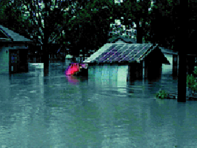 The greatest impact was in Southern Texas, which included the urban areas of San Antonio and Austin
, and all of their surrounding suburbs. The counties with the most significant rainfall, damage, and fatalities were Travis County Bexar County, Guadalupe County
, and Caldwell County
. This area included both the cities of San Antonio and Austin
. In a small area in Caldwell County, there was 29 inches (736.6 mm) of rain estimated by the United States Geological Survey
. This included the area of Lockhart, Texas
, which was badly flooded by the storm due to its close proximity to the San Marcos River
. Most of the county picked up an estimated 20-30 inches of rain, including San Marcos, Texas
, New Braunfels, Texas
, and Kyle, Texas
.
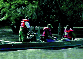
. Of the deaths caused by drowning, 22 of them were caused by a driver driving their vehicle into high water on a road
flooded by the torrential downpours. There were 16 different incidents when these types of deaths occurred, four of them involving in multiple deaths. 63% of these incidents involved a truck
, van
, or sport utility vehicle
. Other deaths included three cardiac arrest
s, three incidents of multiple trauma
, and one death caused by hypothermia
after being submerged in the water.
Flood
A flood is an overflow of an expanse of water that submerges land. The EU Floods directive defines a flood as a temporary covering by water of land not normally covered by water...
event that occurred across parts of South Texas
South Texas
South Texas is a region of the U.S. state of Texas that lies roughly south of and including San Antonio. The southern and western boundary is the Rio Grande River, and to the east it is the Gulf of Mexico. The population of this region is about 3.7 million. The southern portion of this region is...
and Southeast Texas
Southeast Texas
Southeast Texas is a subregion of East Texas located in the southeast corner of the U.S. state of Texas. The subregion is geographically centered around the Houston–Sugar Land–Baytown and Beaumont–Port Arthur metropolitan areas...
on the weekend of October 17 and October 18, 1998. The storm that caused it was one of the costliest in the recorded meteorological history of the United States, bringing rainfall of over 20 inches (508 mm) to some parts of Southeast Texas and causing over $ 750 million in damages. 31 people were killed as a result of the storm, mostly from drowning
Drowning
Drowning is death from asphyxia due to suffocation caused by water entering the lungs and preventing the absorption of oxygen leading to cerebral hypoxia....
.
Meteorological synopsis
The storm was created when a very strong upper-level troughTrough (meteorology)
A trough is an elongated region of relatively low atmospheric pressure, often associated with fronts.Unlike fronts, there is not a universal symbol for a trough on a weather chart. The weather charts in some countries or regions mark troughs by a line. In the United States, a trough may be marked...
approached from the Western United States
Western United States
.The Western United States, commonly referred to as the American West or simply "the West," traditionally refers to the region comprising the westernmost states of the United States. Because the U.S. expanded westward after its founding, the meaning of the West has evolved over time...
and collided with very warm, moist air which had been sitting over Southern Texas for the past few days. This caused dew point
Dew point
The dew point is the temperature to which a given parcel of humid air must be cooled, at constant barometric pressure, for water vapor to condense into liquid water. The condensed water is called dew when it forms on a solid surface. The dew point is a saturation temperature.The dew point is...
s in the area to be in the mid 70s that weekend. Also, an area of very warm and moist air was present nearby due to Hurricane Madeline
Hurricane Madeline (1998)
Hurricane Madeline was the final tropical cyclone of the 1998 Pacific hurricane season. Madeline originated from a tropical wave that emerged off the coast of Africa on September 25, 1998. The wave traversed the Atlantic Ocean and crossed over Central America on October 5 or 6...
, which was sitting off the west coast of Mexico. On October 16, the storm was being forecast by the National Weather Service
National Weather Service
The National Weather Service , once known as the Weather Bureau, is one of the six scientific agencies that make up the National Oceanic and Atmospheric Administration of the United States government...
to produce a significant amount of rain, and was only missing one ingredient for it to be a disastrous storm. The missing ingredient was a cold front, and one was moving steadily across the Western United States. Forecasters predicted that if this were to arrive at the same time as the rain, there would be heavy rain and possibly flooding. At 3:30 AM Central Standard Time, the National Weather Service in New Braunfels, Texas
New Braunfels, Texas
New Braunfels is a city in Comal and Guadalupe counties in the U.S. state of Texas that is a principal city of the metropolitan area. Braunfels means "brown rock" in German; the city is named for Braunfels, in Germany. The city's population was 57,740 as of the 2010 census, up 58% from the 2000...
issued a flash flood
Flash flood
A flash flood is a rapid flooding of geomorphic low-lying areas—washes, rivers, dry lakes and basins. It may be caused by heavy rain associated with a storm, hurricane, or tropical storm or meltwater from ice or snow flowing over ice sheets or snowfields...
watch for all counties in South, South-Central, and Southeast Texas.
Between the hours of midnight and 4 A.M. on October 17, 1998, small clusters of rain showers and thunderstorms began to form over Southern Texas very far ahead of the approaching cold front
Cold front
A cold front is defined as the leading edge of a cooler mass of air, replacing a warmer mass of air.-Development of cold front:The cooler and denser air wedges under the less-dense warmer air, lifting it...
. For the next few hours, storms did not organize much into powerful clusters until the convection formed over the northern part of Bexar County, Texas
Bexar County, Texas
As of the census of 2000, there were 1,392,931 people, 488,942 households, and 345,681 families residing in the county. The population density was 1,117 people per square mile . There were 521,359 housing units at an average density of 418 per square mile...
, which included the city of San Antonio
San Antonio, Texas
San Antonio is the seventh-largest city in the United States of America and the second-largest city within the state of Texas, with a population of 1.33 million. Located in the American Southwest and the south–central part of Texas, the city serves as the seat of Bexar County. In 2011,...
. After this formation, the storms rapidly increased in formation and power until the cold front arrived. The convection
Convection
Convection is the movement of molecules within fluids and rheids. It cannot take place in solids, since neither bulk current flows nor significant diffusion can take place in solids....
spread very quickly into other counties after this intensification. These counties included Travis
Travis County, Texas
As of 2009, the U.S. census estimates there were 1,026,158 people, 320,766 households, and 183,798 families residing in the county. The population density was 821 people per square mile . There were 335,881 housing units at an average density of 340 per square mile...
, which included the city of Austin, Texas
Austin, Texas
Austin is the capital city of the U.S. state of :Texas and the seat of Travis County. Located in Central Texas on the eastern edge of the American Southwest, it is the fourth-largest city in Texas and the 14th most populous city in the United States. It was the third-fastest-growing large city in...
. The cold front would soon arrive to the area, bringing torrential rains.
San Marcos River
The San Marcos River rises from the San Marcos Springs, the location of Aquarena Springs, in San Marcos, Texas. The springs are home to several threatened or endangered species, including the Texas Blind Salamander, Fountain Darter, and Texas Wild Rice...
, the Guadalupe River
Guadalupe River (Texas)
The Guadalupe River runs from Kerr County, Texas to San Antonio Bay on the Gulf of Mexico. The river is a popular destination for rafters and canoers. Larger cities along the river include New Braunfels, Kerrville, Seguin, Gonzales, Cuero, and Victoria...
, Canyon Lake
Canyon Lake (Texas)
Canyon Lake is a reservoir on the Guadalupe River in the Texas Hill Country in the United States. Canyon Lake is a U.S. Army Corps of Engineers reservoir formed on the Guadalupe River in Comal County by Canyon Dam, which is located about sixteen miles northwest of New Braunfels. The dam, lake,...
, and the Medina River
Medina River
The Medina River is located in south central Texas, USA, in the Medina Valley. Named after Pedro Medina, a Spanish engineer, by Alonso de León, Spanish governor of Coahuila, New Spain in 1689. It was also known as the Rio Mariano, Rio San Jose, or Rio de Bagres...
. The rainfall caused widespread flash flooding across the urban area of San Antonio and the city of Austin. Heavy rains continued for the entire day of October 18, 1998, and eventually tapered off and moved away to the coast and soon offshore. It caused major flooding in seven different river basins, and drained nearly 10000 square miles (25,899.9 km²). The rain caused record rain totals in fifteen bodies of water, as recorded by the United States Geological Survey
United States Geological Survey
The United States Geological Survey is a scientific agency of the United States government. The scientists of the USGS study the landscape of the United States, its natural resources, and the natural hazards that threaten it. The organization has four major science disciplines, concerning biology,...
.
Impact
The flood event impacted many areas, mostly in Southern Texas. Also affected were Southeast TexasSoutheast Texas
Southeast Texas is a subregion of East Texas located in the southeast corner of the U.S. state of Texas. The subregion is geographically centered around the Houston–Sugar Land–Baytown and Beaumont–Port Arthur metropolitan areas...
and South
South
South is a noun, adjective, or adverb indicating direction or geography.South is one of the four cardinal directions or compass points. It is the opposite of north and is perpendicular to east and west.By convention, the bottom side of a map is south....
-Central Texas, and there was minor flooding along the coast of the state.
Central Texas
Austin, Texas
Austin is the capital city of the U.S. state of :Texas and the seat of Travis County. Located in Central Texas on the eastern edge of the American Southwest, it is the fourth-largest city in Texas and the 14th most populous city in the United States. It was the third-fastest-growing large city in...
, and all of their surrounding suburbs. The counties with the most significant rainfall, damage, and fatalities were Travis County Bexar County, Guadalupe County
Guadalupe County, Texas
Guadalupe County is a county located in the U.S. state of Texas. In 2000, its population was 89,023. It is named for the Guadalupe River. The seat of the county is Seguin. It was founded in 1846....
, and Caldwell County
Caldwell County, Texas
Caldwell County is a county located in the U.S. state of Texas. It is part of the Austin-Round Rock metropolitan area. In 2000, the population was 32,194. Its county seat is Lockhart...
. This area included both the cities of San Antonio and Austin
Austin, Texas
Austin is the capital city of the U.S. state of :Texas and the seat of Travis County. Located in Central Texas on the eastern edge of the American Southwest, it is the fourth-largest city in Texas and the 14th most populous city in the United States. It was the third-fastest-growing large city in...
. In a small area in Caldwell County, there was 29 inches (736.6 mm) of rain estimated by the United States Geological Survey
United States Geological Survey
The United States Geological Survey is a scientific agency of the United States government. The scientists of the USGS study the landscape of the United States, its natural resources, and the natural hazards that threaten it. The organization has four major science disciplines, concerning biology,...
. This included the area of Lockhart, Texas
Lockhart, Texas
-External links:* *...
, which was badly flooded by the storm due to its close proximity to the San Marcos River
San Marcos River
The San Marcos River rises from the San Marcos Springs, the location of Aquarena Springs, in San Marcos, Texas. The springs are home to several threatened or endangered species, including the Texas Blind Salamander, Fountain Darter, and Texas Wild Rice...
. Most of the county picked up an estimated 20-30 inches of rain, including San Marcos, Texas
San Marcos, Texas
San Marcos is a city in the U.S. state of Texas, and is the seat of Hays County. Located within the metropolitan area, the city is located on the Interstate 35 corridor—between Austin and San Antonio....
, New Braunfels, Texas
New Braunfels, Texas
New Braunfels is a city in Comal and Guadalupe counties in the U.S. state of Texas that is a principal city of the metropolitan area. Braunfels means "brown rock" in German; the city is named for Braunfels, in Germany. The city's population was 57,740 as of the 2010 census, up 58% from the 2000...
, and Kyle, Texas
Kyle, Texas
Kyle is a town in Hays County, Texas, United States. The population was 5,314 at the 2000 census; it was 26,103 in the 2008 census estimate, making Kyle one of the fastest growing cities in Texas.-Geography:...
.
Flooding data
Source:| Water body | Location | Peak water height (feet) | Notes |
|---|---|---|---|
| Cypress Creek | Hockley, Texas Hockley, Texas Hockley, Texas is an unincorporated community located in Harris County, Texas, United States along on Texas State Highway 6, approximately five miles southeast of the city hall of Waller, and thirty-six miles northwest of Downtown Houston.... |
63.51 | Highest creek stage since 1960. |
| Onion Creek | Driftwood, Texas Driftwood, Texas Driftwood is an unincorporated community in northern Hays County, Texas, United States. It lies along FM 967 north of the city of San Marcos, the county seat of Hays County. Its elevation is 1,043 feet... |
24.91 | Highest creek stage since records began. |
| Sandy Creek | Louise, Texas Louise, Texas Louise is a census-designated place in Wharton County, Texas, United States. The population was 977 as of the 2000 census.-Geography:Louise is located at .... |
24.91 | Highest creek stage since records began. |
| Plum Creek | Louise, Texas Louise, Texas Louise is a census-designated place in Wharton County, Texas, United States. The population was 977 as of the 2000 census.-Geography:Louise is located at .... |
32.70 | Highest Creek stage since records began in 1915. |
| Guadalupe River Guadalupe River (Texas) The Guadalupe River runs from Kerr County, Texas to San Antonio Bay on the Gulf of Mexico. The river is a popular destination for rafters and canoers. Larger cities along the river include New Braunfels, Kerrville, Seguin, Gonzales, Cuero, and Victoria... |
New Braunfels, Texas New Braunfels, Texas New Braunfels is a city in Comal and Guadalupe counties in the U.S. state of Texas that is a principal city of the metropolitan area. Braunfels means "brown rock" in German; the city is named for Braunfels, in Germany. The city's population was 57,740 as of the 2010 census, up 58% from the 2000... |
35.08 | |
| Guadalupe River Guadalupe River (Texas) The Guadalupe River runs from Kerr County, Texas to San Antonio Bay on the Gulf of Mexico. The river is a popular destination for rafters and canoers. Larger cities along the river include New Braunfels, Kerrville, Seguin, Gonzales, Cuero, and Victoria... |
Gonzales, Texas Gonzales, Texas Gonzales is a city in Gonzales County, Texas, United States. The population was 7,202 at the 2000 census. It is the county seat of Gonzales County.-Geography:Gonzales is located at... |
50.44 | Highest river stage since records began in 1905. |
| Guadalupe River Guadalupe River (Texas) The Guadalupe River runs from Kerr County, Texas to San Antonio Bay on the Gulf of Mexico. The river is a popular destination for rafters and canoers. Larger cities along the river include New Braunfels, Kerrville, Seguin, Gonzales, Cuero, and Victoria... |
Cuero, Texas Cuero, Texas Cuero is a city in DeWitt County, Texas, United States. The population was 6,571 at the 2000 census. It is the county seat of DeWitt County. It is also unofficially known as the "turkey capital of the world"... |
49.80 | Highest river stage since records began before 1900. |
| Guadalupe River Guadalupe River (Texas) The Guadalupe River runs from Kerr County, Texas to San Antonio Bay on the Gulf of Mexico. The river is a popular destination for rafters and canoers. Larger cities along the river include New Braunfels, Kerrville, Seguin, Gonzales, Cuero, and Victoria... |
Victoria, Texas Victoria, Texas Victoria is a city in and the seat of Victoria County, Texas, United States. The population was 60,603 at the 2000 census. The three counties of the Victoria Metropolitan Statistical Area had a population of 111,163 at the 2000 census,... |
49.80 | Highest river stage since records began before 1840. |
| San Antonio River San Antonio River The San Antonio River is a major waterway that originates in central Texas in a cluster of springs in north central San Antonio, approximately four miles north of downtown, and follows a roughly southeastern path through the state. It eventually feeds into the Guadalupe River about ten miles from... |
San Antonio, Texas San Antonio, Texas San Antonio is the seventh-largest city in the United States of America and the second-largest city within the state of Texas, with a population of 1.33 million. Located in the American Southwest and the south–central part of Texas, the city serves as the seat of Bexar County. In 2011,... |
12.43 | Highest river stage since records began. |
| San Antonio River (Loop 410) San Antonio River The San Antonio River is a major waterway that originates in central Texas in a cluster of springs in north central San Antonio, approximately four miles north of downtown, and follows a roughly southeastern path through the state. It eventually feeds into the Guadalupe River about ten miles from... |
San Antonio, Texas San Antonio, Texas San Antonio is the seventh-largest city in the United States of America and the second-largest city within the state of Texas, with a population of 1.33 million. Located in the American Southwest and the south–central part of Texas, the city serves as the seat of Bexar County. In 2011,... |
36.15 | Highest river stage since records began. |
| Salado Creek Salado Creek Salado Creek is a waterway in San Antonio that runs from Northern Bexar County for about to the San Antonio River near Buena Vista.-Watershed:... |
San Antonio, Texas San Antonio, Texas San Antonio is the seventh-largest city in the United States of America and the second-largest city within the state of Texas, with a population of 1.33 million. Located in the American Southwest and the south–central part of Texas, the city serves as the seat of Bexar County. In 2011,... |
23.00 | Highest creek stage since records began. |
| Leon Creek | San Antonio, Texas San Antonio, Texas San Antonio is the seventh-largest city in the United States of America and the second-largest city within the state of Texas, with a population of 1.33 million. Located in the American Southwest and the south–central part of Texas, the city serves as the seat of Bexar County. In 2011,... |
28.52 | Highest creek stage since records began. |
| San Antonio River San Antonio River The San Antonio River is a major waterway that originates in central Texas in a cluster of springs in north central San Antonio, approximately four miles north of downtown, and follows a roughly southeastern path through the state. It eventually feeds into the Guadalupe River about ten miles from... |
Elmendorf, Texas Elmendorf, Texas Elmendorf is a city in Bexar County, Texas, United States. It is part of the San Antonio—New Braunfels Metropolitan Statistical Area. The population was 664 at the 2000 census. Elmendorf is located seventeen miles southeast of San Antonio at the juncture of Farm Road 327 and the Southern Pacific... |
64.20 | Highest river stage since records began. |
| Cibolo Creek Cibolo Creek Cibolo Creek is a stream in South Central Texas, United States that runs approximately from its source at Turkey Knob near Boerne, Texas, to its confluence with the San Antonio River in Karnes County... |
Selma, Texas Selma, Texas Selma is a city in Bexar, Comal, and Guadalupe Counties in the U.S. state of Texas. It is part of the San Antonio Metropolitan Statistical Area... |
35.40 | Highest creek stage since records began. |
| Cibolo Creek Cibolo Creek Cibolo Creek is a stream in South Central Texas, United States that runs approximately from its source at Turkey Knob near Boerne, Texas, to its confluence with the San Antonio River in Karnes County... |
Fall City, Texas | 40.00 | Highest creek stage since records began. |
Fatalities
31 people were killed as a result of the flooding across nine different counties and 24 separate incidents in South, Southeast, and South-Central Texas. 29 of these deaths were caused directly from the storm, and two were caused indirectly. Of the 31 deaths, 24 (or 77%) were caused by drowningDrowning
Drowning is death from asphyxia due to suffocation caused by water entering the lungs and preventing the absorption of oxygen leading to cerebral hypoxia....
. Of the deaths caused by drowning, 22 of them were caused by a driver driving their vehicle into high water on a road
Road
A road is a thoroughfare, route, or way on land between two places, which typically has been paved or otherwise improved to allow travel by some conveyance, including a horse, cart, or motor vehicle. Roads consist of one, or sometimes two, roadways each with one or more lanes and also any...
flooded by the torrential downpours. There were 16 different incidents when these types of deaths occurred, four of them involving in multiple deaths. 63% of these incidents involved a truck
Truck
A truck or lorry is a motor vehicle designed to transport cargo. Trucks vary greatly in size, power, and configuration, with the smallest being mechanically similar to an automobile...
, van
Van
A van is a kind of vehicle used for transporting goods or groups of people.In British English usage, it can be either specially designed or based on a saloon or sedan car, the latter type often including derivatives with open backs...
, or sport utility vehicle
Sport utility vehicle
A sport utility vehicle is a generic marketing term for a vehicle similar to a station wagon, but built on a light-truck chassis. It is usually equipped with four-wheel drive for on- or off-road ability, and with some pretension or ability to be used as an off-road vehicle. Not all four-wheel...
. Other deaths included three cardiac arrest
Cardiac arrest
Cardiac arrest, is the cessation of normal circulation of the blood due to failure of the heart to contract effectively...
s, three incidents of multiple trauma
Physical trauma
Trauma refers to "a body wound or shock produced by sudden physical injury, as from violence or accident." It can also be described as "a physical wound or injury, such as a fracture or blow." Major trauma can result in secondary complications such as circulatory shock, respiratory failure and death...
, and one death caused by hypothermia
Hypothermia
Hypothermia is a condition in which core temperature drops below the required temperature for normal metabolism and body functions which is defined as . Body temperature is usually maintained near a constant level of through biologic homeostasis or thermoregulation...
after being submerged in the water.
See also
- 1997 Red River Flood
- Floods in the United States: 1901-2000
- Great Mississippi Flood of 1927Great Mississippi Flood of 1927The Great Mississippi Flood of 1927 was the most destructive river flood in the history of the United States.-Events:The flood began when heavy rains pounded the central basin of the Mississippi in the summer of 1926. By September, the Mississippi's tributaries in Kansas and Iowa were swollen to...
- Hurricane Madeline (1998)Hurricane Madeline (1998)Hurricane Madeline was the final tropical cyclone of the 1998 Pacific hurricane season. Madeline originated from a tropical wave that emerged off the coast of Africa on September 25, 1998. The wave traversed the Atlantic Ocean and crossed over Central America on October 5 or 6...