

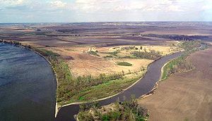
Nishnabotna River
Encyclopedia
Tributary
A tributary or affluent is a stream or river that flows into a main stem river or a lake. A tributary does not flow directly into a sea or ocean...
of the Missouri River
Missouri River
The Missouri River flows through the central United States, and is a tributary of the Mississippi River. It is the longest river in North America and drains the third largest area, though only the thirteenth largest by discharge. The Missouri's watershed encompasses most of the American Great...
in southwestern Iowa
Iowa
Iowa is a state located in the Midwestern United States, an area often referred to as the "American Heartland". It derives its name from the Ioway people, one of the many American Indian tribes that occupied the state at the time of European exploration. Iowa was a part of the French colony of New...
, northwestern Missouri
Missouri
Missouri is a US state located in the Midwestern United States, bordered by Iowa, Illinois, Kentucky, Tennessee, Arkansas, Oklahoma, Kansas and Nebraska. With a 2010 population of 5,988,927, Missouri is the 18th most populous state in the nation and the fifth most populous in the Midwest. It...
and southeastern Nebraska
Nebraska
Nebraska is a state on the Great Plains of the Midwestern United States. The state's capital is Lincoln and its largest city is Omaha, on the Missouri River....
in the United States
United States
The United States of America is a federal constitutional republic comprising fifty states and a federal district...
. It flows for most of its length as two parallel streams in Iowa, the East Nishnabotna River and the West Nishnabotna River. The east and west branches are each about 120 miles (193.1 km) long; from their confluence the Nishnabotna flows approximately another 16 miles (25.7 km).
Several sections of the rivers' courses have been straightened and heavily channelized.
The name "Nishnabotna" comes from a Native American word meaning "canoe-making river."
East Nishnabotna River
Carroll County, Iowa
-2010 census:The 2010 census recorded a population of 20,816 in the county, with a population density of . There were 9,376 housing units, of which 8,683 were occupied.-2000 census:...
and flows generally south-southwestwardly through Audubon
Audubon County, Iowa
-2010 census:The 2010 census recorded a population of 6,119 in the county, with a population density of . There were 2,972 housing units, of which 2,617 were occupied.-2000 census:...
, Cass
Cass County, Iowa
-2010 census:The 2010 census recorded a population of 13,956 in the county, with a population density of . There were 6,591 housing units, of which 5,980 were occupied.-2000 census:...
, Pottawattamie
Pottawattamie County, Iowa
Pottawattamie County is a county located in the U.S. state of Iowa. The population was 93,158 in the 2010 census, an increase from 87,704 in the 2000 census and is the second largest county by area in Iowa. The Pottawattamie county seat is located at Council Bluffs. It is one of three Iowa...
, Montgomery
Montgomery County, Iowa
-2010 census:The 2010 census recorded a population of 10,740 in the county, with a population density of . There were 5,239 housing units, of which 4,558 were occupied.-2000 census:...
, Page
Page County, Iowa
-2010 census:The 2010 census recorded a population of 15,932 in the county, with a population density of . There were 7,181 housing units, of which 6,393 were occupied.-2000 census:...
and Fremont
Fremont County, Iowa
-2010 census:The 2010 census recorded a population of 7,441 in the county, with a population density of . There were 3,431 housing units, of which 3,064 were occupied.-2000 census:...
Counties, past the towns of Exira
Exira, Iowa
Exira is a city in Audubon County, Iowa, United States, along the East Nishnabotna River and U.S. Route 71. The population was 810 at the 2000 census.-History:The oldest town in Audubon County, Exira was founded in 1857...
, Brayton
Brayton, Iowa
Brayton is a city in Audubon County, Iowa, United States, along the East Nishnabotna River. The population was 145 at the 2000 census.-History:In recent decades, Brayton's population has fallen; its 1950 population was 239.-Geography:...
, Atlantic
Atlantic, Iowa
Atlantic is a city in and the county seat of Cass County, Iowa, United States, located along the East Nishnabotna River. The population was 7,112 in the 2010 census, a decline from the 7,257 population in the 2000 census. -History:...
, Lewis
Lewis, Iowa
Lewis is a city in Cass County, Iowa, United States, along the East Nishnabotna River. The population was 438 at the 2000 census.-Geography:Lewis is located at ....
, Elliott
Elliott, Iowa
Elliott is a city in Montgomery County, Iowa, United States, along the East Nishnabotna River. The population was 402 at the 2000 census.-Geography:Elliott is located at ....
, Red Oak
Red Oak, Iowa
-2010 census:The 2010 census recorded a population of 5,742 in the city, with a population density of . There were 2,887 housing units, of which 2,406 were occupied....
and Riverton
Riverton, Iowa
Riverton is a city in Fremont County, Iowa, United States, along the East Nishnabotna River. The population was 304 at the 2000 census. The 1881 robbery of the Sexton Bank at Riverton was suspected to be the work of Jesse James, but it was soon determined to be the work of the outlaw Poke...
.
West Nishnabotna River
The West Nishnabotna River rises in southwestern Carroll County and also flows generally south-southwestwardly through CrawfordCrawford County, Iowa
-2010 census:The 2010 census recorded a population of 17,096 in the county, with a population density of . There were 6,943 housing units, of which 6,413 were occupied.-2000 census:...
, Shelby
Shelby County, Iowa
-2010 census:The 2010 census recorded a population of 12,167 in the county, with a population density of . There were 5,542 housing units, of which 5,085 were occupied.-2000 census:...
, Pottawattamie
Pottawattamie County, Iowa
Pottawattamie County is a county located in the U.S. state of Iowa. The population was 93,158 in the 2010 census, an increase from 87,704 in the 2000 census and is the second largest county by area in Iowa. The Pottawattamie county seat is located at Council Bluffs. It is one of three Iowa...
, Mills
Mills County, Iowa
-2010 census:The 2010 census recorded a population of 15,059 in the county, with a population density of . There were 6,109 housing units, of which 5,605 were occupied.-2000 census:...
and Fremont
Fremont County, Iowa
-2010 census:The 2010 census recorded a population of 7,441 in the county, with a population density of . There were 3,431 housing units, of which 3,064 were occupied.-2000 census:...
Counties, past the towns of Manning
Manning, Iowa
Manning is a city in Carroll County, Iowa, United States, along Iowa Highway 141. The population was 1,490 at the 2000 census. It is named for Orlando Harrison Manning, a Lieutenant Governor of Iowa.-History:...
, Irwin
Irwin, Iowa
Irwin is a city in Shelby County, Iowa, United States, along the West Nishnabotna River. The population was 372 at the 2000 census.-Geography:Irwin is located at ....
, Kirkman
Kirkman, Iowa
Kirkman is a city in Shelby County, Iowa, United States, along the West Nishnabotna River. The population was 76 at the 2000 census.-Geography:Kirkman is located at ....
, Harlan
Harlan, Iowa
Harlan is a city in Shelby County, Iowa, United States, along the West Nishnabotna River. The population was 5,282 at the 2000 census. It is the county seat of Shelby County.-History:...
, Avoca
Avoca, Iowa
Avoca is a city in Pottawattamie County, Iowa, United States. The population was 1,610 at the 2000 census.-History:Avoca was founded in 1869 in connection with the construction of the Chicago, Rock Island and Pacific Railroad through the area. It quickly developed as a regional service center for...
, Hancock
Hancock, Iowa
Hancock is a city in Pottawattamie County, Iowa, United States, along the West Nishnabotna River. The population was 207 at the 2000 census.-Geography:Hancock is located at ....
, Oakland
Oakland, Iowa
Oakland is a city located along the West Nishnabotna River in Pottawattamie County, Iowa, United States. As of the 2000 census, the city had a total population of 1,487. Formerly named Big Grove, Oakland is home to Nishna Heritage Museum...
and Carson
Carson, Iowa
Carson is a city in Pottawattamie County, Iowa, United States. The population was 668 at the 2000 census.-History:Carson was formed in 1881 as a result of the establishment of a depot on the Burlington and Rock Island Railroad at this location during the previous year.-Geography:Carson's longitude...
. At Harlan it collects the West Fork West Nishnabotna River, which rises in southwestern Carroll County and flows southwestwardly through Crawford and Shelby Counties, past Manilla
Manilla, Iowa
Manilla is a city in Crawford County, Iowa, United States, along the West Branch of the West Nishnabotna River. The population was 839 at the 2000 census...
and Defiance
Defiance, Iowa
Defiance is a city in Shelby County, Iowa, United States, along the West Branch of the West Nishnabotna River. The population was 346 at the 2000 census.-Geography:Defiance is located at ....
. Near Avoca it collects the East Branch West Nishnabotna River, which rises in southwestern Carroll County and flows southwestwardly through Audubon, Shelby and Pottawattamie Counties, past Gray
Gray, Iowa
Gray is a city in Audubon County, Iowa, United States, along the East Branch of the West Nishnabotna River. The population was 82 at the 2000 census.-Geography:Gray is located at ....
. The West Nishnabotna was the topic of a humorous song on the 1974 C.W. McCall albums Wolf Creek Pass
Wolf Creek Pass
Wolf Creek Pass is a high mountain pass on the Continental Divide, in the San Juan Mountains of Colorado. It is the route through which U.S. Highway 160 passes from the San Luis Valley into southwest Colorado on its way to New Mexico and Arizona. The pass is notable as inspiration of a C. W....
and Rubber Duck.
Lower river
The East and West rivers merge in southwestern Fremont County and continue as the Nishnabotna River for its short course past HamburgHamburg, Iowa
Hamburg is a city in Fremont County, Iowa, United States, along the Nishnabotna River. The population was 1,240 at the 2000 census.-Geography:According to the United States Census Bureau, the city has a total area of , all of it land.-Demographics:...
and into northwestern Atchison County, Missouri
Atchison County, Missouri
Atchison County is a county located in the U.S. state of Missouri. As of 2010, the population was 5,685. Its county seat is Rock Port. The county was organized in 1845 and named for David Rice Atchison, U.S...
, where it flows into the Missouri River 2 mi (3 km) west of Watson
Watson, Missouri
Watson is a village in Nishnabotna Township, Atchison County, Missouri, United States. The population was 100 at the 2010 census. It is the westernmost settlement in the state of Missouri.-Geography:Watson is located at ....
.
The Nishnabotna River enters Nemaha County, Nebraska
Nemaha County, Nebraska
-Demographics:As of the census of 2000, there were 7,576 people, 3,047 households, and 1,980 families residing in the county. The population density was 18 people per square mile . There were 3,439 housing units at an average density of 8 per square mile...
for about 0.5 mi (0.8 km) just above the confluence with the Missouri River; the Nebraska-Missouri state line runs to the east of the Missouri River in this area. http://www.nebraskatransportation.org/maps/docs/county%20maps/pdfs/cntynema.pdf, http://maps.google.com/maps?ll=40.514517,-95.677271&spn=0.049468,0.070858&t=h&hl=en
Recreation
Parks along the river include Botna Bend in Hancock, Willow Slough Wildlife Management Area 3 miles southwest of Henderson, and Riverton Wildlife Management Area, just north of Riverton. Canoe rentals are available at Botna Bend. The best paddling is between Hancock and Carson on the west fork and between Lewis and Griswold on the east fork (see "Paddling Iowa" by Nate Hoogeveen). The Wabash TraceWabash Trace
The Wabash Trace is a rail trail in Iowa running from the city of Council Bluffs southeast to Blanchard.It was part of the Wabash Railroad's Omaha to St. Louis route. It passes through the towns of Mineola, Silver City, Malvern, Imogene, Shenandoah, Coin and Blanchard. For most of its course,...
hiking trail crosses both forks. At its crossing of the west fork one can see the wreckage of a freight train that derailed and went into the drink in the 1960s.
Variant names
According to the Geographic Names Information SystemGeographic Names Information System
The Geographic Names Information System is a database that contains name and locative information about more than two million physical and cultural features located throughout the United States of America and its territories. It is a type of gazetteer...
, the river has also been known as:
|
|
Trivia
- The Nishnabotna is mentioned in C.W. McCall's Four Wheel Drive, where it is sarcastically referred to as being "a yard wide and a foot deep."
- The West Nishnabotna is mentioned in the 2008 Marilynne Robinson novel Home: A hundred yards ahead of them was the bridge across the West Nishnabotna (page 163)
See also
- List of Iowa rivers
- List of Missouri rivers
- List of Nebraska rivers
- Mormon TrailMormon TrailThe Mormon Trail or Mormon Pioneer Trail is the 1,300 mile route that members of The Church of Jesus Christ of Latter-day Saints traveled from 1846 to 1868...
Sources
- Columbia Gazetteer of North America entry
- DeLormeDeLormeDeLorme is a major vendor of business-to-business and consumer mapping and GPS products and technologies. It is based in Yarmouth, Maine, United States....
(1998). Iowa Atlas & Gazetteer. Yarmouth, Maine: DeLorme. ISBN 0-89933-214-5. - DeLormeDeLormeDeLorme is a major vendor of business-to-business and consumer mapping and GPS products and technologies. It is based in Yarmouth, Maine, United States....
(2002). Missouri Atlas & Gazetteer. Yarmouth, Maine: DeLorme. ISBN 0-89933-353-2. - GNIS entries for , , , ,