
Nikanassin Formation
Encyclopedia
The Nikanassin Formation is a stratigraphical
unit of late Jurassic
age. It is part of the Western Canadian Sedimentary Basin
and is found in western Alberta
, Canada
.
It was named by B.R. MacKay in 1929 for the Nikanassin Range
of the front-central ranges of the Canadian Rockies
. Nikanassin menas "first range" in Cree
. The type locallity is located in Brule
, north of the Yellowhead Highway
.
of the formation is late Jurrasic to early Cretaceous
, specifically Portlandian to Barremian
.
The Nikanassin Formation is overlain by the Cadomin Formation
, and the contact is erosional
, forming a regional angular un-conformity. It is underlain by the Fernie
shales.
, grey shale
, with carbonaceous shales and small carbonaceous streaks. No economic coal
beds are found in the Nikanassin Formation. The stratigraphical beds were deposited in both continental and marine environments.
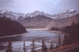
The type locality is found near Brule
, where the formation reaches a thickness of 400 metres (1,312.3 ft). From there it thins out toward east and north.
Stratigraphy
Stratigraphy, a branch of geology, studies rock layers and layering . It is primarily used in the study of sedimentary and layered volcanic rocks....
unit of late Jurassic
Jurassic
The Jurassic is a geologic period and system that extends from about Mya to Mya, that is, from the end of the Triassic to the beginning of the Cretaceous. The Jurassic constitutes the middle period of the Mesozoic era, also known as the age of reptiles. The start of the period is marked by...
age. It is part of the Western Canadian Sedimentary Basin
Western Canadian Sedimentary Basin
The Western Canadian Sedimentary Basin is a vast sedimentary basin underlying of Western Canada including southwestern Manitoba, southern Saskatchewan, Alberta, northeastern British Columbia and the southwest corner of the Northwest Territories. It consists of a massive wedge of sedimentary rock...
and is found in western Alberta
Alberta
Alberta is a province of Canada. It had an estimated population of 3.7 million in 2010 making it the most populous of Canada's three prairie provinces...
, Canada
Canada
Canada is a North American country consisting of ten provinces and three territories. Located in the northern part of the continent, it extends from the Atlantic Ocean in the east to the Pacific Ocean in the west, and northward into the Arctic Ocean...
.
It was named by B.R. MacKay in 1929 for the Nikanassin Range
Nikanassin Range
The Nikanassin Range s a group of mountain ranges in the Canadian Rockies on the eastern edge of Jasper National Park in Alberta, Canada. It is developed south-east of the Fiddle Range, and one of the front ranges. Nikanassin means "first range" in Cree....
of the front-central ranges of the Canadian Rockies
Canadian Rockies
The Canadian Rockies comprise the Canadian segment of the North American Rocky Mountains range. They are the eastern part of the Canadian Cordillera, extending from the Interior Plains of Alberta to the Rocky Mountain Trench of British Columbia. The southern end borders Idaho and Montana of the USA...
. Nikanassin menas "first range" in Cree
Cree language
Cree is an Algonquian language spoken by approximately 117,000 people across Canada, from the Northwest Territories and Alberta to Labrador, making it the aboriginal language with the highest number of speakers in Canada. It is also spoken in the U.S. state of Montana...
. The type locallity is located in Brule
Brûlé, Alberta
Brûlé is a hamlet in west-central Alberta, Canada within Yellowhead County. It is located on the northwest shore of Brûlé Lake, approximately west of Hinton. It has an elevation of .Statistics Canada recognizes Brûlé as a designated place....
, north of the Yellowhead Highway
Yellowhead Highway
The Yellowhead Highway is a major east-west highway connecting the four western Canadian provinces of British Columbia, Alberta, Saskatchewan, and Manitoba. Although part of the Trans-Canada Highway system, the highway should not be confused with the more southerly, originally-designated...
.
Stratigraphy
The ageGeochronology
Geochronology is the science of determining the age of rocks, fossils, and sediments, within a certain degree of uncertainty inherent to the method used. A variety of dating methods are used by geologists to achieve this, and schemes of classification and terminology have been proposed...
of the formation is late Jurrasic to early Cretaceous
Cretaceous
The Cretaceous , derived from the Latin "creta" , usually abbreviated K for its German translation Kreide , is a geologic period and system from circa to million years ago. In the geologic timescale, the Cretaceous follows the Jurassic period and is followed by the Paleogene period of the...
, specifically Portlandian to Barremian
Barremian
The Barremian is an age in the geologic timescale between 130.0 ± 1.5 Ma and 125.0 ± 1.0 Ma). It is a subdivision of the Early Cretaceous epoch...
.
The Nikanassin Formation is overlain by the Cadomin Formation
Cadomin Formation
The Cadomin Formation is a stratigraphical unit of early Cretaceous age. It is part of the Western Canadian Sedimentary Basin and is found in western Alberta, Canada....
, and the contact is erosional
Erosion
Erosion is when materials are removed from the surface and changed into something else. It only works by hydraulic actions and transport of solids in the natural environment, and leads to the deposition of these materials elsewhere...
, forming a regional angular un-conformity. It is underlain by the Fernie
Fernie Formation
The Fernie Formation is a stratigraphical unit of Jurassic age in the Western Canadian Sedimentary Basin. In some interpretation it has Group status.It takes the name from the town of Fernie, British Columbia, and was first defined by Leach in 1914....
shales.
Lithology
The geological formation is composed of sandstoneSandstone
Sandstone is a sedimentary rock composed mainly of sand-sized minerals or rock grains.Most sandstone is composed of quartz and/or feldspar because these are the most common minerals in the Earth's crust. Like sand, sandstone may be any colour, but the most common colours are tan, brown, yellow,...
, grey shale
Shale
Shale is a fine-grained, clastic sedimentary rock composed of mud that is a mix of flakes of clay minerals and tiny fragments of other minerals, especially quartz and calcite. The ratio of clay to other minerals is variable. Shale is characterized by breaks along thin laminae or parallel layering...
, with carbonaceous shales and small carbonaceous streaks. No economic coal
Coal
Coal is a combustible black or brownish-black sedimentary rock usually occurring in rock strata in layers or veins called coal beds or coal seams. The harder forms, such as anthracite coal, can be regarded as metamorphic rock because of later exposure to elevated temperature and pressure...
beds are found in the Nikanassin Formation. The stratigraphical beds were deposited in both continental and marine environments.
The type locality is found near Brule
Brûlé, Alberta
Brûlé is a hamlet in west-central Alberta, Canada within Yellowhead County. It is located on the northwest shore of Brûlé Lake, approximately west of Hinton. It has an elevation of .Statistics Canada recognizes Brûlé as a designated place....
, where the formation reaches a thickness of 400 metres (1,312.3 ft). From there it thins out toward east and north.