
Newport, New Hampshire
Encyclopedia
Newport is a town
in and the county seat
of Sullivan County
, New Hampshire
, United States
. It is 43 miles (69.2 km) west-northwest of Concord
. The population was 6,507 at the 2010 census. A covered bridge
is in the northwest. The area is noted for maple sugar
and apple
orchard
s.
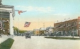
The central settlement in town, where 4,769 people resided at the 2010 census, is defined as the Newport census-designated place
(CDP) and is located next to the Sugar River
at the junction of New Hampshire routes 10
and 11
. The town also includes the villages of Kelleyville and Guild
.
Governor Benning Wentworth
, the town was named Grenville after George Grenville
, Prime Minister of the United Kingdom
and brother-in-law of William Pitt
. But ongoing hostilities during the French and Indian War
, as close as the Fort at Number 4
at Charlestown
, delayed settlement. Nevertheless, in 1761 the town would be incorporated as Newport, for Henry Newport
, a distinguished English
soldier and statesman.
It was first settled in 1763 by pioneers from North Killingworth
, Connecticut
. At that time, the Connecticut River
was the only route for travel, until a road was cut through the wilderness to Charlestown in 1767. The following year, the first gristmill was established. But dissatisfied with treatment by the state government far beyond the mountains, Newport in 1781 joined 33 other towns along the Connecticut River and seceded from New Hampshire
to join Vermont
. George Washington
, however, would dissolve their union with Vermont in 1782, and the towns rejoined New Hampshire.
With excellent soil for farming, and abundant water power from the Sugar River
and its South Branch
to run mills, Newport grew prosperous. The first cotton
mill was established by Colonel James D. Wolcott in 1813. Local cabinet making
flourished, producing much fine furniture. And then in 1817, perhaps inspired by the Erie Canal
, businessmen proposed digging a canal
to connect the Connecticut and Merrimack
rivers—beginning with the Sugar River, and using its source, Lake Sunapee
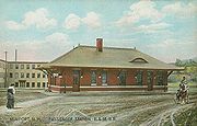
, as a reservoir. The plan was abandoned before it got started. In 1871, the Sugar River Railroad connected to Newport from Bradford
.
But the river was recognized as central to industrial development, and in 1820, mill owners from Claremont
, Sunapee
and Newport united to create the Sunapee Dam Corporation, which built a dam
to regulate the Sugar River's flow, running mill machinery even during drought
. This plan worked, and over 120 water wheels would turn along the stream's course. By 1859, when the population was 2,020, Newport had three woolen
mills and two tanneries
. It also had the Sibley Scythe Company, established in 1842, which manufactured the scythe
s that cleared jungle during construction of the Panama Canal
. It closed in 1929.
The venerable mill town
has significant architectural landmarks, including the 1823 South Congregational Church
designed by Elias Carter, the Newport Opera House
built in 1886, and the Richards Free Library, built as the home of Colonel Seth Mason Richards in 1898.
, the town has a total area of 43.7 square miles (113.2 km²), of which 43.6 sq mi (112.9 km²) is land and 0.1 sq mi (0.258998811 km²) is water, comprising 0.18% of the town.
The central village of Newport, a census-designated place
(CDP), has an area of 10.9 sq mi (28.2 km²), all land.
Newport is drained by the Sugar River
and its South Branch
, with the town center at their confluence. The highest point in town is along its southern border, where an unnamed ridge has an elevation of approximately 1920 feet (585.2 m) above sea level
.
The town is served by state routes 10
, 11
and 103
. Newport is home to Parlin Field Airport
.
of 2000, there were 6,269 people, 2,473 households, and 1,656 families residing in the town. The population density
was 143.9 people per square mile (55.6/km²). There were 2,633 housing units at an average density of 23.3 persons/km² (60.4 persons/sq mi). The racial makeup of the town was 98.01% White, 0.14% African American
, 0.21% Native American, 0.35% Asia
n, 0.00% Pacific Islander, 0.11% from other races, and 1.18% from two or more races. 0.56% of the population were Hispanic
or Latino
of any race.
There were 2,473 households out of which 31.9% had children under the age of 18 living with them, 51.1% were married couples
living together, 10.4% have a woman whose husband does not live with her, and 33.0% were non-families. 25.7% of all households were made up of individuals and 12.2% had someone living alone who was 65 years of age or older. The average household size was 2.49 and the average family size was 2.95.
 In the town the population was spread out with 26.5% under the age of 18, 7.1% from 18 to 24, 29.2% from 25 to 44, 21.8% from 45 to 64, and 15.3% who were 65 years of age or older. The median age was 37 years. For every 100 females there were 97.0 males. For every 100 females age 18 and over, there were 88.3 males.
The median income for a household in the town was $37,442, and the median income for a family was $45,508. Males had a median income of $31,807 versus $22,788 for females. The per capita income
for the town was $16,964. 14.4% of the population and 10.8% of families were below the poverty line. Out of the total people living in poverty, 19.3% are under the age of 18 and 10.0% are 65 or older.
 As of the census
of 2000, there were 4,008 people, 1,581 households, and 1,019 families residing in the central village, a census-designated place
. The population density
was 366.5 people per square mile (141.6/km²). There were 1,676 housing units at an average density of 59.2 persons/km² (153.3 persons/sq mi). The racial makeup of the town was 98.13% White, 0.22% African American, 0.22% Native American, 0.17% Asian, 0.07% from other races, and 1.17% from two or more races. Hispanic or Latino of any race were 0.45% of the population.
There were 1,581 households out of which 31.8% had children under the age of 18 living with them, 48.1% were married couples
living together, 10.8% have a woman whose husband does not live with her, and 35.5% were non-families. 27.8% of all households were made up of individuals and 13.5% had someone living alone who was 65 years of age or older. The average household size was 2.47 and the average family size was 3.00.
In the CDP the population was spread out with 27.0% under the age of 18, 7.7% from 18 to 24, 29.8% from 25 to 44, 20.1% from 45 to 64, and 15.3% who were 65 years of age or older. The median age was 36 years. For every 100 females there were 93.7 males. For every 100 females age 18 and over, there were 84.7 males.
The median income for a household is $35,788, and the median income for a family was $44,453. Males had a median income of $31,676 versus $22,146 for females. The per capita income
for the town was $16,389. About 10.7% of families and 16.1% of the population were below the poverty line, including 20.6% of those under the age of 18 and 12.9% ages 65 or older.
New England town
The New England town is the basic unit of local government in each of the six New England states. Without a direct counterpart in most other U.S. states, New England towns are conceptually similar to civil townships in other states, but are incorporated, possessing powers like cities in other...
in and the county seat
County seat
A county seat is an administrative center, or seat of government, for a county or civil parish. The term is primarily used in the United States....
of Sullivan County
Sullivan County, New Hampshire
-Demographics:As of the census of 2000, there were 40,458 people, 16,530 households, and 11,174 families residing in the county. The population density was 29/; . There were 20,158 housing units at an average density of 38 per square mile...
, New Hampshire
New Hampshire
New Hampshire is a state in the New England region of the northeastern United States of America. The state was named after the southern English county of Hampshire. It is bordered by Massachusetts to the south, Vermont to the west, Maine and the Atlantic Ocean to the east, and the Canadian...
, United States
United States
The United States of America is a federal constitutional republic comprising fifty states and a federal district...
. It is 43 miles (69.2 km) west-northwest of Concord
Concord, New Hampshire
The city of Concord is the capital of the state of New Hampshire in the United States. It is also the county seat of Merrimack County. As of the 2010 census, its population was 42,695....
. The population was 6,507 at the 2010 census. A covered bridge
Covered bridge
A covered bridge is a bridge with enclosed sides and a roof, often accommodating only a single lane of traffic. Most covered bridges are wooden; some newer ones are concrete or metal with glass sides...
is in the northwest. The area is noted for maple sugar
Maple sugar
Maple sugar is a traditional sweetener in the northeastern United States and Canada, prepared from the sap of the sugar maple tree.-Preparation:...
and apple
Apple
The apple is the pomaceous fruit of the apple tree, species Malus domestica in the rose family . It is one of the most widely cultivated tree fruits, and the most widely known of the many members of genus Malus that are used by humans. Apple grow on small, deciduous trees that blossom in the spring...
orchard
Orchard
An orchard is an intentional planting of trees or shrubs that is maintained for food production. Orchards comprise fruit or nut-producing trees which are grown for commercial production. Orchards are also sometimes a feature of large gardens, where they serve an aesthetic as well as a productive...
s.
The central settlement in town, where 4,769 people resided at the 2010 census, is defined as the Newport census-designated place
Census-designated place
A census-designated place is a concentration of population identified by the United States Census Bureau for statistical purposes. CDPs are delineated for each decennial census as the statistical counterparts of incorporated places such as cities, towns and villages...
(CDP) and is located next to the Sugar River
Sugar River (New Hampshire)
The Sugar River is a 27.0 mile long river located in western New Hampshire in the United States. It is a tributary of the Connecticut River, which flows to Long Island Sound....
at the junction of New Hampshire routes 10
New Hampshire Route 10
New Hampshire Route 10 is a north–south state highway in the U.S. state of New Hampshire. Its southern terminus is at the Massachusetts state line in the town of Winchester. In Massachusetts the highway becomes Massachusetts Route 10. Total length of the highway is .-Route description:NH 10...
and 11
New Hampshire Route 11
New Hampshire Route 11 is a long east–west state highway in New Hampshire, running westward along the southern shore of Lake Winnipesaukee. Its eastern terminus is at the Maine state line in the city of Rochester, where it continues north as Maine State Route 11. U.S. Route 202, which runs...
. The town also includes the villages of Kelleyville and Guild
Guild, New Hampshire
Guild is an unincorporated village in the town of Newport in Sullivan County, New Hampshire, in the United States. It is located near the eastern boundary of Newport, along New Hampshire Routes 11 and 103. Route 11 proceeds east to Sunapee and New London, while Route 103 travels southeast to...
.
History
Granted in 1753 by ColonialColony
In politics and history, a colony is a territory under the immediate political control of a state. For colonies in antiquity, city-states would often found their own colonies. Some colonies were historically countries, while others were territories without definite statehood from their inception....
Governor Benning Wentworth
Benning Wentworth
Benning Wentworth was the colonial governor of New Hampshire from 1741 to 1766.-Biography:The eldest child of the John Wentworth who had been Lieutenant Governor, he was born and died in Portsmouth, New Hampshire. Wentworth graduated from Harvard College in 1715...
, the town was named Grenville after George Grenville
George Grenville
George Grenville was a British Whig statesman who rose to the position of Prime Minister of Great Britain. Grenville was born into an influential political family and first entered Parliament in 1741 as an MP for Buckingham...
, Prime Minister of the United Kingdom
Prime Minister of the United Kingdom
The Prime Minister of the United Kingdom of Great Britain and Northern Ireland is the Head of Her Majesty's Government in the United Kingdom. The Prime Minister and Cabinet are collectively accountable for their policies and actions to the Sovereign, to Parliament, to their political party and...
and brother-in-law of William Pitt
William Pitt, 1st Earl of Chatham
William Pitt, 1st Earl of Chatham PC was a British Whig statesman who led Britain during the Seven Years' War...
. But ongoing hostilities during the French and Indian War
French and Indian War
The French and Indian War is the common American name for the war between Great Britain and France in North America from 1754 to 1763. In 1756, the war erupted into the world-wide conflict known as the Seven Years' War and thus came to be regarded as the North American theater of that war...
, as close as the Fort at Number 4
Fort at Number 4
The Fort at Number 4 was the northernmost British settlement along the Connecticut River in New Hampshire until after the French and Indian War. Now known as Charlestown, it was more than from the nearest other British settlement at Fort Dummer. Construction began in 1740 by brothers Stephen,...
at Charlestown
Charlestown, New Hampshire
Charlestown is a town in Sullivan County, New Hampshire, United States. The population was 5,114 at the 2010 census. The town is home to Hubbard State Forest and the headquarters of the Student Conservation Association....
, delayed settlement. Nevertheless, in 1761 the town would be incorporated as Newport, for Henry Newport
Henry Newport, 3rd Earl of Bradford
Henry Newport, 3rd Earl of Bradford was an English peer and Whig politician.The oldest son of the 2nd Earl of Bradford and Mary Wilbraham was educated at Christ Church, Oxford...
, a distinguished English
England
England is a country that is part of the United Kingdom. It shares land borders with Scotland to the north and Wales to the west; the Irish Sea is to the north west, the Celtic Sea to the south west, with the North Sea to the east and the English Channel to the south separating it from continental...
soldier and statesman.
It was first settled in 1763 by pioneers from North Killingworth
Killingworth, Connecticut
Killingworth is a town in Middlesex County, Connecticut, United States. The town's name can easily be confused with another Connecticut town, Killingly; or a Vermont ski area, Killington. The population was 6,018 at the 2000 census.-History:...
, Connecticut
Connecticut
Connecticut is a state in the New England region of the northeastern United States. It is bordered by Rhode Island to the east, Massachusetts to the north, and the state of New York to the west and the south .Connecticut is named for the Connecticut River, the major U.S. river that approximately...
. At that time, the Connecticut River
Connecticut River
The Connecticut River is the largest and longest river in New England, and also an American Heritage River. It flows roughly south, starting from the Fourth Connecticut Lake in New Hampshire. After flowing through the remaining Connecticut Lakes and Lake Francis, it defines the border between the...
was the only route for travel, until a road was cut through the wilderness to Charlestown in 1767. The following year, the first gristmill was established. But dissatisfied with treatment by the state government far beyond the mountains, Newport in 1781 joined 33 other towns along the Connecticut River and seceded from New Hampshire
New Hampshire
New Hampshire is a state in the New England region of the northeastern United States of America. The state was named after the southern English county of Hampshire. It is bordered by Massachusetts to the south, Vermont to the west, Maine and the Atlantic Ocean to the east, and the Canadian...
to join Vermont
Vermont
Vermont is a state in the New England region of the northeastern United States of America. The state ranks 43rd in land area, , and 45th in total area. Its population according to the 2010 census, 630,337, is the second smallest in the country, larger only than Wyoming. It is the only New England...
. George Washington
George Washington
George Washington was the dominant military and political leader of the new United States of America from 1775 to 1799. He led the American victory over Great Britain in the American Revolutionary War as commander-in-chief of the Continental Army from 1775 to 1783, and presided over the writing of...
, however, would dissolve their union with Vermont in 1782, and the towns rejoined New Hampshire.
With excellent soil for farming, and abundant water power from the Sugar River
Sugar River (New Hampshire)
The Sugar River is a 27.0 mile long river located in western New Hampshire in the United States. It is a tributary of the Connecticut River, which flows to Long Island Sound....
and its South Branch
South Branch Sugar River
The South Branch of the Sugar River is a 6.6 mile long river located in western New Hampshire in the United States. It is a tributary of the Sugar River, which flows to the Connecticut River, which flows to Long Island Sound....
to run mills, Newport grew prosperous. The first cotton
Cotton
Cotton is a soft, fluffy staple fiber that grows in a boll, or protective capsule, around the seeds of cotton plants of the genus Gossypium. The fiber is almost pure cellulose. The botanical purpose of cotton fiber is to aid in seed dispersal....
mill was established by Colonel James D. Wolcott in 1813. Local cabinet making
Cabinet making
Cabinet making is the practice of using various woodworking skills to create cabinets, shelving and furniture.Cabinet making involves techniques such as creating appropriate joints, dados, bevels, chamfers and shelving systems, the use of finishing tools such as routers to create decorative...
flourished, producing much fine furniture. And then in 1817, perhaps inspired by the Erie Canal
Erie Canal
The Erie Canal is a waterway in New York that runs about from Albany, New York, on the Hudson River to Buffalo, New York, at Lake Erie, completing a navigable water route from the Atlantic Ocean to the Great Lakes. The canal contains 36 locks and encompasses a total elevation differential of...
, businessmen proposed digging a canal
Canal
Canals are man-made channels for water. There are two types of canal:#Waterways: navigable transportation canals used for carrying ships and boats shipping goods and conveying people, further subdivided into two kinds:...
to connect the Connecticut and Merrimack
Merrimack River
The Merrimack River is a river in the northeastern United States. It rises at the confluence of the Pemigewasset and Winnipesaukee rivers in Franklin, New Hampshire, flows southward into Massachusetts, and then flows northeast until it empties into the Atlantic Ocean at Newburyport...
rivers—beginning with the Sugar River, and using its source, Lake Sunapee
Lake Sunapee
Lake Sunapee is located within Sullivan County and Merrimack County in western New Hampshire, the United States. It is the fifth-largest lake located entirely in New Hampshire....
, as a reservoir. The plan was abandoned before it got started. In 1871, the Sugar River Railroad connected to Newport from Bradford
Bradford, New Hampshire
Bradford is a town in Merrimack County, New Hampshire, United States. The population was 1,650 at the 2010 census. The main village of the town, where 356 people resided at the 2010 census, is defined as the Bradford census-designated place , and is located west of the junction of New Hampshire...
.
But the river was recognized as central to industrial development, and in 1820, mill owners from Claremont
Claremont, New Hampshire
There were 5,685 households out of which 27.4% had children under the age of 18 living with them, 45.5% were married couples living together, 10.3% had a female householder with no husband present, and 39.7% were non-families. 32.2% of all households were made up of individuals and 14.7% had...
, Sunapee
Sunapee, New Hampshire
Sunapee is a town in Sullivan County, New Hampshire, United States. The population was 3,365 at the 2010 census. Sunapee is home to part of Lake Sunapee...
and Newport united to create the Sunapee Dam Corporation, which built a dam
Dam
A dam is a barrier that impounds water or underground streams. Dams generally serve the primary purpose of retaining water, while other structures such as floodgates or levees are used to manage or prevent water flow into specific land regions. Hydropower and pumped-storage hydroelectricity are...
to regulate the Sugar River's flow, running mill machinery even during drought
Drought
A drought is an extended period of months or years when a region notes a deficiency in its water supply. Generally, this occurs when a region receives consistently below average precipitation. It can have a substantial impact on the ecosystem and agriculture of the affected region...
. This plan worked, and over 120 water wheels would turn along the stream's course. By 1859, when the population was 2,020, Newport had three woolen
Woolen
Woolen or woollen is a type of yarn made from carded wool. Woolen yarn is soft, light, stretchy, and full of air. It is thus a good insulator, and makes a good knitting yarn...
mills and two tanneries
Tanning
Tanning is the making of leather from the skins of animals which does not easily decompose. Traditionally, tanning used tannin, an acidic chemical compound from which the tanning process draws its name . Coloring may occur during tanning...
. It also had the Sibley Scythe Company, established in 1842, which manufactured the scythe
Scythe
A scythe is an agricultural hand tool for mowing grass, or reaping crops. It was largely replaced by horse-drawn and then tractor machinery, but is still used in some areas of Europe and Asia. The Grim Reaper is often depicted carrying or wielding a scythe...
s that cleared jungle during construction of the Panama Canal
Panama Canal
The Panama Canal is a ship canal in Panama that joins the Atlantic Ocean and the Pacific Ocean and is a key conduit for international maritime trade. Built from 1904 to 1914, the canal has seen annual traffic rise from about 1,000 ships early on to 14,702 vessels measuring a total of 309.6...
. It closed in 1929.
The venerable mill town
Mill town
A mill town, also known as factory town or mill village, is typically a settlement that developed around one or more mills or factories .- United Kingdom:...
has significant architectural landmarks, including the 1823 South Congregational Church
South Congregational Church (Newport, New Hampshire)
South Congregational Church is a historic church building at 58 S. Main Street in Newport, New Hampshire....
designed by Elias Carter, the Newport Opera House
Newport Opera House
The Newport Opera House is a historic landmark and a fully functioning theatre in the center of Newport in Sullivan County, New Hampshire. It was built in 1886 after the previous town hall and courthouse burned down in 1885. The rebuilt Opera House was noted to have the largest stage north of Boston...
built in 1886, and the Richards Free Library, built as the home of Colonel Seth Mason Richards in 1898.
Geography
According to the United States Census BureauUnited States Census Bureau
The United States Census Bureau is the government agency that is responsible for the United States Census. It also gathers other national demographic and economic data...
, the town has a total area of 43.7 square miles (113.2 km²), of which 43.6 sq mi (112.9 km²) is land and 0.1 sq mi (0.258998811 km²) is water, comprising 0.18% of the town.
The central village of Newport, a census-designated place
Census-designated place
A census-designated place is a concentration of population identified by the United States Census Bureau for statistical purposes. CDPs are delineated for each decennial census as the statistical counterparts of incorporated places such as cities, towns and villages...
(CDP), has an area of 10.9 sq mi (28.2 km²), all land.
Newport is drained by the Sugar River
Sugar River (New Hampshire)
The Sugar River is a 27.0 mile long river located in western New Hampshire in the United States. It is a tributary of the Connecticut River, which flows to Long Island Sound....
and its South Branch
South Branch Sugar River
The South Branch of the Sugar River is a 6.6 mile long river located in western New Hampshire in the United States. It is a tributary of the Sugar River, which flows to the Connecticut River, which flows to Long Island Sound....
, with the town center at their confluence. The highest point in town is along its southern border, where an unnamed ridge has an elevation of approximately 1920 feet (585.2 m) above sea level
Sea level
Mean sea level is a measure of the average height of the ocean's surface ; used as a standard in reckoning land elevation...
.
The town is served by state routes 10
New Hampshire Route 10
New Hampshire Route 10 is a north–south state highway in the U.S. state of New Hampshire. Its southern terminus is at the Massachusetts state line in the town of Winchester. In Massachusetts the highway becomes Massachusetts Route 10. Total length of the highway is .-Route description:NH 10...
, 11
New Hampshire Route 11
New Hampshire Route 11 is a long east–west state highway in New Hampshire, running westward along the southern shore of Lake Winnipesaukee. Its eastern terminus is at the Maine state line in the city of Rochester, where it continues north as Maine State Route 11. U.S. Route 202, which runs...
and 103
New Hampshire Route 103
New Hampshire Route 103 is a long east–west highway in west-central New Hampshire, United States. The highway runs from Claremont, near the Vermont border on the Connecticut River, to Hopkinton, west of Concord....
. Newport is home to Parlin Field Airport
Parlin Field
Parlin Field is a public use airport in Sullivan County, New Hampshire, United States. It is owned by the Town of Newport and is located two nautical miles south of the central business district.Although most U.S...
.
Demographics
In 1900, 3,126 people lived in Newport; in 1910, 3,765; and in 1940, 5,304. As of the censusCensus
A census is the procedure of systematically acquiring and recording information about the members of a given population. It is a regularly occurring and official count of a particular population. The term is used mostly in connection with national population and housing censuses; other common...
of 2000, there were 6,269 people, 2,473 households, and 1,656 families residing in the town. The population density
Population density
Population density is a measurement of population per unit area or unit volume. It is frequently applied to living organisms, and particularly to humans...
was 143.9 people per square mile (55.6/km²). There were 2,633 housing units at an average density of 23.3 persons/km² (60.4 persons/sq mi). The racial makeup of the town was 98.01% White, 0.14% African American
African American
African Americans are citizens or residents of the United States who have at least partial ancestry from any of the native populations of Sub-Saharan Africa and are the direct descendants of enslaved Africans within the boundaries of the present United States...
, 0.21% Native American, 0.35% Asia
Asia
Asia is the world's largest and most populous continent, located primarily in the eastern and northern hemispheres. It covers 8.7% of the Earth's total surface area and with approximately 3.879 billion people, it hosts 60% of the world's current human population...
n, 0.00% Pacific Islander, 0.11% from other races, and 1.18% from two or more races. 0.56% of the population were Hispanic
Hispanic
Hispanic is a term that originally denoted a relationship to Hispania, which is to say the Iberian Peninsula: Andorra, Gibraltar, Portugal and Spain. During the Modern Era, Hispanic sometimes takes on a more limited meaning, particularly in the United States, where the term means a person of ...
or Latino
Latino
The demonyms Latino and Latina , are defined in English language dictionaries as:* "a person of Latin-American descent."* "A Latin American."* "A person of Hispanic, especially Latin-American, descent, often one living in the United States."...
of any race.
There were 2,473 households out of which 31.9% had children under the age of 18 living with them, 51.1% were married couples
Marriage
Marriage is a social union or legal contract between people that creates kinship. It is an institution in which interpersonal relationships, usually intimate and sexual, are acknowledged in a variety of ways, depending on the culture or subculture in which it is found...
living together, 10.4% have a woman whose husband does not live with her, and 33.0% were non-families. 25.7% of all households were made up of individuals and 12.2% had someone living alone who was 65 years of age or older. The average household size was 2.49 and the average family size was 2.95.
The median income for a household in the town was $37,442, and the median income for a family was $45,508. Males had a median income of $31,807 versus $22,788 for females. The per capita income
Per capita income
Per capita income or income per person is a measure of mean income within an economic aggregate, such as a country or city. It is calculated by taking a measure of all sources of income in the aggregate and dividing it by the total population...
for the town was $16,964. 14.4% of the population and 10.8% of families were below the poverty line. Out of the total people living in poverty, 19.3% are under the age of 18 and 10.0% are 65 or older.
Town center
Census
A census is the procedure of systematically acquiring and recording information about the members of a given population. It is a regularly occurring and official count of a particular population. The term is used mostly in connection with national population and housing censuses; other common...
of 2000, there were 4,008 people, 1,581 households, and 1,019 families residing in the central village, a census-designated place
Census-designated place
A census-designated place is a concentration of population identified by the United States Census Bureau for statistical purposes. CDPs are delineated for each decennial census as the statistical counterparts of incorporated places such as cities, towns and villages...
. The population density
Population density
Population density is a measurement of population per unit area or unit volume. It is frequently applied to living organisms, and particularly to humans...
was 366.5 people per square mile (141.6/km²). There were 1,676 housing units at an average density of 59.2 persons/km² (153.3 persons/sq mi). The racial makeup of the town was 98.13% White, 0.22% African American, 0.22% Native American, 0.17% Asian, 0.07% from other races, and 1.17% from two or more races. Hispanic or Latino of any race were 0.45% of the population.
There were 1,581 households out of which 31.8% had children under the age of 18 living with them, 48.1% were married couples
Marriage
Marriage is a social union or legal contract between people that creates kinship. It is an institution in which interpersonal relationships, usually intimate and sexual, are acknowledged in a variety of ways, depending on the culture or subculture in which it is found...
living together, 10.8% have a woman whose husband does not live with her, and 35.5% were non-families. 27.8% of all households were made up of individuals and 13.5% had someone living alone who was 65 years of age or older. The average household size was 2.47 and the average family size was 3.00.
In the CDP the population was spread out with 27.0% under the age of 18, 7.7% from 18 to 24, 29.8% from 25 to 44, 20.1% from 45 to 64, and 15.3% who were 65 years of age or older. The median age was 36 years. For every 100 females there were 93.7 males. For every 100 females age 18 and over, there were 84.7 males.
The median income for a household is $35,788, and the median income for a family was $44,453. Males had a median income of $31,676 versus $22,146 for females. The per capita income
Per capita income
Per capita income or income per person is a measure of mean income within an economic aggregate, such as a country or city. It is calculated by taking a measure of all sources of income in the aggregate and dividing it by the total population...
for the town was $16,389. About 10.7% of families and 16.1% of the population were below the poverty line, including 20.6% of those under the age of 18 and 12.9% ages 65 or older.
Sites of interest
Notable inhabitants
- George BelknapGeorge BelknapRear Admiral George Eugene Belknap was an officer in the United States Navy. USS Belknap was named for him....
, admiral - Edmund BurkeEdmund Burke (congressman)Edmund Burke was a U.S. Representative from New Hampshire.Born in Westminster, Vermont, Burke attended the public schools. He studied law and was admitted to the bar in 1826, commencing practice in Colebrook, New Hampshire. He moved to Claremont, New Hampshire, in 1833 and assumed editorial...
, congressman - Horatio HaleHoratio HaleHoratio Emmons Hale was an American-Canadian ethnologist, philologist and businessman who studied language as a key for classifying ancient peoples and being able to trace their migrations...
, ethnologist - Sarah Josepha HaleSarah Josepha HaleSarah Josepha Buell Hale was an American writer and an influential editor. She is the author of the nursery rhyme "Mary Had a Little Lamb"...
, editor and writer - Edwin Obed StanardEdwin O. StanardEdwin Obed Stanard was a nineteenth century politician, businessman and teacher from Missouri.Born in Newport, New Hampshire, Stanard moved to Iowa Territory with his parents in 1836, completed preparatory studies and moved to St. Louis, Missouri in 1853. He taught school in Illinois in 1854 and...
, congressman - Mason Weare Tappan, congressman and state attorney general
- Billy B. VanBilly B. VanBilly B. Van was a prominent entertainer in the early decades of the 1900s. He was a star, progressively, in minstrel shows, vaudeville, burlesque, the New York stage, and movies. At the same time under another name he was a well known dairy farmer and agriculturist. And, at the same time he was...
, vaudeville star