
New York State Route 343
Encyclopedia
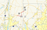
New York State Route 343 (NY 343) is a state highway located entirely within central Dutchess County
, in the Hudson Valley
region of the U.S. state
of New York. It runs east–west from the intersection of NY 82
in the village of Millbrook
to the Connecticut
state line in the town of Amenia
, where it continues eastward briefly as Connecticut Route 343. Along the way, it has a 7.3-mile (11.7 km) concurrency
with NY 22
from vicinity of the hamlet of Dover Plains
to the hamlet of Amenia
.
The entirety of modern Route 343 was originally the Dover branch of the Dutchess Turnpike. The turnpike, which was in operation from the early to the mid-19th century, was a major transportation route at the time, connecting several local communities to Litchfield County, Connecticut
, and the city of Poughkeepsie
. NY 343 was designated in 1930, connecting the hamlet of Amenia to the state line, but was relocated a few years later onto the portion of New York State Route 200 from South Millbrook to the hamlet of Dover Plains. The NY 200 designation was then transferred to NY 343's original alignment. NY 343 absorbed NY 200 in the early 1940s, creating an overlap with NY 22 between Dover Plains and Amenia. The Connecticut portion of the highway was originally designated as part of Route 4; however, it was renumbered to Route 343 in 1932.
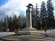
Several landmarks along the way include the Silo Ridge Country Club in the hamlet of Wassaic, Beekman Park
in the hamlet of Amenia, and the Troutbeck Conference Center in the hamlet of Leedsville. When NY 343 crosses the state line, it becomes Connecticut's Route 343 and passes through more rural and residential areas. Route 343 stretches for 1.5 miles (2.41 km) into the town of Sharon, Connecticut
, where it terminates at a junction with Route 4 and Route 41.
(cosigned as U.S. Route 44 or US 44 until 2008) in the hamlet of South Millbrook, located within the village of Millbrook
. The road heads eastward into the town of Washington
, intersecting an old alignment of Route 82 and passing to the south of Millbrook Golf and Tennis Club. Route 343 continues past fields, residential homes, and farms. The highway passes south of the creek, Mill Brook, entering the hamlet of Littlerest, then turns to the southeast at an intersection with County Route 99 (CR 99). At the intersection with CR 23, Route 343 again changes direction, this time to the northeast, and soon crosses Stone Church Brook in the hamlet of Mutton Hollow. Route 343 then changes directions a third time, traveling to the southeast once again towards the hamlet of Dover Plains
.
Northwest of Dover Plains, Route 343 turns to the northeast and passes into the town of Amenia
. Just east of the town line, NY 343 intersects NY 22
. NY 343 turns north onto NY 22, and the joined
routes pass to the west of a series of moderately-sized mountains as they head through regions of rural farms, fields and homes. The roads parallel the Tenmile River and soon intersect with CR 81 (a former routing of NY 22) south of the hamlet of Wassaic
. After passing through Wassaic, the roads cross Wassaic Creek and enter a small valley, soon passing the Wassaic Train Station and continuing northward towards the hamlet of Amenia
.
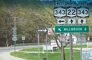
 CR 81 merges with NY 22 and NY 343 as the main roads pass by Beekman Park and Silo Ridge Country Club in the hamlet of Amenia. The roads pass a pond and split at the intersection with US 44. US 44 and NY 22 continue to the north, and NY 343 continues eastward towards the state line. The road passes south of the Amenia Cemetery, changing directions several times. Route 343 then intersects with CR 2 and turns to the northeast, passing over the Webatuck Creek. About 2 miles (3.2 km) later, NY 343 crosses the state line and enters Connecticut.
NY 343 is classified as a rural major collector road
between Millbrook and Dover Plains and carries average annual daily traffic (AADT) of about 3,100 vehicles per day (as of 2006), 5% of which is classified as truck traffic. The portion concurrent with Route 22 is a rural principal arterial road
with average traffic of 5,600 per day (with 7% classified as truck traffic). East of Route 22, Route 343 is a rural minor arterial road carrying about 4,100 vehicles per day (with 6% classified as truck traffic).
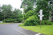 When Route 343 crosses the state line into the town of Sharon
, it enters a moderately rural area where a large factory is located. Route 343, known as Amenia Road, heads northeast towards the town center, passing through patches of forests and intersecting with Sharon Valley Road, a connector to Route 361. After passing north of Sharon Country Club, the highway turns east as it enters the town center, where the surroundings of the highway begin to become populated. Route 343 ends 1.5 miles (2.4 km) from the state line at an intersection with Route 4
and Route 41
south of the town green.
's troops during the American Revolutionary War
and was also the main supply route to the hamlets of Payne's Corners (now Amenia), Washiac (now Wassaic) and Dover Plains. Stone statues that marked the way to different places including New York City
, Fishkill and Boston were put up along the road during the Revolution, helping suppliers of salt
from Boston. This highway grew significantly over the years, with settlements growing along the highway during the early 19th century. There were also a few factories along the route, including a Borden Food Corporation factory that produced condensed milk
in the 1860s.
 Route 343 from the NY 22 / US 44 intersection in Amenia to the Connecticut
state line was part of the main line of the Dutchess Turnpike, which ran from Poughkeepsie
to the state line at Amenia, mostly along modern US 44. Prior to the building of the turnpike, the section of modern Route 343 east of Amenia to the state line was a swamp and did not connect Amenia to the state line. The turnpike corporation was established by law in April 1802 and finished grading the highway in 1805. In May 1803, the continuation of the Dutchess Turnpike into Connecticut, the Goshen and Sharon Turnpike, was also chartered. When the road was completed a few years later, it established a continuous, improved road between Poughkeepsie and Hartford
. In 1806, a branch route, splitting off from the mainline at South Millbrook, was established to connect the hamlet of Dover Plains to Poughkeepsie. The southern branch used modern Route 343 from its western end at US 44 in South Millbrook to NY 22 in Dover Plains. The state took over maintenance of the turnpikes at the beginning of the 20th century.
to the Connecticut state line as the original turnpike did. The road continued into Connecticut as Route 4, a highway that was part of the New England road marking system. In the 1930 state highway renumbering, old NY 21 was broken up into several state routes. The portion between NY 82A west of the hamlet of Amenia
and the Connecticut state line in the town of Sharon
was renumbered as NY 343. In 1932, the continuation of NY 343 in Connecticut was renumbered from Route 4 to Route 343 to match the New York route number.
As part of the 1930 renumbering, the Dover branch of the Dutchess Turnpike between modern NY 82
in the village of Millbrook
and NY 22
north of the hamlet of Dover Plains
was designated as part of NY 200, which began in the city of Poughkeepsie and went via Millbrook to the vicinity of Dover Plains. US 44 was assigned ca. 1935, resulting in the reconfiguration of several state routes in Dutchess County
. Two of the routes affected were NY 200 and NY 343. The alignments of the two routes were swapped, with the former Route 343 between NY 22 in the hamlet of Amenia and the Connecticut state line becoming Route 200 and the portion of former Route 200 between the village of Millbrook and the hamlet of Dover Plains becoming Route 343. The remaining portions of both routes' old routings became part of the new US 44.
The NY 200 designation was removed from the Amenia–Sharon road in the early 1940s and NY 343 was redesignated along that section. The two segments of Route 343 were connected via an overlap with NY 22, which remains to this day.
Dutchess County, New York
Dutchess County is a county located in the U.S. state of New York, in the state's Mid-Hudson Region of the Hudson Valley. The 2010 census lists the population as 297,488...
, in the Hudson Valley
Hudson Valley
The Hudson Valley comprises the valley of the Hudson River and its adjacent communities in New York State, United States, from northern Westchester County northward to the cities of Albany and Troy.-History:...
region of the U.S. state
U.S. state
A U.S. state is any one of the 50 federated states of the United States of America that share sovereignty with the federal government. Because of this shared sovereignty, an American is a citizen both of the federal entity and of his or her state of domicile. Four states use the official title of...
of New York. It runs east–west from the intersection of NY 82
New York State Route 82
New York State Route 82 is a state highway in the eastern Hudson Valley of New York, United States. It begins at an intersection with NY 52 northeast of the village of Fishkill, bends eastward towards Millbrook, and then returns westward to end at a junction with U.S. Route 9,...
in the village of Millbrook
Millbrook, New York
Millbrook is a village in Dutchess County, New York, United States. It is often said to be a "low-key version of the Hamptons" and one of the wealthiest towns in New York State. Millbrook's estimated town population was 1,551 in 2008. Millbrook is located in the Hudson Valley, an hour and thirty...
to the Connecticut
Connecticut
Connecticut is a state in the New England region of the northeastern United States. It is bordered by Rhode Island to the east, Massachusetts to the north, and the state of New York to the west and the south .Connecticut is named for the Connecticut River, the major U.S. river that approximately...
state line in the town of Amenia
Amenia (town), New York
Amenia is a town in Dutchess County, United States. New York, United States. The population was 4,048 at the 2000 census. The name is derived from the Latin word, amoena, which means "pleasant to the eye."...
, where it continues eastward briefly as Connecticut Route 343. Along the way, it has a 7.3-mile (11.7 km) concurrency
Concurrency (road)
A concurrency, overlap, or coincidence in a road network is an instance of one physical road bearing two or more different highway, motorway, or other route numbers...
with NY 22
New York State Route 22
New York State Route 22 is a north–south state highway in eastern New York in the United States. It runs parallel to the state's eastern edge from the outskirts of New York City to a short distance south of the Canadian border. At , it is the state's longest north–south route and...
from vicinity of the hamlet of Dover Plains
Dover Plains, New York
Dover Plains is a hamlet in Dutchess County, New York, United States. The population was 1,996 at the 2000 census...
to the hamlet of Amenia
Amenia (CDP), New York
Amenia is a hamlet in Dutchess County, New York, United States. The population was 1,115 at the 2000 census. It is part of the Poughkeepsie–Newburgh–Middletown, NY Metropolitan Statistical Area as well as the larger New York–Newark–Bridgeport, NY-NJ-CT-PA Combined...
.
The entirety of modern Route 343 was originally the Dover branch of the Dutchess Turnpike. The turnpike, which was in operation from the early to the mid-19th century, was a major transportation route at the time, connecting several local communities to Litchfield County, Connecticut
Litchfield County, Connecticut
Litchfield County is a county located in the northwestern corner of the U.S. state of Connecticut. Litchfield County has the lowest population density of any county in Connecticut but is geographically the state's largest county. As of 2010 the population was 189,927...
, and the city of Poughkeepsie
Poughkeepsie (city), New York
Poughkeepsie is a city in the state of New York, United States, which serves as the county seat of Dutchess County. Poughkeepsie is located in the Hudson River Valley midway between New York City and Albany...
. NY 343 was designated in 1930, connecting the hamlet of Amenia to the state line, but was relocated a few years later onto the portion of New York State Route 200 from South Millbrook to the hamlet of Dover Plains. The NY 200 designation was then transferred to NY 343's original alignment. NY 343 absorbed NY 200 in the early 1940s, creating an overlap with NY 22 between Dover Plains and Amenia. The Connecticut portion of the highway was originally designated as part of Route 4; however, it was renumbered to Route 343 in 1932.
Several landmarks along the way include the Silo Ridge Country Club in the hamlet of Wassaic, Beekman Park
Beekman Park
Beekman Park is a small local park in the census-designated place of Amenia, part of Dutchess County, New York. It is located on U.S. Route 44 and is visible off New York State Route 22 and New York State Route 343 across from a nearby restaurant. In 1974, the land upon which the park is located...
in the hamlet of Amenia, and the Troutbeck Conference Center in the hamlet of Leedsville. When NY 343 crosses the state line, it becomes Connecticut's Route 343 and passes through more rural and residential areas. Route 343 stretches for 1.5 miles (2.41 km) into the town of Sharon, Connecticut
Sharon, Connecticut
Sharon is a town located in Litchfield County, Connecticut, in the northwest corner of the state. It is bounded on the north by Salisbury, on the east by the Housatonic River, on the south by Kent, and on the west by Dutchess County, New York...
, where it terminates at a junction with Route 4 and Route 41.
NY 343
NY 343 begins at an intersection with NY 82New York State Route 82
New York State Route 82 is a state highway in the eastern Hudson Valley of New York, United States. It begins at an intersection with NY 52 northeast of the village of Fishkill, bends eastward towards Millbrook, and then returns westward to end at a junction with U.S. Route 9,...
(cosigned as U.S. Route 44 or US 44 until 2008) in the hamlet of South Millbrook, located within the village of Millbrook
Millbrook, New York
Millbrook is a village in Dutchess County, New York, United States. It is often said to be a "low-key version of the Hamptons" and one of the wealthiest towns in New York State. Millbrook's estimated town population was 1,551 in 2008. Millbrook is located in the Hudson Valley, an hour and thirty...
. The road heads eastward into the town of Washington
Washington, New York
Washington is a town in Dutchess County, New York, United States. The population was 4,742 at the 2000 census. The town is named after George Washington, who passed through the town during the Revolution....
, intersecting an old alignment of Route 82 and passing to the south of Millbrook Golf and Tennis Club. Route 343 continues past fields, residential homes, and farms. The highway passes south of the creek, Mill Brook, entering the hamlet of Littlerest, then turns to the southeast at an intersection with County Route 99 (CR 99). At the intersection with CR 23, Route 343 again changes direction, this time to the northeast, and soon crosses Stone Church Brook in the hamlet of Mutton Hollow. Route 343 then changes directions a third time, traveling to the southeast once again towards the hamlet of Dover Plains
Dover Plains, New York
Dover Plains is a hamlet in Dutchess County, New York, United States. The population was 1,996 at the 2000 census...
.
Northwest of Dover Plains, Route 343 turns to the northeast and passes into the town of Amenia
Amenia (town), New York
Amenia is a town in Dutchess County, United States. New York, United States. The population was 4,048 at the 2000 census. The name is derived from the Latin word, amoena, which means "pleasant to the eye."...
. Just east of the town line, NY 343 intersects NY 22
New York State Route 22
New York State Route 22 is a north–south state highway in eastern New York in the United States. It runs parallel to the state's eastern edge from the outskirts of New York City to a short distance south of the Canadian border. At , it is the state's longest north–south route and...
. NY 343 turns north onto NY 22, and the joined
Concurrency (road)
A concurrency, overlap, or coincidence in a road network is an instance of one physical road bearing two or more different highway, motorway, or other route numbers...
routes pass to the west of a series of moderately-sized mountains as they head through regions of rural farms, fields and homes. The roads parallel the Tenmile River and soon intersect with CR 81 (a former routing of NY 22) south of the hamlet of Wassaic
Wassaic, New York
Wassaic is a hamlet in the Town of Amenia, Dutchess County, New York in the United States.Wassaic is located in southeast New York State and surrounded by the East and West Mountains and along the Tenmile River....
. After passing through Wassaic, the roads cross Wassaic Creek and enter a small valley, soon passing the Wassaic Train Station and continuing northward towards the hamlet of Amenia
Amenia (CDP), New York
Amenia is a hamlet in Dutchess County, New York, United States. The population was 1,115 at the 2000 census. It is part of the Poughkeepsie–Newburgh–Middletown, NY Metropolitan Statistical Area as well as the larger New York–Newark–Bridgeport, NY-NJ-CT-PA Combined...
.
NY 343 is classified as a rural major collector road
Collector road
A collector road or distributor road is a low to moderate-capacity road which serve to move traffic from local streets to arterial roads. Unlike arterials, collectors are also designed to provide access to residential properties...
between Millbrook and Dover Plains and carries average annual daily traffic (AADT) of about 3,100 vehicles per day (as of 2006), 5% of which is classified as truck traffic. The portion concurrent with Route 22 is a rural principal arterial road
Arterial road
An arterial road, or arterial thoroughfare, is a high-capacity urban road. The primary function of an arterial road is to deliver traffic from collector roads to freeways, and between urban centres at the highest level of service possible. As such, many arteries are limited-access roads, or feature...
with average traffic of 5,600 per day (with 7% classified as truck traffic). East of Route 22, Route 343 is a rural minor arterial road carrying about 4,100 vehicles per day (with 6% classified as truck traffic).
CT 343
Sharon, Connecticut
Sharon is a town located in Litchfield County, Connecticut, in the northwest corner of the state. It is bounded on the north by Salisbury, on the east by the Housatonic River, on the south by Kent, and on the west by Dutchess County, New York...
, it enters a moderately rural area where a large factory is located. Route 343, known as Amenia Road, heads northeast towards the town center, passing through patches of forests and intersecting with Sharon Valley Road, a connector to Route 361. After passing north of Sharon Country Club, the highway turns east as it enters the town center, where the surroundings of the highway begin to become populated. Route 343 ends 1.5 miles (2.4 km) from the state line at an intersection with Route 4
Route 4 (Connecticut)
Route 4 is an east–west primary state highway connecting rural Litchfield County to the Greater Hartford area of the U.S. state of Connecticut...
and Route 41
Route 41 (Connecticut)
Route 41 is a scenic state highway in rural Northwestern Connecticut. It extends from the New York state line in Sharon to the Massachusetts state line in Salisbury and is the only state-numbered route in Connecticut that has both its ends at a state border....
south of the town green.
Old roads
The alignment used by modern Route 343 was a major transportation route that passed through the colonial settlements of Wassaic and Amenia. The highway helped General George WashingtonGeorge Washington
George Washington was the dominant military and political leader of the new United States of America from 1775 to 1799. He led the American victory over Great Britain in the American Revolutionary War as commander-in-chief of the Continental Army from 1775 to 1783, and presided over the writing of...
's troops during the American Revolutionary War
American Revolutionary War
The American Revolutionary War , the American War of Independence, or simply the Revolutionary War, began as a war between the Kingdom of Great Britain and thirteen British colonies in North America, and ended in a global war between several European great powers.The war was the result of the...
and was also the main supply route to the hamlets of Payne's Corners (now Amenia), Washiac (now Wassaic) and Dover Plains. Stone statues that marked the way to different places including New York City
New York City
New York is the most populous city in the United States and the center of the New York Metropolitan Area, one of the most populous metropolitan areas in the world. New York exerts a significant impact upon global commerce, finance, media, art, fashion, research, technology, education, and...
, Fishkill and Boston were put up along the road during the Revolution, helping suppliers of salt
Salt
In chemistry, salts are ionic compounds that result from the neutralization reaction of an acid and a base. They are composed of cations and anions so that the product is electrically neutral...
from Boston. This highway grew significantly over the years, with settlements growing along the highway during the early 19th century. There were also a few factories along the route, including a Borden Food Corporation factory that produced condensed milk
Condensed milk
Condensed milk, also known as sweetened condensed milk, is cow's milk from which water has been removed and to which sugar has been added, yielding a very thick, sweet product which when canned can last for years without refrigeration if unopened. The two terms, condensed milk and sweetened...
in the 1860s.
Connecticut
Connecticut is a state in the New England region of the northeastern United States. It is bordered by Rhode Island to the east, Massachusetts to the north, and the state of New York to the west and the south .Connecticut is named for the Connecticut River, the major U.S. river that approximately...
state line was part of the main line of the Dutchess Turnpike, which ran from Poughkeepsie
Poughkeepsie (city), New York
Poughkeepsie is a city in the state of New York, United States, which serves as the county seat of Dutchess County. Poughkeepsie is located in the Hudson River Valley midway between New York City and Albany...
to the state line at Amenia, mostly along modern US 44. Prior to the building of the turnpike, the section of modern Route 343 east of Amenia to the state line was a swamp and did not connect Amenia to the state line. The turnpike corporation was established by law in April 1802 and finished grading the highway in 1805. In May 1803, the continuation of the Dutchess Turnpike into Connecticut, the Goshen and Sharon Turnpike, was also chartered. When the road was completed a few years later, it established a continuous, improved road between Poughkeepsie and Hartford
Hartford, Connecticut
Hartford is the capital of the U.S. state of Connecticut. The seat of Hartford County until Connecticut disbanded county government in 1960, it is the second most populous city on New England's largest river, the Connecticut River. As of the 2010 Census, Hartford's population was 124,775, making...
. In 1806, a branch route, splitting off from the mainline at South Millbrook, was established to connect the hamlet of Dover Plains to Poughkeepsie. The southern branch used modern Route 343 from its western end at US 44 in South Millbrook to NY 22 in Dover Plains. The state took over maintenance of the turnpikes at the beginning of the 20th century.
Designation
In 1924, the main line of the Dutchess Turnpike was designated as NY 21, connecting the city of PoughkeepsiePoughkeepsie (city), New York
Poughkeepsie is a city in the state of New York, United States, which serves as the county seat of Dutchess County. Poughkeepsie is located in the Hudson River Valley midway between New York City and Albany...
to the Connecticut state line as the original turnpike did. The road continued into Connecticut as Route 4, a highway that was part of the New England road marking system. In the 1930 state highway renumbering, old NY 21 was broken up into several state routes. The portion between NY 82A west of the hamlet of Amenia
Amenia (CDP), New York
Amenia is a hamlet in Dutchess County, New York, United States. The population was 1,115 at the 2000 census. It is part of the Poughkeepsie–Newburgh–Middletown, NY Metropolitan Statistical Area as well as the larger New York–Newark–Bridgeport, NY-NJ-CT-PA Combined...
and the Connecticut state line in the town of Sharon
Sharon, Connecticut
Sharon is a town located in Litchfield County, Connecticut, in the northwest corner of the state. It is bounded on the north by Salisbury, on the east by the Housatonic River, on the south by Kent, and on the west by Dutchess County, New York...
was renumbered as NY 343. In 1932, the continuation of NY 343 in Connecticut was renumbered from Route 4 to Route 343 to match the New York route number.
As part of the 1930 renumbering, the Dover branch of the Dutchess Turnpike between modern NY 82
New York State Route 82
New York State Route 82 is a state highway in the eastern Hudson Valley of New York, United States. It begins at an intersection with NY 52 northeast of the village of Fishkill, bends eastward towards Millbrook, and then returns westward to end at a junction with U.S. Route 9,...
in the village of Millbrook
Millbrook, New York
Millbrook is a village in Dutchess County, New York, United States. It is often said to be a "low-key version of the Hamptons" and one of the wealthiest towns in New York State. Millbrook's estimated town population was 1,551 in 2008. Millbrook is located in the Hudson Valley, an hour and thirty...
and NY 22
New York State Route 22
New York State Route 22 is a north–south state highway in eastern New York in the United States. It runs parallel to the state's eastern edge from the outskirts of New York City to a short distance south of the Canadian border. At , it is the state's longest north–south route and...
north of the hamlet of Dover Plains
Dover Plains, New York
Dover Plains is a hamlet in Dutchess County, New York, United States. The population was 1,996 at the 2000 census...
was designated as part of NY 200, which began in the city of Poughkeepsie and went via Millbrook to the vicinity of Dover Plains. US 44 was assigned ca. 1935, resulting in the reconfiguration of several state routes in Dutchess County
Dutchess County, New York
Dutchess County is a county located in the U.S. state of New York, in the state's Mid-Hudson Region of the Hudson Valley. The 2010 census lists the population as 297,488...
. Two of the routes affected were NY 200 and NY 343. The alignments of the two routes were swapped, with the former Route 343 between NY 22 in the hamlet of Amenia and the Connecticut state line becoming Route 200 and the portion of former Route 200 between the village of Millbrook and the hamlet of Dover Plains becoming Route 343. The remaining portions of both routes' old routings became part of the new US 44.
The NY 200 designation was removed from the Amenia–Sharon road in the early 1940s and NY 343 was redesignated along that section. The two segments of Route 343 were connected via an overlap with NY 22, which remains to this day.