

New York State Route 62A
Encyclopedia
U.S. Route 62 Business (US 62 Business) is a business route
of US 62
located within the city of Niagara Falls, New York
, in the United States. It follows Pine Avenue through downtown Niagara Falls, spanning 2.12 miles (3.41 km) between New York State Route 104 (NY 104) at its western terminus and US 62 at its eastern extent. Although it runs in a mostly east–west direction, it is signed as a north–south route due to US 62 being signed north–south as well within New York.
Pine Avenue was originally designated as part of NY 34 in 1924. It then became part of NY 18
after it replaced NY 34 in 1930. Ca. 1932, US 62 was extended into New York and overlapped NY 18 between Dayton
and Niagara Falls. NY 18 was truncated to Lewiston, a village north of the city, in the early 1960s, making US 62 the sole occupant of Pine Avenue. US 62 was shifted onto its current alignment through the city later in the decade, allowing Pine Avenue to become New York State Route 62A in the early 1970s. NY 62A was redesignated as US 62 Business in 2006.
 US 62 Business begins at the intersection of Main Street (NY 104
) and Pine Avenue in downtown Niagara Falls
. Unlike the two streets—Walnut and Ferry Avenues—that carry US 62 through Niagara Falls to the south, Pine Avenue is a two-way street, the first such east–west street accessible from NY 104 heading north from the Rainbow Bridge
. Heading east from NY 104, US 62 Business passes through a largely commercial neighborhood. At a signalized intersection with 7th Street two blocks from NY 104, the surroundings become residential in nature; however, the area reverts back to strictly commercial structures at 10th Street. Between 10th and Portage Road, a local north–south arterial, US 62 Business passes along the northern edge of the Niagara Falls Memorial Medical Center
.
Past Portage Road, US 62 Business runs past the northern grounds of the Niagara Arts and Cultural Center (the former location of Niagara Falls High School
) as it enters a neighborhood of Niagara Falls known as "Little Italy", as denoted by a large overhead structure that spans the width of Pine Avenue. Although this area is mostly commercial as well, it features decorative elements not found west of Portage Road, such as stylized streetlights alongside the roadway. The district extends for 1.25 miles (2.01 km) eastward to Hyde Park Boulevard (NY 61
), where another overhead sign denotes the eastern edge of Little Italy.
The last segment of US 62 Business differs greatly from the remainder of the route. On its northern edge, US 62 Business is bounded by Hyde Park, a large city park surrounding Gill Creek; to the south is a fully residential neighborhood. It is during this stretch that Pine Street widens from two to four traffic lanes (while Pine is four lanes wide its entire length, from NY 104 to NY 61 the extra lanes are for parking). 0.34 mile (0.5471756 km) east of NY 61, US 62 Business breaks from its strictly east–west routing and curves south to meet US 62
. US 62 Business northbound (west) begins at Walnut Avenue (US 62 north); however, US 62 Business south continues for another 0.25 mile (0.402335 km) to the junction of Packard Road (US 62 south) and Niagara Falls Boulevard (bi-directional US 62). All of US 62 Business is maintained by the city of Niagara Falls.
was originally designated as part of NY 34 when the first set of posted routes in New York were assigned in 1924. In the 1930 renumbering of state highways of New York, NY 34 was replaced by an extended NY 18
. When US 62
was extended into New York
ca. 1932, it overlapped NY 18 from Dayton
to Niagara Falls. US 62 then ended at the junction of Pine Avenue and Main Street while NY 18 continued north on Main Street toward Lewiston. This overlap remained in place until ca. 1962 when NY 18 was truncated to then-US 104 in Lewiston.
US 62 remained routed on Pine Avenue until the mid-1960s when it was shifted south onto Walnut and Ferry Avenues, which had been transformed into a one-way couplet. Its former routing on Pine Avenue was designated as NY 62A in the early 1970s. This designation remained in place until 2006 when NY 62A was redesignated as US 62 Business by the American Association of State Highway and Transportation Officials
at the request of the New York State Department of Transportation
and the city of Niagara Falls.
Business route
A business route in the United States and Canada is a short special route connected to a parent numbered highway at its beginning, then routed through the central business district of a nearby city or town, and finally reconnecting with the same parent numbered highway again at its...
of US 62
U.S. Route 62 in New York
U.S. Route 62 is a part of the U.S. Highway System that runs from the United States – Mexico border at El Paso, Texas, to Niagara Falls, New York. In the U.S. state of New York, US 62 extends from the New York – Pennsylvania border south of Jamestown to an intersection with...
located within the city of Niagara Falls, New York
Niagara Falls, New York
Niagara Falls is a city in Niagara County, New York, United States. As of the 2010 census, the city had a total population of 50,193, down from the 55,593 recorded in the 2000 census. It is across the Niagara River from Niagara Falls, Ontario , both named after the famed Niagara Falls which they...
, in the United States. It follows Pine Avenue through downtown Niagara Falls, spanning 2.12 miles (3.41 km) between New York State Route 104 (NY 104) at its western terminus and US 62 at its eastern extent. Although it runs in a mostly east–west direction, it is signed as a north–south route due to US 62 being signed north–south as well within New York.
Pine Avenue was originally designated as part of NY 34 in 1924. It then became part of NY 18
New York State Route 18
New York State Route 18 is an east–west state highway in western New York in the United States. It runs parallel to the south shore of Lake Ontario for most of its length between Niagara County and Monroe County...
after it replaced NY 34 in 1930. Ca. 1932, US 62 was extended into New York and overlapped NY 18 between Dayton
Dayton, New York
Dayton is a town in Cattaraugus County, New York, United States. The population was 1,945 at the 2000 census.The Town of Dayton is on the western border of Cattaraugus County.- History :...
and Niagara Falls. NY 18 was truncated to Lewiston, a village north of the city, in the early 1960s, making US 62 the sole occupant of Pine Avenue. US 62 was shifted onto its current alignment through the city later in the decade, allowing Pine Avenue to become New York State Route 62A in the early 1970s. NY 62A was redesignated as US 62 Business in 2006.
Route description
New York State Route 104
New York State Route 104 is a long east–west state highway in Upstate New York, United States. It spans six counties and enters the vicinity of four cities—Niagara Falls, Lockport, Rochester, and Oswego—as it follows a routing largely parallel to that of the southern shoreline of Lake...
) and Pine Avenue in downtown Niagara Falls
Niagara Falls, New York
Niagara Falls is a city in Niagara County, New York, United States. As of the 2010 census, the city had a total population of 50,193, down from the 55,593 recorded in the 2000 census. It is across the Niagara River from Niagara Falls, Ontario , both named after the famed Niagara Falls which they...
. Unlike the two streets—Walnut and Ferry Avenues—that carry US 62 through Niagara Falls to the south, Pine Avenue is a two-way street, the first such east–west street accessible from NY 104 heading north from the Rainbow Bridge
Rainbow Bridge (Niagara Falls)
The Rainbow Bridge at Niagara Falls is an international steel arch bridge across the Niagara River gorge, and is a world-famous tourist site. It connects the cities of Niagara Falls, New York, United States , and Niagara Falls, Ontario, Canada .-Construction:The Rainbow Bridge was built near the...
. Heading east from NY 104, US 62 Business passes through a largely commercial neighborhood. At a signalized intersection with 7th Street two blocks from NY 104, the surroundings become residential in nature; however, the area reverts back to strictly commercial structures at 10th Street. Between 10th and Portage Road, a local north–south arterial, US 62 Business passes along the northern edge of the Niagara Falls Memorial Medical Center
Niagara Falls Memorial Medical Center
Niagara Falls Memorial Medical Center is a hospital in downtown Niagara Falls in the U.S. state of New York that has been meeting the health care needs of the Greater Niagara region for 115 years....
.
Past Portage Road, US 62 Business runs past the northern grounds of the Niagara Arts and Cultural Center (the former location of Niagara Falls High School
Niagara Falls High School
Niagara Falls High School is a high school located at 4455 Porter Road in Niagara Falls New York. Niagara Falls High School was established in 2000, with the merging of the "old" Niagara Falls High School and La Salle High School, both located in Niagara Falls...
) as it enters a neighborhood of Niagara Falls known as "Little Italy", as denoted by a large overhead structure that spans the width of Pine Avenue. Although this area is mostly commercial as well, it features decorative elements not found west of Portage Road, such as stylized streetlights alongside the roadway. The district extends for 1.25 miles (2.01 km) eastward to Hyde Park Boulevard (NY 61
New York State Route 61
New York State Route 61 is a state highway located almost entirely in the city of Niagara Falls in Niagara County, New York in the United States. The road runs across the city in a northwest–southeast direction, terminating at NY 384 at its southern extent and NY 104 at its northern...
), where another overhead sign denotes the eastern edge of Little Italy.
The last segment of US 62 Business differs greatly from the remainder of the route. On its northern edge, US 62 Business is bounded by Hyde Park, a large city park surrounding Gill Creek; to the south is a fully residential neighborhood. It is during this stretch that Pine Street widens from two to four traffic lanes (while Pine is four lanes wide its entire length, from NY 104 to NY 61 the extra lanes are for parking). 0.34 mile (0.5471756 km) east of NY 61, US 62 Business breaks from its strictly east–west routing and curves south to meet US 62
U.S. Route 62 in New York
U.S. Route 62 is a part of the U.S. Highway System that runs from the United States – Mexico border at El Paso, Texas, to Niagara Falls, New York. In the U.S. state of New York, US 62 extends from the New York – Pennsylvania border south of Jamestown to an intersection with...
. US 62 Business northbound (west) begins at Walnut Avenue (US 62 north); however, US 62 Business south continues for another 0.25 mile (0.402335 km) to the junction of Packard Road (US 62 south) and Niagara Falls Boulevard (bi-directional US 62). All of US 62 Business is maintained by the city of Niagara Falls.
History
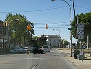
Pine Avenue in Niagara FallsNiagara Falls, New York
Niagara Falls is a city in Niagara County, New York, United States. As of the 2010 census, the city had a total population of 50,193, down from the 55,593 recorded in the 2000 census. It is across the Niagara River from Niagara Falls, Ontario , both named after the famed Niagara Falls which they...
was originally designated as part of NY 34 when the first set of posted routes in New York were assigned in 1924. In the 1930 renumbering of state highways of New York, NY 34 was replaced by an extended NY 18
New York State Route 18
New York State Route 18 is an east–west state highway in western New York in the United States. It runs parallel to the south shore of Lake Ontario for most of its length between Niagara County and Monroe County...
. When US 62
U.S. Route 62 in New York
U.S. Route 62 is a part of the U.S. Highway System that runs from the United States – Mexico border at El Paso, Texas, to Niagara Falls, New York. In the U.S. state of New York, US 62 extends from the New York – Pennsylvania border south of Jamestown to an intersection with...
was extended into New York
New York
New York is a state in the Northeastern region of the United States. It is the nation's third most populous state. New York is bordered by New Jersey and Pennsylvania to the south, and by Connecticut, Massachusetts and Vermont to the east...
ca. 1932, it overlapped NY 18 from Dayton
Dayton, New York
Dayton is a town in Cattaraugus County, New York, United States. The population was 1,945 at the 2000 census.The Town of Dayton is on the western border of Cattaraugus County.- History :...
to Niagara Falls. US 62 then ended at the junction of Pine Avenue and Main Street while NY 18 continued north on Main Street toward Lewiston. This overlap remained in place until ca. 1962 when NY 18 was truncated to then-US 104 in Lewiston.
US 62 remained routed on Pine Avenue until the mid-1960s when it was shifted south onto Walnut and Ferry Avenues, which had been transformed into a one-way couplet. Its former routing on Pine Avenue was designated as NY 62A in the early 1970s. This designation remained in place until 2006 when NY 62A was redesignated as US 62 Business by the American Association of State Highway and Transportation Officials
American Association of State Highway and Transportation Officials
AASHTO, the American Association of State Highway and Transportation Officials, is a standards setting body which publishes specifications, test protocols and guidelines which are used in highway design and construction throughout the United States...
at the request of the New York State Department of Transportation
New York State Department of Transportation
The New York State Department of Transportation is responsible for the development and operation of highways, railroads, mass transit systems, ports, waterways and aviation facilities in the U.S...
and the city of Niagara Falls.