
New York State Route 31F
Encyclopedia
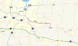
New York State Route 31F (NY 31F) is an east–west state highway
located in the vicinity of Rochester, New York
, in the United States. The western terminus of the route is at an intersection with NY 96
north of the Monroe County
village of Pittsford
. Its eastern terminus is at a junction with NY 31
in the Wayne County
village of Macedon
. Along the way, NY 31F serves the villages of East Rochester
and Fairport
and connects to Interstate 490
(I-490) in the town of Pittsford
. From Fairport eastward, NY 31F roughly parallels the Erie Canal
, which the route crosses over twice: once west of Fairport and again north of Macedon.
The origins of NY 31F date back to 1908 when the modern alignment of the route was designated as part of Route 20 by the New York State Legislature. Route 20, an unsigned legislative route
, was rerouted in 1921 to use NY 31 and NY 250
between Macedon and Fairport instead. Ca. 1931, the section of Route 20's pre-1921 alignment west of modern NY 350
became part of New York State Route 33B, an alternate route of NY 33
(now NY 441
) that extended from Pittsford to Walworth
via Macedon Center. NY 33 was truncated to end in Rochester in the late 1940s, at which time NY 33B was renumbered to NY 31F and rerouted to end in Macedon.
 Upon separating from NY 96 in the town of Pittsford
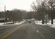
directly in front of St. John Fisher College, NY 31F becomes Fairport Road, the name that the route dons for its first 3.4 miles (5.5 km). The highway, four lanes wide, heads east, skirting the southern edge of the St. John Fisher campus for a half-mile (0.8 km) before connecting to I-490
at exit 25. Past the expressway, NY 31F begins to straddle the boundary line between the village of East Rochester
and the town of Pittsford. After intersecting NY 153
, the primary roadway linking East Rochester and the village of Pittsford
, NY 31F passes to the south of the East Rochester K–12 Campus
prior to leaving the vicinity of the village and entering Perinton
.
Within Perinton, the route initially passes through residential areas similar to those located in East Rochester and Pittsford but soon enters a heavily commercial area centered around the intersection between NY 31F and Jefferson Avenue. During this stretch, the route passes under the CSX Transportation
-owned West Shore Subdivision
railroad line, here situated on a large embankment. At the eastern edge of the commercial strip, NY 31F narrows to two lanes and crosses over the Erie Canal
into Fairport
, where it becomes West Church Street.
NY 31F continues through the residential western portion of the village to an intersection with NY 250
(South Main Street) just south of the village's business district and adjacent to the First Baptist Church of Fairport
. After crossing NY 250, NY 31F becomes East Church Street and begins to parallel the canal as both exit the village. Now solely in Perinton once more, NY 31F cuts to the north along Turk Hill Road, crossing the Erie Canal and the Rochester Subdivision
, CSX's main line
through the Rochester area, on a large overpass. The route resumes its eastward path at an intersection with High Street in the northeast corner of the village, becoming Macedon Center Road in the process.
East of Fairport, the route becomes predominantly rural in nature in a stark departure from its first 6 miles (10 km). NY 31F heads east on a nearly-linear routing through eastern Perinton and the Wayne County
town of Macedon
to the hamlet of Macedon Center, located at the junction of NY 31F and Canandaigua Road. Not long after, NY 31F encounters NY 350
. Here, NY 31F and NY 350 turn south, concurrently
following Ontario Center Road for 1.75 miles (2.82 km) to the village of Macedon
, where both NY 31F and NY 350 terminate at NY 31
. During this final stretch, NY 31F passes under the CSX main line and over the Erie Canal once again.
Maintenance of NY 31F is split between the New York State Department of Transportation
(NYSDOT), the village of Fairport, and Monroe County
. The highway is state-maintained from NY 96 east to the Fairport village line, at which point ownership and maintenance of the road shifts to the village. NY 31F becomes a state highway once again at NY 250 and remains NYSDOT-maintained until it turns north onto the county-owned and maintained Turk Hill Road. While on Turk Hill Road, NY 31F overlaps with County Route 50, the designation assigned to the entire length of Turk Hill Road within Monroe County. The remainder of NY 31F east of Turk Hill Road is state-maintained.
, by the New York State Legislature in 1908. Route 20 entered the village of Macedon
on modern NY 31
and continued westward to Rochester
on current NY 96
. On March 1, 1921, Route 20 was realigned to utilize modern NY 31 and NY 250
between Macedon and Fairport
. Although all of modern NY 31F was part of a legislative route at one time and was state-maintained west of Fairport and from Macedon Center to Macedon by 1926, it was not assigned a posted route number until the 1930s.
Ca. 1931, the portion of current NY 31F west of NY 350
in the town of Macedon
was designated as part of NY 33B, which continued north on modern NY 350 to an intersection with NY 33
(now NY 441
) in Walworth
. NY 350 was assigned by the following year; however, it was initially confined to the segment it now shares with NY 31F between NY 31 in the village of Macedon and then-NY 33B. NY 350 was extended northward to Ontario Center in the early 1940s, overlapping NY 33B from Macedon to Walworth. NY 33 was truncated westward to Rochester in the late 1940s. As a result, NY 33B was renumbered to NY 31F and rerouted east of Macedon Center to travel south along NY 350 to Macedon, where it connected to NY 31.
The first section of the Eastern Expressway (now I-490
) opened in the mid-1950s, extending from NY 31F south to NY 96 in Bushnell's Basin. Initially, NY 96 was realigned to follow the freeway between the two locations and Fairport Road between the north end of the freeway and its original routing on East Avenue. As a result, NY 31F was truncated to begin at the new freeway. The latter change was short-lived, however, as NY 31F was re-extended to its original terminus ca. 1957 after NY 96 was moved onto a northwestern extension of the Eastern Expressway to what is now the Can of Worms in Rochester.
NY 31F originally ran through the center of Fairport, turning north at NY 250 and sharing Main Street with NY 250 on a short concurrency between Church Street and High Street. NY 31F turned east at High Street and followed it to Turk Hill Road, where NY 31F continued east on its current alignment. The route was realigned onto its current alignment through Fairport on April 1, 1984, as a result of a highway maintenance swap between the state of New York
and the village of Fairport. In the swap, ownership and maintenance of High Street was transferred from the state to Fairport in exchange for control over the portion of East Church Street between NY 250 and Turk Hill Road.
State highway
State highway, state road or state route can refer to one of three related concepts, two of them related to a state or provincial government in a country that is divided into states or provinces :#A...
located in the vicinity of Rochester, New York
Rochester, New York
Rochester is a city in Monroe County, New York, south of Lake Ontario in the United States. Known as The World's Image Centre, it was also once known as The Flour City, and more recently as The Flower City...
, in the United States. The western terminus of the route is at an intersection with NY 96
New York State Route 96
New York State Route 96 is a northwest–southeast state highway in the Finger Lakes region of New York in the United States. The southern terminus of the route is at an interchange with NY 17 in the Southern Tier village of Owego, Tioga County. Its northern terminus is at a junction with...
north of the Monroe County
Monroe County, New York
Monroe County is a county located in the U.S. state of New York. As of the 2010 census, the population was 744,344. It is named after James Monroe, fifth President of the United States of America. Its county seat is the city of Rochester....
village of Pittsford
Pittsford (village), New York
Pittsford is a village in Monroe County, New York, United States. The population was 1,418 at the 2000 census. It is named after Pittsford, Vermont, the native town of a founding father....
. Its eastern terminus is at a junction with NY 31
New York State Route 31
New York State Route 31 is a state highway that extends for across western and central New York in the United States. The western terminus of the route is at an intersection with NY 104 in the city of Niagara Falls. Its eastern terminus is at a traffic circle with NY 26 in Vernon...
in the Wayne County
Wayne County, New York
Wayne County is a county located in the US state of New York. It is part of the Rochester, New York Metropolitan Statistical Area and lies on the south shore of Lake Ontario, forming part of the northern border of the United States with Canada. The name honors General Anthony Wayne, an American...
village of Macedon
Macedon (village), New York
Macedon is a village located in the Town of Macedon in Wayne County, New York, United States. As of the 2010 census, the village had a total population of 1,523....
. Along the way, NY 31F serves the villages of East Rochester
East Rochester, New York
East Rochester is a coterminous town and village located southeast of the City of Rochester in Monroe County, New York. The village, home to about 6,587 people, is bounded by Pittsford to the west and south and Perinton to the north and east. The southern boundary is delimited by New York State...
and Fairport
Fairport, New York
Fairport is a village located in the town of Perinton which is part of Monroe County, New York. Fairport is a suburb east of Rochester. It is also known as the "Crown Jewel of the Erie Canal"...
and connects to Interstate 490
Interstate 490 (New York)
Interstate 490 is an auxiliary Interstate Highway that serves the city of Rochester, New York, in the United States. It acts as a northerly alternate route to the New York State Thruway , leaving it at exit 47 in the town of Le Roy and rejoining the highway at exit 45 in the town of...
(I-490) in the town of Pittsford
Pittsford (town), New York
Pittsford is a town in Monroe County, New York, United States and is an affluent suburb of Rochester. The population was 29,405 at the 2010 census....
. From Fairport eastward, NY 31F roughly parallels the Erie Canal
Erie Canal
The Erie Canal is a waterway in New York that runs about from Albany, New York, on the Hudson River to Buffalo, New York, at Lake Erie, completing a navigable water route from the Atlantic Ocean to the Great Lakes. The canal contains 36 locks and encompasses a total elevation differential of...
, which the route crosses over twice: once west of Fairport and again north of Macedon.
The origins of NY 31F date back to 1908 when the modern alignment of the route was designated as part of Route 20 by the New York State Legislature. Route 20, an unsigned legislative route
Legislative route
In United States, a legislative route or legislative highway is a highway defined by laws passed in a state legislature. The numbering of such highways may or may not correspond to the numbers familiar to the public as part of the state, U.S. highway, and Interstate highway systems...
, was rerouted in 1921 to use NY 31 and NY 250
New York State Route 250
New York State Route 250 is a north–south state highway in the eastern portion of Monroe County, New York, in the United States. It extends for just over from an intersection with NY 96 in the town of Perinton to a junction with Lake Road near the Lake Ontario shoreline in the...
between Macedon and Fairport instead. Ca. 1931, the section of Route 20's pre-1921 alignment west of modern NY 350
New York State Route 350
New York State Route 350 is a north–south state highway in western Wayne County, New York, in the United States. It extends for from an intersection with NY 31 and NY 31F in the village of Macedon to a junction with NY 104 in the town of Ontario...
became part of New York State Route 33B, an alternate route of NY 33
New York State Route 33
New York State Route 33 is an east–west state highway in western New York in the United States. The route extends for just under from NY 5 in Buffalo in the west to NY 31 in Rochester in the east. It is, in fact, the only state highway that directly connects both cities, although...
(now NY 441
New York State Route 441
New York State Route 441 is an east–west state highway in the eastern suburbs of Rochester, New York, United States. Its western terminus is at NY 96 in Brighton, and its eastern terminus is at NY 350 in Walworth. The portion of NY 441 in Brighton and western Penfield is a...
) that extended from Pittsford to Walworth
Walworth, New York
Walworth is a town in Wayne County, New York, United States. The population was 8,402 at the 2000 census. The name comes from Reuben Walworth, a state official.The Town of Walworth is on the west border of the county and is east of Rochester, NY....
via Macedon Center. NY 33 was truncated to end in Rochester in the late 1940s, at which time NY 33B was renumbered to NY 31F and rerouted to end in Macedon.
Route description
Pittsford (town), New York
Pittsford is a town in Monroe County, New York, United States and is an affluent suburb of Rochester. The population was 29,405 at the 2010 census....
directly in front of St. John Fisher College, NY 31F becomes Fairport Road, the name that the route dons for its first 3.4 miles (5.5 km). The highway, four lanes wide, heads east, skirting the southern edge of the St. John Fisher campus for a half-mile (0.8 km) before connecting to I-490
Interstate 490 (New York)
Interstate 490 is an auxiliary Interstate Highway that serves the city of Rochester, New York, in the United States. It acts as a northerly alternate route to the New York State Thruway , leaving it at exit 47 in the town of Le Roy and rejoining the highway at exit 45 in the town of...
at exit 25. Past the expressway, NY 31F begins to straddle the boundary line between the village of East Rochester
East Rochester, New York
East Rochester is a coterminous town and village located southeast of the City of Rochester in Monroe County, New York. The village, home to about 6,587 people, is bounded by Pittsford to the west and south and Perinton to the north and east. The southern boundary is delimited by New York State...
and the town of Pittsford. After intersecting NY 153
New York State Route 153
New York State Route 153 is a long north–south state highway located in the eastern suburbs of Rochester, New York, United States. The southern terminus of the route is at NY 96 in the village of Pittsford. Its northern terminus is at an interchange with NY 441 in the town of...
, the primary roadway linking East Rochester and the village of Pittsford
Pittsford (village), New York
Pittsford is a village in Monroe County, New York, United States. The population was 1,418 at the 2000 census. It is named after Pittsford, Vermont, the native town of a founding father....
, NY 31F passes to the south of the East Rochester K–12 Campus
East Rochester Union Free School District
The East Rochester Union Free School District is a public school district in New York State that serves approximately 1200 students in the village of East Rochester and portions of the towns of Penfield, Perinton and Pittsford in Monroe County, with over 200 employees and an operating budget of $23...
prior to leaving the vicinity of the village and entering Perinton
Perinton, New York
Perinton is a town in Monroe County, New York, United States. The population was 46,090 at the 2000 census.The Village of Fairport, New York is within the town on the Erie Canal. Perinton is adjacent to the village of East Rochester , and the towns of Victor , Macedon , Pittsford , and Penfield...
.
Within Perinton, the route initially passes through residential areas similar to those located in East Rochester and Pittsford but soon enters a heavily commercial area centered around the intersection between NY 31F and Jefferson Avenue. During this stretch, the route passes under the CSX Transportation
CSX Transportation
CSX Transportation operates a Class I railroad in the United States known as the CSX Railroad. It is the main subsidiary of the CSX Corporation. The company is headquartered in Jacksonville, Florida, and owns approximately 21,000 route miles...
-owned West Shore Subdivision
West Shore Subdivision
The West Shore Subdivision is a railroad line owned by CSX Transportation in the U.S. state of New York. The line runs from Fairport, CP-359, west to North Chili, CP-382, along a former New York Central Railroad line. Both of its ends are at the Rochester Subdivision; it provides a southern bypass...
railroad line, here situated on a large embankment. At the eastern edge of the commercial strip, NY 31F narrows to two lanes and crosses over the Erie Canal
Erie Canal
The Erie Canal is a waterway in New York that runs about from Albany, New York, on the Hudson River to Buffalo, New York, at Lake Erie, completing a navigable water route from the Atlantic Ocean to the Great Lakes. The canal contains 36 locks and encompasses a total elevation differential of...
into Fairport
Fairport, New York
Fairport is a village located in the town of Perinton which is part of Monroe County, New York. Fairport is a suburb east of Rochester. It is also known as the "Crown Jewel of the Erie Canal"...
, where it becomes West Church Street.
NY 31F continues through the residential western portion of the village to an intersection with NY 250
New York State Route 250
New York State Route 250 is a north–south state highway in the eastern portion of Monroe County, New York, in the United States. It extends for just over from an intersection with NY 96 in the town of Perinton to a junction with Lake Road near the Lake Ontario shoreline in the...
(South Main Street) just south of the village's business district and adjacent to the First Baptist Church of Fairport
First Baptist Church of Fairport
The First Baptist Church of Fairport is a church, built in 1872, at 94 South Main Street at Church Street in Fairport, New York.In 2006 a national drugstore tried to buy the land but, in response to adverse local reactions, money was raised to help rebuild the church instead....
. After crossing NY 250, NY 31F becomes East Church Street and begins to parallel the canal as both exit the village. Now solely in Perinton once more, NY 31F cuts to the north along Turk Hill Road, crossing the Erie Canal and the Rochester Subdivision
Rochester Subdivision
The Rochester Subdivision is a railroad line owned by CSX Transportation in the U.S. state of New York. The line runs from Syracuse west to Buffalo along the former New York Central Railroad main line. At its east end, west of downtown Syracuse, the line becomes the Mohawk Subdivision...
, CSX's main line
Main line (railway)
The Mainline or Main line of a railway is a track that is used for through trains or is the principal artery of the system from which branch lines, yards, sidings and spurs are connected....
through the Rochester area, on a large overpass. The route resumes its eastward path at an intersection with High Street in the northeast corner of the village, becoming Macedon Center Road in the process.
East of Fairport, the route becomes predominantly rural in nature in a stark departure from its first 6 miles (10 km). NY 31F heads east on a nearly-linear routing through eastern Perinton and the Wayne County
Wayne County, New York
Wayne County is a county located in the US state of New York. It is part of the Rochester, New York Metropolitan Statistical Area and lies on the south shore of Lake Ontario, forming part of the northern border of the United States with Canada. The name honors General Anthony Wayne, an American...
town of Macedon
Macedon (town), New York
Macedon is a town in Wayne County, New York, United States. The population was 9,148 at the 2010 census. The town is named after the ancient Macedonian Kingdom of Macedon, the birthplace of Alexander the Great....
to the hamlet of Macedon Center, located at the junction of NY 31F and Canandaigua Road. Not long after, NY 31F encounters NY 350
New York State Route 350
New York State Route 350 is a north–south state highway in western Wayne County, New York, in the United States. It extends for from an intersection with NY 31 and NY 31F in the village of Macedon to a junction with NY 104 in the town of Ontario...
. Here, NY 31F and NY 350 turn south, concurrently
Concurrency (road)
A concurrency, overlap, or coincidence in a road network is an instance of one physical road bearing two or more different highway, motorway, or other route numbers...
following Ontario Center Road for 1.75 miles (2.82 km) to the village of Macedon
Macedon (village), New York
Macedon is a village located in the Town of Macedon in Wayne County, New York, United States. As of the 2010 census, the village had a total population of 1,523....
, where both NY 31F and NY 350 terminate at NY 31
New York State Route 31
New York State Route 31 is a state highway that extends for across western and central New York in the United States. The western terminus of the route is at an intersection with NY 104 in the city of Niagara Falls. Its eastern terminus is at a traffic circle with NY 26 in Vernon...
. During this final stretch, NY 31F passes under the CSX main line and over the Erie Canal once again.
Maintenance of NY 31F is split between the New York State Department of Transportation
New York State Department of Transportation
The New York State Department of Transportation is responsible for the development and operation of highways, railroads, mass transit systems, ports, waterways and aviation facilities in the U.S...
(NYSDOT), the village of Fairport, and Monroe County
Monroe County, New York
Monroe County is a county located in the U.S. state of New York. As of the 2010 census, the population was 744,344. It is named after James Monroe, fifth President of the United States of America. Its county seat is the city of Rochester....
. The highway is state-maintained from NY 96 east to the Fairport village line, at which point ownership and maintenance of the road shifts to the village. NY 31F becomes a state highway once again at NY 250 and remains NYSDOT-maintained until it turns north onto the county-owned and maintained Turk Hill Road. While on Turk Hill Road, NY 31F overlaps with County Route 50, the designation assigned to the entire length of Turk Hill Road within Monroe County. The remainder of NY 31F east of Turk Hill Road is state-maintained.
History
All of what is now NY 31F was originally designated as part of Route 20, an unsigned legislative routeLegislative route
In United States, a legislative route or legislative highway is a highway defined by laws passed in a state legislature. The numbering of such highways may or may not correspond to the numbers familiar to the public as part of the state, U.S. highway, and Interstate highway systems...
, by the New York State Legislature in 1908. Route 20 entered the village of Macedon
Macedon (village), New York
Macedon is a village located in the Town of Macedon in Wayne County, New York, United States. As of the 2010 census, the village had a total population of 1,523....
on modern NY 31
New York State Route 31
New York State Route 31 is a state highway that extends for across western and central New York in the United States. The western terminus of the route is at an intersection with NY 104 in the city of Niagara Falls. Its eastern terminus is at a traffic circle with NY 26 in Vernon...
and continued westward to Rochester
Rochester, New York
Rochester is a city in Monroe County, New York, south of Lake Ontario in the United States. Known as The World's Image Centre, it was also once known as The Flour City, and more recently as The Flower City...
on current NY 96
New York State Route 96
New York State Route 96 is a northwest–southeast state highway in the Finger Lakes region of New York in the United States. The southern terminus of the route is at an interchange with NY 17 in the Southern Tier village of Owego, Tioga County. Its northern terminus is at a junction with...
. On March 1, 1921, Route 20 was realigned to utilize modern NY 31 and NY 250
New York State Route 250
New York State Route 250 is a north–south state highway in the eastern portion of Monroe County, New York, in the United States. It extends for just over from an intersection with NY 96 in the town of Perinton to a junction with Lake Road near the Lake Ontario shoreline in the...
between Macedon and Fairport
Fairport, New York
Fairport is a village located in the town of Perinton which is part of Monroe County, New York. Fairport is a suburb east of Rochester. It is also known as the "Crown Jewel of the Erie Canal"...
. Although all of modern NY 31F was part of a legislative route at one time and was state-maintained west of Fairport and from Macedon Center to Macedon by 1926, it was not assigned a posted route number until the 1930s.
Ca. 1931, the portion of current NY 31F west of NY 350
New York State Route 350
New York State Route 350 is a north–south state highway in western Wayne County, New York, in the United States. It extends for from an intersection with NY 31 and NY 31F in the village of Macedon to a junction with NY 104 in the town of Ontario...
in the town of Macedon
Macedon (town), New York
Macedon is a town in Wayne County, New York, United States. The population was 9,148 at the 2010 census. The town is named after the ancient Macedonian Kingdom of Macedon, the birthplace of Alexander the Great....
was designated as part of NY 33B, which continued north on modern NY 350 to an intersection with NY 33
New York State Route 33
New York State Route 33 is an east–west state highway in western New York in the United States. The route extends for just under from NY 5 in Buffalo in the west to NY 31 in Rochester in the east. It is, in fact, the only state highway that directly connects both cities, although...
(now NY 441
New York State Route 441
New York State Route 441 is an east–west state highway in the eastern suburbs of Rochester, New York, United States. Its western terminus is at NY 96 in Brighton, and its eastern terminus is at NY 350 in Walworth. The portion of NY 441 in Brighton and western Penfield is a...
) in Walworth
Walworth, New York
Walworth is a town in Wayne County, New York, United States. The population was 8,402 at the 2000 census. The name comes from Reuben Walworth, a state official.The Town of Walworth is on the west border of the county and is east of Rochester, NY....
. NY 350 was assigned by the following year; however, it was initially confined to the segment it now shares with NY 31F between NY 31 in the village of Macedon and then-NY 33B. NY 350 was extended northward to Ontario Center in the early 1940s, overlapping NY 33B from Macedon to Walworth. NY 33 was truncated westward to Rochester in the late 1940s. As a result, NY 33B was renumbered to NY 31F and rerouted east of Macedon Center to travel south along NY 350 to Macedon, where it connected to NY 31.
The first section of the Eastern Expressway (now I-490
Interstate 490 (New York)
Interstate 490 is an auxiliary Interstate Highway that serves the city of Rochester, New York, in the United States. It acts as a northerly alternate route to the New York State Thruway , leaving it at exit 47 in the town of Le Roy and rejoining the highway at exit 45 in the town of...
) opened in the mid-1950s, extending from NY 31F south to NY 96 in Bushnell's Basin. Initially, NY 96 was realigned to follow the freeway between the two locations and Fairport Road between the north end of the freeway and its original routing on East Avenue. As a result, NY 31F was truncated to begin at the new freeway. The latter change was short-lived, however, as NY 31F was re-extended to its original terminus ca. 1957 after NY 96 was moved onto a northwestern extension of the Eastern Expressway to what is now the Can of Worms in Rochester.
NY 31F originally ran through the center of Fairport, turning north at NY 250 and sharing Main Street with NY 250 on a short concurrency between Church Street and High Street. NY 31F turned east at High Street and followed it to Turk Hill Road, where NY 31F continued east on its current alignment. The route was realigned onto its current alignment through Fairport on April 1, 1984, as a result of a highway maintenance swap between the state of New York
New York
New York is a state in the Northeastern region of the United States. It is the nation's third most populous state. New York is bordered by New Jersey and Pennsylvania to the south, and by Connecticut, Massachusetts and Vermont to the east...
and the village of Fairport. In the swap, ownership and maintenance of High Street was transferred from the state to Fairport in exchange for control over the portion of East Church Street between NY 250 and Turk Hill Road.