
New Basin Canal
Encyclopedia
The New Basin Canal, also known as the New Orleans Canal and the New Canal, was a shipping
canal
in New Orleans, Louisiana
from the 1830s through the 1940s.
 The New Basin Canal was constructed by the New Orleans Canal and Banking Company, incorporated in 1831 with a capital of 4 million United States dollar
s. The intent was to build a shipping canal from Lake Pontchartrain
through the swamp
land to the booming Uptown
or "American" section of the city, to compete with the existing Carondelet Canal
in the Downtown
Creole
part of the city. Work commenced the following year. Yellow fever
ravaged workers in the swamp in back of the town, and the loss of slaves
was judged too expensive, so most of the work was done by Irish
immigrant laborers. The Irish workers died in great numbers, but the Company had no trouble finding more workers to take their place, as shiploads of poor Irishmen arrived in New Orleans, and many were willing to risk their lives in hazardous backbreaking work for a chance to earn $1 a day. By 1838, after an expense of $1million, the 60 feet (18.3 m) wide 3.17 miles (5.1 km) long canal was complete enough to be opened to small vessels drawing 6 feet (1.8 m), with $0.375 per ton charged for passage. Over the next decade the canal was enlarged to 12 feet (3.7 m) deep, 100 feet (30.5 m) wide, and with shell roads alongside. No official count was kept of the deaths of the immigrant workers; estimates ranging from 4,000 to 30,000 have been published, with most historical best guesses falling in the 8,000 to 20,000 dead range. Many were buried with no marking in the levee and roadway fill beside the canal.
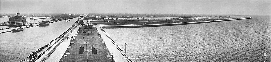
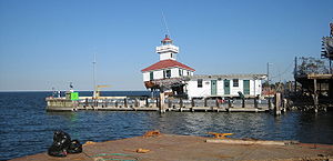 The Canal joined with Lake Pontchartrain around the present day intersection of Robert E. Lee and West End Boulevards, but jetties were added on both sides extending into the lake, one with a lighthouse
standing on the far end. From the lake the canal headed south through the swamp, cut through the highground of Metairie Ridge, through the mid-city lowlands, into the city, ended in a turning-basin at Rampart Street & Howard Avenue in what is now the New Orleans Central Business District
.
The canal was commercially important through the 19th century, and served additional uses as improving drainage in nearby areas and being used to harvest the bald cypress trees in what is now the Lakeview neighborhood, which were brought in to the city near the river via the canal and used to build many Uptown houses.
The importance of the canal declined after World War I
, especially with the opening of the Industrial Canal
in 1923. In 1936 the Louisiana Legislature passed a state constitutional amendment to close the canal. In 1937-1938 the area back to Claiborne Avenue was filled in, but the rest of the length continued functioning on a more limited scale until after World War II
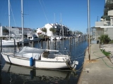
. The rest was filled in by about 1950, except for a half mile long stretch at the lakefront by the lighthouse which was left as a small boat and yachting harbor and continues to exist.
Much of the route became the Pontchartrain Expressway
in the 1950s, which was incorporated into I-10
the following decade. The stretch from the Interstate to Robert E Lee became a long narrow park by West End Boulevard. On November 4, 1990 the Irish Cultural Society of New Orleans dedicated a large Kilkenny
marble Celtic cross
in the park to commemorate the Irish workers who constructed the canal.
The lighthouse that stands at the entrance to the canal, which is on the National Register of Historic Places
, was heavily damaged during the 2005 hurricane season
. By the end of hurricane season the first floor had collapsed and its cupola
had fallen off.
In 2006 the Lake Pontchartrain
Basin Foundation signed a lease with the United States Coast Guard
to repair the damaged lighthouse.
Shipping
Shipping has multiple meanings. It can be a physical process of transporting commodities and merchandise goods and cargo, by land, air, and sea. It also can describe the movement of objects by ship.Land or "ground" shipping can be by train or by truck...
canal
Canal
Canals are man-made channels for water. There are two types of canal:#Waterways: navigable transportation canals used for carrying ships and boats shipping goods and conveying people, further subdivided into two kinds:...
in New Orleans, Louisiana
New Orleans, Louisiana
New Orleans is a major United States port and the largest city and metropolitan area in the state of Louisiana. The New Orleans metropolitan area has a population of 1,235,650 as of 2009, the 46th largest in the USA. The New Orleans – Metairie – Bogalusa combined statistical area has a population...
from the 1830s through the 1940s.
United States dollar
The United States dollar , also referred to as the American dollar, is the official currency of the United States of America. It is divided into 100 smaller units called cents or pennies....
s. The intent was to build a shipping canal from Lake Pontchartrain
Lake Pontchartrain
Lake Pontchartrain is a brackish estuary located in southeastern Louisiana. It is the second-largest inland saltwater body of water in the United States, after the Great Salt Lake in Utah, and the largest lake in Louisiana. As an estuary, Pontchartrain is not a true lake.It covers an area of with...
through the swamp
Swamp
A swamp is a wetland with some flooding of large areas of land by shallow bodies of water. A swamp generally has a large number of hammocks, or dry-land protrusions, covered by aquatic vegetation, or vegetation that tolerates periodical inundation. The two main types of swamp are "true" or swamp...
land to the booming Uptown
Uptown New Orleans
Uptown is a section of New Orleans, Louisiana on the East Bank of the Mississippi River encompassing a number of neighborhoods between the French Quarter and the Jefferson Parish line. It remains an area of mixed residential and small commercial properties, with a wealth of 19th century architecture...
or "American" section of the city, to compete with the existing Carondelet Canal
Carondelet Canal
The Carondelet Canal, also known as the Old Basin Canal, was a canal in New Orleans, Louisiana from 1794 through 1938.Construction of the canal began in June of 1794 on the orders of Governor of Louisiana Francisco Luis Hector de Carondelet, for whom the canal was named. The 1.6‑mile long canal...
in the Downtown
Downtown New Orleans
In New Orleans, Louisiana, USA, "downtown" has historically referred to neighborhoods along the Mississippi River down-river from Canal Street, including the French Quarter, Treme, Faubourg Marigny, Bywater, the 9th Ward, and other neighborhoods...
Creole
Louisiana Creole people
Louisiana Creole people refers to those who are descended from the colonial settlers in Louisiana, especially those of French and Spanish descent. The term was first used during colonial times by the settlers to refer to those who were born in the colony, as opposed to those born in the Old World...
part of the city. Work commenced the following year. Yellow fever
Yellow fever
Yellow fever is an acute viral hemorrhagic disease. The virus is a 40 to 50 nm enveloped RNA virus with positive sense of the Flaviviridae family....
ravaged workers in the swamp in back of the town, and the loss of slaves
Slavery
Slavery is a system under which people are treated as property to be bought and sold, and are forced to work. Slaves can be held against their will from the time of their capture, purchase or birth, and deprived of the right to leave, to refuse to work, or to demand compensation...
was judged too expensive, so most of the work was done by Irish
Ireland
Ireland is an island to the northwest of continental Europe. It is the third-largest island in Europe and the twentieth-largest island on Earth...
immigrant laborers. The Irish workers died in great numbers, but the Company had no trouble finding more workers to take their place, as shiploads of poor Irishmen arrived in New Orleans, and many were willing to risk their lives in hazardous backbreaking work for a chance to earn $1 a day. By 1838, after an expense of $1million, the 60 feet (18.3 m) wide 3.17 miles (5.1 km) long canal was complete enough to be opened to small vessels drawing 6 feet (1.8 m), with $0.375 per ton charged for passage. Over the next decade the canal was enlarged to 12 feet (3.7 m) deep, 100 feet (30.5 m) wide, and with shell roads alongside. No official count was kept of the deaths of the immigrant workers; estimates ranging from 4,000 to 30,000 have been published, with most historical best guesses falling in the 8,000 to 20,000 dead range. Many were buried with no marking in the levee and roadway fill beside the canal.
Lighthouse
A lighthouse is a tower, building, or other type of structure designed to emit light from a system of lamps and lenses or, in older times, from a fire, and used as an aid to navigation for maritime pilots at sea or on inland waterways....
standing on the far end. From the lake the canal headed south through the swamp, cut through the highground of Metairie Ridge, through the mid-city lowlands, into the city, ended in a turning-basin at Rampart Street & Howard Avenue in what is now the New Orleans Central Business District
New Orleans Central Business District
The Central Business District is a neighborhood of the city of New Orleans. A subdistrict of the French Quarter/CBD Area, its boundaries as defined by the City Planning Commission are: Iberville, Decatur and Canal Streets to the north, the Mississippi River to the east, the New Orleans Morial...
.
The canal was commercially important through the 19th century, and served additional uses as improving drainage in nearby areas and being used to harvest the bald cypress trees in what is now the Lakeview neighborhood, which were brought in to the city near the river via the canal and used to build many Uptown houses.
The importance of the canal declined after World War I
World War I
World War I , which was predominantly called the World War or the Great War from its occurrence until 1939, and the First World War or World War I thereafter, was a major war centred in Europe that began on 28 July 1914 and lasted until 11 November 1918...
, especially with the opening of the Industrial Canal
Industrial Canal
The Industrial Canal is a 5.5 mile waterway in New Orleans, Louisiana, United States. The waterway's proper name, as used by the U.S. Army Corps of Engineers and on NOAA nautical charts, is Inner Harbor Navigation Canal...
in 1923. In 1936 the Louisiana Legislature passed a state constitutional amendment to close the canal. In 1937-1938 the area back to Claiborne Avenue was filled in, but the rest of the length continued functioning on a more limited scale until after World War II
World War II
World War II, or the Second World War , was a global conflict lasting from 1939 to 1945, involving most of the world's nations—including all of the great powers—eventually forming two opposing military alliances: the Allies and the Axis...
. The rest was filled in by about 1950, except for a half mile long stretch at the lakefront by the lighthouse which was left as a small boat and yachting harbor and continues to exist.
Much of the route became the Pontchartrain Expressway
Pontchartrain Expressway
The Pontchartrain Expressway is a parallel 6-lane section of Interstate 10 and U.S. Route 90 in New Orleans, Louisiana. The designation begins on I-10 near the Orleans Parish/Jefferson Parish line at the I-610 Split. The expressway follows I-10 into the Central Business District of New Orleans ...
in the 1950s, which was incorporated into I-10
Interstate 10 in Louisiana
Interstate 10, a major transcontinental Interstate Highway in the Southern U.S., runs across the southern part of the U.S. state of Louisiana. It passes through Lake Charles, Lafayette and Baton Rouge before dipping south of Lake Pontchartrain to serve the New Orleans area and then passing through...
the following decade. The stretch from the Interstate to Robert E Lee became a long narrow park by West End Boulevard. On November 4, 1990 the Irish Cultural Society of New Orleans dedicated a large Kilkenny
Kilkenny
Kilkenny is a city and is the county town of the eponymous County Kilkenny in Ireland. It is situated on both banks of the River Nore in the province of Leinster, in the south-east of Ireland...
marble Celtic cross
Celtic cross
A Celtic cross is a symbol that combines a cross with a ring surrounding the intersection. In the Celtic Christian world it was combined with the Christian cross and this design was often used for high crosses – a free-standing cross made of stone and often richly decorated...
in the park to commemorate the Irish workers who constructed the canal.
The lighthouse that stands at the entrance to the canal, which is on the National Register of Historic Places
National Register of Historic Places
The National Register of Historic Places is the United States government's official list of districts, sites, buildings, structures, and objects deemed worthy of preservation...
, was heavily damaged during the 2005 hurricane season
2005 Atlantic hurricane season
The 2005 Atlantic hurricane season was the most active Atlantic hurricane season in recorded history, repeatedly shattering numerous records. The impact of the season was widespread and ruinous with an estimated 3,913 deaths and record damage of about $159.2 billion...
. By the end of hurricane season the first floor had collapsed and its cupola
Cupola
In architecture, a cupola is a small, most-often dome-like, structure on top of a building. Often used to provide a lookout or to admit light and air, it usually crowns a larger roof or dome....
had fallen off.
In 2006 the Lake Pontchartrain
Lake Pontchartrain
Lake Pontchartrain is a brackish estuary located in southeastern Louisiana. It is the second-largest inland saltwater body of water in the United States, after the Great Salt Lake in Utah, and the largest lake in Louisiana. As an estuary, Pontchartrain is not a true lake.It covers an area of with...
Basin Foundation signed a lease with the United States Coast Guard
United States Coast Guard
The United States Coast Guard is a branch of the United States Armed Forces and one of the seven U.S. uniformed services. The Coast Guard is a maritime, military, multi-mission service unique among the military branches for having a maritime law enforcement mission and a federal regulatory agency...
to repair the damaged lighthouse.