

Pontchartrain Expressway
Encyclopedia
The Pontchartrain Expressway is a parallel 6-lane section of Interstate 10
and U.S. Route 90
in New Orleans, Louisiana. The designation begins on I-10 near the Orleans Parish/Jefferson Parish
line at the I-610
Split. The expressway follows I-10 into the Central Business District
(CBD) of New Orleans (by the Superdome
) and then follows Business U.S. Route 90
to the Crescent City Connection
. The expressway takes its name from Pontchartrain Boulevard, for which the expressway overtook in some areas. The Pontchartrain name is derived from Lake Pontchartrain
, which New Orleans' northern border traverses.
; this is where the expressway designation begins. At the vicinity of West End Boulevard/Florida Avenue exit, the expressway turns to the southeast along the right-of-way for the former New Basin Canal
which had been filled in between 1937 and 1947. The expressway continues along this right-of-way as I-10 until a stack interchange
with U.S. 90 (Claiborne Avenue) in the CBD.
At this interchange, I-10 breaks off to the northeast and Business U.S. 90 begins. The expressway continues southeast along the upriver side of the CBD as an elevated highway that leads to the Crescent City Connection
. This section was completed by 1958 opening of the Crescent City Connection.
The Business U.S. 90 portion of the expressway was expanded in the mid 1980s to accommodate the second span of the Crescent City Connection which opened in 1988. This stretch of the expressway and the stack interchange of I-10 and U.S. 90 received further reconstruction in the early 1990s, including two reversible HOV
lanes that stretch from the intersection of Earhart Boulevard and Magnolia Street (underneath the Pontchartrain Expressway) across the Crescent City Connection to the Westbank Expressway
. Reconstruction of the northern end of the expressway in the I-610 Split vicinity was undertaken in the late 1990s. Also in the late 1990s, further work was done on the expressway as three ramps were constructed, one connecting East Business U.S. 90 to East I-10 and the others connecting West I-10 to West Business U.S. 90 and westbound Claiborne Avenue (West US 90).
The Norfolk Southern Railway
has an overpass crossing near the Metairie Cemetery
between the City Park Avenue and West End Boulevard/Florida Avenue exits. The expressway dips down to 12 feet (3.7 m) below sea level to allow for the rail line to pass overhead. This area once experienced flooding on a regular basis in heavy thunderstorms and tropical systems. The problem was so common, a depth meter was painted on the overpass support columns to warn drivers of the water's depth. A new pumping station was completed adjacent to the expressway in 2004 to keep this area dry and allow the interstate to remain open in the event of an evacuation.
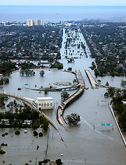 In the aftermath of Hurricane Katrina
, this pumping station was overwhelmed and the railroad underpass and the entire I-610/West End Boulevard interchange was extensively flooded. In fact, the 17th Street Canal
breach is about one mile (1.6 km) north of this area. This flooding cut Orleans Parish off from most areas to the west, making the Crescent City Connection one of the few clear routes into the eastbank of Orleans Parish. Areas under the elevated portions of the expressway in the CBD area saw flooding in the vicinity of the Superdome but for the most part remained dry and undamaged. Some evacuaees trapped in the city for days after Katrina attempted to use the expressway and the Crescent City Connection to walk to dry ground on the West Bank.
, however it is not signed as such. This is a temporary designation that overlaps all freeway portions of Business U.S. 90 (the Pontchartrain Expressway, Crescent City Connection, and Westbank Expressway). When Interstate 49
is completed from Lafayette
to New Orleans, Business U.S. 90/Interstate 910 will be resigned as Interstate 49.
Interstate 10
Interstate 10 is the fourth-longest Interstate Highway in the United States, after I-90, I-80, and I-40. It is the southernmost east–west, coast-to-coast Interstate Highway, although I-4 and I-8 are further south. It stretches from the Pacific Ocean at State Route 1 in Santa Monica,...
and U.S. Route 90
U.S. Route 90
U.S. Route 90 is an east–west United States highway. Despite the "0" in its route number, U.S. 90 never was a full coast-to-coast route; it has always ended at Van Horn, Texas. A short-lived northward extension to U.S...
in New Orleans, Louisiana. The designation begins on I-10 near the Orleans Parish/Jefferson Parish
Jefferson Parish, Louisiana
Jefferson Parish is a parish in Louisiana, United States that includes most of the suburbs of New Orleans. The seat of parish government is Gretna....
line at the I-610
Interstate 610 (Louisiana)
Interstate 610 is a long auxiliary route of Interstate 10 that lies entirely within the boundaries of New Orleans, Louisiana.-Route description:...
Split. The expressway follows I-10 into the Central Business District
New Orleans Central Business District
The Central Business District is a neighborhood of the city of New Orleans. A subdistrict of the French Quarter/CBD Area, its boundaries as defined by the City Planning Commission are: Iberville, Decatur and Canal Streets to the north, the Mississippi River to the east, the New Orleans Morial...
(CBD) of New Orleans (by the Superdome
Louisiana Superdome
The Mercedes-Benz Superdome, previously known as the Louisiana Superdome and colloquially known as the Superdome, is a sports and exhibition arena located in the Central Business District of New Orleans, Louisiana, USA...
) and then follows Business U.S. Route 90
U.S. Route 90 Business (New Orleans, Louisiana)
U.S. Highway 90 Business is a business route of U.S. Highway 90 in and near New Orleans, Louisiana, United States. Unlike a standard business route, it is built to higher standards than the segment of U.S. 90 that it parallels, with over half built to freeway standards and designated Interstate 910...
to the Crescent City Connection
Crescent City Connection
The Crescent City Connection, abbreviated as CCC, refers to twin cantilever bridges that carry U.S. Route 90 Business over the Mississippi River in New Orleans, Louisiana, United States. They are tied as the fifth-longest cantilever bridges in the world...
. The expressway takes its name from Pontchartrain Boulevard, for which the expressway overtook in some areas. The Pontchartrain name is derived from Lake Pontchartrain
Lake Pontchartrain
Lake Pontchartrain is a brackish estuary located in southeastern Louisiana. It is the second-largest inland saltwater body of water in the United States, after the Great Salt Lake in Utah, and the largest lake in Louisiana. As an estuary, Pontchartrain is not a true lake.It covers an area of with...
, which New Orleans' northern border traverses.
History
Construction of the Pontchartrain Expressway began in the 1950s. It would later be incorporated into Interstate 10. I-10 enters Orleans Parish after crossing the 17th Street Canal17th Street Canal
The 17th Street Canal is a drainage canal in Greater New Orleans, Louisiana, that flows into Lake Pontchartrain. The canal forms a significant portion of the boundary between the city of New Orleans and Metairie, Louisiana...
; this is where the expressway designation begins. At the vicinity of West End Boulevard/Florida Avenue exit, the expressway turns to the southeast along the right-of-way for the former New Basin Canal
New Basin Canal
The New Basin Canal, also known as the New Orleans Canal and the New Canal, was a shipping canal in New Orleans, Louisiana from the 1830s through the 1940s....
which had been filled in between 1937 and 1947. The expressway continues along this right-of-way as I-10 until a stack interchange
Stack interchange
A stack interchange is a free-flowing grade separated junction between two roads.In countries where one drives on the right, left turns are handled by semi-directional flyover/under ramps...
with U.S. 90 (Claiborne Avenue) in the CBD.
At this interchange, I-10 breaks off to the northeast and Business U.S. 90 begins. The expressway continues southeast along the upriver side of the CBD as an elevated highway that leads to the Crescent City Connection
Crescent City Connection
The Crescent City Connection, abbreviated as CCC, refers to twin cantilever bridges that carry U.S. Route 90 Business over the Mississippi River in New Orleans, Louisiana, United States. They are tied as the fifth-longest cantilever bridges in the world...
. This section was completed by 1958 opening of the Crescent City Connection.
The Business U.S. 90 portion of the expressway was expanded in the mid 1980s to accommodate the second span of the Crescent City Connection which opened in 1988. This stretch of the expressway and the stack interchange of I-10 and U.S. 90 received further reconstruction in the early 1990s, including two reversible HOV
High-occupancy vehicle lane
In transportation engineering and transportation planning, a high-occupancy vehicle lane is a lane reserved for vehicles with a driver and one or more passengers...
lanes that stretch from the intersection of Earhart Boulevard and Magnolia Street (underneath the Pontchartrain Expressway) across the Crescent City Connection to the Westbank Expressway
U.S. Route 90 Business (New Orleans, Louisiana)
U.S. Highway 90 Business is a business route of U.S. Highway 90 in and near New Orleans, Louisiana, United States. Unlike a standard business route, it is built to higher standards than the segment of U.S. 90 that it parallels, with over half built to freeway standards and designated Interstate 910...
. Reconstruction of the northern end of the expressway in the I-610 Split vicinity was undertaken in the late 1990s. Also in the late 1990s, further work was done on the expressway as three ramps were constructed, one connecting East Business U.S. 90 to East I-10 and the others connecting West I-10 to West Business U.S. 90 and westbound Claiborne Avenue (West US 90).
The Norfolk Southern Railway
Norfolk Southern Railway
The Norfolk Southern Railway is a Class I railroad in the United States, owned by the Norfolk Southern Corporation. With headquarters in Norfolk, Virginia, the company operates 21,500 route miles in 22 eastern states, the District of Columbia and the province of Ontario, Canada...
has an overpass crossing near the Metairie Cemetery
Metairie Cemetery
Metairie Cemetery is a cemetery in New Orleans, Louisiana, United States. The name has caused some people to mistakenly presume that the cemetery is located in Metairie, Louisiana, but it is located within the New Orleans city limits, on Metairie Road .-History:This site was previously a horse...
between the City Park Avenue and West End Boulevard/Florida Avenue exits. The expressway dips down to 12 feet (3.7 m) below sea level to allow for the rail line to pass overhead. This area once experienced flooding on a regular basis in heavy thunderstorms and tropical systems. The problem was so common, a depth meter was painted on the overpass support columns to warn drivers of the water's depth. A new pumping station was completed adjacent to the expressway in 2004 to keep this area dry and allow the interstate to remain open in the event of an evacuation.
Hurricane Katrina
Hurricane Katrina
Hurricane Katrina of the 2005 Atlantic hurricane season was a powerful Atlantic hurricane. It is the costliest natural disaster, as well as one of the five deadliest hurricanes, in the history of the United States. Among recorded Atlantic hurricanes, it was the sixth strongest overall...
, this pumping station was overwhelmed and the railroad underpass and the entire I-610/West End Boulevard interchange was extensively flooded. In fact, the 17th Street Canal
17th Street Canal
The 17th Street Canal is a drainage canal in Greater New Orleans, Louisiana, that flows into Lake Pontchartrain. The canal forms a significant portion of the boundary between the city of New Orleans and Metairie, Louisiana...
breach is about one mile (1.6 km) north of this area. This flooding cut Orleans Parish off from most areas to the west, making the Crescent City Connection one of the few clear routes into the eastbank of Orleans Parish. Areas under the elevated portions of the expressway in the CBD area saw flooding in the vicinity of the Superdome but for the most part remained dry and undamaged. Some evacuaees trapped in the city for days after Katrina attempted to use the expressway and the Crescent City Connection to walk to dry ground on the West Bank.
Interstates 49 and 910
The Business U.S. 90 portion of the Pontchartrain Expressway is also designated as Interstate 910U.S. Route 90 Business (New Orleans, Louisiana)
U.S. Highway 90 Business is a business route of U.S. Highway 90 in and near New Orleans, Louisiana, United States. Unlike a standard business route, it is built to higher standards than the segment of U.S. 90 that it parallels, with over half built to freeway standards and designated Interstate 910...
, however it is not signed as such. This is a temporary designation that overlaps all freeway portions of Business U.S. 90 (the Pontchartrain Expressway, Crescent City Connection, and Westbank Expressway). When Interstate 49
Interstate 49
Interstate 49 is currently an intrastate Interstate Highway located entirely within the state of Louisiana in the southern United States. Its southern terminus is in Lafayette, Louisiana, at Interstate 10 while its northern terminus is in Shreveport, Louisiana, at Interstate 20.-Route...
is completed from Lafayette
Lafayette, Louisiana
Lafayette is a city in and the parish seat of Lafayette Parish, Louisiana, United States, on the Vermilion River. The population was 120,623 at the 2010 census...
to New Orleans, Business U.S. 90/Interstate 910 will be resigned as Interstate 49.