
Nandewar Range
Encyclopedia
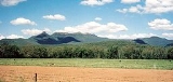
The Nandewar Range is a mountain range
30 km (18.6 mi) east of Narrabri
in New South Wales
, Australia
. John Oxley
was the first European to see the range in 1818 as he explored the New South Wales Northern Tablelands
.
The range is located on the western, inland, side of the New England
region, and generally forms the watershed divide between the Namoi River
and Gwydir River
catchment basins to the south and north respectively. The Macdonald River
starting south of Walcha
drains west to Warrabah National Park
where it changes its name to the Namoi then is added to by the Manilla River
, Peel River
and Mooki River
. The Horton River runs north to the Gwydir. Both rivers together drain large segments of the Nandewar Range.
The eastern part of the Nandewar Range starts at the Great Dividing Range
south of Uralla. As this is already in the Northern Tablelands
of New South Wales
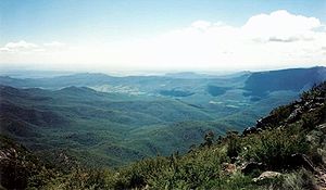
it is low, hilly and not particularly distinctive. The main road between Barraba and Bingara crosses the range. At its western end, however, the Nandewar Range culminates at Mount Kaputar
, a complex of volcanic origin, from which spectacular views of the flat inland plains of New South Wales can be seen.
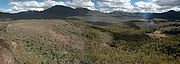
 Small patches of rainforest mark the western limit of some tree species. The foothill areas of the Nandewar Range are used for grazing and cropping. There are forests in some of the higher areas. The Mount Kaputar area is included in Mount Kaputar National Park
.
 The range is occasionally dusted with light snow in winter.
ic shield volcano
that formed about 18 million years ago. Some of the exposed rocks in the area are 230 million years old.
Mountain range
A mountain range is a single, large mass consisting of a succession of mountains or narrowly spaced mountain ridges, with or without peaks, closely related in position, direction, formation, and age; a component part of a mountain system or of a mountain chain...
30 km (18.6 mi) east of Narrabri
Narrabri, New South Wales
Narrabri is a town and seat of Narrabri Shire Council Local Government Area in the North West Slopes, New South Wales, Australia. Narrabri is situated on the Namoi River and lies northwest of Sydney. It sits on the junction of the Kamilaroi Highway and the Newell Highway...
in New South Wales
New South Wales
New South Wales is a state of :Australia, located in the east of the country. It is bordered by Queensland, Victoria and South Australia to the north, south and west respectively. To the east, the state is bordered by the Tasman Sea, which forms part of the Pacific Ocean. New South Wales...
, Australia
Australia
Australia , officially the Commonwealth of Australia, is a country in the Southern Hemisphere comprising the mainland of the Australian continent, the island of Tasmania, and numerous smaller islands in the Indian and Pacific Oceans. It is the world's sixth-largest country by total area...
. John Oxley
John Oxley
John Joseph William Molesworth Oxley was an explorer and surveyor of Australia in the early period of English colonisation.October 1802 he was engaged in coastal survey work including an expedition to Western Port in 1804-05...
was the first European to see the range in 1818 as he explored the New South Wales Northern Tablelands
Northern Tablelands, New South Wales
The Northern Tablelands, also known as the New England Tableland, is a plateau and a region of the Great Dividing Range in northern New South Wales, Australia. It includes the New England Range, the narrow highlands area of the New England region, stretching from the Moonbi Range in the south to...
.
The range is located on the western, inland, side of the New England
New England (Australia)
New England or New England North West is the name given to a generally undefined region about 60 kilometres inland, that includes the Northern Tablelands and the North West Slopes regions in the north of the state of New South Wales, Australia.-History:The region has been occupied by Indigenous...
region, and generally forms the watershed divide between the Namoi River
Namoi River
The Namoi River is a major tributary of the Darling River in inland New South Wales, Australia.- Course :The headwaters of the Namoi, including the Macdonald River, the Peel River, the Cockburn River and the Manilla River, rise on the western slopes of the Great Dividing Range on the Northern...
and Gwydir River
Gwydir River
The Gwydir River is a large inland river in the northern part of the Australian state of New South Wales which is part of the Murray-Darling Basin. The river has two main tributaries—the Horton River and the Rocky River...
catchment basins to the south and north respectively. The Macdonald River
Macdonald River (Bendemeer)
There are two rivers named Macdonald River in New South Wales, Australia. See Macdonald RiverThe Macdonald River in northern New South Wales is the headwater of the Namoi River. It rises east of Niangala on the western slopes of the Great Dividing Range on the Northern Tablelands, New South Wales...
starting south of Walcha
Walcha
Walcha can refer to* Walcha, a town and Local Government Area in the north of New South Wales, Australia.* the German organist Helmut Walcha...
drains west to Warrabah National Park
Warrabah National Park
Warrabah is a national park in New South Wales, Australia, 371 km north of Sydney. It is situated west of Kingstown and east of Split Rock Dam....
where it changes its name to the Namoi then is added to by the Manilla River
Manilla River
The Manilla River is a tributary of the Namoi River in northern New South Wales, Australia. Despite the name, it is officially classified as a stream by the Geographical Names Board of New South Wales....
, Peel River
Peel River (New South Wales)
The Peel River is a river in New South Wales, Australia. It is part of the Murray-Darling Basin.The Peel rises on the northern slopes of the Liverpool Range south of the village of Nundle. It flows generally north and west through the foothills of the Great Dividing Range, through Woolomin and...
and Mooki River
Mooki River
The Mooki River is a river in northern New South Wales, Australia.The Mooki River is the main river of the western half of the Liverpool Plains. Its headwaters rise on the northern slopes of the Liverpool Range and Coolah Tops, and flow northwards....
. The Horton River runs north to the Gwydir. Both rivers together drain large segments of the Nandewar Range.
The eastern part of the Nandewar Range starts at the Great Dividing Range
Great Dividing Range
The Great Dividing Range, or the Eastern Highlands, is Australia's most substantial mountain range and the third longest in the world. The range stretches more than 3,500 km from Dauan Island off the northeastern tip of Queensland, running the entire length of the eastern coastline through...
south of Uralla. As this is already in the Northern Tablelands
Northern Tablelands, New South Wales
The Northern Tablelands, also known as the New England Tableland, is a plateau and a region of the Great Dividing Range in northern New South Wales, Australia. It includes the New England Range, the narrow highlands area of the New England region, stretching from the Moonbi Range in the south to...
of New South Wales
New South Wales
New South Wales is a state of :Australia, located in the east of the country. It is bordered by Queensland, Victoria and South Australia to the north, south and west respectively. To the east, the state is bordered by the Tasman Sea, which forms part of the Pacific Ocean. New South Wales...
it is low, hilly and not particularly distinctive. The main road between Barraba and Bingara crosses the range. At its western end, however, the Nandewar Range culminates at Mount Kaputar
Mount Kaputar
Mount Kaputar is a mountain near Narrabri in northern New South Wales. It is part of the Nandewar Range and has been preserved within the Mount Kaputar National Park. The mountain is a prominent landmark for travellers on the Newell Highway as it rises abruptly from the plains...
, a complex of volcanic origin, from which spectacular views of the flat inland plains of New South Wales can be seen.
Mount Kaputar National Park
Mount Kaputar National Park is a national park in Australia, surrounding the proximities of Mount Kaputar, a volcano active between 17 and 21 million years ago. It is located east of Narrabri and northwest of Sydney. Millions of years of erosion have since carved the volcanic region into the...
.
Geology
The range is the remnants of an eroded basaltBasalt
Basalt is a common extrusive volcanic rock. It is usually grey to black and fine-grained due to rapid cooling of lava at the surface of a planet. It may be porphyritic containing larger crystals in a fine matrix, or vesicular, or frothy scoria. Unweathered basalt is black or grey...
ic shield volcano
Shield volcano
A shield volcano is a type of volcano usually built almost entirely of fluid lava flows. They are named for their large size and low profile, resembling a warrior's shield. This is caused by the highly fluid lava they erupt, which travels farther than lava erupted from more explosive volcanoes...
that formed about 18 million years ago. Some of the exposed rocks in the area are 230 million years old.
Peaks
Mountains within the Nandewar Range include;- Bushy MountainBushy MountainBushy Mountain is a mountain east of Narrabri in northern New South Wales. It is part of the Nandewar Range and has been preserved within the Mount Kaputar National Park....
- Castletop Mountain
- Gins Mountain
- Grattai MountainGrattai MountainGrattai Mountain is a located in the Nandewar Range, in northern New South Wales, Australia. It was formed around 21 million years ago, by the Nandewar Volcano. The mountain is protected in the Mount Kaputar National Park. It is rarely climbed due to its isolation, lack of walking tracks and the...
- Mount Dowe
- Mount KaputarMount KaputarMount Kaputar is a mountain near Narrabri in northern New South Wales. It is part of the Nandewar Range and has been preserved within the Mount Kaputar National Park. The mountain is a prominent landmark for travellers on the Newell Highway as it rises abruptly from the plains...
- Mount Lawler
- Mount Lindesay
- Mount NingadhunMount NingadhunMount Ningadhun is a mountain east of Narrabri in northern New South Wales. It is part of the Nandewar Range and has been preserved within the Mount Kaputar National Park....
- Mount Waa
- Mount Yulludunida
- Round Mountain