
Mount Kaputar
Encyclopedia
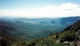
Mount Kaputar is a mountain
near Narrabri
in northern New South Wales
. It is part of the Nandewar Range
and has been preserved within the Mount Kaputar National Park
. The mountain is a prominent landmark
for travellers on the Newell Highway
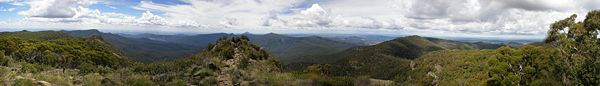
as it rises abruptly from the plains. It is claimed that on a clear day roughly one seventh of New South Wales is visible from the top of the mountain. In the cold of winter the mountain may receive a light dusting of snow
.
The summit is accessible from Narrabri via a 57 km long, winding and narrow road that is partly sealed. Neighbouring Mount Dowe (also about 1,500 m elevation) contains various telecommunications broadcasting equipment and the large antenna is visible from the Kamilaroi Highway
heading south towards Gunnedah.
There is a lookout at the top of the peak called Mount Kaputar Lookout. Nearby is the Governor Lookout and Eckfords Lookout as well as Dawson Spring with cabins, picnic tables and camping facilities.
Mount Kaputar is the remnants of an extinct volcano that was active about 18 million years ago. Mount Lindesay was probably the centre of the volcano. The predominant vegetation on the mountain is dry sclerophyll
forest.
Mountain
Image:Himalaya_annotated.jpg|thumb|right|The Himalayan mountain range with Mount Everestrect 58 14 160 49 Chomo Lonzorect 200 28 335 52 Makalurect 378 24 566 45 Mount Everestrect 188 581 920 656 Tibetan Plateaurect 250 406 340 427 Rong River...
near Narrabri
Narrabri, New South Wales
Narrabri is a town and seat of Narrabri Shire Council Local Government Area in the North West Slopes, New South Wales, Australia. Narrabri is situated on the Namoi River and lies northwest of Sydney. It sits on the junction of the Kamilaroi Highway and the Newell Highway...
in northern New South Wales
New South Wales
New South Wales is a state of :Australia, located in the east of the country. It is bordered by Queensland, Victoria and South Australia to the north, south and west respectively. To the east, the state is bordered by the Tasman Sea, which forms part of the Pacific Ocean. New South Wales...
. It is part of the Nandewar Range
Nandewar Range
The Nandewar Range is a mountain range east of Narrabri in New South Wales, Australia. John Oxley was the first European to see the range in 1818 as he explored the New South Wales Northern Tablelands....
and has been preserved within the Mount Kaputar National Park
Mount Kaputar National Park
Mount Kaputar National Park is a national park in Australia, surrounding the proximities of Mount Kaputar, a volcano active between 17 and 21 million years ago. It is located east of Narrabri and northwest of Sydney. Millions of years of erosion have since carved the volcanic region into the...
. The mountain is a prominent landmark
Landmark
This is a list of landmarks around the world.Landmarks may be split into two categories - natural phenomena and man-made features, like buildings, bridges, statues, public squares and so forth...
for travellers on the Newell Highway
Newell Highway
The Newell Highway is the longest highway in New South Wales, Australia. It runs parallel to the eastern coast about 400 kilometres inland, and is the main inland direct road link from Victoria to Queensland, bypassing the more congested coastal areas of New South Wales...
as it rises abruptly from the plains. It is claimed that on a clear day roughly one seventh of New South Wales is visible from the top of the mountain. In the cold of winter the mountain may receive a light dusting of snow
Snow
Snow is a form of precipitation within the Earth's atmosphere in the form of crystalline water ice, consisting of a multitude of snowflakes that fall from clouds. Since snow is composed of small ice particles, it is a granular material. It has an open and therefore soft structure, unless packed by...
.
The summit is accessible from Narrabri via a 57 km long, winding and narrow road that is partly sealed. Neighbouring Mount Dowe (also about 1,500 m elevation) contains various telecommunications broadcasting equipment and the large antenna is visible from the Kamilaroi Highway
Kamilaroi Highway
Kamilaroi Highway is a state highway in New South Wales. It has been given the national route number 37. Its status as a highway is fairly new....
heading south towards Gunnedah.
There is a lookout at the top of the peak called Mount Kaputar Lookout. Nearby is the Governor Lookout and Eckfords Lookout as well as Dawson Spring with cabins, picnic tables and camping facilities.
Mount Kaputar is the remnants of an extinct volcano that was active about 18 million years ago. Mount Lindesay was probably the centre of the volcano. The predominant vegetation on the mountain is dry sclerophyll
Sclerophyll
Sclerophyll is the term for a type of vegetation that has hard leaves and short internodes . The word comes from the Greek sclero and phyllon ....
forest.
See also
- Grattai MountainGrattai MountainGrattai Mountain is a located in the Nandewar Range, in northern New South Wales, Australia. It was formed around 21 million years ago, by the Nandewar Volcano. The mountain is protected in the Mount Kaputar National Park. It is rarely climbed due to its isolation, lack of walking tracks and the...
- List of mountains in Australia
- List of volcanoes in Australia
External links
- Weather station with webcam, Operated by Oz Forecast