
Myanmar Railways
Encyclopedia
- This article discusses Myanmar Railways, originally known as Burma Railways. For the article on the World War II railway between Thailand and Burma, see Burma Railway.
Myanmar Railways (MR) ; also spelled Myanma Railways; formerly Burma Railways) is the state-owned agency that operates the railway network in Myanmar
Myanmar
Burma , officially the Republic of the Union of Myanmar , is a country in Southeast Asia. Burma is bordered by China on the northeast, Laos on the east, Thailand on the southeast, Bangladesh on the west, India on the northwest, the Bay of Bengal to the southwest, and the Andaman Sea on the south....
. The 5403 kilometres (3,357 mi) metre gauge
Metre gauge
Metre gauge refers to narrow gauge railways and tramways with a track gauge of . In some African, American and Asian countries it is the main gauge. In Europe it has been used for local railways in France, Germany, and Belgium, most of which were closed down in mid 20th century. Only in Switzerland...
rail network consists of 858 stations, and generally spans north to south with branch lines to east and west. MR also operates the Yangon Circular Railway
Yangon Circular Railway
Yangon Circular Railway is the local commuter rail network that serves the Yangon metropolitan area. Operated by Myanmar Railways, the 39-station loop system connects satellite towns and suburban areas to the city. The railway has about 200 coaches, runs 20 times and sells 100,000 to 150,000...
line, Yangon's commuter rail network. MR operates 18 freight trains, and 379 passenger trains, transporting over 100,000 passengers daily.
The quality of the railroads is generally poor. Most remain in poor repair and are not passable during the monsoon season. The speeds of freight trains are heavily restricted on all existing links as a consequence of poor track and bridge conditions. The maximum speed for freight trains has been quoted as 24 km/h (14.9 mph), suggesting that commercial speeds on this section could be as low as 12 –.
MR has steadily increased the reach of its network in the last two decades, from nearly 3200 km in 1988 to 5403 km in 2010. MR is currently undertaking an ambitious expansion program that will add another 3645 km (2,265 mi) to its network, including extensions to Myeik in the south, Kyaingtong in the east, Sittwe
Sittwe
-Economy:In February 2007, India announced a plan to develop the port, which would enable ocean access from Indian Northeastern states, so called "Seven sisters", like Mizoram, via the Kaladan River....
in the west.
History
Rail transport was first introduced in Myanmar in May 1877 when Lower BurmaLower Burma
Lower Burma is a geographic region of Burma and includes the low-lying Irrawaddy delta , as well as coastal regions of the country ....
was a British
British Empire
The British Empire comprised the dominions, colonies, protectorates, mandates and other territories ruled or administered by the United Kingdom. It originated with the overseas colonies and trading posts established by England in the late 16th and early 17th centuries. At its height, it was the...
colony with the opening of the 163 miles (262 km) Yangon
Yangon
Yangon is a former capital of Burma and the capital of Yangon Region . Although the military government has officially relocated the capital to Naypyidaw since March 2006, Yangon, with a population of over four million, continues to be the country's largest city and the most important commercial...
to Pyay
Pyay
Pyay is a town in the Bago Division in Burma. It has an estimated population of 123,800 . Pyay is positioned on the Ayeyarwady River and is northwest of Yangon....
line by The Irrawaddy Valley State Railway. In 1884, a new company, The Sittang Valley State Railway, opened a 166 miles (267 km) line along the Sittaung River from Yangon to the town of Taungoo
Taungoo
-Administration:*Taungoo District Peace and Development Council - List of Six Townships*Taungoo Township Peace and Development Council*Taungoo Ward Peace and Development Council - 22 Wards*Taungoo Municipal*District and Township Immigration Dept...
via Bago. After the annexation of Upper Burma
Upper Burma
Upper Burma refers to a geographic region of Burma , traditionally encompassing Mandalay and its periphery , or more broadly speaking, Kachin and Shan States....
following the Third Anglo-Burmese War
Third Anglo-Burmese War
The Third Anglo-Burmese War was a conflict that took place during 7–29 November 1885, with sporadic resistance and insurgency continuing into 1887. It was the final of three wars fought in the 19th century between the Burmese and the British...
of 1885, the British extended the Taungoo line to Mandalay
Mandalay
Mandalay is the second-largest city and the last royal capital of Burma. Located north of Yangon on the east bank of the Irrawaddy River, the city has a population of one million, and is the capital of Mandalay Region ....
, the fallen capital, by 1889. Following the opening of this section, the Mu Valley State Railway was formed and construction began on a railway line from Sagaing
Sagaing
Sagaing is the capital of Sagaing Region in Myanmar. Located on the Ayeyarwady River, 20 km to the southwest of Mandalay on the opposite bank of the river, Sagaing with numerous Buddhist monasteries is an important religious and monastic center. The pagodas and monasteries crowd the numerous...
to Myitkyina
Myitkyina
Myitkyina is the capital city of Kachin State in Myanmar , located from Yangon, and from Mandalay. In Burmese it means "near the big river", and in fact "Myitkyina" lies on the west bank of the Ayeyarwady River, just below from Myit-son of its two headstreams...
and connected Mandalay to Shwebo
Shwebo
Shwebo is a city in Sagaing Division, Myanmar, located 113 km northwest of Mandalay between the Irrawaddy and the Mu rivers. The city, also called Ratanasingha , was the capital of Myanmar from 1752 to 1760 during the Konbaung period....
in 1891, to Wuntho
Wuntho, Burma
Wuntho is a town in Katha District, Sagaing Division, Burma . It is the administrative seat of Wuntho Township. While not the capital, it gave its name to the native state of Wuntho which was formally annexed to Burma by the British in 1892...
in 1893, to Katha
Katha
Katha may refer to:* The Sanskrit for "speech, narration, story, fable", see Katha * The Kaṭha or Caraka-Katha school of the Black Yajurveda** Katha Upanishad, a Hindu text associated with the Katha school...
in 1895, and to Myitkyina
Myitkyina
Myitkyina is the capital city of Kachin State in Myanmar , located from Yangon, and from Mandalay. In Burmese it means "near the big river", and in fact "Myitkyina" lies on the west bank of the Ayeyarwady River, just below from Myit-son of its two headstreams...
in 1898.
In 1896, before the completion of the line to Myitkyina, the three companies were combined into the Burma Railway Company as a state owned public undertaking. The railway was known as Burma Railways between 1928 and 1989. The railway's reach to the Taninthayi coast first came in 1907 with the opening of the Bago-Mottama line. Passengers had to take a ferry
Ferry
A ferry is a form of transportation, usually a boat, but sometimes a ship, used to carry primarily passengers, and sometimes vehicles and cargo as well, across a body of water. Most ferries operate on regular, frequent, return services...
over the Thanlwin River (Salween River) to Mawlamyaing. In 1942, the country had 3313 km (2,059 mi) (route-km) of metre gauge
Metre gauge
Metre gauge refers to narrow gauge railways and tramways with a track gauge of . In some African, American and Asian countries it is the main gauge. In Europe it has been used for local railways in France, Germany, and Belgium, most of which were closed down in mid 20th century. Only in Switzerland...
track, but during World War II
World War II
World War II, or the Second World War , was a global conflict lasting from 1939 to 1945, involving most of the world's nations—including all of the great powers—eventually forming two opposing military alliances: the Allies and the Axis...
the Japanese
Empire of Japan
The Empire of Japan is the name of the state of Japan that existed from the Meiji Restoration on 3 January 1868 to the enactment of the post-World War II Constitution of...
removed about 480 km (298 mi). By the end of the conflict only 1085 km (674 mi) (route-km) was operational, in four isolated sections. They constructed the only international link the country has enjoyed, from Thanbyusayat Junction via Three Pagodas Pass to Thailand, the short-lived Death Railway
Death Railway
The Burma Railway, also known as the Death Railway, the Thailand–Burma Railway and similar names, was a railway between Bangkok, Thailand, and Rangoon, Burma , built by the Empire of Japan during World War II, to support its forces in the Burma campaign.Forced labour was used in its construction...
.
After Myanmar gained independence from the UK in 1948, the rail network was rebuilt. By 1961 the network extended to 3020 km (1,877 mi), and then remained constant until the opening of a 36 km (22 mi) line from Kyaukpadaung to Kyini in October 1970. In 1988, MR operated 487 railway stations over a 3162 km (1,965 mi) long network. Since coming to power in 1988, the current military government
State Peace and Development Council
The State Peace and Development Council was the official name of the military regime of Burma , which seized power in 1988. On 30 March 2011, Senior General Than Shwe signed a decree to officially dissolve the Council....
has embarked on a railroad construction program, and by 2000 MR operated 5068 km (3,149 mi) (track-km) divided into 11 operating divisions. Most of the routes are single track
Single track (rail)
A single track railway is where trains in both directions share the same track. Single track is normally used on lesser used rail lines, often branch lines, where the traffic density is not high enough to justify the cost of building double tracks....
although large parts of Yangon-Pyay and Yangon-Mandalay routes are double track
Double track
A double track railway usually involves running one track in each direction, compared to a single track railway where trains in both directions share the same track.- Overview :...
.
Recent railroad expansion
1994 saw the start of construction of the initially isolated 160 km (99 mi) Ye-Dawei (Tavoy) railway, completed March 1998. This was later joined to the route north at Ye by the new 250 m (273.4 yd) road/rail bridge across the Ye RiverYe River
-See also:*List of rivers in Burma...
, opened November 2003. In April 2008, the tracks were extended across the 2.4 km (1.5 mi) Moulmein road/rail bridge, provision having been made in its design when it was opened a few years earlier. This allowed the long isolated section south to Ye and later Dawei (Tavoy) to receive trains from the north of the country. Also in 2008/9, the Ayeyawady Valley route was extended north along the west bank of the river towards Pakokku in the far north of the country. The 60 km (37.3 mi) Kyangin-Okshippin (Padang) section of Kyangin-Thayet railway was opened in March 2008 and the 56 km (34.8 mi) Okshippin-Kamma railway section was opened in March 2009.
In 2009, planning started on a link from Lashio
Lashio
Lashio is the largest town in northern Shan State, Myanmar, about northeast of Mandalay. It is situated on a low mountain spur overlooking the valley of the Nam Yao river. The population grew from around 5000 in 1960 to 88,590 in 1983. It is currently estimated at around 130,000.Lashio is the...
to Jiegao
Jiegao
Jiegao is a town in southern China near the border with Myanmar. It belongs to Yunnan province. It is near Ruili and Mengmao.- Geography :Jiegao is located with a river separating it with a finger of Myanmar land extending eastward.- Transport :...
in China. This links would have a - break-of-gauge
Break-of-gauge
With railways, a break-of-gauge occurs where a line of one gauge meets a line of a different gauge. Trains and rolling stock cannot run through without some form of conversion between gauges, and freight and passengers must otherwise be transloaded...
.
In 2010, MR is working on multiple railroad construction projects: Motagyi-Bhamo (130 km (80.8 mi)), Mongnai-Kyaingtong (346 km (215 mi)), Minbu-An-Yechanpyin (395 km (245.4 mi)), Dawei-Myeik (213 km (132.4 mi)), Pathein-Nyaungdon-Yangon Hlaingthaya (143 km (88.9 mi)), Pyay-Taungoo-Naypyidaw (193 km (119.9 mi)), Hinthada-Nyaungdon (77 km (47.8 mi)), Thayet-Kyunchaung (307 km (190.8 mi)), Ywataw-Kanpya (105 km (65.2 mi)).
Rail network and services
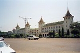
MR operates 858 stations throughout the country. Yangon CentralYangon Central Railway Station
Yangon Central Railway Station , located in downtown Yangon, is the largest railway station in Myanmar. It is the gateway to Myanmar Railways' 3,126-mile rail network whose reach covers Upper Myanmar , upcountry , Shan hills and the Taninthayi coast .The station was first built in 1877 by the...
and Mandalay Central
Mandalay Central Railway Station
Mandalay Central Railway Station , located in downtown Mandalay, is one of the largest rail stations in Myanmar. The station is Upper Myanmar's gateway to the 3,126-mile national rail network...
have been the twin anchors of the network. Recently, MR has extended rail service along the Taninthayi coast to Mon State
Mon State
Mon State is an administrative division of Myanmar. It is sandwiched between Kayin State on the east, the Andaman Sea on the west, Bago Region on the north and Tanintharyi Region on the south, and has a short border with Thailand's Kanchanaburi Province at its south-eastern tip. The land area is...
and Tanintharyi Region with Mawlamyaing Station
Mawlamyaing Railway Station
Mawlamyine Railway Station is a railway station located in Mawlamyine, Mon State, Myanmar on Myanmar Railways' Bago-Mawlamyine-Dawei line. The two-story station is long and wide, and has a total floor area of 638,000 square feet.-History:...
as the southern hub. The network generally runs north to south with branches to east and west.
Lower Myanmar

| Line | Route | Notes |
|---|---|---|
| Yangon Yangon Yangon is a former capital of Burma and the capital of Yangon Region . Although the military government has officially relocated the capital to Naypyidaw since March 2006, Yangon, with a population of over four million, continues to be the country's largest city and the most important commercial... -Mandalay Mandalay Mandalay is the second-largest city and the last royal capital of Burma. Located north of Yangon on the east bank of the Irrawaddy River, the city has a population of one million, and is the capital of Mandalay Region .... |
Yangon-Bago Bago Bago may refer to:*Denmark** Bago, Denmark, the island of Bågø*Myanmar**Bago, Burma a city**Bago Region an administrative region*Philippines**Bago City, Negros Oriental**Bago **Bago... -Naypyidaw Naypyidaw Naypyidaw is the capital city of Burma, also known as Myanmar. It is administered as the Naypyidaw Union Territory, as per the 2008 Constitution. On 6 November 2005, the administrative capital of Myanmar was officially moved to a greenfield 3.2 km west of Pyinmana, and approximately... -Thazi Thazi -Mandalay Region:*Thazi Township, in Meiktila District**Thazi, Meiktila, Mandalay Region, a town in Thazi Township-Sagaing Region:*Thazi, Kale, a village in Kale Township*Thazi, Monywa, a community in Monywa Township... -Mandalay |
Express trains skip Bago |
| Yangon-Mawlamyaing | Yangon-Bago-Theinzayat-Kyaikhto-Thaton-Mottama-Mawlamyaing | |
| Yangon-Bagan Bagan Bagan , formerly Pagan, is an ancient city in the Mandalay Region of Burma. Formally titled Arimaddanapura or Arimaddana and also known as Tambadipa or Tassadessa , it was the capital of several ancient kingdoms in Burma... |
Yangon-Taungoo Taungoo -Administration:*Taungoo District Peace and Development Council - List of Six Townships*Taungoo Township Peace and Development Council*Taungoo Ward Peace and Development Council - 22 Wards*Taungoo Municipal*District and Township Immigration Dept... -Leway-Taungdwingyi Taungdwingyi Taungdwingyi is a town of Taungdwingyi Township in Magway District in the Magway Division of Myanmar. People inhabited this area since thousands of years ago and one of the earliest civilization of Myanmar, Beikthano Ancient Pyu City, is located near the town. Territorial area is plane and rice,... -Kyaukpadaung Kyaukpadaung Kyaukpadaung is a town in Mandalay Region in Central Myanmar. It lies just southwest of Mount Popa. It is the administrative seat for Kyaukpadaung Township.-History:The name of Kyaukpadaung is derived from Kyauk + Pann + Taung .... -Bagan |
|
| Yangon-Aunglan-Bagan | Yangon-Letbadan-Paungde-Aunglan-Kyaukpadaung-Bagan | |
| Yangon-Pyay Pyay Pyay is a town in the Bago Division in Burma. It has an estimated population of 123,800 . Pyay is positioned on the Ayeyarwady River and is northwest of Yangon.... |
Yangon-Pyay | |
| Mawlamyaing-Dawei Dawei -Transport:Only recently Dawei was connected to the rest of Myanmar by road and rail. There are plans to construct a deepwater port in Dawei. In November 2010, the Myanmar Port Authority signed a USD $8.6 billion deal with Italian-Thai Development to develop a deep sea port at Dawei... |
Mawlamyaing-Ye-Dawei |
Upper Myanmar

| Line | Route | Notes |
|---|---|---|
| Mandalay-Myitkyina Myitkyina Myitkyina is the capital city of Kachin State in Myanmar , located from Yangon, and from Mandalay. In Burmese it means "near the big river", and in fact "Myitkyina" lies on the west bank of the Ayeyarwady River, just below from Myit-son of its two headstreams... |
Mandalay-Sagaing Sagaing Sagaing is the capital of Sagaing Region in Myanmar. Located on the Ayeyarwady River, 20 km to the southwest of Mandalay on the opposite bank of the river, Sagaing with numerous Buddhist monasteries is an important religious and monastic center. The pagodas and monasteries crowd the numerous... -Shwebo Shwebo Shwebo is a city in Sagaing Division, Myanmar, located 113 km northwest of Mandalay between the Irrawaddy and the Mu rivers. The city, also called Ratanasingha , was the capital of Myanmar from 1752 to 1760 during the Konbaung period.... -Myitkyina Myitkyina Myitkyina is the capital city of Kachin State in Myanmar , located from Yangon, and from Mandalay. In Burmese it means "near the big river", and in fact "Myitkyina" lies on the west bank of the Ayeyarwady River, just below from Myit-son of its two headstreams... |
|
| Mandalay-Lashio Lashio Lashio is the largest town in northern Shan State, Myanmar, about northeast of Mandalay. It is situated on a low mountain spur overlooking the valley of the Nam Yao river. The population grew from around 5000 in 1960 to 88,590 in 1983. It is currently estimated at around 130,000.Lashio is the... |
Mandalay-Pyinoolwin-Kyaukme-Thibaw Thibaw Thibaw may refer to:* Thibaw Min , last king of Burma, Konbaung Dynasty* Thibaw , Myanmar... -Lashio |
|
| Mandalay-Thazi | Mandalay-Thedaw-Dahuttaw-Hanza-Ywapale-Thazi | |
| Monywa Monywa Monywa is a city in Sagaing Division, Myanmar, located 136 km northwest of Mandalay on the eastern bank of the River Chindwin.-Transport:... -Pakkoku |
Monywa-Khinnu-Mandalay-Pakkoku |
Yangon Circular Railway
MR also operates a 45.9 kilometres (28.5 mi) 39-station loop system that connects Yangon's downtown, satellite towns and suburban areas. The railway runs 200 times and sells 150,000 tickets daily. The loop, which takes about three hours to complete, is a way to see a cross section of life in Yangon for common people.Locomotives
In 1999 MR had 201 diesel locomotiveDiesel locomotive
A diesel locomotive is a type of railroad locomotive in which the prime mover is a diesel engine, a reciprocating engine operating on the Diesel cycle as invented by Dr. Rudolf Diesel...
s, and a further 88 were on order. Up to 1987 the main suppliers were Alsthom, Krupp
Krupp
The Krupp family , a prominent 400-year-old German dynasty from Essen, have become famous for their steel production and for their manufacture of ammunition and armaments. The family business, known as Friedrich Krupp AG Hoesch-Krupp, was the largest company in Europe at the beginning of the 20th...
and various Japanese companies, but since then orders have been placed with China owing to Myanmar's lack of access to hard currency. In 2004, MR had approximately 40 oil-fired
Oil burner (engine)
An oil burner engine is a steam engine that uses oil as its fuel. The term is often used with reference to a locomotive or ship engine that burns oil, to heat water, to produce steam which drives the pistons, or turbines, from which the power is derived. Some engines of this form were originally...
steam locomotive
Steam locomotive
A steam locomotive is a railway locomotive that produces its power through a steam engine. These locomotives are fueled by burning some combustible material, usually coal, wood or oil, to produce steam in a boiler, which drives the steam engine...
s, of which about a dozen were serviceable and saw occasional use on goods, local passenger and tourist trains. Up to three heavy repairs are performed per year using locally-manufactured parts. Between 1988 and 2009, MR imported 96 diesel locomotives, 55 from China and 41 from India. In December 2009, MR had a total of 319 locomotives. In October 2010, MR acquired 30 more locomotives from China.
Coaches
In 1999 MR had 868 coaches, with a further 463 on order. However many branch lines have only lightly built permanent way, and on these routes traffic is in the hands of a fleet of more than 50 light rail-busesRailcar
A railcar, in British English and Australian English, is a self-propelled railway vehicle designed to transport passengers. The term "railcar" is usually used in reference to a train consisting of a single coach , with a driver's cab at one or both ends. Some railways, e.g., the Great Western...
built from lorry
Lorry
-Transport:* Lorry or truck, a large motor vehicle* Lorry, or a Mine car in USA: an open gondola with a tipping trough* Lorry , a horse-drawn low-loading trolley-In fiction:...
parts in MR's workshops. These are powered through their rubber-tired road wheels, and usually haul three small four-wheel coaches converted from goods wagons. Small turntables are used to turn the rail-buses at the termini.
Wagons
There were 5187 freight wagons in 1999, with 1188 due to be delivered. The majority of goods trains on lines without significant gradients run without any train brakes, as most of the serviceable wagons have been cannibalized and now lack vacuum hosesVacuum brake
The vacuum brake is a braking system employed on trains and introduced in the mid-1860s. A variant, the automatic vacuum brake system, became almost universal in British train equipment and in those countries influenced by British practice. Vacuum brakes also enjoyed a brief period of adoption in...
. Goods trains up to 600 tonnes are braked by the locomotive only, and operate at a maximum speed of 32 km/h. If the train is particularly heavy the wagons at the front will be fitted with hoses for the duration of the trip. On the steeply-graded ghat sections all wagons will be braked.
External links
- Ministry of Rail Transportation (Burmese) http://www.ministryofrailtransportation.com
- Myanmar Railways in Ministry of Rail Transportation (Burmese) http://www.ministryofrailtransportation.com/myanma_railways.html
- Myanmar Railways Web site in English http://www.myanmarailways.com/
- Myanmar Railway Schedule http://www.yangonow.com/eng/transportation/train/schedule.html
- Myanmar Railway Fares http://www.yangonow.com/eng/transportation/train/fare.html
- Information about the construction of Ye - Dawei railway line- http://www.myanmar.gov.mm/Perspective/persp1998/3-98/con3-98.htm
- Inauguration Ceremony for the construction of Dawei- Myeik railroad by Myanmar TV 3 - http://www.mrtv3.net.mm/open5/061208tran.html
- New Construction Projects of Myanmar Railway - http://www.mrtv3.net.mm/open5/051208tran.html
- The inauguration for the construction of Katha - Bhamo railroad - http://www.mrtv3.net.mm/open4/010108tran.html
- Information about Kyangin-Pakokku railroad project - http://www.myanmar-information.net/infosheet/2006/070129.htm
- Map, Schedules and Fares of Myanmar Railway -http://www.freewebs.com/myanmar2005/transport.htm
- The New Light of Maynmar - 4 April 2009 - http://myanmargeneva.org/NLM2009/eng/4Apr/n090404.pdf
- Opening of Moulmein Bridge -16/4/08 - http://www.myanmar-information.net/infosheet/2006/060419.htm