
Lower Burma
Encyclopedia
Irrawaddy Delta
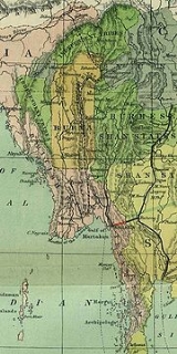
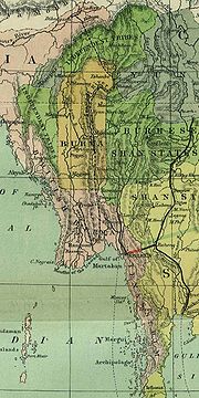
The Irrawaddy Delta or Ayeyarwady Delta lies in the Ayeyarwady Region , the lowest expanse of land in Burma that fans out from the limit of tidal influence at Myan Aung to the Bay of Bengal and Andaman Sea, 290 km to the south at the mouth of the Ayeyarwady River...
(Ayeyarwady, Bago and Yangon Regions), as well as coastal regions of the country (Rakhine
Rakhine State
Rakhine State is a Burmese state. Situated on the western coast, it is bordered by Chin State in the north, Magway Region, Bago Region and Ayeyarwady Region in the east, the Bay of Bengal to the west, and the Chittagong Division of Bangladesh to the northwest. It is located approximately between...
and Mon State
Mon State
Mon State is an administrative division of Myanmar. It is sandwiched between Kayin State on the east, the Andaman Sea on the west, Bago Region on the north and Tanintharyi Region on the south, and has a short border with Thailand's Kanchanaburi Province at its south-eastern tip. The land area is...
s and Tanintharyi Region).
Historically, Lower Burma referred to the part of Burma annexed by the British Empire
British Empire
The British Empire comprised the dominions, colonies, protectorates, mandates and other territories ruled or administered by the United Kingdom. It originated with the overseas colonies and trading posts established by England in the late 16th and early 17th centuries. At its height, it was the...
after the end of the Second Anglo-Burmese War in 1852, plus the former kingdom of Arakan
Rakhine State
Rakhine State is a Burmese state. Situated on the western coast, it is bordered by Chin State in the north, Magway Region, Bago Region and Ayeyarwady Region in the east, the Bay of Bengal to the west, and the Chittagong Division of Bangladesh to the northwest. It is located approximately between...
and the territory of Tenasserim which the British had taken control of in 1826. Lower Burma was centred at Rangoon, and composed of all of the coast of modern Burma, and also the lower basin of the Irrawaddy River
Ayeyarwady River
The Irrawaddy River or Ayeyarwady River is a river that flows from north to south through Burma . It is the country's largest river and most important commercial waterway. Originating from the confluence of the N'mai and Mali rivers, it flows relatively straight North-South before emptying through...
, including Prome. Until the early 1800s, Lower Burma was predominantly populated by the Mon
Mon people
The Mon are an ethnic group from Burma , living mostly in Mon State, Bago Division, the Irrawaddy Delta, and along the southern Thai–Burmese border. One of the earliest peoples to reside in Southeast Asia, the Mon were responsible for the spread of Theravada Buddhism in Burma and Thailand...
and Karen
Karen people
The Karen or Kayin people , are a Sino-Tibetan language speaking ethnic group which resides primarily in southern and southeastern Burma . The Karen make up approximately 7 percent of the total Burmese population of approximately 50 million people...
tribes and was a historical stronghold of the Mon people.