Mount Kerinci
Encyclopedia
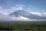
Mount Kerinci is the highest volcano
in Indonesia
, and the highest peak on the island of Sumatra
. It is surrounded by the lush forest of Kerinci Seblat National Park
, home to the endangered species of Sumatran Tiger
and Sumatran Rhinoceros
.
, near the west coast, and is about 130 km (81 mi) south of Padang
. It is the most prominent feature of the terrain of Kerinci Seblat National Park
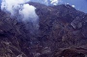
, with pine-forested slopes rising 2,400-3,300 metres above the surrounding basin, and a cone 13 km (8 mi) wide and 25 km (16 mi) long at the base, elongated in the north-south direction. At the summit there is a deep 600 m (1,969 ft) wide crater, often partially filled by a small crater lake
on the northeast side of the crater floor.

s. Kerinci last erupted in 2004, and continues to spew clouds of sulphurous smoke, with plumes reaching as high as 1000 m (3,281 ft) above the summit. While there is farmland in the area, and a tea plantation on its southern slope, Kerinci, being located in an Indonesian national park, and perhaps out of respect for its frequent growlings as well, sits in an area that is sparsely populated by Indonesian population-density standards.
by car or bus. The climb and descent normally takes 3 days and 2 nights, if you choose to go to the summit. You may also choose to go up only till Camp 2 or 2.5, skipping the summit attempt which is a night climb; and take 2 days and 1 night instead.
Kerinci's terrain consists of thick jungle
, it can get muddy and slippery even if there are only mild drizzles, which may occur occasionally even during the dry season. To climb the volcano you need a guide, for there have been rare cases of people disappearing after attempting to trek alone.
at 1,996 meters.
. Today, Kecik Wong Gedang Wok people is so limited due to many of them has assimilated with Proto-Malay tribe which come later. There are around of 135 dialects uses only along the valley makes ethnography
analysis is difficult to conduct.
Volcano
2. Bedrock3. Conduit 4. Base5. Sill6. Dike7. Layers of ash emitted by the volcano8. Flank| 9. Layers of lava emitted by the volcano10. Throat11. Parasitic cone12. Lava flow13. Vent14. Crater15...
in Indonesia
Indonesia
Indonesia , officially the Republic of Indonesia , is a country in Southeast Asia and Oceania. Indonesia is an archipelago comprising approximately 13,000 islands. It has 33 provinces with over 238 million people, and is the world's fourth most populous country. Indonesia is a republic, with an...
, and the highest peak on the island of Sumatra
Sumatra
Sumatra is an island in western Indonesia, westernmost of the Sunda Islands. It is the largest island entirely in Indonesia , and the sixth largest island in the world at 473,481 km2 with a population of 50,365,538...
. It is surrounded by the lush forest of Kerinci Seblat National Park
Kerinci Seblat National Park
Kerinci Seblat National Park is the largest national park in Sumatra Indonesia. It has a total area of 13,791 km2, and spans four provinces: West Sumatra, Jambi, Bengkulu and South Sumatra....
, home to the endangered species of Sumatran Tiger
Sumatran Tiger
The Sumatran tiger is a tiger subspecies that inhabits the Indonesian island of Sumatra and has been classified as critically endangered by IUCN in 2008 as the population is projected at 176 to 271 mature individuals, with no subpopulation having an effective population size larger than 50...
and Sumatran Rhinoceros
Sumatran Rhinoceros
The Sumatran Rhinoceros is a member of the family Rhinocerotidae and one of five extant rhinoceroses. It is the only extant species of the genus Dicerorhinus. It is the smallest rhinoceros, although is still a large mammal. This rhino stands high at the shoulder, with a head-and-body length of ...
.
Geography
Kerinci is located in Province of Jambi, the west central part of the island, in the Barisan MountainsBarisan Mountains
The Bukit Barisan or the Barisan Mountains are a mountain range on the western side of Sumatra, Indonesia, covering nearly 1,700 km from the north to the south of the island. The Bukit Barisan range consists primarily of volcanoes shrouded in dense jungle cover, including Sumatran tropical pine...
, near the west coast, and is about 130 km (81 mi) south of Padang
Padang, Indonesia
Padang is the capital and largest city of West Sumatra, Indonesia. It is located on the western coast of Sumatra at . It has an area of and a population of over 833,000 people at the 2010 Census.-History:...
. It is the most prominent feature of the terrain of Kerinci Seblat National Park
Kerinci Seblat National Park
Kerinci Seblat National Park is the largest national park in Sumatra Indonesia. It has a total area of 13,791 km2, and spans four provinces: West Sumatra, Jambi, Bengkulu and South Sumatra....
, with pine-forested slopes rising 2,400-3,300 metres above the surrounding basin, and a cone 13 km (8 mi) wide and 25 km (16 mi) long at the base, elongated in the north-south direction. At the summit there is a deep 600 m (1,969 ft) wide crater, often partially filled by a small crater lake
Crater lake
A crater lake is a lake that forms in a volcanic crater or caldera, such as a maar; less commonly and with lower association to the term a lake may form in an impact crater caused by a meteorite. Sometimes lakes which form inside calderas are called caldera lakes, but often this distinction is not...
on the northeast side of the crater floor.

Volcanic activity
Kerinci is more active than most Indonesian volcanoes, with nearly annual phreatic eruptionPhreatic eruption
A phreatic eruption, also called a phreatic explosion or ultravulcanian eruption, occurs when rising magma makes contact with ground or surface water. The extreme temperature of the magma causes near-instantaneous evaporation to steam, resulting in an explosion of steam, water, ash, rock, and...
s. Kerinci last erupted in 2004, and continues to spew clouds of sulphurous smoke, with plumes reaching as high as 1000 m (3,281 ft) above the summit. While there is farmland in the area, and a tea plantation on its southern slope, Kerinci, being located in an Indonesian national park, and perhaps out of respect for its frequent growlings as well, sits in an area that is sparsely populated by Indonesian population-density standards.
Climbing
Kerinci can be climbed from the village of Kersik Tuo, 6 or 7 hours away from PadangPadang, Indonesia
Padang is the capital and largest city of West Sumatra, Indonesia. It is located on the western coast of Sumatra at . It has an area of and a population of over 833,000 people at the 2010 Census.-History:...
by car or bus. The climb and descent normally takes 3 days and 2 nights, if you choose to go to the summit. You may also choose to go up only till Camp 2 or 2.5, skipping the summit attempt which is a night climb; and take 2 days and 1 night instead.
Kerinci's terrain consists of thick jungle
Jungle
A Jungle is an area of land in the tropics overgrown with dense vegetation.The word jungle originates from the Sanskrit word jangala which referred to uncultivated land. Although the Sanskrit word refers to "dry land", it has been suggested that an Anglo-Indian interpretation led to its...
, it can get muddy and slippery even if there are only mild drizzles, which may occur occasionally even during the dry season. To climb the volcano you need a guide, for there have been rare cases of people disappearing after attempting to trek alone.
Lakes
The mountain has 15 lakes which the biggest are Kerinci Lake and Gunung Tujuh Lake. The 4,200-hectare of Kerinci Lake lies at a height of 650 meters, is the host of annual July Kerinci Lake Festival. While Gunung Tujuh Lake means Seven Mountains Lake which there are 7 peaks surrounding the lake. It is also the highest lake in Southeast AsiaSoutheast Asia
Southeast Asia, South-East Asia, South East Asia or Southeastern Asia is a subregion of Asia, consisting of the countries that are geographically south of China, east of India, west of New Guinea and north of Australia. The region lies on the intersection of geological plates, with heavy seismic...
at 1,996 meters.
Kecik Wok Gedang Wok
Based on research in 1973, 'Kecik Wok Gedang Wok' people is recognized as the first tribe to settle at a plateau around Mount Kerinci 10,000 years ago. It was older than Indian Inca civilizationInca civilization
The Andean civilizations made up a loose patchwork of different cultures that developed from the highlands of Colombia to the Atacama Desert. The Andean civilizations are mainly based on the cultures of Ancient Peru and some others such as Tiahuanaco. The Inca Empire was the last sovereign...
. Today, Kecik Wong Gedang Wok people is so limited due to many of them has assimilated with Proto-Malay tribe which come later. There are around of 135 dialects uses only along the valley makes ethnography
Ethnography
Ethnography is a qualitative method aimed to learn and understand cultural phenomena which reflect the knowledge and system of meanings guiding the life of a cultural group...
analysis is difficult to conduct.
See also
- List of volcanoes in Indonesia
- Kerinci Seblat National ParkKerinci Seblat National ParkKerinci Seblat National Park is the largest national park in Sumatra Indonesia. It has a total area of 13,791 km2, and spans four provinces: West Sumatra, Jambi, Bengkulu and South Sumatra....

