
Mount Keira
Encyclopedia
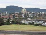
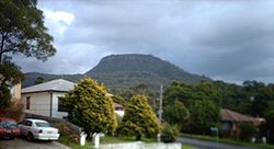
Mount Keira is a 464 metre high mountain
lying 4 kilometres northwest of the city of Wollongong
, New South Wales
, Australia
. Its distinctive shape and proximity to Wollongong make it a major local landmark. It is noted for the views of the city from the popular summit lookout and its history of coal mining
. It was formed as part of the Illawarra
escarpment fold between 80 and 60 million years ago and the erosion by creeks that ensued.
Mount Keira is also the name of the suburb that includes the mountain's summit and southern flank.
Keira is an indigenous Australian
term meaning large lagoon
or high mountain
. The aborigines called it Djera, meaning wild turkey. The first maps of the area called it Keera, later adding the i.
which it joins by a high saddle
on the back (western) side. It is capped by a westward sloping plateau
of relatively hard sandstone
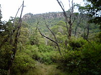
ringed on the remaining 3 sides by cliffs. From the cliff base the mountain slopes down to the surrounding foothills and coastal plain. From Wollongong the mountain looks rather flat topped; while from the north it appears part of the escarpment.
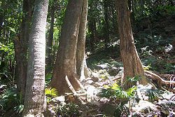
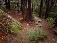
The majority of the mountain is forested with eucalypt
(sclerophyll
) forest and sub-tropical rainforest
, while civilization encroaches on the lower slopes. Surrounding suburbs are (from north to south): Balgownie
, Mount Pleasant
; Mount Ousley
; Keiraville; West Wollongong
; Figtree
and Mount Kembla
.
 The mountain is drained by several creeks, and has many gullies on its slopes such as the ones present on the ring track and the one directly south of the mountain known as Hell Hole after an axe murder by a convict who dispatched a labourer known as Old Tom in Byarong Creek. The south and western slopes are drained by Byarong Creek which flows west of Byarong Park before descending to Figtree
and then to the sea. The eastern slopes are drained by creeks that flow into Para or Fairy Creek which flows through the Wollongong Botanic Gardens
before arriving at Fairy Lagoon at Puckeys Estate Reserve
. The northern slopes are drained by Cabbage Tree Creek.
Mount Ousley Road climbs up the northern spur and over the escarpment and is the major road link between Wollongong and Sydney
. On the road is the small suburb of Mount Pleasant
. At Mount Pleasant is the Illawarra Rhododendron Park, located on Parrish Avenue near the start of the Mount Pleasant Track. It contains thousands of azalea
s and hundreds of rhododendron
s as well as camellia
s. A section of rainforest is located in the top section with short walking trails. The park covers 13 hectares.
On the southern side, Mount Keira Road leaves suburbia and winds its way through the bush up the back of the mountain, giving access to the (now closed) Kemira coal mine, Byarong park, Girl Guides camp, Scout
camp, and ultimately the summit lookout via Queen Elizabeth Drive. The Scout camp was established in 1939 by Sid Hoskins and later described by Lady Baden Powell
(wife of Lord Baden Powell
, the founder of Scouting) as "surely one of the most beautiful campsites in the world". Mount Keira Road was built using convict labour in 1835-1836, surveyed by Surveyor General Thomas Mitchell, using much of the route used by O'Briens Road but descending the south and west slopes of Mount Keira rather than Mount Nebo, a nearby hill to Mount Keira's south. Byarong Park was originally a pit pony grazing area, the ponies were stabled at the site of the Girl Guide camp.
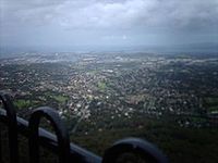
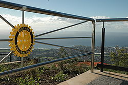 In 1955 the Rotary Club of Wollongong, with the active support of local government and businesses, constructed the summit lookout. In 2005, the Summit Park refurbishment provided an opening up of magnificent vistas of the coastal plain from Kiama to Sydney, and is managed as an annex of the Wollongong Botanic Garden. It contains 9.4 hectares of land and it is a major tourist destination, many visitors to Wollongong climbing the Ken Ausburn Track.
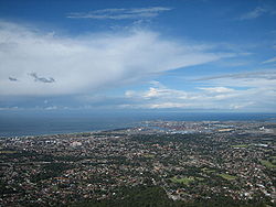
 As well as overlooking Wollongong, the summit provides views from the Kurnell
Oil Refinery 53 kilometres north to the northern headland of Jervis Bay
, 64 kilometres south, as well as the Blue Mountains to the far west and out to sea to the east for 77 kilometres. On a good day it is easy to see the northern escarpment and, from the Victoria Rock Lookout, reached by a short trail or cliff track, one can see Knights Hill, Mount Kembla
and Saddleback Mountain
clearly. Summit facilities include car parking spaces, toilets, picnic areas with wooden tables and benches and a kiosk
/restaurant, the Mountaintop. An early man to climb the mountain of note was botanist Allan Cunningham
.
At the summit is the Mountaintop Restaurant, used for food, drink and function purposes. Just west of it by a few metres is the transmission tower, visible easily from the plain and a local landmark. The new larger tower was built by Telstra with the ownership reverting back to Wollongong City Council on completion. There was a campaign to paint it green so it would blend with the summit plateau canopy but this failed and it remains grey.
In 2006 binocular telescope
s were fitted, and after several tests, vandalism and malfunctioning being a problem, they are currently in use for gold coin donation to the rotary club. With these it is possible to see up close places like Stanwell Park
in the distance and Brokers Nose trigonometry
station.
The summit lookout and Queen Elizabeth Drive was officially opened in 1959, but attempts to secure land from the Australian Iron and Steel company began in 1954. Both a map and plaque remain from the original lookout park design, though the previous hang-gliding ramp has been taken down for the new observation walkways.
The mountain has been heavily logged
in the past, yielding blackbutt, blue gum, turpentine and other timbers. Red cedar in particular was highly prized, and there are stories of giant trees with trunk diameters of 3 metres or more being felled. Remnant bushland on the west and north slopes and a few trees defying extensive logging still exist, but much of the east slopes are replaced bushland grown after clearing since the 1930s.
Plant species found on the mountain include:
Introduced weed
s such as lantana (Lantana camara
) have also gained a hold on the mountain, particularly since the 1968 bushfires.
The forests provides habitat for a large number of bird and other fauna species.
Notable fauna species include:
There is also a population of introduced Rusa deer
residing on and around the mountain, which are often seen by local residents at dusk or dawn.
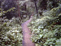
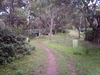
 The Mount Keira Ring Track provides walkers with a moderate 5.5 kilometre (3–5 hour) round trip. The Ring Track encircles the mountain at an average height of 250 metres. The walk can be commenced from a number of locations, including Mount Keira summit, Byarong Park, the Scout Camp and Queen Elizabeth Drive. The Ring Track can also be joined from the Mount Pleasant Track, which starts from Parrish Avenue. From Byarong Park, a picnic area with parking and an information bay, access to the Ring Track is via a short link track that runs from the northern perimeter of the picnic area to the entrance of the Girl Guide Camp road. The link track crosses the Guide Camp road and then ascends a short distance through rainforest, before joining the Ring Track. From the junction, two branches of the Ring Track ascend the mountain. The left branch gently climbs the southern flank of Mount Keira, following Mitchells Road to a saddle located at the junction of Mount Keira Road and Queen Elizabeth Drive. The right branch traverses the mountain's eastern flank, before emerging at Geordies Flat on Mount Keira Road. From Geordies Flat, the northern branch of the Ring Track climbs steadily to the junction of Mount Keira Road and Queen Elizabeth Drive. At this point, walkers can also join the Robertsons Lookout track, a short (1.2km) walk that terminates at a spectacular view that takes in the Scout Camp, Mount Keira and the Illawarra coast. At Geordies Flat, a vehicle width trail leads north to Parrish avenue. Walkers combine this trail with the Ring Track and the Mount Pleasant walking track to complete a loop walk.
Highlights of the Ring Track are rainforest and many species of unique Australian animals, including wallabies, lyrebirds, brush turkeys, echidnas. Lyrebirds are common on the southern slopes. Rain forests have a mostly open understorey, consisting of ferns and low shrubs. Weeds such as Lantana
are evident where the natural environment has been disturbed. Eucalyptus forests thrive where the rain forests have been cleared but even here rainforest plants typically dominate the understorey.
Walkers can climb from the Ring Track's southern branch to Mount Keira summit via the Dave Walsh Track, which joins the Ring Track opposite the Scout Camp Road, or from the northern branch via a branch track that emerges about half-way along Queen Elizabeth Drive. At the summit, the Dave Walsh track emerges at Five Islands Lookout. A short (200 metre) track leads to the summit park, where there is parking, toilets and a cafe. With care, walkers using the short northern link to Queen Elizabeth Drive can turn left when they reach the road and walk along the road to the summit. Walkers need to exercise great caution when walking along Queen Elizabeth Road because the road is narrow and steep with blind corners that limit visibility of both cars and walkers. From Mount Keira summit, fine views of Warra to the south and Brokers Nose Promontory to the north can be seen.
The track surface is variable. On the southern and eastern flanks, the track is reasonably well formed and the gradients are relatively steady. The northern branch is steeper and more rugged. The northern flank contains some particularly magnificent rain forests. The southern section of the track follows an early convict built road on Mount Keira, some of which is still visible. A similar feature, an early attempt to construct a carriageway, is visible west of the summit track on Mount Kembla
. Also on the southern flank there is also an old telegraph camp site.
The Ring Track is a locally well known and is popular with joggers, walkers and school groups. The track was rebuilt after it was damaged in 1998 by severe storms.
 The Dave Walsh Track, named after a scout leader, climbs from Mount Keira Road opposite the scout Camp road through a small open area of ground ferns, up the western slope of Mount Keira, to Five Islands Lookout and the Summit Track. At the Mount Keira summit, it can also be reached via a maintenance trail that leads from the carpark in Summit Park. The tree growth is mainly [Eucalyptus], ground plants including [Lomandra Longifolia] and [Maidenhair fern]. Wallabies, lizards, snakes and many forms of bird and insects live in the area.
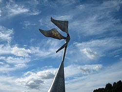
 The Ken Ausburn Track begins at the end of Northfields Avenue (near the University of Wollongong
and Wollongong Botanic Garden). It climbs up a steep grass path and turns into a section of wooden steps and a boardwalk. At the top of the steps is a plaque indicating several bird species to be found on the track. Near this is an oddly out of place lemon
tree. It follows a level path to an open grass area where it then reaches the Lawrence Hargrave
Memorial Sculpture, situated in an open grass area. The sculpture was made from 1988 to 1989 by Herbert "Bert" Flugelman, and is of stainless steel and part of the University of Wollongong Art Collection.
After this the track goes along gradually climbing a ridge until it reaches the Northern Illawarra Lookout, which gives views to the north and has a plaque telling of the shipwreck at Towradgi Point. From here it continues through a cutting, with a plaque indicating the cutting is a survivor from the Mount Keira Tramway opened in 1859. The track goes up some more wooden steps and reaches a brick airshaft completed in 1907 used to ventilate the Kemira Colliery, and a plaque tells of the mines history. From here the track goes for a short distance before reaching the Mount Pleasant Management Trail, and then to the northeastern entrance to the Ring Track, at Geordies Flat on Mount Keira Road. The track is popular with joggers and tourists, and has many plaques indicating various sights such as a remaining grey ironbark left from extensive logging in the late 19th century and several plants such as the invasive weed Lantana
Camara and the native Settlers Flax.
The Mount Pleasant Track is 750 metres long. It extends between Parrish Avenue at Mount Pleasant and Mount Keira Road. By car, Parrish Avenue is reached by turning left off Mount Ousley Road (immediately before the Mount Pleasant road overpass bridge, driving southbound), and then right onto the overpass bridge. The track climbs the middle slopes of Mount Keira via dense rainforest. From Parrish Avenue, the walk steeply ascends a 3 metre wide trail for about 300 metres before narrowing to less than a metre. The final 500 metres wind through the rainforest, which contains many ferns, vines and palms. Large boulders are evidence of previous rockfalls from the sandstone plateau, which forms the escarpment cliffs and Mount Keira summit. Over the last 350 metres the gradient decreases until it reaches the Ring Track. About 100 metres north of the track-head at Parrish avenue are the Illawarra Rhododendron Gardens. The Gardens are lush, quiet and pleasantly cool in most seasons. Walkers can complete a loop back to Parrish Avenue by turning left onto the Ring Track and left again onto the Mount Pleasant Management Trail at Geordies Flat.
The Mount Pleasant Management Trail is a trail used for walking and mountain bike riding, bicycles being permitted only on management trails and not on walking tracks in the Illawarra Escarpment State Conservation Area. The trail travels between the suburb of Mount Pleasant and Mount Keira Road, where it emerges at the hairpin bend (Geordies Flat). The trail is 2 to 3 metres wide. From Mount Pleasant the trail ascends steadily to its junction with the Ken Ausburn Track, which is located on the walker's left (east side of the trail). From here ascends a steep hill before levelling out to Mount Keira Road. Near the entrance to the Ken Ausburn track, views of Wollongong can be had. From Mount Pleasant good views of the northern cliff face can be seen. Birdwatching is an activity on this track, for many species can easily be seen including lyrebird
s.
The Keira Summit Track skirts the edge of the Mount Keira cliffline. It links the Queen Victoria Lookout and Five Islands Lookout. The track forms a short (600 metre) loop when combined with a management trail that leads between the Five Islands lookout and the summit car park. The track goes through thick bush at the eastern clifftop and includes Sleber's Mint Bush, Lomandra grasses and many native flowering plants.
, a qualified geologist.
In 1848 James Shoobert, a retired sea captain, drove a tunnel into what is now known as the No. 3 (Wongawilli) seam. He then observed an outcrop of the No. 2 (Balgownie or 4-ft) seam, in which the coal was of better quality, and drove tunnels into it in 1849 and 1850. This was known as the Albert Coal Mine and was the first in the Illawarra.
Shoobert lacked the capital to develop the mine and in 1856 sold it by auction to Henry Osborne
.
In April 1857 a new tunnel was opened into the higher No 1 (Bulli) seam a short distance away by William Robson for Osborne and called the Osborne Wallsend Colliery.
On 16 April 1857 the first 3.5 tons of coal from the new mine was delivered to the wharf at Wollongong’s Belmore Basin by bullock team for trial in the S.S. Illawarra. Keira coal gained a reputation for being superior to any other coal, and by the 1870s large shipments were being made to Sydney, India and parts of Asia
Coal was originally forked into approximately 1 ton capacity wooden skips, hauled to the surface by horse and then carted down the mountain by a track joining Mount Keira Road near Hurt Street. Later improvements include a Main and Tail Rope Haulage installation to bring coal to the surface, and a self acting skip incline (that is, empty skips hauled up to the mine by the descending loaded skips) to transport the coal to the foot of the mountain at what is now Gooyong Street Keiraville
In May 1861 a narrow gauge tramway was constructed from the incline to Belmore Basin (Wollongong Harbour) after the Mount Keira Tramways Act was passed by parliament. In 1878 the tramroad was widened to standard gauge and horse teams used for hauling the coal were replaced by steam locomotives. These locomotives, the Keira No. 1 and Keira No. 2 were the first locomotives to work on this coal route but steam locomotives were earlier used at Bulli Colliery from 1867 - even though the first Bulli locomotive purchased proved too heavy for the track which had previously been designed for an ingenious gravitational coal-skip incline to the jetty over four cutting and four bridges. The locomotives at Keira ceased running in 1954 when the line was closed.
On a modern street map the route of the tramway followed Gooyong Street, Rose Street, Throsby Drive (Tramway Bridge) and then between Campbell Street and Smith Street (including the Illawarra Master Builders Club carpark) to Osborne Park and Belmore Basin. The route can still be traced on a modern aerial or satellite photograph.
In 1937 Australian Iron and Steel (later a subsidiary of BHP and then BHP Billiton
) acquired the colliery for its Port Kembla steelworks.
In 1942 a diesel locomotive was introduced at the mine, the first underground diesel locomotive in Australia.
In 1954 the skipway and tramway was replaced by a tunnel driven from the escarpment at the head of the company’s private railway between Mount Nebo
and Mount Kembla
. In 1955 the mine was renamed Kemira (from Kembla and Keira).
Longwall mining
was introduced in the 1960s.
Peak production was reached in the year ending November 1979 with 770,684 tonnes.
In 1982 a downturn in the steel industry resulted in 189 employees (60% of the workforce) being retrenched, resulting in a 16 day “sit-in” protest by 30, and mining finally ceased on 27 September 1991.
Geera, who was now the only child left on their escarpment home, had no one to play with and no one to talk to as her father was often away. Geera spent all day sitting, hunched over and watching the camps of the local Aboriginals and looking out to sea to her five sisters. Eventually she turned to stone, dust and leaves building up around her until she became a part of the escarpment. She is known today as Mount Keira.
Mountain
Image:Himalaya_annotated.jpg|thumb|right|The Himalayan mountain range with Mount Everestrect 58 14 160 49 Chomo Lonzorect 200 28 335 52 Makalurect 378 24 566 45 Mount Everestrect 188 581 920 656 Tibetan Plateaurect 250 406 340 427 Rong River...
lying 4 kilometres northwest of the city of Wollongong
Wollongong, New South Wales
Wollongong is a seaside city located in the Illawarra region of New South Wales, Australia. It lies on the narrow coastal strip between the Illawarra Escarpment and the Pacific Ocean, 82 kilometres south of Sydney...
, New South Wales
New South Wales
New South Wales is a state of :Australia, located in the east of the country. It is bordered by Queensland, Victoria and South Australia to the north, south and west respectively. To the east, the state is bordered by the Tasman Sea, which forms part of the Pacific Ocean. New South Wales...
, Australia
Australia
Australia , officially the Commonwealth of Australia, is a country in the Southern Hemisphere comprising the mainland of the Australian continent, the island of Tasmania, and numerous smaller islands in the Indian and Pacific Oceans. It is the world's sixth-largest country by total area...
. Its distinctive shape and proximity to Wollongong make it a major local landmark. It is noted for the views of the city from the popular summit lookout and its history of coal mining
Coal mining
The goal of coal mining is to obtain coal from the ground. Coal is valued for its energy content, and since the 1880s has been widely used to generate electricity. Steel and cement industries use coal as a fuel for extraction of iron from iron ore and for cement production. In the United States,...
. It was formed as part of the Illawarra
Illawarra
Illawarra is a region in the Australian state of New South Wales. It is a coastal region situated immediately south of Sydney and north of the Shoalhaven or South Coast region. It encompasses the cities of Wollongong, Shellharbour, Shoalhaven and the town of Kiama. The central region contains Lake...
escarpment fold between 80 and 60 million years ago and the erosion by creeks that ensued.
Mount Keira is also the name of the suburb that includes the mountain's summit and southern flank.
Keira is an indigenous Australian
Indigenous Australians
Indigenous Australians are the original inhabitants of the Australian continent and nearby islands. The Aboriginal Indigenous Australians migrated from the Indian continent around 75,000 to 100,000 years ago....
term meaning large lagoon
Lagoon
A lagoon is a body of shallow sea water or brackish water separated from the sea by some form of barrier. The EU's habitat directive defines lagoons as "expanses of shallow coastal salt water, of varying salinity or water volume, wholly or partially separated from the sea by sand banks or shingle,...
or high mountain
Mountain
Image:Himalaya_annotated.jpg|thumb|right|The Himalayan mountain range with Mount Everestrect 58 14 160 49 Chomo Lonzorect 200 28 335 52 Makalurect 378 24 566 45 Mount Everestrect 188 581 920 656 Tibetan Plateaurect 250 406 340 427 Rong River...
. The aborigines called it Djera, meaning wild turkey. The first maps of the area called it Keera, later adding the i.
Description
Mount Keira forms part of the Illawarra escarpmentIllawarra escarpment
The Illawarra Escarpment is the fold created cliffs and plateau eroded outcrop mountain range west of the Illawarra coastal plain south of Sydney, Australia, enclosing the region known as the Illawarra which stretches from Stanwell Park in the north to Kiama, Gerringong and the Shoalhaven river in...
which it joins by a high saddle
Mountain pass
A mountain pass is a route through a mountain range or over a ridge. If following the lowest possible route, a pass is locally the highest point on that route...
on the back (western) side. It is capped by a westward sloping plateau
Plateau
In geology and earth science, a plateau , also called a high plain or tableland, is an area of highland, usually consisting of relatively flat terrain. A highly eroded plateau is called a dissected plateau...
of relatively hard sandstone
Sandstone
Sandstone is a sedimentary rock composed mainly of sand-sized minerals or rock grains.Most sandstone is composed of quartz and/or feldspar because these are the most common minerals in the Earth's crust. Like sand, sandstone may be any colour, but the most common colours are tan, brown, yellow,...
ringed on the remaining 3 sides by cliffs. From the cliff base the mountain slopes down to the surrounding foothills and coastal plain. From Wollongong the mountain looks rather flat topped; while from the north it appears part of the escarpment.
The majority of the mountain is forested with eucalypt
Eucalypt
Eucalypts are woody plants belonging to three closely related genera:Eucalyptus, Corymbia and Angophora.In 1995 new evidence, largely genetic, indicated that some prominent Eucalyptus species were actually more closely related to Angophora than to the other eucalypts; they were split off into the...
(sclerophyll
Sclerophyll
Sclerophyll is the term for a type of vegetation that has hard leaves and short internodes . The word comes from the Greek sclero and phyllon ....
) forest and sub-tropical rainforest
Rainforest
Rainforests are forests characterized by high rainfall, with definitions based on a minimum normal annual rainfall of 1750-2000 mm...
, while civilization encroaches on the lower slopes. Surrounding suburbs are (from north to south): Balgownie
Balgownie, New South Wales
Balgownie is a small suburb of Wollongong City, New South Wales, Australia.Balgownie lies to the north-west of the Wollongong CBD. It stretches from the lower slopes of Mount Keira along the Illawarra escarpment to the base of the Broker's Nose promontory...
, Mount Pleasant
Mount Pleasant, New South Wales
Mount Pleasant is a suburb in the city of Wollongong, New South Wales, Australia. It is situated on the northern flank of Mount Keira extending across to the Illawarra escarpment. It is home to the Rhododendron Park, found on Parrish Avenue.-History:...
; Mount Ousley
Mount Ousley, New South Wales
Mount Ousley is a residential suburb situated on the foothills of Mount Keira about four kilometres northwest from the city of Wollongong, New South Wales, Australia. It is also the name of the road which crosses the nearby Illawarra Escarpment and is adjacent to the University of Wollongong. Mount...
; Keiraville; West Wollongong
West Wollongong, New South Wales
West Wollongong is the innermost western suburb of the coastal city of Wollongong, New South Wales, Australia. It is mainly a residential area, serviced by a small commercial strip with a music store, chicken shop, electric goods store and carpet store along the Princes Highway with several petrol...
; Figtree
Figtree, New South Wales
Figtree is an inner western suburb of Wollongong, New South Wales, Australia. It is southwest of West Wollongong and connected to Wollongong by the Princes Highway and The Avenue....
and Mount Kembla
Mount Kembla
Mount Kembla is a mountain in New South Wales, Australia, as well a semi-rural township of Wollongong, which gets its name from the mountain.Kembla is an Aboriginal word meaning "plenty of game"....
.
Figtree, New South Wales
Figtree is an inner western suburb of Wollongong, New South Wales, Australia. It is southwest of West Wollongong and connected to Wollongong by the Princes Highway and The Avenue....
and then to the sea. The eastern slopes are drained by creeks that flow into Para or Fairy Creek which flows through the Wollongong Botanic Gardens
Wollongong Botanic Gardens
The Wollongong Botanic Garden is located in the Wollongong suburb of Keiraville at the foot of Mount Keira in New South Wales, Australia. It is the local botanical gardens of the Illawarra and was opened in September 1970...
before arriving at Fairy Lagoon at Puckeys Estate Reserve
Puckeys Estate Reserve
Puckey's Estate Reserve is a coastal nature reserve in Wollongong, Australia. It is mainly she-oak forest, but also has sand dune and wetland areas, including areas along Para Creek...
. The northern slopes are drained by Cabbage Tree Creek.
Mount Ousley Road climbs up the northern spur and over the escarpment and is the major road link between Wollongong and Sydney
Sydney
Sydney is the most populous city in Australia and the state capital of New South Wales. Sydney is located on Australia's south-east coast of the Tasman Sea. As of June 2010, the greater metropolitan area had an approximate population of 4.6 million people...
. On the road is the small suburb of Mount Pleasant
Mount Pleasant, New South Wales
Mount Pleasant is a suburb in the city of Wollongong, New South Wales, Australia. It is situated on the northern flank of Mount Keira extending across to the Illawarra escarpment. It is home to the Rhododendron Park, found on Parrish Avenue.-History:...
. At Mount Pleasant is the Illawarra Rhododendron Park, located on Parrish Avenue near the start of the Mount Pleasant Track. It contains thousands of azalea
Azalea
Azaleas are flowering shrubs comprising two of the eight subgenera of the genus Rhododendron, Pentanthera and Tsutsuji . Azaleas bloom in spring, their flowers often lasting several weeks...
s and hundreds of rhododendron
Rhododendron
Rhododendron is a genus of over 1 000 species of woody plants in the heath family, most with showy flowers...
s as well as camellia
Camellia
Camellia, the camellias, is a genus of flowering plants in the family Theaceae. They are found in eastern and southern Asia, from the Himalaya east to Korea and Indonesia. There are 100–250 described species, with some controversy over the exact number...
s. A section of rainforest is located in the top section with short walking trails. The park covers 13 hectares.
On the southern side, Mount Keira Road leaves suburbia and winds its way through the bush up the back of the mountain, giving access to the (now closed) Kemira coal mine, Byarong park, Girl Guides camp, Scout
Scouting
Scouting, also known as the Scout Movement, is a worldwide youth movement with the stated aim of supporting young people in their physical, mental and spiritual development, that they may play constructive roles in society....
camp, and ultimately the summit lookout via Queen Elizabeth Drive. The Scout camp was established in 1939 by Sid Hoskins and later described by Lady Baden Powell
Olave Baden-Powell
Olave St Clair Baden-Powell, Baroness Baden-Powell, GBE was born Olave St Clair Soames in Chesterfield, England...
(wife of Lord Baden Powell
Robert Baden-Powell, 1st Baron Baden-Powell
Robert Stephenson Smyth Baden-Powell, 1st Baron Baden-Powell, Bt, OM, GCMG, GCVO, KCB , also known as B-P or Lord Baden-Powell, was a lieutenant-general in the British Army, writer, and founder of the Scout Movement....
, the founder of Scouting) as "surely one of the most beautiful campsites in the world". Mount Keira Road was built using convict labour in 1835-1836, surveyed by Surveyor General Thomas Mitchell, using much of the route used by O'Briens Road but descending the south and west slopes of Mount Keira rather than Mount Nebo, a nearby hill to Mount Keira's south. Byarong Park was originally a pit pony grazing area, the ponies were stabled at the site of the Girl Guide camp.
Kurnell, New South Wales
Kurnell is a suburb in southern Sydney, in the state of New South Wales, Australia. Kurnell is located south of the Sydney central business district, in the local government area of the Sutherland Shire....
Oil Refinery 53 kilometres north to the northern headland of Jervis Bay
Jervis Bay Territory
The Jervis Bay Territory is a territory of the Commonwealth of Australia. It was surrendered by the state of New South Wales to the Commonwealth Government in 1915 so that the Federal capital at Canberra would have "access to the sea"....
, 64 kilometres south, as well as the Blue Mountains to the far west and out to sea to the east for 77 kilometres. On a good day it is easy to see the northern escarpment and, from the Victoria Rock Lookout, reached by a short trail or cliff track, one can see Knights Hill, Mount Kembla
Mount Kembla
Mount Kembla is a mountain in New South Wales, Australia, as well a semi-rural township of Wollongong, which gets its name from the mountain.Kembla is an Aboriginal word meaning "plenty of game"....
and Saddleback Mountain
Saddleback Mountain (New South Wales)
Saddleback Mountain is a mountain in New South Wales, Australia which rises to about 600 metres above sea level and has spectacular views of Noorinan Mountain, 662 metres above sea level, and Barren Grounds Plateau to the west and south to Coolangatta Mountain and Pigeon House Mountain to...
clearly. Summit facilities include car parking spaces, toilets, picnic areas with wooden tables and benches and a kiosk
Kiosk
Kiosk is a small, separated garden pavilion open on some or all sides. Kiosks were common in Persia, India, Pakistan, and in the Ottoman Empire from the 13th century onward...
/restaurant, the Mountaintop. An early man to climb the mountain of note was botanist Allan Cunningham
Allan Cunningham (botanist)
Allan Cunningham was an English botanist and explorer, primarily known for his travels in New South Wales to collect plants.- Early life :...
.
At the summit is the Mountaintop Restaurant, used for food, drink and function purposes. Just west of it by a few metres is the transmission tower, visible easily from the plain and a local landmark. The new larger tower was built by Telstra with the ownership reverting back to Wollongong City Council on completion. There was a campaign to paint it green so it would blend with the summit plateau canopy but this failed and it remains grey.
In 2006 binocular telescope
Telescope
A telescope is an instrument that aids in the observation of remote objects by collecting electromagnetic radiation . The first known practical telescopes were invented in the Netherlands at the beginning of the 1600s , using glass lenses...
s were fitted, and after several tests, vandalism and malfunctioning being a problem, they are currently in use for gold coin donation to the rotary club. With these it is possible to see up close places like Stanwell Park
Stanwell Park, New South Wales
Stanwell Park is a picturesque coastal village and northern suburb of Wollongong, New South Wales, Australia. It is the northernmost point of the Illawarra coastal strip and lies south of Sydney's Royal National Park. It is situated in a small valley between Bald Hill to the north, Stanwell Tops...
in the distance and Brokers Nose trigonometry
Trigonometry
Trigonometry is a branch of mathematics that studies triangles and the relationships between their sides and the angles between these sides. Trigonometry defines the trigonometric functions, which describe those relationships and have applicability to cyclical phenomena, such as waves...
station.
The summit lookout and Queen Elizabeth Drive was officially opened in 1959, but attempts to secure land from the Australian Iron and Steel company began in 1954. Both a map and plaque remain from the original lookout park design, though the previous hang-gliding ramp has been taken down for the new observation walkways.
Flora and fauna
Eucalypt forest and rainforest cover the mountain summit and undeveloped slopes. Rainforest is predominant in sheltered areas, particularly on the southern side.The mountain has been heavily logged
Logging
Logging is the cutting, skidding, on-site processing, and loading of trees or logs onto trucks.In forestry, the term logging is sometimes used in a narrow sense concerning the logistics of moving wood from the stump to somewhere outside the forest, usually a sawmill or a lumber yard...
in the past, yielding blackbutt, blue gum, turpentine and other timbers. Red cedar in particular was highly prized, and there are stories of giant trees with trunk diameters of 3 metres or more being felled. Remnant bushland on the west and north slopes and a few trees defying extensive logging still exist, but much of the east slopes are replaced bushland grown after clearing since the 1930s.
Plant species found on the mountain include:
- Cabbage tree palm (Livistona australisLivistona australisThe Cabbage-tree Palm is in the Arecaceae family. It is a tall, slender palm growing up to about 25 m in height and 0.35 m diameter. It is crowned with dark, glossy green leaves on petioles 2 m long. It has leaves plaited like a fan; the cabbage of these is small but sweet...
). - Coast white box (Eucalyptus quadrangulataEucalyptus quadrangulataEucalyptus quadrangulata, known as the White-topped Box, is a tree native to eastern Australia.It ranges north from Bundanoon, New South Wales north along the Great Dividing Range in discontinuous patches to Queensland. Locally frequent on the eastern fall of the ranges, at high altitude in wet...
). - Giant stinging tree (Dendrocnide excelsa)
- Native Tamarind (Diploglottis australis).
- Red cedar (Toona australis).
- Sassafras (Doryphora sassafrasDoryphora sassafrasDoryphora sassafras, commonly known as Sassafras, Yellow-, Canary- or Golden sassafras, or Golden Deal, is a species of evergreen tree of the family Atherospermataceae native to the subtropical and temperate rainforests of eastern New South Wales and Queensland, Australia...
). - Turpentine (Syncarpia glomuliferaSyncarpia glomuliferaSyncarpia glomulifera is a tree native to New South Wales and Queensland in Australia, which can grow to more than 30 metres in height...
). - Citronella (Citronella mooreiCitronella mooreiCitronella moorei is a rainforest tree growing in eastern Australia. Common names for this species include Churnwood, Citronella, Soapy Box, Silky Beech, and Corduroy.- Description :...
). - Jackwood (Cryptocarya glaucescensCryptocarya glaucescensCryptocarya glaucescens, known as the Jackwood is a rainforest tree growing in eastern Australia.-Taxonomy:Cryptocarya glaucescens was one of the many species first described by Scottish botanist Robert Brown in his 1810 work Prodromus Florae Novae Hollandiae...
). - Bollygum (Litsea reticulataLitsea reticulataLitsea reticulata is a common Australian tree, growing from near Milton, New South Wales to the Bunya Mountains, Queensland. Common names include Bollygum, Bolly Wood and Brown Beech...
).
Introduced weed
Weed
A weed in a general sense is a plant that is considered by the user of the term to be a nuisance, and normally applied to unwanted plants in human-controlled settings, especially farm fields and gardens, but also lawns, parks, woods, and other areas. More specifically, the term is often used to...
s such as lantana (Lantana camara
Lantana camara
Lantana camara, also known as Spanish Flag or West Indian Lantana, is a species of flowering plant in the verbena family, Verbenaceae, that is native to the American tropics. It has been introduced into other parts of the world as an ornamental plant and is considered an invasive species in many...
) have also gained a hold on the mountain, particularly since the 1968 bushfires.
The forests provides habitat for a large number of bird and other fauna species.
Notable fauna species include:
- EchidnaEchidnaEchidnas , also known as spiny anteaters, belong to the family Tachyglossidae in the monotreme order of egg-laying mammals. There are four extant species, which, together with the platypus, are the only surviving members of that order and are the only extant mammals that lay eggs...
(Tachyglossus aculeatus). - EasternEastern blue-tongued lizardThe Eastern Blue-tongued Lizard is a subspecies of large skink which is common throughout Eastern Australia, often found in bushland and suburban areas where conditions are suitable...
Blue-tongued lizardBlue-tongued lizardBlue tongue lizard redirects here. For the aboriginal Australian myth, see Bluetongue Lizard .Blue-tongued skinks comprise the Australasian genus, Tiliqua, which contains some of the largest members of the skink family . They are commonly called blue-tongued lizards or simply blue-tongues in...
(Tiliqua scincoides scincoides). - Superb lyrebirdLyrebirdA Lyrebird is either of two species of ground-dwelling Australian birds, that form the genus, Menura, and the family Menuridae. They are most notable for their superb ability to mimic natural and artificial sounds from their environment. Lyrebirds have unique plumes of neutral coloured...
(Menura novaehollandiae). - WallabyWallabyA wallaby is any of about thirty species of macropod . It is an informal designation generally used for any macropod that is smaller than a kangaroo or wallaroo that has not been given some other name.-Overview:...
.
There is also a population of introduced Rusa deer
Rusa Deer
The Javan Rusa or Sunda Sambar is a deer native to the islands of Java, Bali and Timor in Indonesia...
residing on and around the mountain, which are often seen by local residents at dusk or dawn.
Walking tracks
Highlights of the Ring Track are rainforest and many species of unique Australian animals, including wallabies, lyrebirds, brush turkeys, echidnas. Lyrebirds are common on the southern slopes. Rain forests have a mostly open understorey, consisting of ferns and low shrubs. Weeds such as Lantana
Lantana
Lantana is a genus of about 150 species of perennial flowering plants in the verbena family, Verbenaceae. They are native to tropical regions of the Americas and Africa but exist as an introduced species in numerous areas, especially in the Australian-Pacific region. The genus includes both...
are evident where the natural environment has been disturbed. Eucalyptus forests thrive where the rain forests have been cleared but even here rainforest plants typically dominate the understorey.
Walkers can climb from the Ring Track's southern branch to Mount Keira summit via the Dave Walsh Track, which joins the Ring Track opposite the Scout Camp Road, or from the northern branch via a branch track that emerges about half-way along Queen Elizabeth Drive. At the summit, the Dave Walsh track emerges at Five Islands Lookout. A short (200 metre) track leads to the summit park, where there is parking, toilets and a cafe. With care, walkers using the short northern link to Queen Elizabeth Drive can turn left when they reach the road and walk along the road to the summit. Walkers need to exercise great caution when walking along Queen Elizabeth Road because the road is narrow and steep with blind corners that limit visibility of both cars and walkers. From Mount Keira summit, fine views of Warra to the south and Brokers Nose Promontory to the north can be seen.
The track surface is variable. On the southern and eastern flanks, the track is reasonably well formed and the gradients are relatively steady. The northern branch is steeper and more rugged. The northern flank contains some particularly magnificent rain forests. The southern section of the track follows an early convict built road on Mount Keira, some of which is still visible. A similar feature, an early attempt to construct a carriageway, is visible west of the summit track on Mount Kembla
Mount Kembla
Mount Kembla is a mountain in New South Wales, Australia, as well a semi-rural township of Wollongong, which gets its name from the mountain.Kembla is an Aboriginal word meaning "plenty of game"....
. Also on the southern flank there is also an old telegraph camp site.
The Ring Track is a locally well known and is popular with joggers, walkers and school groups. The track was rebuilt after it was damaged in 1998 by severe storms.
University of Wollongong
The University of Wollongong is a public university located in the coastal city of Wollongong, New South Wales, Australia, approximately 80 kilometres south of Sydney...
and Wollongong Botanic Garden). It climbs up a steep grass path and turns into a section of wooden steps and a boardwalk. At the top of the steps is a plaque indicating several bird species to be found on the track. Near this is an oddly out of place lemon
Lemon
The lemon is both a small evergreen tree native to Asia, and the tree's ellipsoidal yellow fruit. The fruit is used for culinary and non-culinary purposes throughout the world – primarily for its juice, though the pulp and rind are also used, mainly in cooking and baking...
tree. It follows a level path to an open grass area where it then reaches the Lawrence Hargrave
Lawrence Hargrave
Lawrence Hargrave was an engineer, explorer, astronomer, inventor and aeronautical pioneer.- Early life :Hargrave was born in Greenwich, England, the second son of John Fletcher Hargrave and was educated at Queen Elizabeth's Grammar School, Kirkby Lonsdale, Westmorland...
Memorial Sculpture, situated in an open grass area. The sculpture was made from 1988 to 1989 by Herbert "Bert" Flugelman, and is of stainless steel and part of the University of Wollongong Art Collection.
After this the track goes along gradually climbing a ridge until it reaches the Northern Illawarra Lookout, which gives views to the north and has a plaque telling of the shipwreck at Towradgi Point. From here it continues through a cutting, with a plaque indicating the cutting is a survivor from the Mount Keira Tramway opened in 1859. The track goes up some more wooden steps and reaches a brick airshaft completed in 1907 used to ventilate the Kemira Colliery, and a plaque tells of the mines history. From here the track goes for a short distance before reaching the Mount Pleasant Management Trail, and then to the northeastern entrance to the Ring Track, at Geordies Flat on Mount Keira Road. The track is popular with joggers and tourists, and has many plaques indicating various sights such as a remaining grey ironbark left from extensive logging in the late 19th century and several plants such as the invasive weed Lantana
Lantana
Lantana is a genus of about 150 species of perennial flowering plants in the verbena family, Verbenaceae. They are native to tropical regions of the Americas and Africa but exist as an introduced species in numerous areas, especially in the Australian-Pacific region. The genus includes both...
Camara and the native Settlers Flax.
The Mount Pleasant Track is 750 metres long. It extends between Parrish Avenue at Mount Pleasant and Mount Keira Road. By car, Parrish Avenue is reached by turning left off Mount Ousley Road (immediately before the Mount Pleasant road overpass bridge, driving southbound), and then right onto the overpass bridge. The track climbs the middle slopes of Mount Keira via dense rainforest. From Parrish Avenue, the walk steeply ascends a 3 metre wide trail for about 300 metres before narrowing to less than a metre. The final 500 metres wind through the rainforest, which contains many ferns, vines and palms. Large boulders are evidence of previous rockfalls from the sandstone plateau, which forms the escarpment cliffs and Mount Keira summit. Over the last 350 metres the gradient decreases until it reaches the Ring Track. About 100 metres north of the track-head at Parrish avenue are the Illawarra Rhododendron Gardens. The Gardens are lush, quiet and pleasantly cool in most seasons. Walkers can complete a loop back to Parrish Avenue by turning left onto the Ring Track and left again onto the Mount Pleasant Management Trail at Geordies Flat.
The Mount Pleasant Management Trail is a trail used for walking and mountain bike riding, bicycles being permitted only on management trails and not on walking tracks in the Illawarra Escarpment State Conservation Area. The trail travels between the suburb of Mount Pleasant and Mount Keira Road, where it emerges at the hairpin bend (Geordies Flat). The trail is 2 to 3 metres wide. From Mount Pleasant the trail ascends steadily to its junction with the Ken Ausburn Track, which is located on the walker's left (east side of the trail). From here ascends a steep hill before levelling out to Mount Keira Road. Near the entrance to the Ken Ausburn track, views of Wollongong can be had. From Mount Pleasant good views of the northern cliff face can be seen. Birdwatching is an activity on this track, for many species can easily be seen including lyrebird
Lyrebird
A Lyrebird is either of two species of ground-dwelling Australian birds, that form the genus, Menura, and the family Menuridae. They are most notable for their superb ability to mimic natural and artificial sounds from their environment. Lyrebirds have unique plumes of neutral coloured...
s.
The Keira Summit Track skirts the edge of the Mount Keira cliffline. It links the Queen Victoria Lookout and Five Islands Lookout. The track forms a short (600 metre) loop when combined with a management trail that leads between the Five Islands lookout and the summit car park. The track goes through thick bush at the eastern clifftop and includes Sleber's Mint Bush, Lomandra grasses and many native flowering plants.
Mining history
Coal was recorded at Mount Keira in 1839 by the Rev W. B. ClarkeWilliam Branwhite Clarke
William Branwhite Clarke, FRS was an English geologist and clergyman, active in Australia.-Early life and England:...
, a qualified geologist.
In 1848 James Shoobert, a retired sea captain, drove a tunnel into what is now known as the No. 3 (Wongawilli) seam. He then observed an outcrop of the No. 2 (Balgownie or 4-ft) seam, in which the coal was of better quality, and drove tunnels into it in 1849 and 1850. This was known as the Albert Coal Mine and was the first in the Illawarra.
Shoobert lacked the capital to develop the mine and in 1856 sold it by auction to Henry Osborne
Henry Osborne (Australian politician)
Henry Osborne was an Australian pastoralist, collier and politician. He was a member of the New South Wales Legislative Council between 1851 and 1856. He was also a member of the New South Wales Legislative Assembly for one term from 1856 until 1857.-Early life:Osborne was the son of an Irish farmer...
.
In April 1857 a new tunnel was opened into the higher No 1 (Bulli) seam a short distance away by William Robson for Osborne and called the Osborne Wallsend Colliery.
On 16 April 1857 the first 3.5 tons of coal from the new mine was delivered to the wharf at Wollongong’s Belmore Basin by bullock team for trial in the S.S. Illawarra. Keira coal gained a reputation for being superior to any other coal, and by the 1870s large shipments were being made to Sydney, India and parts of Asia
Coal was originally forked into approximately 1 ton capacity wooden skips, hauled to the surface by horse and then carted down the mountain by a track joining Mount Keira Road near Hurt Street. Later improvements include a Main and Tail Rope Haulage installation to bring coal to the surface, and a self acting skip incline (that is, empty skips hauled up to the mine by the descending loaded skips) to transport the coal to the foot of the mountain at what is now Gooyong Street Keiraville
In May 1861 a narrow gauge tramway was constructed from the incline to Belmore Basin (Wollongong Harbour) after the Mount Keira Tramways Act was passed by parliament. In 1878 the tramroad was widened to standard gauge and horse teams used for hauling the coal were replaced by steam locomotives. These locomotives, the Keira No. 1 and Keira No. 2 were the first locomotives to work on this coal route but steam locomotives were earlier used at Bulli Colliery from 1867 - even though the first Bulli locomotive purchased proved too heavy for the track which had previously been designed for an ingenious gravitational coal-skip incline to the jetty over four cutting and four bridges. The locomotives at Keira ceased running in 1954 when the line was closed.
On a modern street map the route of the tramway followed Gooyong Street, Rose Street, Throsby Drive (Tramway Bridge) and then between Campbell Street and Smith Street (including the Illawarra Master Builders Club carpark) to Osborne Park and Belmore Basin. The route can still be traced on a modern aerial or satellite photograph.
In 1937 Australian Iron and Steel (later a subsidiary of BHP and then BHP Billiton
BHP Billiton
BHP Billiton is a global mining, oil and gas company headquartered in Melbourne, Australia and with a major management office in London, United Kingdom...
) acquired the colliery for its Port Kembla steelworks.
In 1942 a diesel locomotive was introduced at the mine, the first underground diesel locomotive in Australia.
In 1954 the skipway and tramway was replaced by a tunnel driven from the escarpment at the head of the company’s private railway between Mount Nebo
Mount Nebo (New South Wales)
Mount Nebo is a tall hill, part of the Illawarra escarpment foothills on the edge of the suburban fringe of the city of Wollongong, New South Wales. Its summit , is reached by a steep road from the suburb of Figtree...
and Mount Kembla
Mount Kembla
Mount Kembla is a mountain in New South Wales, Australia, as well a semi-rural township of Wollongong, which gets its name from the mountain.Kembla is an Aboriginal word meaning "plenty of game"....
. In 1955 the mine was renamed Kemira (from Kembla and Keira).
Longwall mining
Longwall mining
Longwall mining is a form of underground coal mining where a long wall of coal is mined in a single slice . The longwall panel is typically 3–4 km long and 250–400 m wide....
was introduced in the 1960s.
Peak production was reached in the year ending November 1979 with 770,684 tonnes.
In 1982 a downturn in the steel industry resulted in 189 employees (60% of the workforce) being retrenched, resulting in a 16 day “sit-in” protest by 30, and mining finally ceased on 27 September 1991.
Aboriginal Dreamtime references
According to the Alcheringa, the dreaming of the local Aboriginal peoples, Mount Keira is Geera, the daughter of Oola-boola-woo, the West Wind. The story of the creation of Mount Keira is tied to the creation of the Five Islands, which sit just off the Wollongong coast. In the story, Oola-boola-woo had six daughters, Mimosa, Wilga, Lilli Pilli, Wattle, Clematis and Geera. They lived a-top the Illawarra escarpment, and one by one the first five children misbehaved, raising the ire of Oola-boola-woo, who cast them and the stone beneath them out to see, forming the Five Islands.Geera, who was now the only child left on their escarpment home, had no one to play with and no one to talk to as her father was often away. Geera spent all day sitting, hunched over and watching the camps of the local Aboriginals and looking out to sea to her five sisters. Eventually she turned to stone, dust and leaves building up around her until she became a part of the escarpment. She is known today as Mount Keira.
See also
- Mount KemblaMount KemblaMount Kembla is a mountain in New South Wales, Australia, as well a semi-rural township of Wollongong, which gets its name from the mountain.Kembla is an Aboriginal word meaning "plenty of game"....
- Mount NeboMount Nebo (New South Wales)Mount Nebo is a tall hill, part of the Illawarra escarpment foothills on the edge of the suburban fringe of the city of Wollongong, New South Wales. Its summit , is reached by a steep road from the suburb of Figtree...