

Mikhail Tebenkov
Encyclopedia
United States
The United States of America is a federal constitutional republic comprising fifty states and a federal district...
(1802 – April 3, 1872), was a Russia
Russia
Russia or , officially known as both Russia and the Russian Federation , is a country in northern Eurasia. It is a federal semi-presidential republic, comprising 83 federal subjects...
n hydrographer and vice admiral
Vice Admiral
Vice admiral is a senior naval rank of a three-star flag officer, which is equivalent to lieutenant general in the other uniformed services. A vice admiral is typically senior to a rear admiral and junior to an admiral...
of the Imperial Russian Navy
Imperial Russian Navy
The Imperial Russian Navy refers to the Tsarist fleets prior to the February Revolution.-First Romanovs:Under Tsar Mikhail Feodorovich, construction of the first three-masted ship, actually built within Russia, was completed in 1636. It was built in Balakhna by Danish shipbuilders from Holstein...
. He is reputed for having surveyed the then little-known coast of Alaska
Alaska
Alaska is the largest state in the United States by area. It is situated in the northwest extremity of the North American continent, with Canada to the east, the Arctic Ocean to the north, and the Pacific Ocean to the west and south, with Russia further west across the Bering Strait...
.
In 1821, Mikhail Tebenkov graduated from the Naval Cadet Corps School and then served on different ships in the Baltic Sea
Baltic Sea
The Baltic Sea is a brackish mediterranean sea located in Northern Europe, from 53°N to 66°N latitude and from 20°E to 26°E longitude. It is bounded by the Scandinavian Peninsula, the mainland of Europe, and the Danish islands. It drains into the Kattegat by way of the Øresund, the Great Belt and...
for the next three years. In 1824, Tebenkov was put in charge of logging for shipbuilding purposes near Narva
Narva
Narva is the third largest city in Estonia. It is located at the eastern extreme point of Estonia, by the Russian border, on the Narva River which drains Lake Peipus.-Early history:...
. In January 1825, he joined the Russian American Company and would later command the company-owned brigantines Golovnin, Ryurik, Chichagov, and a sloop
Sloop
A sloop is a sail boat with a fore-and-aft rig and a single mast farther forward than the mast of a cutter....
named Urup in 1826–1834.
Tebenkov surveyed Norton Sound
Norton Sound
Norton Sound is an inlet of the Bering Sea on the western coast of the U.S. state of Alaska, south of the Seward Peninsula. It is about 240 km long and 200 km wide. The Yukon River delta forms a portion of the south shore and water from the Yukon influences this body of water...
on behalf of the Russian Imperial Hydrographic Service in 1831 and was the first European to sight the bay that now bears his name. Tebenkof Bay was surveyed by him in 1833 before he returned to St. Petersburg.
In 1835 Tebenkov sailed from Cronstadt back to Alaska via Cape Horn
Cape Horn
Cape Horn is the southernmost headland of the Tierra del Fuego archipelago of southern Chile, and is located on the small Hornos Island...
as commander of the Russian American Company's ship Elena. He arrived in Sitka in April 1836.
He was perhaps the most outstanding Russian surveyor of the time, dedicating much time and patient work to the improvement of charts of the Alaskan coast.
Between 1845 and 1850 Tebenkov served as the director of the Russian American Company and the governor of Russian America.
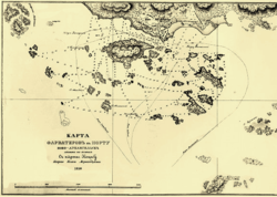
His most famous legacy is the Atlas of the Northwest Coasts of America: from Bering Strait to Cape Corrientes and the Aleutian Islands published in 1852. The 39 maps of this atlas were engraved at Sitka by Kozma Terentev (or Terentief), a Russian-Alaskan creole around 1849.
Besides Tebenkof Bay, other geographic features of Alaska, like Tebenkof Glacier, Mount Tebenkof and Point Tebenkof have been named after Captain Mikhail Tebenkov.
Works
- Atlas sieverozapadnykh beregov Ameriki. Sitka 1872.
- Gidrograticheskiia zamiechaniia k Atlas sieverozapadnykh beregov Ameriki. Sitka 1872.