

Mobile-Tensaw River Delta
Encyclopedia
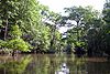
River delta
A delta is a landform that is formed at the mouth of a river where that river flows into an ocean, sea, estuary, lake, reservoir, flat arid area, or another river. Deltas are formed from the deposition of the sediment carried by the river as the flow leaves the mouth of the river...
and wetland
Wetland
A wetland is an area of land whose soil is saturated with water either permanently or seasonally. Wetlands are categorised by their characteristic vegetation, which is adapted to these unique soil conditions....
in Alabama
Alabama
Alabama is a state located in the southeastern region of the United States. It is bordered by Tennessee to the north, Georgia to the east, Florida and the Gulf of Mexico to the south, and Mississippi to the west. Alabama ranks 30th in total land area and ranks second in the size of its inland...
. It encompasses approximately 260000 acres (105,218.4 ha) in a 40 by 10 miles (16.1 km) area and is the second largest delta in the United States
United States
The United States of America is a federal constitutional republic comprising fifty states and a federal district...
.
The delta is formed by the confluence of the Tombigbee
Tombigbee River
The Tombigbee River is a tributary of the Mobile River, approximately 200 mi long, in the U.S. states of Mississippi and Alabama. It is one of two major rivers, along with the Alabama River, that unite to form the short Mobile River before it empties into Mobile Bay on the Gulf of Mexico...
and Alabama
Alabama River
The Alabama River, in the U.S. state of Alabama, is formed by the Tallapoosa and Coosa rivers, which unite about north of Montgomery.The river flows west to Selma, then southwest until, about from Mobile, it unites with the Tombigbee, forming the Mobile and Tensaw rivers, which discharge into...
rivers, encompasses the converging Coosa
Coosa River
The Coosa River is a tributary of the Alabama River in the U.S. states of Alabama and Georgia. The river is about long altogether.The Coosa River is one of Alabama's most developed rivers...
and Black Warrior
Black Warrior River
The Black Warrior River is a waterway in west central Alabama in the southeastern United States. The river rises in the extreme southern edges of the Appalachian Highlands and flows 178 miles to the Tombigbee River, of which the Black Warrior is the primary tributary...
rivers, and is southerly-bound by the Causeway
Battleship Parkway
Battleship Parkway, commonly referred to locally and in the media as the "Causeway", is an elevated long causeway that carries US 90 and US 98 eastbound across Mobile Bay from the Bankhead Tunnel in Mobile, Alabama to Spanish Fort, Alabama. The roadway itself is a four-lane divided highway for...
as it ultimately opens into the head of Mobile Bay
Mobile Bay
Mobile Bay is an inlet of the Gulf of Mexico, lying within the state of Alabama in the United States. Its mouth is formed by the Fort Morgan Peninsula on the eastern side and Dauphin Island, a barrier island on the western side. The Mobile River and Tensaw River empty into the northern end of the...
through Mobile
Mobile River
The Mobile River is located in southern Alabama in the United States. Formed out of the confluence of the Tombigbee and Alabama rivers, the approximately river drains an area of of Alabama, with a watershed extending into Mississippi, Georgia, and Tennessee. Its drainage basin is the...
, Tensaw
Tensaw River
The Tensaw River is a distributary of the Mobile River, approximately 36 mi long, in southern Alabama in the United States. It is formed as a bayou of the Mobile approximately 6 mi south of the formation of the Mobile by the confluence of the Tombigbee and Alabama rivers...
, Apalachee
Apalachee River
The Apalachee River is a tributary of the Oconee River in the U.S. state of Georgia. It rises north of Lawrenceville in eastern Gwinnett County and flows southeast to join the Oconee River in Lake Oconee west of Greensboro.- References :...
, and Blakeley rivers. It is contained within sections of Baldwin
Baldwin County, Alabama
-2010:Whereas according to the 2010 U.S. Census Bureau:*85.7% White*9.4% Black*0.7% Native American*0.7% Asian*0.0% Native Hawaiian or Pacific Islander*1.5% Two or more races*4.4% Hispanic or Latino -2000:...
, Clarke
Clarke County, Alabama
-2010:Whereas according to the 2010 U.S. Census Bureau:*54.5% White*43.9% Black*0.4% Native American*0.3% Asian*0.0% Native Hawaiian or Pacific Islander*0.7% Two or more races*1.0% Hispanic or Latino -2000:...
, Mobile
Mobile County, Alabama
Mobile County[p] is a county of the U.S. state of Alabama. Its name is in honor of a tribe of Indians, the Maubila tribe . As of 2011, its population was 415,704. Its county seat is Mobile, Alabama...
, Monroe
Monroe County, Alabama
Monroe County is a county of the U.S. state of Alabama. Its name is in honor of James Monroe, fifth President of the United States. As of 2010, the population was 23,068. Its county seat is Monroeville. It is a dry county, in which the sale of alcoholic beverages is restricted or...
, and Washington
Washington County, Alabama
Washington County is a county of the U.S. state of Alabama. The county was named in honor of George Washington, first President of the United States of America. As of 2010, the population was 17,581. Its county seat is Chatom. Washington County is a dry county.-History:The area was long inhabited...
counties.
Environment and Ecology
The delta is ecologically important and includes a wide variety of habitats, including MesicMesic habitat
In ecology, a mesic habitat is a type of habitat with a moderate or well-balanced supply of moisture, e.g., a mesic forest, a temperate hardwood forest, or dry-mesic prairie. Compared to a dry habitat, a mesic habitat is moister....
flood plains, cypress
Taxodium distichum
Taxodium distichum is a species of conifer native to the southeastern United States.-Characteristics:...
-gum
Tupelo
The tupelo , black gum, or pepperidge tree, genus Nyssa , is a small genus of about 9 to 11 species of trees with alternate, simple leaves...
swamp
Swamp
A swamp is a wetland with some flooding of large areas of land by shallow bodies of water. A swamp generally has a large number of hammocks, or dry-land protrusions, covered by aquatic vegetation, or vegetation that tolerates periodical inundation. The two main types of swamp are "true" or swamp...
s, tidal brackish water
Brackish water
Brackish water is water that has more salinity than fresh water, but not as much as seawater. It may result from mixing of seawater with fresh water, as in estuaries, or it may occur in brackish fossil aquifers. The word comes from the Middle Dutch root "brak," meaning "salty"...
marsh
Marsh
In geography, a marsh, or morass, is a type of wetland that is subject to frequent or continuous flood. Typically the water is shallow and features grasses, rushes, reeds, typhas, sedges, other herbaceous plants, and moss....
es, bottomland forests
Bottomland hardwood forest
The Bottomland hardwood forest is a type of deciduous hardwood forest found in broad lowland floodplains along large rivers and lakes. They are occasionally flooded, which builds up the alluvial soils required for the Gum, Oak and Bald Cypress trees that typically grow in this type of biome...
and submersed grassbeds. It is home to some of the most diverse wildlife in Alabama including 126 species of fish, 46 mammals, 69 reptiles, 30 amphibians and at least 300 species of bird, including more than 110 which nest in the region.
Natural history
The delta lies in a river valley which began forming several million years ago. Many separate inland streams joined as they flowed southward across land which was once covered by the Gulf of MexicoGulf of Mexico
The Gulf of Mexico is a partially landlocked ocean basin largely surrounded by the North American continent and the island of Cuba. It is bounded on the northeast, north and northwest by the Gulf Coast of the United States, on the southwest and south by Mexico, and on the southeast by Cuba. In...
. By the end of the last major ice age
Ice age
An ice age or, more precisely, glacial age, is a generic geological period of long-term reduction in the temperature of the Earth's surface and atmosphere, resulting in the presence or expansion of continental ice sheets, polar ice sheets and alpine glaciers...
(approximately 18,000 years ago), when the sea level was much lower and Alabama's coastline was about 60 miles (96.6 km) south of its present location, the waterways of the delta valley extended much farther than their current-day southern termination at the head of Mobile Bay. As the ice age ended and global temperatures increased, sea levels began to rise again to their present-day level.
History
Humans inhabited the delta region at least as far back as 5,000 years ago.During the 14th century, Indians of the Mississippian period built earthen mounds along Bottle Creek
Bottle Creek Indian Mounds
Bottle Creek Indian Mounds is an archaeological site located on a low swampy island within the Mobile-Tensaw River Delta near Mobile, Alabama, United States...
and the Tensaw River. In time, other peoples moved into the area, including the Taensas, the Creeks, and the Choctaws.
In the 16th century the area was visited by Spanish forces and was again visited in the early 18th century by the French, at which time early-Mobile
Old Mobile Site
The Old Mobile Site was the location of the French settlement La Mobile and the associated Fort Louis de La Louisiane, in the French colony of New France in North America, from 1702 until 1712. The site is located in Le Moyne, Alabama, on the Mobile River in the Mobile-Tensaw River Delta...
was first settled.
The delta was also the site of the Fort Mims massacre
Fort Mims massacre
The Fort Mims massacre occurred on 30 August 1813, when a force of Creek people, belonging to the "Red Sticks" faction under the command of Peter McQueen and William Weatherford "Red Eagle", his cousin by marriage, killed hundreds of settlers, mixed-blood Creeks, and militia at Fort Mims...
which occurred in the early 19th century, as well as the last important battle of the American Civil War
American Civil War
The American Civil War was a civil war fought in the United States of America. In response to the election of Abraham Lincoln as President of the United States, 11 southern slave states declared their secession from the United States and formed the Confederate States of America ; the other 25...
, which took place at the fortified town of Blakeley
Blakeley, Alabama
Blakeley is a ghost town in Baldwin County, Alabama, United States. It was the location of a major fort during the Civil War. The town is now in an Alabama historic state park known as Historic Blakeley State Park near Spanish Fort....
located on the rim of the delta.
In the mid-1920s, the Causeway
Battleship Parkway
Battleship Parkway, commonly referred to locally and in the media as the "Causeway", is an elevated long causeway that carries US 90 and US 98 eastbound across Mobile Bay from the Bankhead Tunnel in Mobile, Alabama to Spanish Fort, Alabama. The roadway itself is a four-lane divided highway for...
was built across the lowest part of the delta, connecting the western and eastern shores of Mobile Bay. Later, I-65, I-10 and a railway line were constructed to span different parts of the area.
The delta was designated a National Natural Landmark
National Natural Landmark
The National Natural Landmark program recognizes and encourages the conservation of outstanding examples of the natural history of the United States. It is the only natural areas program of national scope that identifies and recognizes the best examples of biological and geological features in...
in May 1974.
Recreation
BoatingBoating
Boating is the leisurely activity of travelling by boat, or the recreational use of a boat whether powerboats, sailboats, or man-powered vessels , focused on the travel itself, as well as sports activities, such as fishing or water skiing...
and fishing
Fishing
Fishing is the activity of trying to catch wild fish. Fish are normally caught in the wild. Techniques for catching fish include hand gathering, spearing, netting, angling and trapping....
are popular in the Mobile Delta. Boat ramps and water access points are abundant throughout the area. The Bartram Canoe Trail
Bartram Canoe Trail
The Bartram Canoe Trail is a system of canoe and kayak trails in the Mobile-Tensaw River Delta and is named for explorer and naturalist William Bartram....
provides a system of waterways by which boaters may explore the delta. The area is known for its excellent bird watching.
Hunting
Hunting
Hunting is the practice of pursuing any living thing, usually wildlife, for food, recreation, or trade. In present-day use, the term refers to lawful hunting, as distinguished from poaching, which is the killing, trapping or capture of the hunted species contrary to applicable law...
is also a common pastime.