

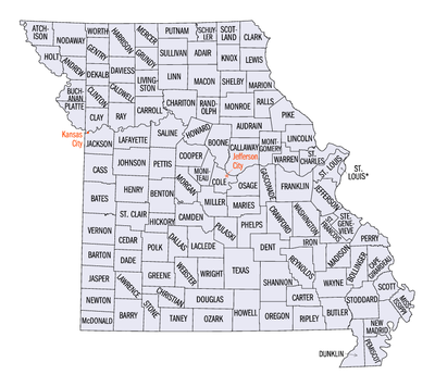
Missouri census statistical areas
Encyclopedia
The United States Census Bureau
has defined 3 Combined Statistical Area
s (CSAs), 8 Metropolitan Statistical Areas (MSAs), and 20 Micropolitan Statistical Areas (μSAs) in the State of Missouri. The following table describes these areas with the following information:
United States Census Bureau
The United States Census Bureau is the government agency that is responsible for the United States Census. It also gathers other national demographic and economic data...
has defined 3 Combined Statistical Area
Combined Statistical Area
The United States Office of Management and Budget defines micropolitan and metropolitan statistical areas. Metropolitan and micropolitan statistical areas consist of one or more counties...
s (CSAs), 8 Metropolitan Statistical Areas (MSAs), and 20 Micropolitan Statistical Areas (μSAs) in the State of Missouri. The following table describes these areas with the following information:
- The name of the Combined Statistical Area (CSA), if any.
- The population of the CSA as of 2008-07-01, as estimated by the United States Census Bureau.
- The name of the Core Based Statistical AreaCore based statistical areaA Core Based Statistical Area is a U.S. geographic area defined by the Office of Management and Budget based around an urban center of at least 10,000 people and adjacent areas that are socioeconomically tied to the urban center by commuting. Areas defined on the basis of these standards applied...
(CBSA). - The population of the CBSA as of 2008-07-01, as estimated by the United States Census Bureau.
- The name of the countyCounty (United States)In the United States, a county is a geographic subdivision of a state , usually assigned some governmental authority. The term "county" is used in 48 of the 50 states; Louisiana is divided into parishes and Alaska into boroughs. Parishes and boroughs are called "county-equivalents" by the U.S...
or independent cityIndependent cityAn independent city is a city that does not form part of another general-purpose local government entity. These type of cities should not be confused with city-states , which are fully sovereign cities that are not part of any other sovereign state.-Historical precursors:In the Holy Roman Empire,...
. - The population of the county or independent city as of 2008-07-01, as estimated by the United States Census Bureau.
| Combined Statistical Area | 2008 Pop | Core Based Statistical Area | 2008 Pop | County | 2008 Pop |
|---|---|---|---|---|---|
| St. Louis-St. Charles-Farmington, MO-IL CSA | 2,879,924 2,185,926 |
St. Louis, MO-IL MSA | 2,816,710 2,122,712 |
St. Louis County, Missouri St. Louis County, Missouri St. Louis County is a county located in the U.S. state of Missouri. Its county seat is Clayton. St. Louis County is part of the St. Louis Metro Area wherein the independent City of St. Louis and its suburbs in St. Louis County, as well as the surrounding counties in both Missouri and Illinois all... |
991,830 |
| St. Louis City St. Louis, Missouri St. Louis is an independent city on the eastern border of Missouri, United States. With a population of 319,294, it was the 58th-largest U.S. city at the 2010 U.S. Census. The Greater St... |
354,361 | ||||
| St. Charles County, Missouri | 360,485 | ||||
| Madison County, Illinois Madison County, Illinois Madison County is a county located in the U.S. state of Illinois. Madison County is part of the Metro-East region of the St. Louis Metro Area. According to the 2010 census, it has a population of 269,282, which is an increase of 4.0% from 258,941 in 2000. The county seat is Edwardsville, home to... |
267,038 | ||||
| St. Clair County, Illinois St. Clair County, Illinois St. Clair County is a county located in the U.S. state of Illinois. In 1970, the U.S. Census Bureau placed the mean center of U.S. population in St. Clair County. According to the 2010 census, it has a population of 270,056, which is an increase of 5.5% from 256,082 in 2000. Its county seat is... |
261,409 | ||||
| Jefferson County, Missouri Jefferson County, Missouri Jefferson County is a county located in East Central Missouri in the United States. The county was included as the mean center of U.S. population in 1980. It is the sixth most-populous county in Missouri. Census 2010 put the population at 218,733 Its county seat is Hillsboro. The county was... |
217,679 | ||||
| Franklin County, Missouri Franklin County, Missouri Franklin County is a county located in the U.S. state of Missouri on the south side of the Missouri River. Franklin County is part of the St. Louis Metro Area and contains many of the St. Louis exurbs. Census 2010 put the population at 101,492; making it the 10th most populous county in Missouri.... |
100,898 | ||||
| Lincoln County, Missouri Lincoln County, Missouri As of the census of 2000, there were 38,944 people, 13,851 households, and 10,554 families residing in the county. The population density was 62 people per square mile . There were 15,511 housing units at an average density of 25 per square mile... |
52,775 | ||||
| Macoupin County, Illinois Macoupin County, Illinois Macoupin County is a county located in the southwestern portion of the U.S. state of Illinois. According to the 2010 census, it has a population of 47,765, which is a decrease of 2.6% from 49,019 in 2000. The county seat is Carlinville. Macoupin County is an outlying county of the Metro-East region... |
48,143 | ||||
| Clinton County, Illinois Clinton County, Illinois -Demographics: As of the census of 2000, there were 35,535 people, 12,754 households, and 9,221 families residing in the county. The population density was 75 people per square mile . There were 13,805 housing units at an average density of 29 per square mile... |
36,470 | ||||
| Monroe County, Illinois Monroe County, Illinois Monroe County is a county located in the U.S. state of Illinois. According to the 2010 census, it has a population of 32,957, which is an increase of 19.3% from 27,619 in 2000. Its county seat is Waterloo... |
32,335 | ||||
| Warren County, Missouri Warren County, Missouri Warren County is a county located in the U.S. state of Missouri. Warren County is part of the St. Louis Metro Area and is located west of the city on the north side of the Missouri River. As of 2008, the population was estimated to be 31,214. Its county seat is Warrenton... |
31,214 | ||||
| Washington County, Missouri Washington County, Missouri Washington County is a county located in East Central Missouri in the United States. As of the 2010 U.S. Census, the county's population was 25,195. The largest city and county seat is Potosi... |
24,548 | ||||
| Jersey County, Illinois Jersey County, Illinois Jersey County is a county located in the U.S. state of Illinois. Jersey County is part of the St. Louis Metropolitan Area. According to the 2010 census, it has a population of 22,985, which is an increase of 6.1% from 21,668 in 2000... |
22,451 | ||||
| Bond County, Illinois Bond County, Illinois Bond County is a county located in the U.S. state of Illinois. It is part of the St. Louis Metro Area. According to the 2010 census, it has a population of 17,768, which is an increase of 0.8% from 17,633 in 2000. Its county seat is Greenville, Illinois.... |
18,253 | ||||
| Calhoun County, Illinois Calhoun County, Illinois Calhoun County is a county located in the U.S. state of Illinois. According to the 2010 census, it has a population of 5,089, which is an increase of 0.1% from 5,084 in 2000. Its county seat is Hardin. It is part of the Metro-East portion of the St... |
5,101 | ||||
| Farmington, MO μSA | 63,214 | St. Francois County, Missouri | 63,214 | ||
| Kansas City-Overland Park-Kansas City, MO-KS CSA | 2,059,328 1,224,240 |
Kansas City, MO-KS MSA | 1,990,831 1,172,224 |
Jackson County, Missouri Jackson County, Missouri Jackson County is a county located in the U.S. state of Missouri. With a population of 674,158 in the 2010 census, Jackson County is the second most populous of Missouri's counties, after St. Louis County. Kansas City, the state's most populous city and focus city of the Kansas City Metropolitan... |
668,417 |
| Johnson County, Kansas Johnson County, Kansas Johnson County is a county located in northeast Kansas, in the central United States. The county is largely suburban, being part of the Kansas City metropolitan area, and containing many of its affluent southwestern suburbs. As of the 2010 census, the county population was 544,179. Its county... |
524,723 | ||||
| Clay County, Missouri | 215,707 | ||||
| Wyandotte County, Kansas Wyandotte County, Kansas Wyandotte County is a county located in northeast Kansas, in the Central United States. The county's population was 157,505 for the 2010 census. Its county seat and most populous city is Kansas City with which it shares a unified government... |
153,698 | ||||
| Cass County, Missouri Cass County, Missouri Cass County is a county located in the U.S. state of Missouri. As of 2010, the population was 99,478. Its county seat is Harrisonville. The county was organized in 1835 as "Van Buren County", renamed in 1848 after Michigan U.S... |
98,429 | ||||
| Platte County, Missouri Platte County, Missouri As of the census of 2000, there were 73,781 people, 29,278 households, and 20,231 families residing in the county. The population density was 176 people per square mile . There were 30,902 housing units at an average density of 74 per square mile... |
85,896 | ||||
| Leavenworth County, Kansas Leavenworth County, Kansas Leavenworth County is a county located in Northeast Kansas, in the Central United States. As of the 2010 census, the county population was 76,227. Its county seat and most populous city is Leavenworth... |
73,438 | ||||
| Lafayette County, Missouri | 32,913 | ||||
| Miami County, Kansas Miami County, Kansas Miami County is a county located in East Central Kansas, in the Central United States. As of the 2010 census, the county population was 32,787. Its county seat and most populous city is Paola... |
30,710 | ||||
| Franklin County, Kansas Franklin County, Kansas Franklin County is a county located in East Central Kansas, in the Central United States. As of the 2010 census, the county population was 25,992. Its county seat and most populous city is Ottawa... |
26,422 | ||||
| Ray County, Missouri | 23,445 | ||||
| Clinton County, Missouri Clinton County, Missouri As of the census of 2000, there were 18,979 people, 7,152 households, and 5,299 families residing in the county. The population density was 45 people per square mile . There were 7,877 housing units at an average density of 19 per square mile... |
21,094 | ||||
| Bates County, Missouri Bates County, Missouri Bates County is a county located in the U.S. state of Missouri. As of 2000, the population is 16,653. Its county seat is Butler. The county was organized in 1833 and named after Frederick Bates, the second governor of Missouri.... |
17,075 | ||||
| Linn County, Kansas Linn County, Kansas Linn County is a county located in East Central Kansas, in the Central United States. As of the 2010 census, the county population was 9,656. Its county seat is Mound City, and its most populous city is Pleasanton... |
9,616 | ||||
| Caldwell County, Missouri Caldwell County, Missouri Caldwell County is a county located in the U.S. state of Missouri. , the population was 8,969. Its county seat is Kingston. The county was organized in 1836 as a haven for the Mormons, who had been previously driven from Jackson County, Missouri in November of 1833 and had been refugees in... |
9,248 | ||||
| Warrensburg, MO μSA | 52,016 | Johnson County, Missouri Johnson County, Missouri Johnson County is a county located in the U.S. state of Missouri. As of 2010, the population was 52,595. Its county seat is Warrensburg. The county was formed 13 December 1834 from Lafayette County and was named for Vice President Richard M... |
52,016 | ||
| Atchison, KS μSA | 16,481 | Atchison County, Kansas Atchison County, Kansas Atchison County is a county located in Northeast Kansas, in the Central United States. As of the 2010 census, the county population was 16,924. Its county seat and most populous city is Atchison. The county is named in honor of David Rice Atchison, a United States Senator from Missouri... |
16,481 | ||
| primary census statistical area | 426,144 | Springfield, MO MSA | 426,144 | Greene County, Missouri Greene County, Missouri Greene County is a county located in Southwest Missouri. As of 2010, the population was 275,174 making it the fourth most populated county in Missouri. Its county seat is Springfield... |
266,944 |
| Christian County, Missouri Christian County, Missouri Christian County is a county located in Southwest Missouri. The county had a population of 54,285 in 2000 census. According to the 2010 census, the county's population is 77,422 , making it the fastest growing county in Missouri and one of the fastest growing in the nation as the county becomes... |
75,479 | ||||
| Webster County, Missouri Webster County, Missouri Webster County is a county located in Southwest Missouri. As of 2000, the population was 31,045. The population in 2010 was 36,202. Its county seat is Marshfield. The county was organized in 1855 and named for U.S. Senator and U.S... |
36,473 | ||||
| Polk County, Missouri Polk County, Missouri Polk County is a county located in the U.S. state of Missouri. As of 2010, the population was 31,137. Its county seat is Bolivar.Polk County is part of the Springfield, Missouri, Metropolitan Statistical Area.- History :... |
30,404 | ||||
| Dallas County, Missouri | 16,844 | ||||
| primary census statistical area | 172,933 | Joplin, MO MSA | 172,933 | Jasper County, Missouri Jasper County, Missouri Jasper County is a county located in the US state of Missouri. It is included in the Joplin, Missouri Metropolitan Statistical Area. The 2010 total population of Jasper County was 117,404. It is the ninth most populous county in Missouri. Its county seat is Carthage, making it one of the few... |
116,813 |
| Newton County, Missouri | 56,120 | ||||
| primary census statistical area | 164,283 | Columbia, MO MSA | 164,283 | Boone County, Missouri Boone County, Missouri Boone County is a county centrally located in the U.S. state of Missouri. It is the eighth most populous county in Missouri. In 2010, the population was 162,642. Its county seat, Columbia, is the fifth largest city in Missouri and the anchor city of the Columbia Metropolitan Area.-History:Boone... |
154,365 |
| Howard County, Missouri | 9,918 | ||||
| primary census statistical area | 146,363 | Jefferson City, MO MSA | 146,363 | Cole County, Missouri | 74,313 |
| Callaway County, Missouri Callaway County, Missouri Callaway County is a county located in the U.S. state of Missouri. It is part of the Jefferson City, Missouri Metropolitan Statistical Area. As of 2010, the population was 44,332. Its county seat is Fulton. The county was organized in 1820. It was named for Capt. James Callaway, a grandson of... |
43,464 | ||||
| Moniteau County, Missouri | 15,121 | ||||
| Osage County, Missouri Osage County, Missouri Osage County is a county located in the U.S. state of Missouri. The county was named for the Osage River. As of 2000, the population was 13,062. Its county seat is Linn. The center of population of Missouri is located in Osage County, in the city of Westphalia .Osage County is part of the... |
13,465 | ||||
| Cape Girardeau-Sikeston-Jackson, MO-IL CSA | 134,058 125,906 |
Cape Girardeau-Jackson, MO-IL μSA | 93,385 85,233 |
Cape Girardeau County, Missouri Cape Girardeau County, Missouri Cape Girardeau County is a county located in Southeast Missouri in the United States. As of the 2010 U.S. Census, the county's population was 75,764. While the largest city in the county is Cape Girardeau, the county seat is actually Jackson, which was the first city named in honor of President... |
73,243 |
| Bollinger County, Missouri Bollinger County, Missouri Bollinger County is a county located in Southeast Missouri in the United States. As of the 2010 U.S. Census, the county's population was 12,363; despite a 2009 estimate that showed the population to be 11,841. The county seat is Marble Hill, which is the only city in Bollinger County... |
11,990 | ||||
| Alexander County, Illinois Alexander County, Illinois Alexander County is a county located in the U.S. state of Illinois. According to the 2010 census, it has a population of 8,238, which is a decrease of 14.1% from 9,590 in 2000. Its county seat is Cairo. Alexander County is part of the Cape Girardeau–Jackson, MO-IL Metropolitan Statistical... |
8,152 | ||||
| Sikeston, MO μSA | 40,673 | Scott County, Missouri Scott County, Missouri Scott County is a county located in Southeast Missouri in the United States. As of the 2000 U.S. Census, the population was 40,422; a 2008 estimate, however, showed the population to be 40,673. Its county seat is Benton... |
40,673 | ||
| primary census statistical area | 126,359 118,606 |
St. Joseph, MO-KS MSA | 126,359 118,606 |
Buchanan County, Missouri Buchanan County, Missouri Buchanan County is a county located in the U.S. state of Missouri. As of 2010, the population was 89,201. Its county seat is Saint Joseph. When originally formed in 1838, the county was named Roberts County, after settler Hiram Roberts; it was renamed in 1839 for James Buchanan, then a U.S.... |
89,408 |
| Andrew County, Missouri Andrew County, Missouri -External links:* from University of Missouri Division of Special Collections, Archives, and Rare Books... |
16,923 | ||||
| DeKalb County, Missouri DeKalb County, Missouri DeKalb County is a county located in the U.S. state of Missouri. As of 2010, the population is 12,892. The county was organized in 1845 and is named after the American Revolutionary War general Johann de Kalb. The county along with Buchanan and Andrew counties in Missouri and Doniphan County,... |
12,275 | ||||
| Doniphan County, Kansas Doniphan County, Kansas Doniphan County is a county located in Northeast Kansas, in the Central United States. As of the 2010 census, the county population was 7,945. Its county seat is Troy and its most populous city is Wathena. The county along with Buchanan, Andrew, and DeKalb counties in Missouri is included in... |
7,753 | ||||
| primary census statistical area | 78,574 | Branson, MO μSA | 78,574 | Taney County, Missouri Taney County, Missouri Taney County is a county located in Southwest Missouri in the United States. As of the 2000 U.S. Census, the county's population was 39,703. In the 2010 census the counties population was 51,675 Its county seat is Forsyth.... |
47,023 |
| Stone County, Missouri Stone County, Missouri Stone County is a county located in Southwest Missouri in the United States. As of the 2010 U.S. Census, the county's population was 32,202. Its county seat is Galena... |
31,551 | ||||
| primary census statistical area | 44,546 | Fort Leonard Wood, MO μSA | 44,546 | Pulaski County, Missouri Pulaski County, Missouri Pulaski County is a county located in the U.S. state of Missouri. The county was organized in 1833 and named for Kazimierz Pułaski, Polish patriot who died fighting in the American Revolution. As of 2010, the population was 52,274, an increase of 27% from the 2000 Census count of 41,165. Its... |
44,546 |
| primary census statistical area | 42,205 | Rolla, MO μSA | 42,205 | Phelps County, Missouri Phelps County, Missouri Phelps County is a county located in south-central Missouri in the United States.According to the U.S. Census Bureau, it includes the mean center of U.S. population in 2000. As of the 2000 U.S. Census, the county's population was 39,825. A 2008 estimate, however, showed the population to be 42,205.... |
42,205 |
| primary census statistical area | 41,383 | Poplar Bluff, MO μSA | 41,383 | Butler County, Missouri Butler County, Missouri Butler County is a county located in the southeast Ozark Foothills Region in Southeast Missouri in the United States. As of the 2010 U.S. Census, the county's population was 42,794. The largest city and county seat is Poplar Bluff. The county was officially organized from Wayne County on February... |
41,383 |
| primary census statistical area | 41,006 | Sedalia, MO μSA | 41,006 | Pettis County, Missouri Pettis County, Missouri Pettis County is a county located in the U.S. state of Missouri. The county was organized in 1833 and is named for U.S. Congressman Spencer Darwin Pettis. As of 2000, the population was 39,403... |
41,006 |
| primary census statistical area | 39,000 | West Plains, MO μSA | 39,000 | Howell County, Missouri Howell County, Missouri Howell County is a county located in South Central Missouri in the United States. As of the 2010 U.S. Census, the county's population was 40,400. The largest city and county seat is West Plains... |
39,000 |
| primary census statistical area | 38,057 | Hannibal, MO μSA | 38,057 | Marion County, Missouri | 28,225 |
| Ralls County, Missouri | 9,832 | ||||
| primary census statistical area | 35,524 | Lebanon, MO μSA | 35,524 | Laclede County, Missouri Laclede County, Missouri Laclede County is a county located in the U.S. state of Missouri. As of 2000, the population was 32,513. Its county seat is Lebanon. The county was organized February 24, 1849, and was named after Pierre Laclède, founder of St... |
35,524 |
| primary census statistical area | 31,454 | Kennett, MO μSA | 31,454 | Dunklin County, Missouri Dunklin County, Missouri Dunklin County is a county located in the Bootheel of Southeast Missouri in the United States. As of the 2000 U.S. Census, the county's population was 33,155. A 2008 estimate, however, showed the population to be 31,454. The largest city and county seat is Kennett... |
31,454 |
| primary census statistical area | 29,053 | Kirksville, MO μSA | 29,053 | Adair County, Missouri Adair County, Missouri Adair County is a county located in northeast Missouri. As of 2010, the population was 25,607. Its county seat is Kirksville. The county was organized in 1841 and is named in honor of Kentucky Governor John Adair.... |
24,943 |
| Schuyler County, Missouri | 4,110 | ||||
| primary census statistical area | 26,049 | Mexico, MO μSA | 26,049 | Audrain County, Missouri Audrain County, Missouri Audrain County is a county located in the U.S. state of Missouri. As of 2010, the population was 25,529. Its county seat is Mexico. The county was organized in 1836. Audrain County was named for Col. James Hunter Audrain. Col. Audrain was Colonel of militia in the War of 1812. In 1830 Col... |
26,049 |
| primary census statistical area | 25,723 | Moberly, MO μSA | 25,723 | Randolph County, Missouri | 25,723 |
| primary census statistical area | 433,890 22,731 |
Fayetteville-Springdale-Rogers, AR-MO MSA | 433,890 22,731 |
Benton County, Arkansas Benton County, Arkansas Benton County is a county located in the U.S. state of Arkansas. As of the 2000 census, the population was 153,406. The U.S. Census Bureau 2010 population is 221,339. The county seat is Bentonville. Benton County was formed on 30 September 1836 and was named after Thomas Hart Benton, a U.S... |
202,363 |
| Washington County, Arkansas Washington County, Arkansas Washington County is a county located in the northwest part of the U.S. state of Arkansas. As of 2010, the population was 203,065. The county seat is Fayetteville. Washington County is Arkansas's 17th county, formed on October 17, 1828, and named for George Washington, the first President of the... |
193,145 | ||||
| McDonald County, Missouri McDonald County, Missouri McDonald County is a county located in Southwest Missouri in the United States of America. As of the 2010 U.S. Census, the population was 23,083. Its county seat is Pineville... |
22,731 | ||||
| Madison County, Arkansas Madison County, Arkansas Madison County is a county located in the U.S. state of Arkansas. As of 2010, the population was 15,717. The county seat is Huntsville. The county was formed on September 30, 1836, and named for James Madison, President of the United States... |
15,651 | ||||
| primary census statistical area | 22,505 | Marshall, MO μSA | 22,505 | Saline County, Missouri | 22,505 |
| primary census statistical area | 22,054 | Maryville, MO μSA | 22,054 | Nodaway County, Missouri Nodaway County, Missouri Nodaway County is a county located in the U.S. state of Missouri. The county was organized in 1845 and named for the Nodaway River.As of 2010, the population was 23,370... |
22,054 |
| primary census statistical area | 76,817 9,951 |
Quincy, IL-MO μSA | 76,817 9,951 |
Adams County, Illinois Adams County, Illinois Adams County is the westernmost county of the U.S. state of Illinois. According to the 2010 census, it has a population of 67,103, which is a decrease of 1.7% from 68,277 in 2000... |
66,866 |
| Lewis County, Missouri | 9,951 | ||||
| primary census statistical area | 42,844 7,180 |
Fort Madison-Keokuk, IA-MO μSA | 42,844 7,180 |
Lee County, Iowa Lee County, Iowa -2010 census:The 2010 census recorded a population of 35,862 in the county, with a population density of . There were 16,205 housing units, of which 14,610 were occupied.-2000 census:... |
35,664 |
| Clark County, Missouri Clark County, Missouri Clark County is a county located in the U.S. state of Missouri. As of 2010, the population was 7,139. Its county seat is Kahoka. The county was organized in 1836 and named after William Clark, leader of the Lewis and Clark Expedition and later a Governor of Missouri Territory.Clark County is part... |
7,180 | ||||
| none | Camden County, Missouri Camden County, Missouri Camden County is a county located in the U.S. state of Missouri. As of 2000, the population was 37,051. Its county seat is Camdenton. The county was organized in 1841 as Kinderhook County and renamed in 1843, for Charles Pratt, 1st Earl Camden, Chancellor of England, and leader of the Whig... |
40,664 | |||
| Lawrence County, Missouri | 37,757 | ||||
| Barry County, Missouri Barry County, Missouri Barry County is a county located in the U.S. state of Missouri. As of 2010, the population was 35,597. Its county seat is Cassville. The county was organized in 1835 and named after William Taylor Barry from Kentucky, a United States Postmaster General.... |
36,301 | ||||
| Stoddard County, Missouri Stoddard County, Missouri Stoddard County is a county located in Southeast Missouri in the United States. As of the 2000 U.S. Census, the population was 29,705. A 2008 estimate, however, showed the population to be 29,537. The county seat is Bloomfield while the largest city in the county is Dexter... |
29,537 | ||||
| Miller County, Missouri | 24,949 | ||||
| Texas County, Missouri Texas County, Missouri Texas County is a county located in South Central Missouri in the United States. As of the 2010 census, the county's population was 26,008. It's county seat is Houston. The county was organized in 1843 as Ashley County, changing its name in 1845 to Texas, after the Republic of Texas. The 2010 U.S... |
24,598 | ||||
| Crawford County, Missouri Crawford County, Missouri -State:In the Missouri House of Representatives, most of Crawford County is included within the 150th Legislative District and is currently represented by State Representative Jason T. Smith . In 2008, Smith defeated Democratic challenger James D. Ellis 69.97-30.03 percent; the Crawford County... |
23,970 | ||||
| Henry County, Missouri Henry County, Missouri Henry County is a county located in the U.S. state of Missouri. As of 2000, the population was 21,997. Its county seat is Clinton. The county was organized in 1835 as Rives County, and renamed in 1841 after the American patriot Patrick Henry, of Virginia. The county was originally named after... |
22,179 | ||||
| Morgan County, Missouri Morgan County, Missouri Morgan County is a county located in the U.S. state of Missouri. As of July 2007, the population was 20,820. Its county seat is Versailles.-History :... |
20,861 | ||||
| Vernon County, Missouri | 20,009 | ||||
| Perry County, Missouri Perry County, Missouri Perry County is a county located in Southeast Missouri in the United States. As of the 2000 U.S. Census, the county's population was 18,132. In 2008 the population was estimated to be 18,743. Its county seat is Perryville. The county was officially organized on November 16, 1820 from Ste... |
18,743 | ||||
| Pemiscot County, Missouri Pemiscot County, Missouri Pemiscot County is a county located in the Bootheel in Southeast Missouri in the United States. As of the 2000 U.S. Census, the county's population was 20,047. A 2008 estimate, however, showed the population to be 18,515. The largest city and county seat is Caruthersville... |
18,515 | ||||
| Pike County, Missouri Pike County, Missouri As of the census of 2010, there were 18,516 people, 6,451 households, and 4,476 families residing in the county. The population density was 27 people per square mile . There were 7,493 housing units at an average density of 11 per square mile... |
18,476 | ||||
| Wright County, Missouri Wright County, Missouri Wright County is a county located in South Central Missouri in the United States. As of the 2010 U.S. Census, the county's population was 18,815. Its county seat is Hartville. The county was officially organized on January 29, 1841, and is named after Silas Wright , a former Congressman, U.S... |
18,443 | ||||
| Benton County, Missouri | 18,349 | ||||
| Ste. Genevieve County, Missouri | 17,720 | ||||
| New Madrid County, Missouri New Madrid County, Missouri New Madrid County is a county located in the Bootheel of southeast Missouri in the United States. As of the 2000 Census, the county's population was 19,760. A 2008 estimate, however, showed the population to be 17,589. The largest city and county seat is New Madrid... |
17,589 | ||||
| Cooper County, Missouri Cooper County, Missouri Cooper County is a county located in the U.S. state of Missouri. In 2010, the population was 17,601. Its county seat is Boonville. The county was organized in 1818 and is named for Sarshall Cooper, a frontier settler who was killed by Indians near Arrow Rock in 1814.-Geography:According to the 2000... |
17,535 | ||||
| Macon County, Missouri Macon County, Missouri Macon County is a county located in the U.S. state of Missouri. As of 2010, the population was 15,566. Its county seat is Macon. The county was organized in 1837 and named for Nathaniel Macon, a North Carolina politician... |
15,621 | ||||
| Gasconade County, Missouri Gasconade County, Missouri Gasconade County is a county in the U.S. state of Missouri located on the south side of the Missouri River, which once served as the chief route of transportation in the state. Located in the area called the Missouri Rhineland, the county had a population of 15,342 as of the 2000 U.S. Census. A... |
15,261 | ||||
| Dent County, Missouri Dent County, Missouri Dent County is a county located in South Central Missouri in the United States. As of the 2000 U.S. Census, the county's population was 14,927. A 2008 estimate, however, showed the population to be 15,119. The largest city and county seat is Salem... |
15,199 | ||||
| Livingston County, Missouri | 14,213 | ||||
| Cedar County, Missouri Cedar County, Missouri Cedar County is a county located in the U.S. state of Missouri. As of 2000, the population was 13,733. Its county seat is Stockton.- Origin of name :... |
13,652 | ||||
| Mississippi County, Missouri Mississippi County, Missouri Mississippi County is a county located in the Bootheel of Southeast Missouri in the United States. As of the 2000 U.S. Census, the county's population was 13,427. A 2008 estimate, however, showed the population to be 13,504. The largest city and county seat is Charleston... |
13,504 | ||||
| Ripley County, Missouri Ripley County, Missouri Ripley County is a county located in the Ozarks of Southeast Missouri in the United States. As of the 2000 U.S. Census, the county's population was 13,509. A 2008 estimate, however, showed the population to be 13,485. The largest city and county seat is Doniphan... |
13,485 | ||||
| Douglas County, Missouri Douglas County, Missouri Douglas County is a county located in South Central Missouri in the United States. As of the 2010 U.S. Census, the county's population was 13,684. The largest city and county seat is Ava. The county was officially organized on October 29, 1857, and is named after U.S. Senator Stephen A... |
13,438 | ||||
| Wayne County, Missouri Wayne County, Missouri Wayne County is a county located in the Ozark Foothills Region of Southeast Missouri in the United States. As of the 2000 U.S. Census, the population was 13,259. A 2008 estimate, however, showed the population to be 12,652. The county seat is Greenville... |
12,652 | ||||
| Barton County, Missouri | 12,531 | ||||
| Linn County, Missouri Linn County, Missouri As of the census of 2000, there were 13,754 people, 5,697 households, and 3,760 families residing in the county. The population density was 22 people per square mile . There were 6,554 housing units at an average density of 11 per square mile... |
12,580 | ||||
| Madison County, Missouri Madison County, Missouri Madison County is a county located in the Lead Belt region in Southeast Missouri in the United States. As of the 2000 U.S. Census, the county's population was 11,800. A 2008 estimate, however, showed the population to be 12,276. Its county seat and largest city is Fredericktown... |
12,276 | ||||
| Montgomery County, Missouri Montgomery County, Missouri Montgomery County is a county located in the U.S. state of Missouri. It lies in East Central Missouri, approximately halfway between Columbia and St. Louis. As of 2000, the population was 12,136. It was named in honor of Richard Montgomery, an American Revolutionary War general killed in 1775... |
11,804 | ||||
| Oregon County, Missouri Oregon County, Missouri Oregon County is a county located in South Central Missouri in the United States. As of the 2000 U.S. Census, the county's population was 10,344. A 2008 estimate, however, showed the population to be 10,264. Its county seat is Alton... |
10,264 | ||||
| Grundy County, Missouri | 10,125 | ||||
| Iron County, Missouri Iron County, Missouri Iron County is a county located in the Lead Belt region in Southeast Missouri in the United States. As of the 2000 U.S. Census, the county's population was 10,697. A 2008 estimate, however, showed the population to be 9,918. The largest city and county seat is Ironton... |
9,918 | ||||
| Carroll County, Missouri | 9,756 | ||||
| St. Clair County, Missouri | 9,270 | ||||
| Ozark County, Missouri Ozark County, Missouri Ozark County is a county located in South Central Missouri in the United States. As of the 2000 U.S. Census, the county's population was 9,542. A 2008 estimate, however, showed the population to be 9,227. The largest city and county seat is Gainesville. From 1843 to 1845 the county was called... |
9,227 | ||||
| Monroe County, Missouri | 9,127 | ||||
| Hickory County, Missouri | 9,048 | ||||
| Maries County, Missouri | 9,046 | ||||
| Harrison County, Missouri Harrison County, Missouri As of the census of 2000, there were 8,850 people, 3,658 households, and 2,487 families residing in the county. The population density was 12 people per square mile . There were 4,316 housing units at an average density of 6 per square mile... |
8,844 | ||||
| Shannon County, Missouri Shannon County, Missouri Shannon County is a county located in South Central Missouri in the United States, and the second-largest by area in Missouri. As of the 2000 U.S. Census, the county's population was 8,324. A 2008 estimate, however, showed the population to be 8,423. Its county seat is Eminence. The county was... |
8,423 | ||||
| Daviess County, Missouri | 7,911 | ||||
| Chariton County, Missouri Chariton County, Missouri Chariton County is a county located in the U.S. state of Missouri. As of 2000, the population was 8,438. Its county seat is Keytesville. The county was organized in 1820 from part of Howard County and was named from the Chariton River.-History:... |
7,740 | ||||
| Dade County, Missouri | 7,418 | ||||
| Sullivan County, Missouri Sullivan County, Missouri Sullivan County is a county located in the U.S. state of Missouri. In 2010, the population was 6,714. Its county seat is Milan.-History:Sullivan County, Missouri encompasses of high glaciated prairie covered by steep rolling hills and numerous creeks and streams in north central Missouri... |
6,629 | ||||
| Shelby County, Missouri | 6,411 | ||||
| Reynolds County, Missouri Reynolds County, Missouri Reynolds County is a county located in the northwestern portion of the Ozark Foothills Region in Southeast Missouri in the United States. As of the 2000 U.S. Census, the county's population was 6,689. A 2008 estimate, however, showed the population to be 6,388. Its county seat is Centerville... |
6,388 | ||||
| Gentry County, Missouri Gentry County, Missouri As of the census of 2000, there were 6,861 people, 2,747 households, and 1,884 families residing in the county. The population density was 14 people per square mile . There were 3,214 housing units at an average density of 6 per square mile... |
6,185 | ||||
| Atchison County, Missouri Atchison County, Missouri Atchison County is a county located in the U.S. state of Missouri. As of 2010, the population was 5,685. Its county seat is Rock Port. The county was organized in 1845 and named for David Rice Atchison, U.S... |
6,031 | ||||
| Carter County, Missouri Carter County, Missouri Carter County is a county located in the central western portion of the Ozark Foothills Region in Southeast Missouri in the United States. The county was officially organized on March 10, 1859, and is named after Zimri A. Carter, a pioneer settler who came to Missouri from South Carolina in 1812. ... |
5,890 | ||||
| Holt County, Missouri Holt County, Missouri Holt County is a county located in the U.S. state of Missouri. The county is in the northwest part of the state. As of 2010, the population was 4,912. Its county seat is Oregon. The county was organized in 1841 and is named after the Missouri state legislator Dr... |
4,905 | ||||
| Putnam County, Missouri | 4,862 | ||||
| Scotland County, Missouri | 4,798 | ||||
| Knox County, Missouri Knox County, Missouri As of the census of 2010, there are 4,131 people in the county, organized into 1,791 households and 1,217 families. The population density is 9 people per square mile . There are 2,317 housing units at an average density of 5 per square mile... |
4,020 | ||||
| Mercer County, Missouri | 3,523 | ||||
| Worth County, Missouri | 2,039 | ||||
See also
- MissouriMissouriMissouri is a US state located in the Midwestern United States, bordered by Iowa, Illinois, Kentucky, Tennessee, Arkansas, Oklahoma, Kansas and Nebraska. With a 2010 population of 5,988,927, Missouri is the 18th most populous state in the nation and the fifth most populous in the Midwest. It...
- List of counties in Missouri
- Demographics of Missouri
- Geography of MissouriGeography of MissouriMissouri, a state near the geographical center of the United States, has three distinct physiographic divisions:* a north-western upland plain or prairie region part of the Interior Plains' Central Lowland known as the northern plains* a lowland in the extreme southeast bootheel region of...
- United StatesUnited StatesThe United States of America is a federal constitutional republic comprising fifty states and a federal district...
- United States Census BureauUnited States Census BureauThe United States Census Bureau is the government agency that is responsible for the United States Census. It also gathers other national demographic and economic data...
- Table of United States Combined Statistical AreasTable of United States Combined Statistical Areasthumb|An enlargeable map of the 125 [[Combined Statistical Area]]s of the [[United States]]The United States Office of Management and Budget has defined 125 Combined Statistical Areas for the United States of America...
(CSA) - Table of United States Core Based Statistical Areas (CBSA)
- Table of United States Metropolitan Statistical AreasTable of United States Metropolitan Statistical Areasthumb|An enlargeable map of the 942 [[Core Based Statistical Area]]s of the [[United States]]. The 367 [[Metropolitan Statistical Area]]s are shown in red....
(MSA) - Table of United States Micropolitan Statistical AreasTable of United States Micropolitan Statistical Areasthumb|An enlargeable map of the 942 [[Core Based Statistical Area]]s of the [[United States]]. The 576 [[Micropolitan Statistical Area]]s are shown in blue....
(μSA) - Table of United States primary census statistical areas (PCSA)
- Table of United States Combined Statistical Areas
- United States Census Bureau