
Adams County, Illinois
Encyclopedia
Adams County is the westernmost county of the U.S. state
of Illinois
. According to the 2010 census, it has a population of 67,103, which is a decrease of 1.7% from 68,277 in 2000. Its county seat
is Quincy
.
Adams County is part of the Quincy, IL–MO
Micropolitan Statistical Area
.
. Its name is in honor of the sixth President of the United States
, John Quincy Adams
.
As of the census
of 2000, there were 68,277 people, 26,860 households, and 17,996 families residing in the county. The population density
was 80 people per square mile (31/km²). There were 29,386 housing units at an average density of 34 per square mile (13/km²). The racial makeup of the county was 95.10% White
, 3.07% Black
or African American
, 0.16% Native American
, 0.40% Asian
, 0.01% Pacific Islander
, 0.31% from other races
, and 0.95% from two or more races. 0.83% of the population were Hispanic
or Latino
of any race. 48.4% were of German, 14.1% American
, 8.6% Irish
and 8.3% English
ancestry according to Census 2000. 97.2% spoke English
and 1.3% Spanish
as their first language.
There were 26,860 households out of which 31.10% had children under the age of 18 living with them, 54.20% were married couples
living together, 9.80% had a female householder with no husband present, and 33.00% were non-families. 28.50% of all households were made up of individuals and 13.20% had someone living alone who was 65 years of age or older. The average household size was 2.44 and the average family size was 3.00.
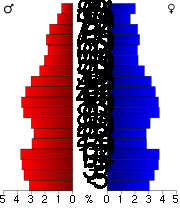
In the county the population was spread out with 24.90% under the age of 18, 8.80% from 18 to 24, 26.40% from 25 to 44, 22.40% from 45 to 64, and 17.60% who were 65 years of age or older. The median age was 38 years. For every 100 females there were 92.70 males. For every 100 females age 18 and over, there were 89.70 males.
The median income for a household in the county was $34,784, and the median income for a family was $44,133. Males had a median income of $31,171 versus $21,083 for females. The per capita income
for the county was $17,894. About 7.40% of families and 10.00% of the population were below the poverty line, including 12.00% of those under age 18 and 8.90% of those age 65 or over.
section of Illinois
is culturally isolated
from other regions in the state, and therefore is more conservative than most of the state's counties. Quincy, the county seat, holds a high number of social conservative catholic
s and likewise is the home to the campus of Quincy University
, a private
catholic liberal arts
college, and the Western Catholic Union.
In the 2008 Presidential election
, the county supported Republican
candidate John McCain
61-38% over the state's favorite son
, Barack Obama
.
:

U.S. state
A U.S. state is any one of the 50 federated states of the United States of America that share sovereignty with the federal government. Because of this shared sovereignty, an American is a citizen both of the federal entity and of his or her state of domicile. Four states use the official title of...
of Illinois
Illinois
Illinois is the fifth-most populous state of the United States of America, and is often noted for being a microcosm of the entire country. With Chicago in the northeast, small industrial cities and great agricultural productivity in central and northern Illinois, and natural resources like coal,...
. According to the 2010 census, it has a population of 67,103, which is a decrease of 1.7% from 68,277 in 2000. Its county seat
County seat
A county seat is an administrative center, or seat of government, for a county or civil parish. The term is primarily used in the United States....
is Quincy
Quincy, Illinois
Quincy, known as Illinois' "Gem City," is a river city along the Mississippi River and the county seat of Adams County. As of the 2010 census the city held a population of 40,633. The city anchors its own micropolitan area and is the economic and regional hub of West-central Illinois, catering a...
.
Adams County is part of the Quincy, IL–MO
Missouri
Missouri is a US state located in the Midwestern United States, bordered by Iowa, Illinois, Kentucky, Tennessee, Arkansas, Oklahoma, Kansas and Nebraska. With a 2010 population of 5,988,927, Missouri is the 18th most populous state in the nation and the fifth most populous in the Midwest. It...
Micropolitan Statistical Area
Quincy micropolitan area
The Quincy Micropolitan Statistical Area, as defined by the United States Census Bureau, is an area consisting of one county in western Illinois and one county in northeast Missouri, anchored by the city of Quincy....
.
Geography
According to the 2010 census, the county has a total area of 871.34 square miles (2,256.8 km²), of which 855.2 square miles (2,215 km²) (or 98.15%) is land and 16.14 square miles (41.8 km²) (or 1.85%) is water.Adjacent counties
- Hancock CountyHancock County, IllinoisHancock County is a county located in the U.S. state of Illinois. According to the 2010 census, it has a population of 19,104, which is a decrease of 5.1% from 20,121 in 2000. Its county seat is Carthage. Hamilton is the largest city in Hancock County, with Carthage being the second largest...
- north - Brown County - east
- Schuyler County - east
- Pike CountyPike County, IllinoisPike County is a county located in the U.S. state of Illinois. According to the 2010 census, it has a population of 16,430, which is a decrease of 5.5% from 17,384 in 2000...
- south - Marion County, Missouri - west
- Lewis County, Missouri - west
Major highways
-
 Interstate 172Interstate 172Interstate 172 is a spur route from Interstate 72. The highway runs north from its start outside of Hannibal, Missouri to just two miles west of Fowler, Illinois. At U.S. Highway 24, Interstate 172 becomes Illinois Route 336, which runs north to Carthage, Illinois...
 -
 US Route 24
 -
 US Route 36
 -
 Illinois Route 57Illinois Route 57Illinois Route 57 is a north–south state highway in western Illinois. It runs from Interstate 172 in Fall Creek to U.S. Route 24 and Illinois Route 104 in Quincy, a distance of .- Route description :...
 -
 Illinois Route 61Illinois Route 61Illinois Route 61 is a rural state road in western Illinois that runs north and east from Illinois Route 96 in Ursa to the intersection of U.S. Route 136 west of Tennessee. Illinois route 61 is long.-Route description:...
 -
 Illinois Route 94Illinois Route 94Illinois Route 94 is a north–south state highway in western Illinois. It runs from U.S. Route 24 just east of Camp Point to U.S. Route 67 just south of Oak Grove, just south of the Quad Cities area...
 -
 Illinois Route 96Illinois Route 96Illinois Route 96 is a north–south state road in far western Illinois. It runs from Illinois Route 100 in Kampsville, not far from a ferry crossing across the Illinois River, to Illinois Route 94 north of Terre Haute. This is a distance of ....
 -
 Illinois Route 104Illinois Route 104Illinois Route 104 is a state highway in central and western Illinois. It extends from Illinois Route 29 near Taylorville, west over the Illinois River at Meredosia to its western terminus in downtown Quincy. This is a distance of .- Route description :...
 -
 Illinois Route 336Illinois Route 336Illinois Route 336 is a four-lane freeway/expressway combination that serves western Illinois. It is also used to refer to the name of a future project to connect the cities of Quincy and Peoria via underserved Macomb....
History
Adams County was formed in 1825 out of Pike CountyPike County, Illinois
Pike County is a county located in the U.S. state of Illinois. According to the 2010 census, it has a population of 16,430, which is a decrease of 5.5% from 17,384 in 2000...
. Its name is in honor of the sixth President of the United States
President of the United States
The President of the United States of America is the head of state and head of government of the United States. The president leads the executive branch of the federal government and is the commander-in-chief of the United States Armed Forces....
, John Quincy Adams
John Quincy Adams
John Quincy Adams was the sixth President of the United States . He served as an American diplomat, Senator, and Congressional representative. He was a member of the Federalist, Democratic-Republican, National Republican, and later Anti-Masonic and Whig parties. Adams was the son of former...
.
Demographics
As of the census
Census
A census is the procedure of systematically acquiring and recording information about the members of a given population. It is a regularly occurring and official count of a particular population. The term is used mostly in connection with national population and housing censuses; other common...
of 2000, there were 68,277 people, 26,860 households, and 17,996 families residing in the county. The population density
Population density
Population density is a measurement of population per unit area or unit volume. It is frequently applied to living organisms, and particularly to humans...
was 80 people per square mile (31/km²). There were 29,386 housing units at an average density of 34 per square mile (13/km²). The racial makeup of the county was 95.10% White
Race (United States Census)
Race and ethnicity in the United States Census, as defined by the Federal Office of Management and Budget and the United States Census Bureau, are self-identification data items in which residents choose the race or races with which they most closely identify, and indicate whether or not they are...
, 3.07% Black
Race (United States Census)
Race and ethnicity in the United States Census, as defined by the Federal Office of Management and Budget and the United States Census Bureau, are self-identification data items in which residents choose the race or races with which they most closely identify, and indicate whether or not they are...
or African American
Race (United States Census)
Race and ethnicity in the United States Census, as defined by the Federal Office of Management and Budget and the United States Census Bureau, are self-identification data items in which residents choose the race or races with which they most closely identify, and indicate whether or not they are...
, 0.16% Native American
Race (United States Census)
Race and ethnicity in the United States Census, as defined by the Federal Office of Management and Budget and the United States Census Bureau, are self-identification data items in which residents choose the race or races with which they most closely identify, and indicate whether or not they are...
, 0.40% Asian
Race (United States Census)
Race and ethnicity in the United States Census, as defined by the Federal Office of Management and Budget and the United States Census Bureau, are self-identification data items in which residents choose the race or races with which they most closely identify, and indicate whether or not they are...
, 0.01% Pacific Islander
Race (United States Census)
Race and ethnicity in the United States Census, as defined by the Federal Office of Management and Budget and the United States Census Bureau, are self-identification data items in which residents choose the race or races with which they most closely identify, and indicate whether or not they are...
, 0.31% from other races
Race (United States Census)
Race and ethnicity in the United States Census, as defined by the Federal Office of Management and Budget and the United States Census Bureau, are self-identification data items in which residents choose the race or races with which they most closely identify, and indicate whether or not they are...
, and 0.95% from two or more races. 0.83% of the population were Hispanic
Race (United States Census)
Race and ethnicity in the United States Census, as defined by the Federal Office of Management and Budget and the United States Census Bureau, are self-identification data items in which residents choose the race or races with which they most closely identify, and indicate whether or not they are...
or Latino
Race (United States Census)
Race and ethnicity in the United States Census, as defined by the Federal Office of Management and Budget and the United States Census Bureau, are self-identification data items in which residents choose the race or races with which they most closely identify, and indicate whether or not they are...
of any race. 48.4% were of German, 14.1% American
United States
The United States of America is a federal constitutional republic comprising fifty states and a federal district...
, 8.6% Irish
Irish people
The Irish people are an ethnic group who originate in Ireland, an island in northwestern Europe. Ireland has been populated for around 9,000 years , with the Irish people's earliest ancestors recorded having legends of being descended from groups such as the Nemedians, Fomorians, Fir Bolg, Tuatha...
and 8.3% English
English people
The English are a nation and ethnic group native to England, who speak English. The English identity is of early mediaeval origin, when they were known in Old English as the Anglecynn. England is now a country of the United Kingdom, and the majority of English people in England are British Citizens...
ancestry according to Census 2000. 97.2% spoke English
English language
English is a West Germanic language that arose in the Anglo-Saxon kingdoms of England and spread into what was to become south-east Scotland under the influence of the Anglian medieval kingdom of Northumbria...
and 1.3% Spanish
Spanish language
Spanish , also known as Castilian , is a Romance language in the Ibero-Romance group that evolved from several languages and dialects in central-northern Iberia around the 9th century and gradually spread with the expansion of the Kingdom of Castile into central and southern Iberia during the...
as their first language.
There were 26,860 households out of which 31.10% had children under the age of 18 living with them, 54.20% were married couples
Marriage
Marriage is a social union or legal contract between people that creates kinship. It is an institution in which interpersonal relationships, usually intimate and sexual, are acknowledged in a variety of ways, depending on the culture or subculture in which it is found...
living together, 9.80% had a female householder with no husband present, and 33.00% were non-families. 28.50% of all households were made up of individuals and 13.20% had someone living alone who was 65 years of age or older. The average household size was 2.44 and the average family size was 3.00.
In the county the population was spread out with 24.90% under the age of 18, 8.80% from 18 to 24, 26.40% from 25 to 44, 22.40% from 45 to 64, and 17.60% who were 65 years of age or older. The median age was 38 years. For every 100 females there were 92.70 males. For every 100 females age 18 and over, there were 89.70 males.
The median income for a household in the county was $34,784, and the median income for a family was $44,133. Males had a median income of $31,171 versus $21,083 for females. The per capita income
Per capita income
Per capita income or income per person is a measure of mean income within an economic aggregate, such as a country or city. It is calculated by taking a measure of all sources of income in the aggregate and dividing it by the total population...
for the county was $17,894. About 7.40% of families and 10.00% of the population were below the poverty line, including 12.00% of those under age 18 and 8.90% of those age 65 or over.
Politics
Adams County, positioned in a primarily ruralRural
Rural areas or the country or countryside are areas that are not urbanized, though when large areas are described, country towns and smaller cities will be included. They have a low population density, and typically much of the land is devoted to agriculture...
section of Illinois
Illinois
Illinois is the fifth-most populous state of the United States of America, and is often noted for being a microcosm of the entire country. With Chicago in the northeast, small industrial cities and great agricultural productivity in central and northern Illinois, and natural resources like coal,...
is culturally isolated
Forgottonia
Forgottonia is the name given to a fourteen-county region in Western Illinois in the late 1960s and early 1970s. This geographic region forms the western bulge of Illinois that is roughly equivalent to "The Tract," the Illinois portion of the Military Tract of 1812, along and west of the Fourth...
from other regions in the state, and therefore is more conservative than most of the state's counties. Quincy, the county seat, holds a high number of social conservative catholic
Catholic
The word catholic comes from the Greek phrase , meaning "on the whole," "according to the whole" or "in general", and is a combination of the Greek words meaning "about" and meaning "whole"...
s and likewise is the home to the campus of Quincy University
Quincy University
Quincy University a private liberal arts Catholic university in the Franciscan tradition. It is located in Quincy, Illinois and currently enrolls around 1,300 students.-History:...
, a private
Private university
Private universities are universities not operated by governments, although many receive public subsidies, especially in the form of tax breaks and public student loans and grants. Depending on their location, private universities may be subject to government regulation. Private universities are...
catholic liberal arts
Liberal arts
The term liberal arts refers to those subjects which in classical antiquity were considered essential for a free citizen to study. Grammar, Rhetoric and Logic were the core liberal arts. In medieval times these subjects were extended to include mathematics, geometry, music and astronomy...
college, and the Western Catholic Union.
In the 2008 Presidential election
United States presidential election, 2008
The United States presidential election of 2008 was the 56th quadrennial presidential election. It was held on November 4, 2008. Democrat Barack Obama, then the junior United States Senator from Illinois, defeated Republican John McCain, the senior U.S. Senator from Arizona. Obama received 365...
, the county supported Republican
Republican Party (United States)
The Republican Party is one of the two major contemporary political parties in the United States, along with the Democratic Party. Founded by anti-slavery expansion activists in 1854, it is often called the GOP . The party's platform generally reflects American conservatism in the U.S...
candidate John McCain
John McCain
John Sidney McCain III is the senior United States Senator from Arizona. He was the Republican nominee for president in the 2008 United States election....
61-38% over the state's favorite son
Favorite son
A favorite son is a political term.*At the quadrennial American national political party conventions, a state delegation sometimes nominates and votes for a candidate from the state, or less often from the state's region, who is not a viable candidate...
, Barack Obama
Barack Obama
Barack Hussein Obama II is the 44th and current President of the United States. He is the first African American to hold the office. Obama previously served as a United States Senator from Illinois, from January 2005 until he resigned following his victory in the 2008 presidential election.Born in...
.
| Year | Democrat Democratic Party (United States) The Democratic Party is one of two major contemporary political parties in the United States, along with the Republican Party. The party's socially liberal and progressive platform is largely considered center-left in the U.S. political spectrum. The party has the lengthiest record of continuous... |
Republican Republican Party (United States) The Republican Party is one of the two major contemporary political parties in the United States, along with the Democratic Party. Founded by anti-slavery expansion activists in 1854, it is often called the GOP . The party's platform generally reflects American conservatism in the U.S... |
Third party |
|---|---|---|---|
| 2008 | (W)(I) Obama/Biden 38.6% 11,794 | McCain/Palin 60.6% 18,711 | |
| 2004 | (I) Kerry/Edwards 33% 10,511 | (W) G.W. Bush/Cheney 66% 20,834 | |
| 2000 | (I) Gore/Lieberman 40.5% 12,197 | (W) G.W. Bush/Cheney 57.6% 17,331 | Nader 1.2% 371 |
| 1996 | (W)(I) Clinton/Gore 39.9% 11,336 | Dole/Kemp 48.7% 13,836 | Perot 10.8% 3,069 |
| 1992 | (W)(I) Clinton/Gore 37.2% 11,748 | G. Bush/Quayle 42.8% 13,529 | Perot 19.5% 6,157 |
| 1988 | Dukakis/Bentsen 46.3% 13,768 | (W)(I) G. Bush/Quayle 53.3% 15,831 | |
| 1984 | Mondale/Ferraro 33.7% 10,336 | (W)(I) Reagan/Mondale 66.0% 20,225 | |
| 1980 | Carter/Mondale 33.2% 10,606 | (W)(I) Reagan/G. Bush 62.2% 19,842 | Anderson 3.8% 1,202 |
| 1976 | (W) Carter/Mondale 39.1% 11,926 | (I) Ford/Dole 59.7% 18,189 | |
| 1972 | McGovern/Shriver 30.3% 9,055 | (W)(I) Nixon/Agnew 69.5% 20,731 | |
| 1968 | Humphrey/Muskie 35.9% 11,521 | (W)(I) Nixon/Agnew 54.3% 17,444 | Wallace 9.7% 3,115 |
| 1964 | (W)(I) L. Johnson/Humphrey 56.7% 18,321 | Goldwater/Miller 43.3% 13,993 | |
| 1960 | (W)(I) Kennedy/L. Johnson 44.2% 14,827 | Nixon/Lodge 55.7% 18,674 |
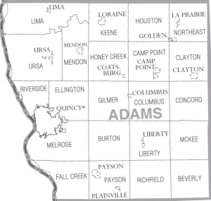
Villages
- Camp PointCamp Point, IllinoisCamp Point is a village in Adams County, Illinois, United States. The population was 1,244 at the 2000 census. It is part of the Quincy, IL–MO Micropolitan Statistical Area.Journalist and historian Allan Nevins was born in Camp Point on 20 May 1890....
- ClaytonClayton, IllinoisClayton is a village in Adams County, Illinois, United States. The population was 904 at the 2000 census. It is part of the Quincy, IL–MO Micropolitan Statistical Area.-Geography:Clayton is located at ....
- CoatsburgCoatsburg, IllinoisCoatsburg is a village in Adams County, Illinois, United States. The population was 226 at the 2000 census. It is part of the Quincy, IL–MO Micropolitan Statistical Area.-Geography:Coatsburg is located at ....
- ColumbusColumbus, IllinoisColumbus is a village in Adams County, Illinois, United States. The population was 112 at the 2000 census. It is part of the Quincy, IL–MO Micropolitan Statistical Area.-Geography:Columbus is located at ....
- GoldenGolden, IllinoisGolden is a village in Adams County, Illinois, United States. The population was 629 at the 2000 census. It is part of the Quincy, IL–MO Micropolitan Statistical Area.-Geography:Golden is located at ....
- La PrairieLa Prairie, IllinoisLa Prairie is an incorporated town in Adams County, Illinois, United States. The population was 60 at the 2000 census. It is part of the Quincy, IL–MO Micropolitan Statistical Area.-Geography:La Prairie is located at ....
- LibertyLiberty, IllinoisLiberty is a village in Adams County, Illinois, United States. The population was 519 at the 2000 census. It is part of the Quincy, IL–MO Micropolitan Statistical Area.-Geography:Liberty is located at ....
- LimaLima, IllinoisLima is a village in Adams County, Illinois, United States. The population was 159 at the 2000 census. It is part of the Quincy, IL–MO Micropolitan Statistical Area...
- LoraineLoraine, IllinoisLoraine is a village in Adams County, Illinois, United States. The population was 363 at the 2000 census. It is part of the Quincy, IL–MO Micropolitan Statistical Area.-Geography:Loraine is located at ....
- MendonMendon, IllinoisMendon is a village in Adams County, Illinois, United States. The population was 883 at the 2000 census. It is part of the Quincy, IL–MO Micropolitan Statistical Area.-Geography:Mendon is located at ....
- PaysonPayson, IllinoisPayson is a village in Adams County, Illinois, United States. The population was 1,066 at the 2000 census. It is part of the Quincy, IL–MO Micropolitan Statistical Area....
- PlainvillePlainville, IllinoisPlainville is a village in Adams County, Illinois, United States. The population was 248 at the 2000 census. It is part of the Quincy, IL–MO Micropolitan Statistical Area....
- UrsaUrsa, IllinoisUrsa is a village in Adams County, Illinois, United States. The population was 595 at the 2000 census. It is part of the Quincy, IL–MO Micropolitan Statistical Area.-Geography:Ursa is located at ....
Unincorporated
- BeverlyBeverly, IllinoisBeverly is an unincorporated community in Beverly Township, Adams County, Illinois, United States. Beverly is about southeast of Quincy....
- BigneckBigneck, IllinoisBigneck, also known as Big Neck, is an unincorporated community in Keene Township, Adams County, Illinois, United States. Bigneck is located west-northwest of Golden. The community is served by Illinois Route 61. Bigneck once had a post office which is now defunct....
- BurtonBurton, IllinoisBurton, Illinois is a village in Adams County about 4 miles east of Quincy. Burton was named English Prairie and Benton before finally being changed to its current name. -External links:*...
- Fall CreekFall Creek, IllinoisFall Creek is an unincorporated community in Fall Creek Township, Adams County, Illinois, United States. Fall Creek is located along Interstate 172 southwest of Payson....
- FowlerFowler, IllinoisFowler is an unincorporated community in Gilmer Township, Adams County, Illinois, USA, and is located near Quincy. It is part of the Quincy, IL–MO Micropolitan Statistical Area. As far as infrastructure is concerned U.S. Route 24 runs right through the center of town as well as the...
- Hickory Grove
- KellervilleKellerville, IllinoisKellerville is an unincorporated community in Clayton Township and McKee Township Townships, Adams County, Illinois, United States. Kellerville is south of Clayton and north of Siloam Springs State Park....
- KingstonKingston, Adams County, IllinoisKingston is an unincorporated community in Beverly and Richfield Townships, Adams County, Illinois, United States. Kingston is located along Illinois Route 104 southeast of Liberty....
(2 villages in Illinois share this name) - MarbleheadMarblehead, IllinoisMarblehead is an unincorporated community in Adams County, Illinois, USA, just south of Quincy. Illinois State Route 57 is the main auxiliary route through the town and travels north to the business district of Quincy or south to Interstate 72 .The community is part of the Quincy, IL–MO...
- MarcellineMarcelline, IllinoisMarcelline is an unincorporated community in Ursa Township, Adams County, Illinois, United States. Marcelline is located on Illinois Route 96 north of Ursa and south of Lima....
- MeyerMeyer, IllinoisMeyer is an unincorporated community in Adams County, Illinois, United States. It has a population of approximately 10 full time residents as of mid-2009, due to the flood of 2008. The community is part of the Quincy, IL–MO Micropolitan Statistical Area...
- North QuincyNorth Quincy, IllinoisNorth Quincy, Illinois is an unincorporated community located north of Quincy in Riverside and Ellington Townships, Adams County, Illinois; it is considered one of Quincy's largest suburbs. The town is bordered by Quincy through Koch's Lane or Locust Streets–the actual border is disputed...
- PalomaPaloma, IllinoisPaloma, Illinois is an unincorporated community in Honey Creek Township, Adams County, Illinois, United States. Its main auxiliary route is U.S. Route 24 and is within two miles of Coatsburg, another rural community...
- RichfieldRichfield, IllinoisRichfield is an unincorporated community in Richfield Township, Adams County, Illinois, United States. Richfield is east of Payson....
Townships
Adams County is divided into twenty-three townshipsTownship (United States)
A township in the United States is a small geographic area. Townships range in size from 6 to 54 square miles , with being the norm.The term is used in three ways....
:
|
Concord Township, Adams County, Illinois Concord Township is one of twenty-two townships in Adams County, Illinois, USA. At the 2000 census, its population was 293.-Geography:According to the United States Census Bureau, Concord Township covers an area of ; of this, or 0.14 percent is water.... Ellington Township, Adams County, Illinois Ellington Township is one of twenty-two townships in Adams County, Illinois, USA. As of the 2000 census, its population was 2,911. The southwest corner of the township is now part of Quincy Township.-Geography:... Fall Creek Township, Adams County, Illinois Fall Creek Township is one of twenty-two townships in Adams County, Illinois, USA. As of the 2000 census, its population was 620.-Geography:According to the United States Census Bureau, Fall Creek Township covers an area of ; of this, or 6 percent is water.... Gilmer Township, Adams County, Illinois Gilmer Township is one of twenty-two townships in Adams County, Illinois, USA. As of the 2000 census, its population was 1,143.-Geography:According to the United States Census Bureau, Gilmer Township covers an area of ; of this, or 0.18 percent is water.... Honey Creek Township, Adams County, Illinois Honey Creek Township is one of twenty-two townships in Adams County, Illinois, USA. As of the 2000 census, its population was 738.-Geography:... |
Houston Township, Adams County, Illinois Houston Township is one of twenty-two townships in Adams County, Illinois, USA. As of the 2000 census, its population was 250.-Geography:According to the United States Census Bureau, Houston Township covers an area of ; of this, or 0.04 percent is water.... Keene Township, Adams County, Illinois Keene Township is one of twenty-two townships in Adams County, Illinois, USA. As of the 2000 census, its population was 652.-Geography:According to the United States Census Bureau, Keene Township covers an area of ; of this, or 0.14 percent is water.... Liberty Township, Adams County, Illinois Liberty Township is one of twenty-two townships in Adams County, Illinois, USA. As of the 2000 census, its population was 1,217.-Geography:According to the United States Census Bureau, Liberty Township covers an area of ; of this, or 0.05 percent is water.... Lima Township, Adams County, Illinois Lima Township is one of twenty-two townships in Adams County, Illinois, USA. As of the 2000 census, its population was 588.-Geography:According to the United States Census Bureau, Lima Township covers an area of ; of this, or 4.24 percent is water.... McKee Township, Adams County, Illinois McKee Township is one of twenty-two townships in Adams County, Illinois, USA. As of the 2000 census, its population was 193.-Geography:According to the United States Census Bureau, McKee Township covers an area of ; of this, or 0.33 percent is water.... |
Melrose Township, Adams County, Illinois Melrose Township is one of twenty-two townships in Adams County, Illinois, USA. As of the 2000 census, its population was 6,305. The north-western part of the township has been separated into Quincy Township.-Geography:... Mendon Township, Adams County, Illinois Mendon Township is one of twenty-two townships in Adams County, Illinois, USA. As of the 2000 census, its population was 1,553.-Geography:According to the United States Census Bureau, Mendon Township covers an area of ; of this, or 0.05 percent is water.... Northeast Township, Adams County, Illinois Northeast Township is one of twenty-two townships in Adams County, Illinois, USA. As of the 2000 census, its population was 949.-Geography:According to the United States Census Bureau, Northeast Township covers an area of ; of this, or 0.04 percent is water.-Cemeteries:The township contains four... Payson Township, Adams County, Illinois Payson Township is one of twenty-two townships in Adams County, Illinois, USA. As of the 2000 census, its population was 1,920.-Geography:According to the United States Census Bureau, Payson Township covers an area of .-Cemeteries:... |
Richfield Township, Adams County, Illinois Richfield Township is one of twenty-two townships in Adams County, Illinois, USA. As of the 2000 census, its population was 419.-Geography:According to the United States Census Bureau, Richfield Township covers an area of ; of this, or 0.06 percent is water.-Cemeteries:The township contains seven... Riverside Township, Adams County, Illinois Riverside Township is one of twenty-two townships in Adams County, Illinois, USA. As of the 2000 census, its population was 2,397.-Geography:... Ursa Township, Adams County, Illinois Ursa Township is one of twenty-two townships in Adams County, Illinois, USA. As of the 2000 census, its population was 1,110.-Geography:According to the United States Census Bureau, Ursa Township covers an area of ; of this, or 5.5 percent is water.... |
Attractions
- Adams County Fair http://www.adamscountyfair.com/
- Bayview BridgeBayview BridgeThe Bayview Bridge is a cable-stayed bridge bringing westbound U.S. Highway 24 over the Mississippi River. It connects the cities of West Quincy, Missouri and Quincy, Illinois. Eastbound U.S. 24 is served by the older Quincy Memorial Bridge....
- Burton Cave http://dnr.state.il.us/INPC/09/Area%204/Adams/BurtonCave/BurtonCave.htm
- Fall Creek Scenic Park
- Golden Windmill http://www.goldenwindmill.org/
- John Wood MansionJohn Wood MansionJohn Wood Mansion was built in 1835 at the behest of Illinois Governor John Wood. The Greek Revival home is located in Quincy, Illinois which is in Adams County. The mansion was constructed by John Cleaveland and endured a move from its original site in 1864 to its current location...
- Saukenauk Scout Reservation http://www.mississippivalleybsa.org/saukenauk_info.html
- Siloam Springs State ParkSiloam Springs State ParkSiloam Springs State Park is an Illinois state park on in Adams and Brown counties, Illinois, United States....
- Spirit Knob Winery http://www.spiritknob.com/
- Villa Katharine http://www.villakathrine.org/
- Wavering Park http://www.quincyparkdistrict.com/parks_fac.php?park_id=25&submit_park=View+Park
Unified school districts
- Central Community Unit School District 3Central Community Unit School District 3Central Community Unit School District 3 is a unified school district located in Camp Point, a village located in the northeastern region of Adams County, Illinois. In its entirety, Central Community Unit School District 3 is composed of Central Elementary Grade School, Central Middle School,...
- Liberty Community Unit School District 2Liberty Community Unit School District 2-Liberty, Illinois Township History:"Liberty Township began with the first settlement made on Section 28, by Daniel Lile, in the spring of 1822, and many old settlers followed about the same time. The first regular preacher was George Wolfe of the Dunkard denomination. First horse mill was built...
- Mendon Community Unit School District 4
- Payson Community Unit School District 1Payson Community Unit School District 1Payson Community Unit School District 1 is a unified school district composed of Seymour Elementary School and Payson Seymour High School , and is centrally based in Payson, Illinois, a village in Adams County; it serves Payson and the surrounding municipalities...
- Quincy Public School District 172Quincy Public School District 172' is a school district based in Quincy, the county seat of Adams County, Illinois. Composed of twelve schools, it is the largest school district in Adams County. The current superintendent of the district is Lonny Lemon....
Private schools
- Blessed Sacrament Catholic School http://www.blessedscs.org/
- Chaddock School http://www.chaddock.org/
- Quincy Christian School
- Quincy Notre Dame High SchoolQuincy Notre Dame High SchoolQuincy Notre Dame High School is a Roman Catholic co-educational high school in Quincy, Illinois in the Roman Catholic Diocese of Springfield in Illinois, serving students in grades 9-12.- History :...
- St. Dominic Catholic School http://www.stdominicquincy.org/
- St. Francis Solanus Catholic School http://www.stfrancissolanus.com/
- St. James Lutheran School http://www.stjamesqcy.org/
- St. Peter Catholic School http://www.stpeterschool.com/
Colleges and universities
- Blessing-Rieman College of Nursing
- John Wood Community CollegeJohn Wood Community CollegeJohn Wood Community College , located in Quincy, Illinois, is one of 48, two-year, open-admission colleges of the Illinois Community College System , organized under the Illinois Public Community College Act.-History:...
- Quincy UniversityQuincy UniversityQuincy University a private liberal arts Catholic university in the Franciscan tradition. It is located in Quincy, Illinois and currently enrolls around 1,300 students.-History:...
Climate and weather
In recent years, average temperatures in the county seat of Quincy have ranged from a low of 16 °F (-8.9 °C) in January to a high of 88 °F (31.1 °C) in July, although a record low of -21 °F was recorded in January 1979 and a record high of 105 °F (40.6 °C) was recorded in July 2005. Average monthly precipitation ranged from 1.36 inches (3.5 cm) in January to 4.61 inches (11.7 cm) in May.External links
- Adams County GIS Website
- Register of Historic Places
- Adams County Website
- Liberty School History
- Great River Genealogical Society
- United States Census Bureau 2007 TIGER/Line Shapefiles
- United States Board on Geographic Names (GNIS)
- United States National Atlas
The source of this article is wikipedia, the free encyclopedia. The text of this article is licensed under the GFDL.