

Miami County, Kansas
Encyclopedia
Miami County is a county located in East Central
Kansas
, in the Central
United States
. As of the 2010 census, the county population was 32,787. Its county seat
and most populous city is Paola
. Miami County is a part of the Kansas City Metropolitan Area
.
, Illinois
and Indiana
)and the designation of the area as part of the Indian Territory
. The tribes included were the Miami
and Shawnee
, and the Pottawatomie
, Piankeshaw
, Kaskaskia
, Wea
and Peoria
, which comprised the Confederated Tribes. The original Miami reservation
consisted of approximately 500000 acres (2,023.4 km²). Early white settlers during that time were primarily serving as missionaries to the tribes. Over time, other settlers
continued to arrive to build homes on the Miami reservation, and by 1854, the U.S. Government purchased all but 72000 acres (291.4 km²) from the Miami tribe.
Two notable members of the Confederated Tribes were Christmas Dagnette, and Baptiste Peoria. Dagnette was born in 1800, and was a nephew of a Wea chief, originally from Indiana. He had received some formal education, spoke several of the native American languages, and additionally spoke English, French and Spanish. He had served as an interpreter to the U.S. Government by the age of sixteen. Having moved to the area that is now Miami County with the Wea tribe, he served as chief for several years before his death in 1848. Baptiste Peoria was also born around 1800, and while he didn't receive formal education like Dagnette, he learned the languages of the Shawnee, Delaware, Pottawatomie, and several more of the Confederated Tribes. In addition, he spoke English and French. Peoria was of both French and native American Indian ethnicity, and like Dagnette, served as an interpreter and as a chief for some time. Baptiste Peoria became a respected member of the Paola Town Company, and was instrumental in the founding and development of the city of Paola in the early and mid 1860's. He moved (to what is now Oklahoma) with his tribe in 1868, when they were once again removed to a newly designated Indian territory, and died there in 1878. Some of the native American Indians stayed in the area (Miami County), and became citizens of the United States.
was incorporated in 1854 due to the Kansas-Nebraska Act
,the Missouri Compromise
of 1820 was essentially repealed. Bordering the slave state of Missouri
to its east, the county (Miami) and surrounding areas became a location for violence between abolitionists and the "Border Ruffians" of Missouri. These acts of violence and battles that took place primarily from 1854–1858, became known as border wars, and Kansas became known as Bleeding Kansas
. Kansas Territory was not yet a state, and it was a battle on which forces would become dominant, slave or free. Many abolitionists came from other states to live in the area and ensure Kansas' entry as a state as a free, or anti-slavery one. The county's most notable abolitionist was John Brown
, who moved to Osawatomie,making it the headquarters for he and his anti-slavery forces. As a result of this, Osawatomie, as well as the surrounding countryside and communities became the center for several battles and acts of violence during this period.
Other lakes in Miami County, each with specific restrictions and activities to offer, include:

, county until the Kansas Constitution was amended in 1986 and voters approved the sale of alcoholic liquor by the individual drink with a 30% food sales requirement.
 As of the U.S. Census in 2000
, there were 28,351 people, 10,365 households, and 7,794 families residing in the county. The population density
was 49 people per square mile (19/km²). There were 10,984 housing units at an average density of 19 per square mile (7/km²). The racial makeup
of the county was 95.96% White
, 1.54% Black or African American
, 0.52% Native American
, 0.17% Asian
, 0.01% Pacific Islander
, 0.44% from other races, and 1.36% from two or more races
. Hispanic
or Latino
of any race were 1.59% of the population.
There were 10,365 household
s out of which 37.00% had children under the age of 18 living with them, 63.50% were married couples
living together, 8.00% had a female householder with no husband present, and 24.80% were non-families. 21.00% of all households were made up of individuals and 8.80% had someone living alone who was 65 years of age or older. The average household size was 2.66 and the average family size was 3.09.
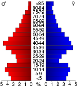
In the county the population was spread out with 27.90% under the age of 18, 7.30% from 18 to 24, 29.70% from 25 to 44, 23.10% from 45 to 64, and 11.90% who were 65 years of age or older. The median age was 37 years. For every 100 females there were 97.80 males. For every 100 females age 18 and over, there were 96.00 males.
The median income for a household
in the county was $46,665, and the median income for a family was $55,830. Males had a median income of $37,441 versus $27,271 for females. The per capita income
for the county was $21,408. About 3.60% of families and 5.50% of the population were below the poverty line, including 5.40% of those under age 18 and 8.40% of those age 65 or over.
. The cities of Louisburg
, Osawatomie
, Paola
, and Spring Hill
are considered governmentally independent and are excluded from the census figures for the townships. In the following table, the population center is the largest city (or cities) included in that township's population total, if it is of a significant size.
Additional information
Maps
East-Central Kansas
East-Central Kansas is a region of Kansas. Extending roughly from Osage County, Franklin County, and Miami County in the north to Coffey County, Anderson County and Linn County in the south. The eastern border is Missouri. The region then extends westward towards the Flint Hills to Lyon County...
Kansas
Kansas
Kansas is a US state located in the Midwestern United States. It is named after the Kansas River which flows through it, which in turn was named after the Kansa Native American tribe, which inhabited the area. The tribe's name is often said to mean "people of the wind" or "people of the south...
, in the Central
Central United States
The Central United States is sometimes conceived as between the Eastern United States and Western United States as part of a three-region model, roughly coincident with the Midwestern United States plus the western and central portions of the Southern United States; the term is also sometimes used...
United States
United States
The United States of America is a federal constitutional republic comprising fifty states and a federal district...
. As of the 2010 census, the county population was 32,787. Its county seat
County seat
A county seat is an administrative center, or seat of government, for a county or civil parish. The term is primarily used in the United States....
and most populous city is Paola
Paola, Kansas
Paola is a city in and the county seat of Miami County, Kansas, United States. As of the 2010 census, the city population was 5,602.-History:...
. Miami County is a part of the Kansas City Metropolitan Area
Kansas City Metropolitan Area
The Kansas City Metropolitan Area is a fifteen-county metropolitan area that is anchored by Kansas City, Missouri and is bisected by the border between the states of Missouri and Kansas. As of the 2010 Census, the metropolitan area has a population of 2,035,334. The metropolitan area is the...
.
Native Americans
The first settlements of the area were by native American Indian tribes, primarily in the 1820s through the 1840s. This was due to their removal from areas east (OhioOhio
Ohio is a Midwestern state in the United States. The 34th largest state by area in the U.S.,it is the 7th‑most populous with over 11.5 million residents, containing several major American cities and seven metropolitan areas with populations of 500,000 or more.The state's capital is Columbus...
, Illinois
Illinois
Illinois is the fifth-most populous state of the United States of America, and is often noted for being a microcosm of the entire country. With Chicago in the northeast, small industrial cities and great agricultural productivity in central and northern Illinois, and natural resources like coal,...
and Indiana
Indiana
Indiana is a US state, admitted to the United States as the 19th on December 11, 1816. It is located in the Midwestern United States and Great Lakes Region. With 6,483,802 residents, the state is ranked 15th in population and 16th in population density. Indiana is ranked 38th in land area and is...
)and the designation of the area as part of the Indian Territory
Indian Territory
The Indian Territory, also known as the Indian Territories and the Indian Country, was land set aside within the United States for the settlement of American Indians...
. The tribes included were the Miami
Miami tribe
The Miami are a Native American nation originally found in what is now Indiana, southwest Michigan, and western Ohio. The Miami Tribe of Oklahoma is the only federally recognized tribe of Miami Indians in the United States...
and Shawnee
Shawnee
The Shawnee, Shaawanwaki, Shaawanooki and Shaawanowi lenaweeki, are an Algonquian-speaking people native to North America. Historically they inhabited the areas of Ohio, Virginia, West Virginia, Western Maryland, Kentucky, Indiana, and Pennsylvania...
, and the Pottawatomie
Potawatomi
The Potawatomi are a Native American people of the upper Mississippi River region. They traditionally speak the Potawatomi language, a member of the Algonquian family. In the Potawatomi language, they generally call themselves Bodéwadmi, a name that means "keepers of the fire" and that was applied...
, Piankeshaw
Piankeshaw
The Piankeshaw Indians were Native Americans, and members of the Miami Indians who lived apart from the rest of the Miami nation. They lived in an area that now includes western Indiana and Ohio, and were closely allied with the Wea Indians...
, Kaskaskia
Kaskaskia
The Kaskaskia were one of about a dozen cognate tribes that made up the Illiniwek Confederation or Illinois Confederation. Their longstanding homeland was in the Great Lakes region...
, Wea
Wea
The Wea were a Miami-Illinois-speaking tribe originally located in western Indiana, closely related to the Miami. The name Wea is used today as the a shortened version of their many recorded names...
and Peoria
Peoria (tribe)
The Peoria people are a Native American tribe. Today they are enrolled in the federally recognized Peoria Tribe of Indians of Oklahoma. Historically, they were part of the Illinois Confederation.-History:...
, which comprised the Confederated Tribes. The original Miami reservation
Indian reservation
An American Indian reservation is an area of land managed by a Native American tribe under the United States Department of the Interior's Bureau of Indian Affairs...
consisted of approximately 500000 acres (2,023.4 km²). Early white settlers during that time were primarily serving as missionaries to the tribes. Over time, other settlers
American pioneer
American pioneers are any of the people in American history who migrated west to join in settling and developing new areas. The term especially refers to those who were going to settle any territory which had previously not been settled or developed by European or American society, although the...
continued to arrive to build homes on the Miami reservation, and by 1854, the U.S. Government purchased all but 72000 acres (291.4 km²) from the Miami tribe.
Two notable members of the Confederated Tribes were Christmas Dagnette, and Baptiste Peoria. Dagnette was born in 1800, and was a nephew of a Wea chief, originally from Indiana. He had received some formal education, spoke several of the native American languages, and additionally spoke English, French and Spanish. He had served as an interpreter to the U.S. Government by the age of sixteen. Having moved to the area that is now Miami County with the Wea tribe, he served as chief for several years before his death in 1848. Baptiste Peoria was also born around 1800, and while he didn't receive formal education like Dagnette, he learned the languages of the Shawnee, Delaware, Pottawatomie, and several more of the Confederated Tribes. In addition, he spoke English and French. Peoria was of both French and native American Indian ethnicity, and like Dagnette, served as an interpreter and as a chief for some time. Baptiste Peoria became a respected member of the Paola Town Company, and was instrumental in the founding and development of the city of Paola in the early and mid 1860's. He moved (to what is now Oklahoma) with his tribe in 1868, when they were once again removed to a newly designated Indian territory, and died there in 1878. Some of the native American Indians stayed in the area (Miami County), and became citizens of the United States.
Pre-Civil War Period
When Kansas TerritoryKansas Territory
The Territory of Kansas was an organized incorporated territory of the United States that existed from May 30, 1854, until January 29, 1861, when the eastern portion of the territory was admitted to the Union as the State of Kansas....
was incorporated in 1854 due to the Kansas-Nebraska Act
Kansas-Nebraska Act
The Kansas–Nebraska Act of 1854 created the territories of Kansas and Nebraska, opening new lands for settlement, and had the effect of repealing the Missouri Compromise of 1820 by allowing settlers in those territories to determine through Popular Sovereignty if they would allow slavery within...
,the Missouri Compromise
Missouri Compromise
The Missouri Compromise was an agreement passed in 1820 between the pro-slavery and anti-slavery factions in the United States Congress, involving primarily the regulation of slavery in the western territories. It prohibited slavery in the former Louisiana Territory north of the parallel 36°30'...
of 1820 was essentially repealed. Bordering the slave state of Missouri
Missouri
Missouri is a US state located in the Midwestern United States, bordered by Iowa, Illinois, Kentucky, Tennessee, Arkansas, Oklahoma, Kansas and Nebraska. With a 2010 population of 5,988,927, Missouri is the 18th most populous state in the nation and the fifth most populous in the Midwest. It...
to its east, the county (Miami) and surrounding areas became a location for violence between abolitionists and the "Border Ruffians" of Missouri. These acts of violence and battles that took place primarily from 1854–1858, became known as border wars, and Kansas became known as Bleeding Kansas
Bleeding Kansas
Bleeding Kansas, Bloody Kansas or the Border War, was a series of violent events, involving anti-slavery Free-Staters and pro-slavery "Border Ruffian" elements, that took place in the Kansas Territory and the western frontier towns of the U.S. state of Missouri roughly between 1854 and 1858...
. Kansas Territory was not yet a state, and it was a battle on which forces would become dominant, slave or free. Many abolitionists came from other states to live in the area and ensure Kansas' entry as a state as a free, or anti-slavery one. The county's most notable abolitionist was John Brown
John Brown (abolitionist)
John Brown was an American revolutionary abolitionist, who in the 1850s advocated and practiced armed insurrection as a means to abolish slavery in the United States. He led the Pottawatomie Massacre during which five men were killed, in 1856 in Bleeding Kansas, and made his name in the...
, who moved to Osawatomie,making it the headquarters for he and his anti-slavery forces. As a result of this, Osawatomie, as well as the surrounding countryside and communities became the center for several battles and acts of violence during this period.
Etymology
The county was originally established in 1855 as Lykins County, after Dr. David Lykins. Lykins was a Baptist missionary to the Native American Indian tribes in the area, and had built a school for them in what is now rural Miami County. He also served as a member of the territorial council, and was pro-slavery. By January 1861, the anti-slavery forces had been established as dominant, and Kansas entered the union as a free state. As a result of Dr. Lykins' views on slavery, Lykins County's name was changed to Miami County on June 3, 1861. The new name was in honor of the predominant Native American tribe that settled the area, the Miami.Natural gas
In 1882, a large deposit of natural gas was discovered in rural Miami County, 7 miles (11.3 km) east of Paola. By 1886 a pipeline was completed to the town's square, where it illuminated lamps there. By 1887, Paola had its street lamps lighted with lamps using natural gas. Other fields of natural gas were discovered throughout Miami County by 1887, and for a time, the area around Paola was considered to be a gas belt. In the summer of 1887, a Natural Gas Jubilee was held, which was a celebration for people to come and marvel at the use of natural gas.Community
The location of Miami County, a short drive south of Kansas City,allows it to offer residents and visitors aspects of both city and rural lifestyles. Miami County and its cities, Paola, Louisburg, Spring Hill, Osawatomie, and Fontana offer a variety of activities and hobbies. Among them are golf, hiking, camping, fishing, hunting, horseback riding, water sports, astronomy and a variety of community festivals and events that take place throughout the year. There are also historical places and museums to study its history.Miami County Farm Tour
In the spring of each year, various Miami County farms and farm businesses participate in the Miami County Farm Tour. The public is invited to come to each farm with their families as part of a free self-guided driving tour. The goal is to experience and learn about the operations, produce and/or animals at each farm stop. Visitors, and residents from Miami County, have made the farm tour an annual event.Lakes
- Hillsdale LakeHillsdale LakeHillsdale Lake is a reservoir located in the northwestern part of Miami County, in northeast Kansas and the central United States of America; it is approximately from Kansas City. The surface area of the lake is approximately , and the lake has a maximum depth of approximately .-External...
- The largest lake in Miami County, this lake is also diverse in what it offers. Among the activities at Hillsdale are camping, fishing, swimming, boating, hunting, and hiking. Hoseback riding is also largely available, with 32 miles (51.5 km) of marked trails on the lake's east side. Model airplane flying also has its own special designated area.
- Louisburg Middle Creek Lake - It is located 7 miles south of Louisburg, KansasLouisburg, KansasLouisburg is a city in Miami County, Kansas, United States. As of the 2010 census, the city population was 4,315.-19th century:Prior to the American Civil War, the land of what is now called Louisburg was part of that reserved for members of various tribes of Native Americans that were ceding...
on Metcalf road. It is a prime source of water for the city of Louisburg. In addition the lake offers superb fishing and camping. Fishing boats are allowed on the lake but swimming and water sports are prohibited. The lake is managed by the Kansas Department of Wildlife and ParksKansas Department of Wildlife and ParksThe Kansas Department of Wildlife and Parks is a state cabinet-level agency led by a Secretary of Wildlife and Parks appointed by the Governor of Kansas. The Office of the Secretary is located in Topeka, the state capital of Kansas...
. Species stocked in the lake include Bluegill, Channel, Flathead, Large and Smallmouth Bass, Crappie, Saugeye, Walleye, White Bass and Sunfish. The Lake and camp sites are open to the public at no charge. Great place to get away.
Other lakes in Miami County, each with specific restrictions and activities to offer, include:
- Miola Lake
- Miami County State Lake
- Osawatomie Lake
- Paola Lake
- Hunters Lake
- Wagstaff Lake
Law and government
Miami County was a prohibition, or "dry"Dry county
A dry county is a county in the United States whose government forbids the sale of alcoholic beverages. Some prohibit off-premises sale, some prohibit on-premises sale, and some prohibit both. Hundreds of dry counties exist across the United States, almost all of them in the South...
, county until the Kansas Constitution was amended in 1986 and voters approved the sale of alcoholic liquor by the individual drink with a 30% food sales requirement.
Geography
According to the 2000 census, the county has a total area of 590.15 square miles (1,528.5 km²), of which 576.72 square miles (1,493.7 km²) (or 97.72%) is land and 13.43 square miles (34.8 km²) (or 2.28%) is water.Adjacent counties
- Johnson CountyJohnson County, KansasJohnson County is a county located in northeast Kansas, in the central United States. The county is largely suburban, being part of the Kansas City metropolitan area, and containing many of its affluent southwestern suburbs. As of the 2010 census, the county population was 544,179. Its county...
(north) - Cass CountyCass County, MissouriCass County is a county located in the U.S. state of Missouri. As of 2010, the population was 99,478. Its county seat is Harrisonville. The county was organized in 1835 as "Van Buren County", renamed in 1848 after Michigan U.S...
, MissouriMissouriMissouri is a US state located in the Midwestern United States, bordered by Iowa, Illinois, Kentucky, Tennessee, Arkansas, Oklahoma, Kansas and Nebraska. With a 2010 population of 5,988,927, Missouri is the 18th most populous state in the nation and the fifth most populous in the Midwest. It...
(east) - Bates CountyBates County, MissouriBates County is a county located in the U.S. state of Missouri. As of 2000, the population is 16,653. Its county seat is Butler. The county was organized in 1833 and named after Frederick Bates, the second governor of Missouri....
, MissouriMissouriMissouri is a US state located in the Midwestern United States, bordered by Iowa, Illinois, Kentucky, Tennessee, Arkansas, Oklahoma, Kansas and Nebraska. With a 2010 population of 5,988,927, Missouri is the 18th most populous state in the nation and the fifth most populous in the Midwest. It...
(southeast) - Linn CountyLinn County, KansasLinn County is a county located in East Central Kansas, in the Central United States. As of the 2010 census, the county population was 9,656. Its county seat is Mound City, and its most populous city is Pleasanton...
(south) - Anderson CountyAnderson County, KansasAnderson County is a county located in East Central Kansas, in the Central United States. As of the 2010 census, the county population was 8,102...
(southwest) - Franklin CountyFranklin County, KansasFranklin County is a county located in East Central Kansas, in the Central United States. As of the 2010 census, the county population was 25,992. Its county seat and most populous city is Ottawa...
(west) - Douglas CountyDouglas County, KansasDouglas County is a county located in northeast Kansas, in the Central United States. As of the 2010 census, the county population was 110,826...
(northwest)
Demographics
United States Census, 2000
The Twenty-second United States Census, known as Census 2000 and conducted by the Census Bureau, determined the resident population of the United States on April 1, 2000, to be 281,421,906, an increase of 13.2% over the 248,709,873 persons enumerated during the 1990 Census...
, there were 28,351 people, 10,365 households, and 7,794 families residing in the county. The population density
Population density
Population density is a measurement of population per unit area or unit volume. It is frequently applied to living organisms, and particularly to humans...
was 49 people per square mile (19/km²). There were 10,984 housing units at an average density of 19 per square mile (7/km²). The racial makeup
Race (United States Census)
Race and ethnicity in the United States Census, as defined by the Federal Office of Management and Budget and the United States Census Bureau, are self-identification data items in which residents choose the race or races with which they most closely identify, and indicate whether or not they are...
of the county was 95.96% White
White American
White Americans are people of the United States who are considered or consider themselves White. The United States Census Bureau defines White people as those "having origins in any of the original peoples of Europe, the Middle East, or North Africa...
, 1.54% Black or African American
African American
African Americans are citizens or residents of the United States who have at least partial ancestry from any of the native populations of Sub-Saharan Africa and are the direct descendants of enslaved Africans within the boundaries of the present United States...
, 0.52% Native American
Native Americans in the United States
Native Americans in the United States are the indigenous peoples in North America within the boundaries of the present-day continental United States, parts of Alaska, and the island state of Hawaii. They are composed of numerous, distinct tribes, states, and ethnic groups, many of which survive as...
, 0.17% Asian
Asian American
Asian Americans are Americans of Asian descent. The U.S. Census Bureau definition of Asians as "Asian” refers to a person having origins in any of the original peoples of the Far East, Southeast Asia, or the Indian subcontinent, including, for example, Cambodia, China, India, Indonesia, Japan,...
, 0.01% Pacific Islander
Pacific Islander American
Pacific Islander Americans, also known as Oceanian Americans, are residents of the United States with original ancestry from Oceania. They represent the smallest racial group counted in the United States census of 2000. They numbered 874,000 people or 0.3 percent of the United States population...
, 0.44% from other races, and 1.36% from two or more races
Multiracial
The terms multiracial and mixed-race describe people whose ancestries come from multiple races. Unlike the term biracial, which often is only used to refer to having parents or grandparents of two different races, the term multiracial may encompass biracial people but can also include people with...
. Hispanic
Hispanic
Hispanic is a term that originally denoted a relationship to Hispania, which is to say the Iberian Peninsula: Andorra, Gibraltar, Portugal and Spain. During the Modern Era, Hispanic sometimes takes on a more limited meaning, particularly in the United States, where the term means a person of ...
or Latino
Latino
The demonyms Latino and Latina , are defined in English language dictionaries as:* "a person of Latin-American descent."* "A Latin American."* "A person of Hispanic, especially Latin-American, descent, often one living in the United States."...
of any race were 1.59% of the population.
There were 10,365 household
Household
The household is "the basic residential unit in which economic production, consumption, inheritance, child rearing, and shelter are organized and carried out"; [the household] "may or may not be synonymous with family"....
s out of which 37.00% had children under the age of 18 living with them, 63.50% were married couples
Marriage
Marriage is a social union or legal contract between people that creates kinship. It is an institution in which interpersonal relationships, usually intimate and sexual, are acknowledged in a variety of ways, depending on the culture or subculture in which it is found...
living together, 8.00% had a female householder with no husband present, and 24.80% were non-families. 21.00% of all households were made up of individuals and 8.80% had someone living alone who was 65 years of age or older. The average household size was 2.66 and the average family size was 3.09.
In the county the population was spread out with 27.90% under the age of 18, 7.30% from 18 to 24, 29.70% from 25 to 44, 23.10% from 45 to 64, and 11.90% who were 65 years of age or older. The median age was 37 years. For every 100 females there were 97.80 males. For every 100 females age 18 and over, there were 96.00 males.
The median income for a household
Median household income
The median household income is commonly used to generate data about geographic areas and divides households into two equal segments with the first half of households earning less than the median household income and the other half earning more...
in the county was $46,665, and the median income for a family was $55,830. Males had a median income of $37,441 versus $27,271 for females. The per capita income
Per capita income
Per capita income or income per person is a measure of mean income within an economic aggregate, such as a country or city. It is calculated by taking a measure of all sources of income in the aggregate and dividing it by the total population...
for the county was $21,408. About 3.60% of families and 5.50% of the population were below the poverty line, including 5.40% of those under age 18 and 8.40% of those age 65 or over.
Incorporated cities
Name and population (2004 estimate):- PaolaPaola, KansasPaola is a city in and the county seat of Miami County, Kansas, United States. As of the 2010 census, the city population was 5,602.-History:...
, 5,161 - OsawatomieOsawatomie, KansasOsawatomie is a city in Miami County, Kansas, United States, southwest of Kansas City. As of the 2010 census, the city population was 4,447. It derives its name from two streams nearby, the Osage and Potawatomie.-History:...
, 4,600 - Spring HillSpring Hill, KansasSpring Hill is a city in Johnson and Miami counties in the U.S. state of Kansas. As of the 2010 census, the city population was 5,437.-History:In 1856, James B. Hovey named the community after a town near Mobile, Alabama...
, 4,159, of which only about 2 km² (0.77220431718507 sq mi) is inside the county, the majority being in Johnson CountyJohnson County, KansasJohnson County is a county located in northeast Kansas, in the central United States. The county is largely suburban, being part of the Kansas City metropolitan area, and containing many of its affluent southwestern suburbs. As of the 2010 census, the county population was 544,179. Its county... - LouisburgLouisburg, KansasLouisburg is a city in Miami County, Kansas, United States. As of the 2010 census, the city population was 4,315.-19th century:Prior to the American Civil War, the land of what is now called Louisburg was part of that reserved for members of various tribes of Native Americans that were ceding...
, 2,998 - FontanaFontana, KansasFontana is a city in south central Miami County, Kansas, United States. As of the 2010 census, the city population was 224. The name Fontana comes from the French word fontaine, meaning fountain or a spring-like water source. It was given to the small city because it was known as a place with...
, 149
Townships
Miami County is divided into thirteen townshipsCivil township
A civil township is a widely used unit of local government in the United States, subordinate to, and geographic divisions of, a county. Specific responsibilities and the degree of autonomy vary based on each state. Civil townships are distinct from survey townships, but in states that have both,...
. The cities of Louisburg
Louisburg, Kansas
Louisburg is a city in Miami County, Kansas, United States. As of the 2010 census, the city population was 4,315.-19th century:Prior to the American Civil War, the land of what is now called Louisburg was part of that reserved for members of various tribes of Native Americans that were ceding...
, Osawatomie
Osawatomie, Kansas
Osawatomie is a city in Miami County, Kansas, United States, southwest of Kansas City. As of the 2010 census, the city population was 4,447. It derives its name from two streams nearby, the Osage and Potawatomie.-History:...
, Paola
Paola, Kansas
Paola is a city in and the county seat of Miami County, Kansas, United States. As of the 2010 census, the city population was 5,602.-History:...
, and Spring Hill
Spring Hill, Kansas
Spring Hill is a city in Johnson and Miami counties in the U.S. state of Kansas. As of the 2010 census, the city population was 5,437.-History:In 1856, James B. Hovey named the community after a town near Mobile, Alabama...
are considered governmentally independent and are excluded from the census figures for the townships. In the following table, the population center is the largest city (or cities) included in that township's population total, if it is of a significant size.
| Township | FIPS | Population center |
Population | Population density /km² (/sq mi) |
Land area km² (sq mi) | Water area km² (sq mi) | Water % | Geographic coordinates |
|---|---|---|---|---|---|---|---|---|
| Marysville | 45100 | 2,575 | 20 (51) | 131 (50) | 12 (5) | 8.28% | 38°40′48"N 94°51′31"W | |
| Miami | 46100 | 506 | 4 (10) | 126 (48) | 1 (0) | 0.53% | 38°27′56"N 94°44′47"W | |
| Middle Creek | 46225 | 1,649 | 11 (28) | 151 (58) | 1 (1) | 0.89% | 38°34′8"N 94°42′32"W | |
| Mound | 48700 | 705 | 8 (22) | 83 (32) | 0 (0) | 0.06% | 38°25′32"N 94°58′56"W | |
| Osage | 53175 | 649 | 6 (16) | 106 (41) | 0 (0) | 0.46% | 38°26′0"N 94°50′58"W | |
| Osawatomie | 53250 | 794 | 9 (23) | 90 (35) | 0 (0) | 0.12% | 38°29′7"N 94°58′53"W | |
| Paola | 54275 | 1,100 | 16 (40) | 71 (27) | 0 (0) | 0.65% | 38°33′48"N 94°51′44"W | |
| Richland | 59475 | 1,758 | 11 (27) | 166 (64) | 16 (6) | 8.89% | 38°40′23"N 95°0′11"W | |
| Stanton | 67925 | 925 | 9 (23) | 103 (40) | 0 (0) | 0.37% | 38°32′51"N 95°0′32"W | |
| Sugar Creek | 68825 | 449 | 4 (11) | 104 (40) | 1 (0) | 0.63% | 38°26′40"N 94°40′14"W | |
| Ten Mile | 70125 | 1,259 | 10 (27) | 121 (47) | 1 (0) | 0.51% | 38°40′12"N 94°45′41"W | |
| Valley | 72950 | 1,478 | 16 (41) | 93 (36) | 0 (0) | 0.37% | 38°30′54"N 94°52′25"W | |
| Wea | 76225 | 1,836 | 16 (41) | 117 (45) | 1 (0) | 0.43% | 38°39′39"N 94°40′49"W | |
| Sources: | ||||||||
See also
- National Register of Historic Places listings in Miami County, KansasNational Register of Historic Places listings in Miami County, KansasThis is a list of the National Register of Historic Places listings in Miami County, Kansas.This is intended to be a complete list of the properties and districts on the National Register of Historic Places in Miami County, Kansas, United States...
Further reading
- History of the State of Kansas; William G. Cutler; A.T. Andreas Publisher; 1883. (Online HTML eBook)
- Kansas : A Cyclopedia of State History, Embracing Events, Institutions, Industries, Counties, Cities, Towns, Prominent Persons, Etc; 3 Volumes; Frank W. Blackmar; Standard Publishing Co; 944 / 955 / 824 pages; 1912. (Volume1 - Download 54MB PDF eBook),(Volume2 - Download 53MB PDF eBook), (Volume3 - Download 33MB PDF eBook)
External links
Official sitesAdditional information
Maps
- 2008 Miami County Map, KDOT
- 2011 Kansas Highway Map, KDOT
- 2011 Kansas Railroad Map, KDOT
- 2005 Kansas School District Boundary Map, KSDE