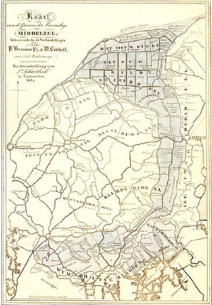
Middelzee
Encyclopedia

Estuary
An estuary is a partly enclosed coastal body of water with one or more rivers or streams flowing into it, and with a free connection to the open sea....
mouth of the River Boorn (West Frisian: Boarn) now in the Dutch
Netherlands
The Netherlands is a constituent country of the Kingdom of the Netherlands, located mainly in North-West Europe and with several islands in the Caribbean. Mainland Netherlands borders the North Sea to the north and west, Belgium to the south, and Germany to the east, and shares maritime borders...
province of Friesland
Friesland
Friesland is a province in the north of the Netherlands and part of the ancient region of Frisia.Until the end of 1996, the province bore Friesland as its official name. In 1997 this Dutch name lost its official status to the Frisian Fryslân...
. It ran from as far south as Sneek
Sneek
Sneek is a city southwest of Leeuwarden and seat of the former municipality of Sneek in the province of Friesland . As for 2011 it is part of the municipality Súdwest Fryslân...
northward to the Wadden Sea
Wadden Sea
The Wadden Sea is an intertidal zone in the southeastern part of the North Sea. It lies between the coast of northwestern continental Europe and the range of Frisian Islands, forming a shallow body of water with tidal flats and wetlands. It is rich in biological diversity...
and marked the border between main Frisian regions of Westergoa
Westergoa
Westergoa was one of the seven sealands and one of the three that now lie within the borders of today's Dutch province of Friesland. Later it was one of the three goaen of Frisia. In the Middle Ages Westergoa most probably formed the political centre of the Frisian realm.- Area :On the eastern...
and Eastergoa
Eastergoa
Eastergoa was one of the seven areas and one of the three gaue that lay within the borders of the today's Frisian province of Friesland in The Netherlands.- Area :...
. Other historical names for the Middelzee include Bordaa, Borndiep, Boerdiep, and Bordena.
Gradually the Middelzee silted up, forming the nije lannen ("new lands"). One village is called Nijlân, literally meaning "new land", and also there are several villages where the lands formerly of the Middelzee are still called it Nijlân. It can still be recognized as new land since there are only a small number of villages lying in the area of the former Middelzee. The fertile sea clay bottom is mostly used as meadow land but also Leeuwarden Air Base
Leeuwarden Air Base
Leeuwarden Air Base is a military airbase used by the Royal Netherlands Air Force - Dutch: Koninklijke Luchtmacht , . The airbase is one of the two F-16 Fighting Falcon bases of the RNLAF...
is situated on the new lands. The border between Eastergoa and Westergoa in the former Middlezee is now drained by the River Zwette (West Frisian: Swette), that runs from Sneek to Leeuwarden, but which once reached the southern edge of Het Bildt
Het Bildt
het Bildt is a municipality in the province of Friesland in the northern Netherlands; its capital is Sint Annaparochie. As of 1 November 2006 it had a population of 10,975. Het Bildt has 15.4 kilometers of coastline...
.
By the fifteenth century the Middelzee was reduced to a funnel shape along Frisia's north coast and further silting of the remaining part rendered it unusable. From the early sixteenth century the polder
Polder
A polder is a low-lying tract of land enclosed by embankments known as dikes, that forms an artificial hydrological entity, meaning it has no connection with outside water other than through manually-operated devices...
of Het Bildt
Het Bildt
het Bildt is a municipality in the province of Friesland in the northern Netherlands; its capital is Sint Annaparochie. As of 1 November 2006 it had a population of 10,975. Het Bildt has 15.4 kilometers of coastline...
was formed in that funnel, and is now a Frisian municipality that fills the mouth of what once was the Middelzee.
The name Middelzee is still used as a name for an administrative coalition between the so-called Middelzee municipalities of Het Bildt
Het Bildt
het Bildt is a municipality in the province of Friesland in the northern Netherlands; its capital is Sint Annaparochie. As of 1 November 2006 it had a population of 10,975. Het Bildt has 15.4 kilometers of coastline...
, Ferwerderadeel, Leeuwarderadeel
Leeuwarderadeel
Leeuwarderadeel is a municipality in the northern Netherlands. Its capital is Stiens.- Population centres :Bartlehiem, Britsum, Cornjum, Finkum, Hijum, Jelsum, Oude Leije, Stiens.- Bartlehiem :...
, and Menaldumadeel
Menaldumadeel
- Population centres :Population as of 1 January 2007:Beetgum , Beetgumermolen , Berlikum , Blessum , Boksum , Deinum , Dronrijp , Engelum , Kleaster-Anjum , Marssum , Menaldum , Schingen , Slappeterp , and Wier .- External links :*...
.

