
Mendip Way
Encyclopedia
The Mendip Way is an 80 kilometres (50 mi) long-distance footpath across the Mendip Hills
from Weston-super-Mare
to Frome
. It is divided into two sections.
The West Mendip Way was opened in 1979 and starts at the Bristol Channel
at Uphill Cliff
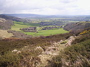
. It climbs the Mendip escarpment affording views over the Somerset Levels. It then crosses the central Mendip plateau leading down to Cheddar Gorge and on to Wells
. Most of the western section is within the Mendip Hills Area of Outstanding Natural Beauty
. From there the East Mendip Way continues through Shepton Mallet
to Frome
.
The Mendip Way connects with the Macmillan Way
, Monarch's Way
, and Samaritans Way South West. The western trailhead of the Limestone Link
is within 2 kilometres (1.2 mi) of the Mendip Way near Shipham
.
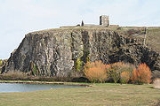
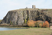 The Mendip Way starts at the village of Uphill
on the southern outskirt of Weston-super-Mare
. The route skirts Uphill Cliff
, upon which the remains of a windmill and a Norman church are located, then proceeds along the northern edge of Bleadon Level. After crossing the A370
the route skirts the village of Bleadon
and starts to ascend Bleadon Hill, where it follows a minor road for a short distance. Turning south, there is a long descent to the village of Loxton
where the M5 motorway
is crossed.
 A steep ascent then follows, nearly reaching the summit of Crook Peak (175 m (574 ft) elevation), but passing just 200 m (656 ft) to the north of it. Following the ridge from west to east, with the village of Compton Bishop
nestled in a valley to the south, the peak of Wavering Down is reached, at an elevation of 210 m (689 ft). The route here follows the northern boundary of the Crook Peak to Shute Shelve Hill SSSI
. After descending through woodland, the route crosses the Samaritans Way South West long-distance footpath which passes underneath in a tunnel of the former 'Strawberry Line' railway.
After crossing the A38
, the path ascends again, heading now in to the heart of the Mendips. After skirting to the south of Shipham
, the path passes through the plantations on Rowberrow Warren, then joins a minor road for a short distance. Just to the south is GB Cave
discovered by Francis Goddard and Charles Barker in 1939. It is one of the many caves in the Mendips
. There are also several round barrow
s in this area.
 Descending into a valley, the route swings to the southwest to Black Rock at the top of Cheddar Gorge. It continues in this direction, first climbing then descending the hill to the east of the gorge, before swinging back eastwards just short of reaching the village of Cheddar
. The path now climbs the southern escarpment of the Mendips, before descending by way of Batcombe Hollow to Draycott
.
After a short section along the A371
, the route heads back up into the hills, passing close by Draycott Sleights SSSI
and the airfield of the Mendip Gliding Club. At the top of the hill is the earthworks of an ancient settlement, and several more roundbarrows are passed on the way to Priddy
. Priddy village green has been the site of a sheep fair since 1348, and the New Inn appeared there in 1373. Heading south from Priddy, the route passes through Ebbor Gorge National Nature Reserve
, and on to Wookey Hole
, famous for its cave and witch legend. The Monarch's Way
long-distance footpath joins here, and shares some, but not all, of the same route on the way to Wells
.
The route leaves Wells by way of the path around the Bishop's Palace
moat, then enters the woods at Tor Hill, a National Trust
property, and passes by the top of a disused quarry. It then joins a track which was formerly used by horse-drawn transport to avoid paying tolls on the main road. This track passes by King's Castle wood, a reserve of the Somerset Wildlife Trust
and the site of iron age
camp. It takes the route on to the high ground of Lyatt and Furzy Sleight. Passing high above the village of Croscombe
, the path then goes through Ham Woods and turns southeast to descend towards Shepton Mallet
. Approaching town, the route roughly follows the line of the now derelict Somerset and Dorset Joint Railway
. The two large viaducts that carried the railway around the town are Grade II listed buildings.
Leaving the town behind, the path goes over Ingsdons Hill to the hamlet of Chelynch. At Waterlip the route passes by a flooded quarry, then climbs to 280 metres (919 ft), the highest point on the Mendip Way. This is the site of Cranmore Tower
, a 45 metres (148 ft) tall 19th century folly
, now a grade II listed building. Asham Wood
is a biological Site of Special Scientific Interest and the largest and most diverse of the ancient semi-natural woods in the Mendips. Further on, the hamlet of Chantry is one of the Thankful Villages
which suffered no casualties in the First World War. The path then goes alongside Whatley Quarry
which has been the subject of environmental criticism. At Forbury Bottom, the Macmillan Way shares the route for a short way until Great Elm
. The path then leads into Frome where the Mendip Way terminates.
and Frome
are served by train and coach. Buses run regularly on routes parallel to the Mendip Way, from Weston-super-Mare to Wells, and Wells to Frome. Accommodations and campsites can be found along the route. The route is covered by Ordnance Survey Explorer Maps 141, 143 and 153, and Landranger maps 182 and 183. The route is shown on recent editions of these maps.
Two publications provide more information:
Mendip Hills
The Mendip Hills is a range of limestone hills to the south of Bristol and Bath in Somerset, England. Running east to west between Weston-super-Mare and Frome, the hills overlook the Somerset Levels to the south and the Avon Valley to the north...
from Weston-super-Mare
Weston-super-Mare
Weston-super-Mare is a seaside resort, town and civil parish in the unitary authority of North Somerset, which is within the ceremonial county of Somerset, England. It is located on the Bristol Channel coast, south west of Bristol, spanning the coast between the bounding high ground of Worlebury...
to Frome
Frome
Frome is a town and civil parish in northeast Somerset, England. Located at the eastern end of the Mendip Hills, the town is built on uneven high ground, and centres around the River Frome. The town is approximately south of Bath, east of the county town, Taunton and west of London. In the 2001...
. It is divided into two sections.
The West Mendip Way was opened in 1979 and starts at the Bristol Channel
Bristol Channel
The Bristol Channel is a major inlet in the island of Great Britain, separating South Wales from Devon and Somerset in South West England. It extends from the lower estuary of the River Severn to the North Atlantic Ocean...
at Uphill Cliff
Uphill Cliff
Uphill Cliff is a 19.8 hectare biological Site of Special Scientific Interest near the village of Uphill, North Somerset, although it is in the Avon Area of Search used by English Nature which is based on the 1974-1996 county system....
. It climbs the Mendip escarpment affording views over the Somerset Levels. It then crosses the central Mendip plateau leading down to Cheddar Gorge and on to Wells
Wells
Wells is a cathedral city and civil parish in the Mendip district of Somerset, England, on the southern edge of the Mendip Hills. Although the population recorded in the 2001 census is 10,406, it has had city status since 1205...
. Most of the western section is within the Mendip Hills Area of Outstanding Natural Beauty
Area of Outstanding Natural Beauty
An Area of Outstanding Natural Beauty is an area of countryside considered to have significant landscape value in England, Wales or Northern Ireland, that has been specially designated by the Countryside Agency on behalf of the United Kingdom government; the Countryside Council for Wales on...
. From there the East Mendip Way continues through Shepton Mallet
Shepton Mallet
Shepton Mallet is a small rural town and civil parish in the Mendip district of Somerset in South West England. Situated approximately south of Bristol and east of Wells, the town is estimated to have a population of 9,700. It contains the administrative headquarters of Mendip District Council...
to Frome
Frome
Frome is a town and civil parish in northeast Somerset, England. Located at the eastern end of the Mendip Hills, the town is built on uneven high ground, and centres around the River Frome. The town is approximately south of Bath, east of the county town, Taunton and west of London. In the 2001...
.
The Mendip Way connects with the Macmillan Way
Macmillan Ways
The Macmillan Ways are a network of long-distance footpaths in England that link points on the Bristol Channel, English Channel and North Sea. They are promoted to raise money for Macmillan Cancer Relief, a charity.The Macmillan Ways are:...
, Monarch's Way
Monarch's Way
The Monarch's Way is a long-distance footpath in England that approximates the escape route taken by King Charles II in 1651 after being defeated in the Battle of Worcester.Most of the footpath is waymarked...
, and Samaritans Way South West. The western trailhead of the Limestone Link
Limestone Link
The Limestone Link is a long-distance footpath from the Mendip Hills in Somerset to Cold Ashton in Gloucestershire. It is marked by an Ammonite waymarker....
is within 2 kilometres (1.2 mi) of the Mendip Way near Shipham
Shipham
Shipham is a village and civil parish in Somerset, England on the western edge of the Mendip Hills near the A38, approximately south of Bristol. It is in the local government district of Sedgemoor. The parish includes the village of Rowberrow and the hamlet of Star...
.
Route description
Uphill
Uphill is a village on the edge of Weston-super-Mare in North Somerset, England.-History:There is evidence of a port at Uphill since Roman times, probably for the export of lead from the Mendip Hills...
on the southern outskirt of Weston-super-Mare
Weston-super-Mare
Weston-super-Mare is a seaside resort, town and civil parish in the unitary authority of North Somerset, which is within the ceremonial county of Somerset, England. It is located on the Bristol Channel coast, south west of Bristol, spanning the coast between the bounding high ground of Worlebury...
. The route skirts Uphill Cliff
Uphill Cliff
Uphill Cliff is a 19.8 hectare biological Site of Special Scientific Interest near the village of Uphill, North Somerset, although it is in the Avon Area of Search used by English Nature which is based on the 1974-1996 county system....
, upon which the remains of a windmill and a Norman church are located, then proceeds along the northern edge of Bleadon Level. After crossing the A370
A370 road
The A370 is a primary road in England running from Bristol to Weston-super-Mare and on to East Brent in Somerset. A more direct route from Bristol to East Brent is the A38.-Route:...
the route skirts the village of Bleadon
Bleadon
Bleadon is a village and civil parish in the historic countyof Somerset, England. It is about south of Weston-super-Mare and, according to the 2001 census, has a population of 1,068.-History:...
and starts to ascend Bleadon Hill, where it follows a minor road for a short distance. Turning south, there is a long descent to the village of Loxton
Loxton, North Somerset
Loxton is a village and civil parish in Somerset, England. It is close to the M5 motorway in the Unitary Authority of North Somerset. The parish includes the village of Christon and has a population of 202.-History:...
where the M5 motorway
M5 motorway
The M5 is a motorway in England. It runs from a junction with the M6 at West Bromwich near Birmingham to Exeter in Devon. Heading south-west, the M5 runs east of West Bromwich and west of Birmingham through Sandwell Valley...
is crossed.
Compton Bishop
Compton Bishop is a small village and civil parish, at the western end of the Mendip Hills in the English county of Somerset. It is located close to the historic town of Axbridge...
nestled in a valley to the south, the peak of Wavering Down is reached, at an elevation of 210 m (689 ft). The route here follows the northern boundary of the Crook Peak to Shute Shelve Hill SSSI
Crook Peak to Shute Shelve Hill
Crook Peak to Shute Shelve Hill to is a 332.2 hectare geological and biological Site of Special Scientific Interest near the western end of the Mendip Hills, Somerset, notified in 1952.-The site:...
. After descending through woodland, the route crosses the Samaritans Way South West long-distance footpath which passes underneath in a tunnel of the former 'Strawberry Line' railway.
After crossing the A38
A38 road
The A38, part of which is also known as the Devon Expressway, is a major A-class trunk road in England.The road runs from Bodmin in Cornwall to Mansfield in Nottinghamshire. It is long, making it one of the longest A-roads in England. It was formerly known as the Leeds — Exeter Trunk Road,...
, the path ascends again, heading now in to the heart of the Mendips. After skirting to the south of Shipham
Shipham
Shipham is a village and civil parish in Somerset, England on the western edge of the Mendip Hills near the A38, approximately south of Bristol. It is in the local government district of Sedgemoor. The parish includes the village of Rowberrow and the hamlet of Star...
, the path passes through the plantations on Rowberrow Warren, then joins a minor road for a short distance. Just to the south is GB Cave
GB Cave
GB Cave is a cave between Charterhouse and Shipham in the limestone of the Mendip Hills, in Somerset, England, and is close to Charterhouse Cave, the deepest in the region....
discovered by Francis Goddard and Charles Barker in 1939. It is one of the many caves in the Mendips
Caves of the Mendip Hills
The Caves of the Mendip Hills are formed by the particular geology of the Mendip Hills, with large areas of limestone worn away by water makes it a national centre for caving. The hills conceal the largest underground river system in Britain.- Geology :...
. There are also several round barrow
Round barrow
Round barrows are one of the most common types of archaeological monuments. Although concentrated in Europe they are found in many parts of the world because of their simple construction and universal purpose....
s in this area.
Cheddar
Cheddar is a large village and civil parish in the Sedgemoor district of the English county of Somerset. It is situated on the southern edge of the Mendip Hills, north-west of Wells. The civil parish includes the hamlets of Nyland and Bradley Cross...
. The path now climbs the southern escarpment of the Mendips, before descending by way of Batcombe Hollow to Draycott
Draycott, Somerset
Draycott is a small village in Somerset, England, neighbouring the village of Cheddar on the southern edge of the Mendip Hills Area of Outstanding Natural Beauty...
.
After a short section along the A371
A371 road
The A371 is a primary road in England running from Wincanton in Somerset, to Weston-super-Mare in North Somerset.The A371 starts at the A303, then passes Castle Cary, Ansford, Cannard's Grave , Shepton Mallet, Croscombe, Wells, Easton, Somerset, Westbury-sub-Mendip, Rodney Stoke, Draycott, Cheddar,...
, the route heads back up into the hills, passing close by Draycott Sleights SSSI
Draycott Sleights
Draycott Sleights is a biological Site of Special Scientific Interest at Draycott in the Mendip Hills, Somerset, notified in 1987.The Somerset Wildlife Trust reserve lies south east of Cheddar. It includes Draycott Sleights, , and Draycott Housegrounds,...
and the airfield of the Mendip Gliding Club. At the top of the hill is the earthworks of an ancient settlement, and several more roundbarrows are passed on the way to Priddy
Priddy
Priddy is a village in Somerset, England in the Mendip Hills, close to East Harptree and north-west of Wells. It is in the local government district of Mendip....
. Priddy village green has been the site of a sheep fair since 1348, and the New Inn appeared there in 1373. Heading south from Priddy, the route passes through Ebbor Gorge National Nature Reserve
Ebbor Gorge
Ebbor Gorge is a limestone gorge in Somerset, England, close to Wells, designated as a biological Site of Special Scientific Interest in the Mendip Hills, notified in 1952....
, and on to Wookey Hole
Wookey Hole
Wookey Hole Caves is a show cave and tourist attraction in the village of Wookey Hole on the southern edge of the Mendip Hills near Wells in Somerset, England.Wookey Hole cave was formed through erosion of the limestone hills by the River Axe...
, famous for its cave and witch legend. The Monarch's Way
Monarch's Way
The Monarch's Way is a long-distance footpath in England that approximates the escape route taken by King Charles II in 1651 after being defeated in the Battle of Worcester.Most of the footpath is waymarked...
long-distance footpath joins here, and shares some, but not all, of the same route on the way to Wells
Wells
Wells is a cathedral city and civil parish in the Mendip district of Somerset, England, on the southern edge of the Mendip Hills. Although the population recorded in the 2001 census is 10,406, it has had city status since 1205...
.
The route leaves Wells by way of the path around the Bishop's Palace
Bishop's Palace, Wells
The Bishop's Palace, Wells, Somerset, England, is adjacent to Wells Cathedral and has been the home of the Bishops of the Diocese of Bath and Wells for 800 years....
moat, then enters the woods at Tor Hill, a National Trust
National Trust for Places of Historic Interest or Natural Beauty
The National Trust for Places of Historic Interest or Natural Beauty, usually known as the National Trust, is a conservation organisation in England, Wales and Northern Ireland...
property, and passes by the top of a disused quarry. It then joins a track which was formerly used by horse-drawn transport to avoid paying tolls on the main road. This track passes by King's Castle wood, a reserve of the Somerset Wildlife Trust
Somerset Wildlife Trust
Somerset Wildlife Trust is a wildlife trust covering the county of Somerset, England.The trust, which was established in 1964, aims to safeguard the county's wildlife and wild places for this and future generations and manages almost 80 nature reserves. Examples include Fyne Court, Westhay Moor,...
and the site of iron age
Iron Age
The Iron Age is the archaeological period generally occurring after the Bronze Age, marked by the prevalent use of iron. The early period of the age is characterized by the widespread use of iron or steel. The adoption of such material coincided with other changes in society, including differing...
camp. It takes the route on to the high ground of Lyatt and Furzy Sleight. Passing high above the village of Croscombe
Croscombe
Croscombe is a village and civil parish west of Shepton Mallet and from Wells, in the Mendip district of Somerset, England. It is situated on the A371 road in the valley of the River Sheppey....
, the path then goes through Ham Woods and turns southeast to descend towards Shepton Mallet
Shepton Mallet
Shepton Mallet is a small rural town and civil parish in the Mendip district of Somerset in South West England. Situated approximately south of Bristol and east of Wells, the town is estimated to have a population of 9,700. It contains the administrative headquarters of Mendip District Council...
. Approaching town, the route roughly follows the line of the now derelict Somerset and Dorset Joint Railway
Somerset and Dorset Joint Railway
The Somerset & Dorset Joint Railway – almost always referred to as "the S&D" – was an English railway line connecting Bath in north east Somerset and Bournemouth now in south east Dorset but then in Hampshire...
. The two large viaducts that carried the railway around the town are Grade II listed buildings.
Leaving the town behind, the path goes over Ingsdons Hill to the hamlet of Chelynch. At Waterlip the route passes by a flooded quarry, then climbs to 280 metres (919 ft), the highest point on the Mendip Way. This is the site of Cranmore Tower
Cranmore Tower
The Cranmore Tower is a tall 19th century folly in the parish of Cranmore, Somerset, England. The site is above sea level, and is the highest point on the Mendip Way....
, a 45 metres (148 ft) tall 19th century folly
Folly
In architecture, a folly is a building constructed primarily for decoration, but either suggesting by its appearance some other purpose, or merely so extravagant that it transcends the normal range of garden ornaments or other class of building to which it belongs...
, now a grade II listed building. Asham Wood
Asham Wood
Asham Wood is a biological Site of Special Scientific Interest near Downhead in the Mendip Hills, Somerset, notified in 1963.Asham Wood is the largest and most diverse of the ancient semi-natural woods in the Mendips...
is a biological Site of Special Scientific Interest and the largest and most diverse of the ancient semi-natural woods in the Mendips. Further on, the hamlet of Chantry is one of the Thankful Villages
Thankful Villages
Thankful Villages are settlements in both England and Wales from which all their then members of the armed forces survived World War I. The term Thankful Village was popularised by the writer Arthur Mee in the 1930s...
which suffered no casualties in the First World War. The path then goes alongside Whatley Quarry
Whatley Quarry
Whatley Quarry, is a limestone quarry owned by Hanson plc, near the village of Whatley on the Mendip Hills, Somerset, England.The quarry exhibits pale to dark grey Carboniferous Limestone with small area of overlying horizontally bedded buff-coloured Jurassic oolitic limestone forming an angular...
which has been the subject of environmental criticism. At Forbury Bottom, the Macmillan Way shares the route for a short way until Great Elm
Great Elm
Great Elm is a village and civil parish between Mells and Frome in the Mendip district of Somerset, England. The parish includes the hamlet of Hapsford.-History:...
. The path then leads into Frome where the Mendip Way terminates.
Services
Weston-super-MareWeston-super-Mare
Weston-super-Mare is a seaside resort, town and civil parish in the unitary authority of North Somerset, which is within the ceremonial county of Somerset, England. It is located on the Bristol Channel coast, south west of Bristol, spanning the coast between the bounding high ground of Worlebury...
and Frome
Frome
Frome is a town and civil parish in northeast Somerset, England. Located at the eastern end of the Mendip Hills, the town is built on uneven high ground, and centres around the River Frome. The town is approximately south of Bath, east of the county town, Taunton and west of London. In the 2001...
are served by train and coach. Buses run regularly on routes parallel to the Mendip Way, from Weston-super-Mare to Wells, and Wells to Frome. Accommodations and campsites can be found along the route. The route is covered by Ordnance Survey Explorer Maps 141, 143 and 153, and Landranger maps 182 and 183. The route is shown on recent editions of these maps.
Two publications provide more information:
- Uphill to Frome: a guide to the Mendip Way, by David Wright ISBN 0 9539237 0 3. A guide to the complete route, with maps.
- West Mendip Way by Andrew Eddy, Weston Heritage Centre. Detailed guide to the western section Uphill to Wells, with maps.