

Caves of the Mendip Hills
Encyclopedia
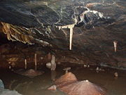
The Caves of the Mendip Hills are formed by the particular geology of the Mendip Hills
, with large areas of limestone worn away by water makes it a national centre for caving
. The hills conceal the largest underground river system in Britain.
s of Carboniferous Limestone
lying over Devonian
Old Red Sandstone
. When a surface stream running down one of the impermeable Sandstone peaks reaches the layer of Limestone it sinks below ground through a "swallet", (also known locally as a "slocker"), continuing on its way down towards sea level by enlarging existing cracks in the rock to form caves, and reappearing at the base of the limestone outcrop. As the water changes route within the hill, finding a more direct route, some caves (or parts of caves) are left dry.
 There is characteristic type of Mendip cave, in which there is an initially steep descent, and then a more level stretch ending in a "sump
" as the cave reaches and descends below the prevailing water table
. The passages below the water table (which may be accessible by cave diving) often have a loop formation caused by the water flowing down a bedding plane and then rising up a fracture in the rock. Few caves on the Mendip Hills are more than 150 metres (492 ft) deep or a few kilometres in length, (with some notable exceptions, such as Swildon's Hole
which is over 9 kilometres (6 mi) long), but a number are complex with several levels of passages which have been abandoned by the water, for example those around Cheddar
.
The catchment area of the Cheddar Yeo
, which rises in Gough's Cave
, measures 54 km² (20.8 sq mi). Dye marking shows that some of the water travels underground for up to 10 miles (16 km), taking up to 14 days to reach Cheddar
.
was discovered in 1824, it was found to contain a great many animal bones which have been dated as about 80,000 years old.
The earliest scientifically dated human cemetery in Britain
was found at Aveline's Hole
, in Burrington Combe
. The human bone fragments it contained, from about 21 different individuals, are thought to be between roughly 10,200 and 10,400 years old.
Archaeological evidence including pottery, flints, hearths, coins, burials and metalwork from the Mesolithic
, Neolithic
, Bronze Age
, Iron Age
and Roman eras have been found in many of the caves.
A number of Mendip caves were found by miners, for example the Banwell Caves which were opened by ochre
miners in 1757.
Many caves in the Mendip area were photographed by caver Harry Savory early in the 20th century using huge cameras
, glass plates
and flash powder
. His work has been described as ".. of a quality to shame virtually all modern cave photographers". The 1990 book A Man Deep in Mendip: The Caving Diaries of Harry Savory, 1910-1921 provides a diary made by Harry Savory, which is explained and extended by his son John.
, but the vast majority of the caves require specialist equipment and knowledge. Many of the caves are gated and operate leader systems in an attempt to reduce the damage caused when the caves are visited. Local caving groups organise trips and continue to discover new caverns. Some estimates put the number of cavers active on the Mendip Hills over a busy weekend at over 500.
; the first cave dive attempt in Britain took place at Swildon's Hole
in 1934. The first successful cave dive in Britain was achieved the following year at Wookey Hole
, where the last sump is currently the deepest sump in Britain at 76 m (249 ft).
, Thrupe Lane Swallet
, Lamb Leer
and Priddy Caves
have been identified as geological Site of Special Scientific Interest. There are also caves within the Cheddar Complex
SSSI.
Mendip Hills
The Mendip Hills is a range of limestone hills to the south of Bristol and Bath in Somerset, England. Running east to west between Weston-super-Mare and Frome, the hills overlook the Somerset Levels to the south and the Avon Valley to the north...
, with large areas of limestone worn away by water makes it a national centre for caving
Caving
Caving—also occasionally known as spelunking in the United States and potholing in the United Kingdom—is the recreational pastime of exploring wild cave systems...
. The hills conceal the largest underground river system in Britain.
Geology
The hills consist of anticlineAnticline
In structural geology, an anticline is a fold that is convex up and has its oldest beds at its core. The term is not to be confused with antiform, which is a purely descriptive term for any fold that is convex up. Therefore if age relationships In structural geology, an anticline is a fold that is...
s of Carboniferous Limestone
Carboniferous limestone
Carboniferous Limestone is a term used to describe a variety of different types of limestone occurring widely across Great Britain and Ireland which were deposited during the Dinantian epoch of the Carboniferous period. They were formed between 363 and 325 million years ago...
lying over Devonian
Devonian
The Devonian is a geologic period and system of the Paleozoic Era spanning from the end of the Silurian Period, about 416.0 ± 2.8 Mya , to the beginning of the Carboniferous Period, about 359.2 ± 2.5 Mya...
Old Red Sandstone
Old Red Sandstone
The Old Red Sandstone is a British rock formation of considerable importance to early paleontology. For convenience the short version of the term, 'ORS' is often used in literature on the subject.-Sedimentology:...
. When a surface stream running down one of the impermeable Sandstone peaks reaches the layer of Limestone it sinks below ground through a "swallet", (also known locally as a "slocker"), continuing on its way down towards sea level by enlarging existing cracks in the rock to form caves, and reappearing at the base of the limestone outcrop. As the water changes route within the hill, finding a more direct route, some caves (or parts of caves) are left dry.
Sump (cave)
Sump is a term used in caving to describe a submerged passage in a cave. A sump may be static, with no inward or outward flow, or active, with continuous through-flow...
" as the cave reaches and descends below the prevailing water table
Water table
The water table is the level at which the submarine pressure is far from atmospheric pressure. It may be conveniently visualized as the 'surface' of the subsurface materials that are saturated with groundwater in a given vicinity. However, saturated conditions may extend above the water table as...
. The passages below the water table (which may be accessible by cave diving) often have a loop formation caused by the water flowing down a bedding plane and then rising up a fracture in the rock. Few caves on the Mendip Hills are more than 150 metres (492 ft) deep or a few kilometres in length, (with some notable exceptions, such as Swildon's Hole
Swildon's Hole
Swildon's Hole is an extensive cave in Priddy, Somerset. At in length, it is the longest cave on the Mendip Hills. It has been found to be connected to Priddy Green Sink and forms part of the Priddy Caves Site of Special Scientific Interest ....
which is over 9 kilometres (6 mi) long), but a number are complex with several levels of passages which have been abandoned by the water, for example those around Cheddar
Cheddar
Cheddar is a large village and civil parish in the Sedgemoor district of the English county of Somerset. It is situated on the southern edge of the Mendip Hills, north-west of Wells. The civil parish includes the hamlets of Nyland and Bradley Cross...
.
The catchment area of the Cheddar Yeo
Cheddar Yeo
The Cheddar Yeo is a small river in North Somerset, England. Beneath the limestone of the Mendip Hills it forms the largest underground river system in Britain. After emerging into Cheddar Gorge it flows through the village of Cheddar, where it has been used in the past to power mills...
, which rises in Gough's Cave
Gough's Cave
Gough's Cave is located in Cheddar Gorge on the Mendip Hills, in Cheddar, Somerset, England. The cave is deep and is long,and contains a variety of large chambers and rock formations. It contains the Cheddar Yeo, the largest underground river system in Britain.- History :The initial sections of...
, measures 54 km² (20.8 sq mi). Dye marking shows that some of the water travels underground for up to 10 miles (16 km), taking up to 14 days to reach Cheddar
Cheddar
Cheddar is a large village and civil parish in the Sedgemoor district of the English county of Somerset. It is situated on the southern edge of the Mendip Hills, north-west of Wells. The civil parish includes the hamlets of Nyland and Bradley Cross...
.
History
When Banwell Bone CaveBanwell Caves
Banwell Caves are a 1.7-hectare geological and biological Site of Special Scientific Interest near the village of Banwell, North Somerset, England notified in 1963....
was discovered in 1824, it was found to contain a great many animal bones which have been dated as about 80,000 years old.
The earliest scientifically dated human cemetery in Britain
Great Britain
Great Britain or Britain is an island situated to the northwest of Continental Europe. It is the ninth largest island in the world, and the largest European island, as well as the largest of the British Isles...
was found at Aveline's Hole
Aveline's Hole
Aveline's Hole is a cave at Burrington Combe in the limestone of the Mendip Hills, in Somerset, England.The earliest scientifically dated cemetery in Britain was found at Aveline's Hole...
, in Burrington Combe
Burrington Combe
Burrington Combe is a carboniferous limestone gorge near the village of Burrington, on the north side of the Mendip Hills Area of Outstanding Natural Beauty, in North Somerset, England....
. The human bone fragments it contained, from about 21 different individuals, are thought to be between roughly 10,200 and 10,400 years old.
Archaeological evidence including pottery, flints, hearths, coins, burials and metalwork from the Mesolithic
Mesolithic
The Mesolithic is an archaeological concept used to refer to certain groups of archaeological cultures defined as falling between the Paleolithic and the Neolithic....
, Neolithic
Neolithic
The Neolithic Age, Era, or Period, or New Stone Age, was a period in the development of human technology, beginning about 9500 BC in some parts of the Middle East, and later in other parts of the world. It is traditionally considered as the last part of the Stone Age...
, Bronze Age
Bronze Age
The Bronze Age is a period characterized by the use of copper and its alloy bronze as the chief hard materials in the manufacture of some implements and weapons. Chronologically, it stands between the Stone Age and Iron Age...
, Iron Age
Iron Age
The Iron Age is the archaeological period generally occurring after the Bronze Age, marked by the prevalent use of iron. The early period of the age is characterized by the widespread use of iron or steel. The adoption of such material coincided with other changes in society, including differing...
and Roman eras have been found in many of the caves.
A number of Mendip caves were found by miners, for example the Banwell Caves which were opened by ochre
Ochre
Ochre is the term for both a golden-yellow or light yellow brown color and for a form of earth pigment which produces the color. The pigment can also be used to create a reddish tint known as "red ochre". The more rarely used terms "purple ochre" and "brown ochre" also exist for variant hues...
miners in 1757.
Many caves in the Mendip area were photographed by caver Harry Savory early in the 20th century using huge cameras
View camera
The view camera is a type of camera first developed in the era of the Daguerreotype and still in use today, though with many refinements. It comprises a flexible bellows which forms a light-tight seal between two adjustable standards, one of which holds a lens, and the other a viewfinder or a...
, glass plates
Photographic plate
Photographic plates preceded photographic film as a means of photography. A light-sensitive emulsion of silver salts was applied to a glass plate. This form of photographic material largely faded from the consumer market in the early years of the 20th century, as more convenient and less fragile...
and flash powder
Flash powder
Flash powder is a pyrotechnic composition, a mixture of oxidizer and metallic fuel, which burns quickly and if confined produces a loud report. It is widely used in theatrical pyrotechnics and fireworks and was once used for flashes in photography.Different varieties of flash powder are made from...
. His work has been described as ".. of a quality to shame virtually all modern cave photographers". The 1990 book A Man Deep in Mendip: The Caving Diaries of Harry Savory, 1910-1921 provides a diary made by Harry Savory, which is explained and extended by his son John.
Access
The caves which are easily accessible to the public are at Cheddar Gorge and Wookey HoleWookey Hole
Wookey Hole Caves is a show cave and tourist attraction in the village of Wookey Hole on the southern edge of the Mendip Hills near Wells in Somerset, England.Wookey Hole cave was formed through erosion of the limestone hills by the River Axe...
, but the vast majority of the caves require specialist equipment and knowledge. Many of the caves are gated and operate leader systems in an attempt to reduce the damage caused when the caves are visited. Local caving groups organise trips and continue to discover new caverns. Some estimates put the number of cavers active on the Mendip Hills over a busy weekend at over 500.
Cave Diving
Attempts made in the Mendip Hills to move from one cave to another through the underground rivers led to the development of cave divingCave diving
Cave diving is a type of technical diving in which specialized equipment is used to enable the exploration of caves which are at least partially filled with water. In the United Kingdom it is an extension of the more common sport of caving, and in the United States an extension of the more common...
; the first cave dive attempt in Britain took place at Swildon's Hole
Swildon's Hole
Swildon's Hole is an extensive cave in Priddy, Somerset. At in length, it is the longest cave on the Mendip Hills. It has been found to be connected to Priddy Green Sink and forms part of the Priddy Caves Site of Special Scientific Interest ....
in 1934. The first successful cave dive in Britain was achieved the following year at Wookey Hole
Wookey Hole
Wookey Hole Caves is a show cave and tourist attraction in the village of Wookey Hole on the southern edge of the Mendip Hills near Wells in Somerset, England.Wookey Hole cave was formed through erosion of the limestone hills by the River Axe...
, where the last sump is currently the deepest sump in Britain at 76 m (249 ft).
Sites of Special Scientific Interest
The cave complexes at St. Dunstan's Well CatchmentSt. Dunstan's Well Catchment
St. Dunstan's Well Catchment is a geological Site of Special Scientific Interest, covering near Stoke St Michael in the Mendip Hills, Somerset, notified in 1967.Formerly known as Stoke St Michael Slocker.- Geological :...
, Thrupe Lane Swallet
Thrupe Lane Swallet
Thrupe Lane Swallet is a 0.5 hectare geological Site of Special Scientific Interest in Somerset, notified in 1992. It is a Geological Conservation Review site.The name Thrupe Lane comes from the nearby hamlet of Thrupe, which in Anglo-Saxon meant dairy farm....
, Lamb Leer
Lamb Leer
Lamb Leer is a 14.59 hectare geological Site of Special Scientific Interest between East Harptree and Priddy in the Mendip Hills, Somerset, notified in 1983. The cavern is a fragment of a very ancient major cave system which now contains one of the largest chambers on Mendip.- History :Several...
and Priddy Caves
Priddy Caves
Priddy Caves is an Area: 67.6 hectare geological Site of Special Scientific Interest at Priddy in the Mendip Hills, Somerset, notified in 1965.The entrance to St Cuthbert's Swallet is incorporated in the adjacent Priddy Pools SSSI....
have been identified as geological Site of Special Scientific Interest. There are also caves within the Cheddar Complex
Cheddar Complex
The Cheddar Complex is a 441.3 hectare biological Site of Special Scientific Interest near Cheddar around the Cheddar Gorge and north east to Charterhouse in the Mendip Hills, Somerset, notified in 1952....
SSSI.
List of caves
A selection of the better known caves are listed below| Name | Location | Map | Length (km) | Depth (m) | Notes |
|---|---|---|---|---|---|
| Attborough Swallet Attborough Swallet Attborough Swallet is a cave in Chewton Mendip in Somerset, England. It is unusual for a cave on the Mendip Hills in that it is not in limestone but instead in Dolomitic Conglomerate and Marl. The cave was first entered in 1992.It takes its name from the Attborough field in which the entrance is... |
Chewton Mendip Chewton Mendip Chewton Mendip is a village and civil parish in the Mendip District of Somerset, England. It is situated north of Wells, south of Bristol on the Mendip Hills and is the source of the River Chew. The parish includes the hamlet of Bathway.- History :... |
0.22 | 44 | ||
| Aveline's Hole Aveline's Hole Aveline's Hole is a cave at Burrington Combe in the limestone of the Mendip Hills, in Somerset, England.The earliest scientifically dated cemetery in Britain was found at Aveline's Hole... |
Burrington Combe Burrington Combe Burrington Combe is a carboniferous limestone gorge near the village of Burrington, on the north side of the Mendip Hills Area of Outstanding Natural Beauty, in North Somerset, England.... |
0.067 | 16 | Site of early cemetery & cave markings | |
| Axbridge Ochre Mine | Axbridge Axbridge Axbridge is a town in Somerset, England, situated in the Sedgemoor district on the River Axe, near the southern edge of the Mendip Hills. The town population according to the 2001 census was 2,024.-History:... |
0.132 | 33 | ||
| Banwell Caves Banwell Caves Banwell Caves are a 1.7-hectare geological and biological Site of Special Scientific Interest near the village of Banwell, North Somerset, England notified in 1963.... |
Banwell Banwell Banwell is a village and civil parish on the River Banwell in the North Somerset district of Somerset, England. Its population was 2,923 according to the 2001 census.-History:... |
0.097 | 21 | geological Site of Special Scientific Interest | |
| Banwell Ochre Caves Banwell Ochre Caves Banwell Ochre Caves are a 12.46-hectare geological Site of Special Scientific Interest near the village of Banwell, North Somerset, notified in 1983.... |
Banwell Banwell Banwell is a village and civil parish on the River Banwell in the North Somerset district of Somerset, England. Its population was 2,923 according to the 2001 census.-History:... |
geological Site of Special Scientific Interest | |||
| Charterhouse Cave Charterhouse Cave Charterhouse Cave,on the Mendip Hills in Somerset, is the deepest cave in southern England.- History :Charterhouse Cave was first excavated in 1972... |
Charterhouse Charterhouse, Somerset Charterhouse, also known as Charterhouse-on-Mendip, is a hamlet in the Mendip Hills Area of Outstanding Natural Beauty in the English county of Somerset... |
1.7 | 205 | Close, but not connected, to GB Cave GB Cave GB Cave is a cave between Charterhouse and Shipham in the limestone of the Mendip Hills, in Somerset, England, and is close to Charterhouse Cave, the deepest in the region.... . Deepest cave on the Mendip Hills. |
|
| Compton Martin Ochre Mine Compton Martin Ochre Mine Compton Martin Ochre Mine is a 0.85 hectare geological and biological Site of Special Scientific Interest located on the north side of the Mendip Hills, immediately south west of Compton Martin village, Somerset, notified in 1988.-Geological Interest:... |
Compton Martin Compton Martin Compton Martin is a small village and civil parish within the Chew Valley in Somerset and civil parish in the Bath and North East Somerset unitary authority in England. The parish has a population of 508... |
0.4 | 21 | geological Site of Special Scientific Interest | |
| Cox's Cave Cox's cave Cox's Cave is in Cheddar Gorge on the Mendip Hills, in Somerset, England. It is open to the public as a show cave.The cave is named after mill owner George Cox who discovered it in 1837, while quarrying limestone for a new building.... |
Cheddar Cheddar Cheddar is a large village and civil parish in the Sedgemoor district of the English county of Somerset. It is situated on the southern edge of the Mendip Hills, north-west of Wells. The civil parish includes the hamlets of Nyland and Bradley Cross... |
0.1 | 18 | Open to the general public as a show cave Show cave Show caves — also called tourist caves, public caves, and in the United States, commercial caves — are caves that are managed by a government or commercial organization and made accessible to the general public, usually for an entrance fee... |
|
| Eastwater Cavern Eastwater Cavern Eastwater Cavern is a cave near Priddy in the limestone of the Mendip Hills, in Somerset, England. It is also known as Eastwater Swallet. It was first excavated in April 1902 by a team led by Herbert E. Balch composed of paid labourers and volunteers from the Wells Natural History Society... |
Priddy Priddy Priddy is a village in Somerset, England in the Mendip Hills, close to East Harptree and north-west of Wells. It is in the local government district of Mendip.... |
2.8 | 160 | One of the Priddy Caves Priddy Caves Priddy Caves is an Area: 67.6 hectare geological Site of Special Scientific Interest at Priddy in the Mendip Hills, Somerset, notified in 1965.The entrance to St Cuthbert's Swallet is incorporated in the adjacent Priddy Pools SSSI.... |
|
| Fairy Cave Quarry Fairy Cave Quarry Fairy Cave Quarry is between Stoke St Michael and Oakhill in the limestone of the Mendip Hills, in Somerset, England.Quarrying was first started on the site in the early 1920s. In 1963 the quarry was acquired by Hobbs Ltd., and production on a much larger scale began... *Balch Cave Balch Cave Balch Cave is a cave in Fairy Cave Quarry, near Stoke St Michael in the limestone of the Mendip Hills, in Somerset, England. The cave is part of the complex of passages feeding to St. Dunstan's Well Catchment Site of Special Scientific Interest and an abandoned Bristol Water abstraction point.It... *Conning Tower Cave *Fairy Cave *Fernhill Cave *Hillier's Cave Hillier's Cave Hillier's Cave is a cave in Fairy Cave Quarry, near Stoke St Michael in the limestone of the Mendip Hills, in Somerset, England.It falls within the St. Dunstan's Well Catchment Site of Special Scientific Interest.... *Hillwithy Cave *Shatter Cave Shatter Cave Shatter Cave is a cave in Fairy Cave Quarry, near Stoke St Michael in the limestone of the Mendip Hills, in Somerset, England. It falls within the St... *W/L Cave W/L Cave W/L Cave is part of the Fairy Cave Quarry group of caves between Stoke St Michael and Oakhill in the limestone of the Mendip Hills, in Somerset, England.... *Withyhill Cave |
Stoke St Michael Stoke St Michael Stoke St Michael is a village and civil parish on the Mendip Hills north east of Shepton Mallet, and west of Frome, in the Mendip district of Somerset, England.-History:... |
1.17 | <60 | Many highly decorated. | |
| GB Cave GB Cave GB Cave is a cave between Charterhouse and Shipham in the limestone of the Mendip Hills, in Somerset, England, and is close to Charterhouse Cave, the deepest in the region.... |
Charterhouse Charterhouse, Somerset Charterhouse, also known as Charterhouse-on-Mendip, is a hamlet in the Mendip Hills Area of Outstanding Natural Beauty in the English county of Somerset... |
1.95 | 134 | Contains the largest underground void on Mendip. Part of the Cheddar Complex Cheddar Complex The Cheddar Complex is a 441.3 hectare biological Site of Special Scientific Interest near Cheddar around the Cheddar Gorge and north east to Charterhouse in the Mendip Hills, Somerset, notified in 1952.... SSSI. |
|
| Goatchurch Cavern Goatchurch Cavern Goatchurch Cavern is a cave on the edge of Burrington Combe in the limestone of the Mendip Hills, in Somerset, England.-Description:Due to early attempts to turn it into a show cave, there are the remains of iron handrails inside the cave. There is a large amount of decoration throughout the cave... |
Burrington Combe Burrington Combe Burrington Combe is a carboniferous limestone gorge near the village of Burrington, on the north side of the Mendip Hills Area of Outstanding Natural Beauty, in North Somerset, England.... |
0.75 | 55 | Very popular with novice cavers | |
| Gough's Cave Gough's Cave Gough's Cave is located in Cheddar Gorge on the Mendip Hills, in Cheddar, Somerset, England. The cave is deep and is long,and contains a variety of large chambers and rock formations. It contains the Cheddar Yeo, the largest underground river system in Britain.- History :The initial sections of... |
Cheddar Cheddar Cheddar is a large village and civil parish in the Sedgemoor district of the English county of Somerset. It is situated on the southern edge of the Mendip Hills, north-west of Wells. The civil parish includes the hamlets of Nyland and Bradley Cross... |
2.135 | 90 | Open to the general public as a show cave Show cave Show caves — also called tourist caves, public caves, and in the United States, commercial caves — are caves that are managed by a government or commercial organization and made accessible to the general public, usually for an entrance fee... |
|
| Hunter's Hole | Priddy Priddy Priddy is a village in Somerset, England in the Mendip Hills, close to East Harptree and north-west of Wells. It is in the local government district of Mendip.... |
0.275 | 58 | One of the Priddy Caves Priddy Caves Priddy Caves is an Area: 67.6 hectare geological Site of Special Scientific Interest at Priddy in the Mendip Hills, Somerset, notified in 1965.The entrance to St Cuthbert's Swallet is incorporated in the adjacent Priddy Pools SSSI.... |
|
| Lamb Leer Lamb Leer Lamb Leer is a 14.59 hectare geological Site of Special Scientific Interest between East Harptree and Priddy in the Mendip Hills, Somerset, notified in 1983. The cavern is a fragment of a very ancient major cave system which now contains one of the largest chambers on Mendip.- History :Several... |
East Harptree East Harptree East Harptree is a village and civil parish in Somerset, England. It is situated north of Wells and south of Bristol, on the northern slope of the Mendip Hills overlooking the Chew Valley. The parish has a population of 680... |
0.64 | 67 | geological Site of Special Scientific Interest | |
| Longwood Swallet Longwood Swallet Longwood Swallet is a cave near Charterhouse, in the carboniferous limestone of the Mendip Hills, in Somerset, England. The cave is part of the Cheddar Complex SSSI and connected to August Hole.It is 1.65 km in length and reaches a depth of 175m.... |
Charterhouse Charterhouse, Somerset Charterhouse, also known as Charterhouse-on-Mendip, is a hamlet in the Mendip Hills Area of Outstanding Natural Beauty in the English county of Somerset... |
1.65 | 175 | Part of the Cheddar Complex Cheddar Complex The Cheddar Complex is a 441.3 hectare biological Site of Special Scientific Interest near Cheddar around the Cheddar Gorge and north east to Charterhouse in the Mendip Hills, Somerset, notified in 1952.... SSSI. |
|
| Manor Farm Swallet Manor Farm Swallet Manor Farm Swallet is a cave in the limestone of the Mendip Hills, in Somerset, England which was subject to numerous failed digging attempts between 1947 and 1973 as the surface shafts kept collapsing.... |
Charterhouse Charterhouse, Somerset Charterhouse, also known as Charterhouse-on-Mendip, is a hamlet in the Mendip Hills Area of Outstanding Natural Beauty in the English county of Somerset... |
1.06 | 156 | ||
| Pierre's Pot Pierre's Pot Pierre's Pot is a cave in Burrington Combe on the Mendip Hills in Somerset, England.The cave was discovered in 1983 and has two main levels, the lower level being reached through an extremely tight rift... |
Burrington Combe Burrington Combe Burrington Combe is a carboniferous limestone gorge near the village of Burrington, on the north side of the Mendip Hills Area of Outstanding Natural Beauty, in North Somerset, England.... |
0.465 | 33 | ||
| Rhino Rift Rhino Rift Rhino Rift is a cave near Charterhouse, in the carboniferous limestone of the Mendip Hills, in Somerset, England. The cave is part of the Cheddar Complex SSSI.It is 253 m in length and reaches a depth of 147 m.... |
Charterhouse Charterhouse, Somerset Charterhouse, also known as Charterhouse-on-Mendip, is a hamlet in the Mendip Hills Area of Outstanding Natural Beauty in the English county of Somerset... |
0.25 | 147 | Part of the Cheddar Complex Cheddar Complex The Cheddar Complex is a 441.3 hectare biological Site of Special Scientific Interest near Cheddar around the Cheddar Gorge and north east to Charterhouse in the Mendip Hills, Somerset, notified in 1952.... SSSI. |
|
| Rod's Pot Rod's Pot Rod's Pot is a limestone cave above Burrington Combe in the Mendip Hills, in Somerset, England.The cave was first excavated in 1944 by the University of Bristol Spelæological Society... |
Burrington Burrington, Somerset Burrington is a small village and civil parish in Somerset, England. It is situated in the Unitary authority of North Somerset, north east of Axbridge and about east of Weston-super-Mare... |
0.188 | 45 | In September 2007, digging established a link through to nearby Bath Swallet | |
| Sidcot Swallet Sidcot Swallet Sidcot Swallet is a cave near Burrington Combe, in the carboniferous limestone of the Mendip Hills, in Somerset, England.It was named after the Sidcot School Speleological Society who explored it in 1925.... |
Burrington Burrington, Somerset Burrington is a small village and civil parish in Somerset, England. It is situated in the Unitary authority of North Somerset, north east of Axbridge and about east of Weston-super-Mare... |
0.2 | 28 | ||
| St Cuthbert's Swallet St Cuthbert's Swallet St Cuthbert's Swallet is the second longest, and most complex, cave on the Mendip Hills, in Somerset, England. It forms a major part of the Priddy Caves system and water entering this swallet re-emerges at Wookey Hole.... |
Priddy Priddy Priddy is a village in Somerset, England in the Mendip Hills, close to East Harptree and north-west of Wells. It is in the local government district of Mendip.... |
6.7 | 145 | One of the Priddy Caves Priddy Caves Priddy Caves is an Area: 67.6 hectare geological Site of Special Scientific Interest at Priddy in the Mendip Hills, Somerset, notified in 1965.The entrance to St Cuthbert's Swallet is incorporated in the adjacent Priddy Pools SSSI.... . Most complex cave on Mendip. |
|
| Stoke Lane Slocker Stoke Lane Slocker Stoke Lane Slocker is a cave near Stoke St Michael, in the carboniferous limestone of the Mendip Hills, in the English county of Somerset.It is 2.18km in length and reaches a depth of 30m.... |
Stoke St Michael Stoke St Michael Stoke St Michael is a village and civil parish on the Mendip Hills north east of Shepton Mallet, and west of Frome, in the Mendip district of Somerset, England.-History:... |
2.18 | <60 | ||
| Swildon's Hole Swildon's Hole Swildon's Hole is an extensive cave in Priddy, Somerset. At in length, it is the longest cave on the Mendip Hills. It has been found to be connected to Priddy Green Sink and forms part of the Priddy Caves Site of Special Scientific Interest .... |
Priddy Priddy Priddy is a village in Somerset, England in the Mendip Hills, close to East Harptree and north-west of Wells. It is in the local government district of Mendip.... |
9.15 | 167 | One of the Priddy Caves Priddy Caves Priddy Caves is an Area: 67.6 hectare geological Site of Special Scientific Interest at Priddy in the Mendip Hills, Somerset, notified in 1965.The entrance to St Cuthbert's Swallet is incorporated in the adjacent Priddy Pools SSSI.... . Longest cave on Mendip. |
|
| Thrupe Lane Swallet Thrupe Lane Swallet Thrupe Lane Swallet is a 0.5 hectare geological Site of Special Scientific Interest in Somerset, notified in 1992. It is a Geological Conservation Review site.The name Thrupe Lane comes from the nearby hamlet of Thrupe, which in Anglo-Saxon meant dairy farm.... |
Shepton Mallet Shepton Mallet Shepton Mallet is a small rural town and civil parish in the Mendip district of Somerset in South West England. Situated approximately south of Bristol and east of Wells, the town is estimated to have a population of 9,700. It contains the administrative headquarters of Mendip District Council... |
1.147 | 120 | geological Site of Special Scientific Interest | |
| Tyning's Barrow Swallet Tyning's Barrow Swallet Tyning's Barrow Swallet is a cave between Charterhouse and Shipham in the limestone of the Mendip Hills, in Somerset, England. The cave is close to GB Cave and also to Charterhouse Cave, the deepest cave in the region.... |
Cheddar Cheddar Cheddar is a large village and civil parish in the Sedgemoor district of the English county of Somerset. It is situated on the southern edge of the Mendip Hills, north-west of Wells. The civil parish includes the hamlets of Nyland and Bradley Cross... |
1.29 | 132 | ||
| Upper Flood Swallet Upper Flood Swallet Upper Flood Swallet which was originally known as Blackmoor Flood Swallet, is a cave near Charterhouse, in the carboniferous limestone of the Mendip Hills, in Somerset, England. The cave is part of the Cheddar Complex SSSI.... |
Charterhouse Charterhouse, Somerset Charterhouse, also known as Charterhouse-on-Mendip, is a hamlet in the Mendip Hills Area of Outstanding Natural Beauty in the English county of Somerset... |
2 | <60 | ||
| Wigmore Swallet | Priddy Priddy Priddy is a village in Somerset, England in the Mendip Hills, close to East Harptree and north-west of Wells. It is in the local government district of Mendip.... |
1.0 | 110 | One of the Priddy Caves Priddy Caves Priddy Caves is an Area: 67.6 hectare geological Site of Special Scientific Interest at Priddy in the Mendip Hills, Somerset, notified in 1965.The entrance to St Cuthbert's Swallet is incorporated in the adjacent Priddy Pools SSSI.... . |
|
| Withybrook Slocker | Stoke St Michael Stoke St Michael Stoke St Michael is a village and civil parish on the Mendip Hills north east of Shepton Mallet, and west of Frome, in the Mendip district of Somerset, England.-History:... |
0.23 | 26 | Upstream part of caves in Fairy Cave Quarry | |
| Wookey Hole Caves | Wookey Hole Wookey Hole Wookey Hole Caves is a show cave and tourist attraction in the village of Wookey Hole on the southern edge of the Mendip Hills near Wells in Somerset, England.Wookey Hole cave was formed through erosion of the limestone hills by the River Axe... |
3.66 | 152 | Open to the general public as a show cave Show cave Show caves — also called tourist caves, public caves, and in the United States, commercial caves — are caves that are managed by a government or commercial organization and made accessible to the general public, usually for an entrance fee... |