

McKittrick Tar Pits
Encyclopedia
35°18′20"N 119°37′21"W
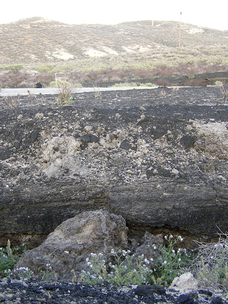
 The McKittrick Tar Pits (also McKittrick Oil Seeps and McKittrick Brea Pits) are a series of natural asphalt lakes
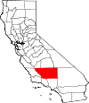
situated in the western part of Kern County
in southern California. The pits are the most extensive asphalt lakes in the state.
The McKittrick Tar Pits are one of the five natural asphalt lake areas in the world, the others being Tierra de Brea
in Trinidad and Tobago
, Lake Guanoco
in Venezuela
and the Rancho La Brea Tar Pits
(Los Angeles) and Carpinteria Tar Pits
(Carpinteria
) both also located in the US state of California.
about 50 km (31.1 mi) west of Bakersfield
and 0.8 km (0.497098189319845 mi) south of the town of McKittrick
.
Most of the tar pits are located along the south western part of the intersection of California State Route 58
and 33
and generate from the underlying McKittrick Oil Field
. The pits stretch over a distance of about 6.5 km (4 mi).
epoch
and share the same geological principle.
The creation of an asphalt lake is related to deep faults
between two tectonic plates
. In connection with subduction
, pressure is created against underlying oil source rock
.
The oil moves towards the surface and slowly transforms into bitumen and on the way through the lithosphere
picks up clay and water, and is cooled into asphalt. Lighter hydrocarbon fractions volatilize on contact with the atmosphere, leaving behind the heavier fractions, which are principally asphaltum.
In the 1860s, San Joaquin Valley settlers mined the tar pits both from open pits and shafts and the first commercial exploitation occurred by the "Buena Vista Petroleum Company".
The tar pits have trapped and preserved hundreds of Pleistocene Age birds and animals The first paleontological studies were conducted between 1900 and 1910, in 1928 the first major studies were conducted by a paleontological team from the University of California
, the excavations were completed in 1949 by teams from the Natural History Museum of Los Angeles County
and the Kern County Museum
. By 1968 more than 43 different mammals and 58 different birds had been identified.
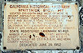
On June 29, 1952 the McKittrick Tar Pits were registered a California Historical Landmark.
Tar pit
A tar pit, or more accurately known as an asphalt pit or asphalt lake, is a geological occurrence where subterranean bitumen leaks to the surface, creating a large area of natural asphalt.-Known tar pits:...
situated in the western part of Kern County
Kern County, California
Spreading across the southern end of the California Central Valley, Kern County is the fifth-largest county by population in California. Its economy is heavily linked to agriculture and to petroleum extraction, and there is a strong aviation and space presence. Politically, it has generally...
in southern California. The pits are the most extensive asphalt lakes in the state.
The McKittrick Tar Pits are one of the five natural asphalt lake areas in the world, the others being Tierra de Brea
Pitch Lake
The Pitch Lake is the largest natural deposit of asphalt in the world, located at La Brea in southwest Trinidad, within the Siparia Regional Corporation. The lake covers about 40 ha and is reported to be 75 m deep....
in Trinidad and Tobago
Trinidad and Tobago
Trinidad and Tobago officially the Republic of Trinidad and Tobago is an archipelagic state in the southern Caribbean, lying just off the coast of northeastern Venezuela and south of Grenada in the Lesser Antilles...
, Lake Guanoco
Lake Bermudez
Lake Guanoco is the world's second largest natural asphalt lake and lies in Venezuela in northern South America....
in Venezuela
Venezuela
Venezuela , officially called the Bolivarian Republic of Venezuela , is a tropical country on the northern coast of South America. It borders Colombia to the west, Guyana to the east, and Brazil to the south...
and the Rancho La Brea Tar Pits
La Brea Tar Pits
The La Brea Tar Pits are a cluster of tar pits around which Hancock Park was formed, in the urban heart of Los Angeles. Asphaltum or tar has seeped up from the ground in this area for tens of thousands of years. The tar is often covered with water...
(Los Angeles) and Carpinteria Tar Pits
Carpinteria Tar Pits
The Carpinteria Tar Pits are a series of natural asphalt lakes situated in the southern part of Santa Barbara County in southern California....
(Carpinteria
Carpinteria, California
Carpinteria is a small oceanside city located in southeastern Santa Barbara County, California, east of Santa Barbara and northwest of Ventura. The population was 13,040 at the 2010 census, down from 14,194 at the 2000 census....
) both also located in the US state of California.
Geography
The McKittrick Tar Pits are located in the southern part of the San Joaquin ValleySan Joaquin Valley
The San Joaquin Valley is the area of the Central Valley of California that lies south of the Sacramento – San Joaquin River Delta in Stockton...
about 50 km (31.1 mi) west of Bakersfield
Bakersfield, California
Bakersfield is a city near the southern end of the San Joaquin Valley in Kern County, California. It is roughly equidistant between Fresno and Los Angeles, to the north and south respectively....
and 0.8 km (0.497098189319845 mi) south of the town of McKittrick
McKittrick, California
McKittrick is a census-designated place in Kern County, California, United States. McKittrick is located northwest of Taft, at an elevation of 1056 feet . The population was 115 at the 2010 census, down from 160 at the 2000 census.-Geography:...
.
Most of the tar pits are located along the south western part of the intersection of California State Route 58
California State Route 58
State Route 58 is an east-west highway across the California Coast Ranges, the southern San Joaquin Valley, the Tehachapi Mountains, which border the southern Sierra Nevada, and the Mojave Desert. It runs between its western terminus near Santa Margarita and its eastern terminus at Barstow...
and 33
California State Route 33
State Route 33 is a north–south state highway in the U.S. state of California. SR 33 replaced part of U.S. Route 399 in 1964 during the "great renumbering" of routes. In the unincorporated sections of Kern County it is known as the West Side Highway...
and generate from the underlying McKittrick Oil Field
McKittrick Oil Field
The McKittrick Oil Field is a large oil and gas field in western Kern County, California. The town of McKittrick overlies the northeastern portion of the oil field...
. The pits stretch over a distance of about 6.5 km (4 mi).
Geology
All asphalt lakes were probably created during the PleistocenePleistocene
The Pleistocene is the epoch from 2,588,000 to 11,700 years BP that spans the world's recent period of repeated glaciations. The name pleistocene is derived from the Greek and ....
epoch
Epoch (geology)
An epoch is a subdivision of the geologic timescale based on rock layering. In order, the higher subdivisions are periods, eras and eons. We are currently living in the Holocene epoch...
and share the same geological principle.
The creation of an asphalt lake is related to deep faults
Geologic fault
In geology, a fault is a planar fracture or discontinuity in a volume of rock, across which there has been significant displacement along the fractures as a result of earth movement. Large faults within the Earth's crust result from the action of tectonic forces...
between two tectonic plates
Tectonic Plates
Tectonic Plates is a 1992 independent Canadian film directed by Peter Mettler. Mettler also wrote the screenplay based on the play by Robert Lepage. The film stars Marie Gignac, Céline Bonnier and Robert Lepage.-Plot summary:...
. In connection with subduction
Subduction
In geology, subduction is the process that takes place at convergent boundaries by which one tectonic plate moves under another tectonic plate, sinking into the Earth's mantle, as the plates converge. These 3D regions of mantle downwellings are known as "Subduction Zones"...
, pressure is created against underlying oil source rock
Source rock
In petroleum geology, source rock refers to rocks from which hydrocarbons have been generated or are capable of being generated. They form one of the necessary elements of a working petroleum system. They are organic-rich sediments that may have been deposited in a variety of environments including...
.
The oil moves towards the surface and slowly transforms into bitumen and on the way through the lithosphere
Lithosphere
The lithosphere is the rigid outermost shell of a rocky planet. On Earth, it comprises the crust and the portion of the upper mantle that behaves elastically on time scales of thousands of years or greater.- Earth's lithosphere :...
picks up clay and water, and is cooled into asphalt. Lighter hydrocarbon fractions volatilize on contact with the atmosphere, leaving behind the heavier fractions, which are principally asphaltum.
History
It is unknown when the McKittrick Tar Pits were discovered, as they have been known for a long time by the local Native American Yokut people who mined the asphalt and used it as a sealant for waterproofing, decoration, and even for trade.In the 1860s, San Joaquin Valley settlers mined the tar pits both from open pits and shafts and the first commercial exploitation occurred by the "Buena Vista Petroleum Company".
The tar pits have trapped and preserved hundreds of Pleistocene Age birds and animals The first paleontological studies were conducted between 1900 and 1910, in 1928 the first major studies were conducted by a paleontological team from the University of California
University of California
The University of California is a public university system in the U.S. state of California. Under the California Master Plan for Higher Education, the University of California is a part of the state's three-tier public higher education system, which also includes the California State University...
, the excavations were completed in 1949 by teams from the Natural History Museum of Los Angeles County
Natural History Museum of Los Angeles County
The Natural History Museum of Los Angeles County opened in Exposition Park, Los Angeles, California, USA in 1913 as the Museum of History, Science, and Art. The moving force behind it was a museum association founded in 1910. Its distinctive main building, with fitted marble walls and domed and...
and the Kern County Museum
Kern County Museum
The Kern County Museum is a history museum located in Bakersfield, California. Its main focus is the history of Kern County . One of the prominent features is Pioneer Village. Located on , it contains over 50 original buildings from around the county, related to life in the late 19th century...
. By 1968 more than 43 different mammals and 58 different birds had been identified.
On June 29, 1952 the McKittrick Tar Pits were registered a California Historical Landmark.