

Carpinteria Tar Pits
Encyclopedia
34°23′30.98"N 119°31′16.44"W
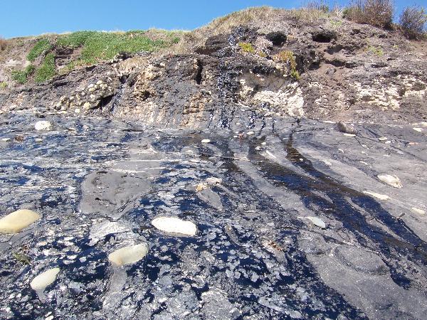
The Carpinteria Tar Pits (also Carpinteria Oil Seeps) are a series of natural asphalt lakes
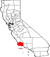
situated in the southern part of Santa Barbara County
in southern California.
The Carpinteria Tar Pits are one of the five natural asphalt lake areas in the world, the others being Tierra de Brea
in Trinidad and Tobago
, Lake Guanoco
in Venezuela
and the Rancho La Brea Tar Pits
(Los Angeles) and McKittrick Tar Pits
(McKittrick
) both also located in the US state of California.
in the town of Carpinteria
.
The area is a designated park, the Tar Pits Park, and lies within the Carpinteria State Beach
area in the southern part between the Santa Rosa and the San Miguel campsites. Most of the tar pits are located along a short stretch directly on the beach and generate from the underlying Carpinteria Offshore Oil Field
.
epoch
.
The creation of an asphalt lake is typically the result of upwards migrations of hydrocarbons along a geologic fault
. Additionally, in connection with subduction
pressure can be created against underlying oil source rock
.
The oil is moving towards the surface and slowly transforming into bitumen; and, on the way through the lithosphere
, it is picking up clay and water and is cooled into asphalt.
s (plank-built boats) and other utilities.
The area was named "La carpinteria" (carpentry) on August 17, 1769, by a Spanish expedition under explorer Gaspar de Portolà
.
In the 1920s around 1915 the tar pits were mined and the asphalt was used for building the coastal highway. The tar pits have trapped and preserved hundreds of Pleistocene Age birds and animals but paleontological studies were not conducted as the tar pits later on were used as a local rubbish dump.
However some findings are on display at the Carpinteria Valley Museum of History
.
In 1933 the area was designated a state beach and in 1941 it was formally opened to the public.
The Carpinteria Tar Pits (also Carpinteria Oil Seeps) are a series of natural asphalt lakes
Tar pit
A tar pit, or more accurately known as an asphalt pit or asphalt lake, is a geological occurrence where subterranean bitumen leaks to the surface, creating a large area of natural asphalt.-Known tar pits:...
situated in the southern part of Santa Barbara County
Santa Barbara County, California
Santa Barbara County is a county located in the southern portion of the U.S. state of California, on the Pacific coast. As of 2010 the county had a population of 423,895. The county seat is Santa Barbara and the largest city is Santa Maria.-History:...
in southern California.
The Carpinteria Tar Pits are one of the five natural asphalt lake areas in the world, the others being Tierra de Brea
Pitch Lake
The Pitch Lake is the largest natural deposit of asphalt in the world, located at La Brea in southwest Trinidad, within the Siparia Regional Corporation. The lake covers about 40 ha and is reported to be 75 m deep....
in Trinidad and Tobago
Trinidad and Tobago
Trinidad and Tobago officially the Republic of Trinidad and Tobago is an archipelagic state in the southern Caribbean, lying just off the coast of northeastern Venezuela and south of Grenada in the Lesser Antilles...
, Lake Guanoco
Lake Bermudez
Lake Guanoco is the world's second largest natural asphalt lake and lies in Venezuela in northern South America....
in Venezuela
Venezuela
Venezuela , officially called the Bolivarian Republic of Venezuela , is a tropical country on the northern coast of South America. It borders Colombia to the west, Guyana to the east, and Brazil to the south...
and the Rancho La Brea Tar Pits
La Brea Tar Pits
The La Brea Tar Pits are a cluster of tar pits around which Hancock Park was formed, in the urban heart of Los Angeles. Asphaltum or tar has seeped up from the ground in this area for tens of thousands of years. The tar is often covered with water...
(Los Angeles) and McKittrick Tar Pits
McKittrick Tar Pits
The McKittrick Tar Pits are a series of natural asphalt lakes situated in the western part of Kern County in southern California. The pits are the most extensive asphalt lakes in the state...
(McKittrick
McKittrick, California
McKittrick is a census-designated place in Kern County, California, United States. McKittrick is located northwest of Taft, at an elevation of 1056 feet . The population was 115 at the 2010 census, down from 160 at the 2000 census.-Geography:...
) both also located in the US state of California.
Geography
The Carpinteria Tar Pits are located in the southeastern extremity of Santa Barbara County about 20 km (12.4 mi) southeast of Santa BarbaraSanta Barbara, California
Santa Barbara is the county seat of Santa Barbara County, California, United States. Situated on an east-west trending section of coastline, the longest such section on the West Coast of the United States, the city lies between the steeply-rising Santa Ynez Mountains and the Pacific Ocean...
in the town of Carpinteria
Carpinteria, California
Carpinteria is a small oceanside city located in southeastern Santa Barbara County, California, east of Santa Barbara and northwest of Ventura. The population was 13,040 at the 2010 census, down from 14,194 at the 2000 census....
.
The area is a designated park, the Tar Pits Park, and lies within the Carpinteria State Beach
Carpinteria State Beach
Carpinteria State Beach is a protected beach in the state park system of California, USA. It is located south of Santa Barbara in the city of Carpinteria. The park has of beachfront. Recreational activities include swimming, surf fishing, camping, and tidepool exploration. The park was...
area in the southern part between the Santa Rosa and the San Miguel campsites. Most of the tar pits are located along a short stretch directly on the beach and generate from the underlying Carpinteria Offshore Oil Field
Carpinteria Offshore Oil Field
The Carpinteria Offshore Oil Field is an oil and gas field in Santa Barbara Channel, south of the city of Carpinteria in southern California in the United States...
.
Geology
The Carpinteria Tar Pits probably date from the PleistocenePleistocene
The Pleistocene is the epoch from 2,588,000 to 11,700 years BP that spans the world's recent period of repeated glaciations. The name pleistocene is derived from the Greek and ....
epoch
Epoch (geology)
An epoch is a subdivision of the geologic timescale based on rock layering. In order, the higher subdivisions are periods, eras and eons. We are currently living in the Holocene epoch...
.
The creation of an asphalt lake is typically the result of upwards migrations of hydrocarbons along a geologic fault
Geologic fault
In geology, a fault is a planar fracture or discontinuity in a volume of rock, across which there has been significant displacement along the fractures as a result of earth movement. Large faults within the Earth's crust result from the action of tectonic forces...
. Additionally, in connection with subduction
Subduction
In geology, subduction is the process that takes place at convergent boundaries by which one tectonic plate moves under another tectonic plate, sinking into the Earth's mantle, as the plates converge. These 3D regions of mantle downwellings are known as "Subduction Zones"...
pressure can be created against underlying oil source rock
Source rock
In petroleum geology, source rock refers to rocks from which hydrocarbons have been generated or are capable of being generated. They form one of the necessary elements of a working petroleum system. They are organic-rich sediments that may have been deposited in a variety of environments including...
.
The oil is moving towards the surface and slowly transforming into bitumen; and, on the way through the lithosphere
Lithosphere
The lithosphere is the rigid outermost shell of a rocky planet. On Earth, it comprises the crust and the portion of the upper mantle that behaves elastically on time scales of thousands of years or greater.- Earth's lithosphere :...
, it is picking up clay and water and is cooled into asphalt.
History
It is unknown when the Carpinteria Tar Pits were discovered, they have been known for a long time by the local Native American Chumash people who mined the asphalt and used it as a sealant for waterproofing their tomolTomol
Tomols are plank-built boats, historically and currently used by the Chumash and Tongva Native Americans in the Santa Barbara and Los Angeles area. They were also called tii'at by the Tongva. Tomols are long. They were especially important as both tribes relied on the sea for...
s (plank-built boats) and other utilities.
The area was named "La carpinteria" (carpentry) on August 17, 1769, by a Spanish expedition under explorer Gaspar de Portolà
Gaspar de Portolà
Gaspar de Portolà i Rovira was a soldier, governor of Baja and Alta California , explorer and founder of San Diego and Monterey. He was born in Os de Balaguer, province of Lleida, in Catalonia, Spain, of Catalan nobility. Don Gaspar served as a soldier in the Spanish army in Italy and Portugal...
.
In the 1920s around 1915 the tar pits were mined and the asphalt was used for building the coastal highway. The tar pits have trapped and preserved hundreds of Pleistocene Age birds and animals but paleontological studies were not conducted as the tar pits later on were used as a local rubbish dump.
However some findings are on display at the Carpinteria Valley Museum of History
Carpinteria Valley Museum of History
The Carpinteria Valley Museum of History is a museum located in Carpinteria, California. It is operated by the non-profit Carpinteria Valley Historical Society primarily through membership dues, memorial donations, endowment income and fund-raising activities...
.
In 1933 the area was designated a state beach and in 1941 it was formally opened to the public.