
McCroskey State Park
Encyclopedia
McCroskey State Park is a state park
of Idaho
, USA, stretching along a ridge
in the Palouse
region. At 5300 acres (21 km²) this wilderness area is Idaho's second-largest state park. The park is located in Latah
and Benewah Counties
along the border of Washington.
, who gradually bought up land endangered by logging and cobbled his purchases into a 4400 acres (18 km²) parcel. To make the land more attractive to tourists, he cut viewpoints into some of the slopes, built picnic areas, planted flowers, and established a road. The Idaho legislature, however, had serious doubts about the new park – thinking it would not generate enough revenue to justify the loss in taxes – and agreed to accept the gift only if McCroskey, then in his late seventies, would maintain the park at his own expense for the next fifteen years. McCroskey accepted the terms, and lived exactly fifteen more years, fulfilling his obligation to the state of Idaho just weeks before his death in 1970 at age 93.
McCroskey named the park in honour of his mother, a pioneer woman who came to Eastern Washington with her husband and children to establish a homestead near Steptoe Butte
; he dedicated it to all pioneer women.
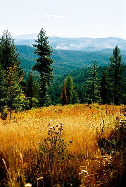 McCroskey State Park occupies the rocky slopes of Skyline Ridge on Mineral Mountain, in a transitional zone between the palouse
prairie to the west and the Rocky Mountains
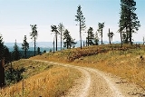
to the east. The park's chief attraction is a narrow unimproved road called Skyline Drive, which winds for 18 miles (29 km) along a steep ridge, climbing through dense cedar forest that gives way to stands of ponderosa pine and, eventually, to prairie
. The road also links a scattering of interpretive signs and vista points. In addition, there are 32 miles (51.5 km) of trails open to hiking, mountain biking
, horses, and all-terrain vehicle
s. Picnic areas, pit toilets and primitive campsites are available, along with a single source of drinking water near the midpoint of Skyline Drive. Since the park is large, remote, and underutilized, it provides excellent habitat for an assortment of wildlife, including deer, moose, and black bears. Despite McCroskey's "park" status, however, significant logging
still takes place within park boundaries.
The park lies about 10 miles (16 km) north of Potlatch, Idaho
. The best access point is from Highway 95
, but visitors can also enter the park from Farmington road on the west side, a few miles north of Farmington, Washington
. On the Farmington side, the only indication of the park's presence is the Skyline Drive sign, and the roads are much rougher.
State park
State parks are parks or other protected areas managed at the federated state level within those nations which use "state" as a political subdivision. State parks are typically established by a state to preserve a location on account of its natural beauty, historic interest, or recreational...
of Idaho
Idaho
Idaho is a state in the Rocky Mountain area of the United States. The state's largest city and capital is Boise. Residents are called "Idahoans". Idaho was admitted to the Union on July 3, 1890, as the 43rd state....
, USA, stretching along a ridge
Ridge
A ridge is a geological feature consisting of a chain of mountains or hills that form a continuous elevated crest for some distance. Ridges are usually termed hills or mountains as well, depending on size. There are several main types of ridges:...
in the Palouse
Palouse
The Palouse is a region of the northwestern United States, encompassing parts of southeastern Washington, north central Idaho and, in some definitions, extending south into northeast Oregon. It is a major agricultural area, primarily producing wheat and legumes...
region. At 5300 acres (21 km²) this wilderness area is Idaho's second-largest state park. The park is located in Latah
Latah County, Idaho
Latah County is a county located in the north central region of the U.S. state of Idaho. The population was 37,244 at the 2010 census. The county seat and largest city is Moscow, which is the home of the University of Idaho, the state's flagship and land-grant university...
and Benewah Counties
Benewah County, Idaho
Benewah County is a county located in the U.S. state of Idaho. Established on January 23, 1915, from sections of Kootenai County, it was named for a chief of the Coeur d'Alene Tribe. As of the 2010 census the county had a population of 9,285. The county seat and largest city is St...
along the border of Washington.
History
McCroskey State Park was gifted to Idaho in 1955 by a local conservationist, Virgil T. McCroskeyVirgil T. McCroskey
Virgil Talmadge McCroskey was an American conservationist who spent most of his life in Eastern Washington...
, who gradually bought up land endangered by logging and cobbled his purchases into a 4400 acres (18 km²) parcel. To make the land more attractive to tourists, he cut viewpoints into some of the slopes, built picnic areas, planted flowers, and established a road. The Idaho legislature, however, had serious doubts about the new park – thinking it would not generate enough revenue to justify the loss in taxes – and agreed to accept the gift only if McCroskey, then in his late seventies, would maintain the park at his own expense for the next fifteen years. McCroskey accepted the terms, and lived exactly fifteen more years, fulfilling his obligation to the state of Idaho just weeks before his death in 1970 at age 93.
McCroskey named the park in honour of his mother, a pioneer woman who came to Eastern Washington with her husband and children to establish a homestead near Steptoe Butte
Steptoe Butte
Steptoe Butte is a quartzite island jutting out of the silty loess of the Palouse hills in Whitman County, Washington. It is contained by Steptoe Butte State Park. The rock that forms the butte is over 400 million years old, in contrast with the 15–7 million year old Columbia River basalts that...
; he dedicated it to all pioneer women.
Description
Palouse
The Palouse is a region of the northwestern United States, encompassing parts of southeastern Washington, north central Idaho and, in some definitions, extending south into northeast Oregon. It is a major agricultural area, primarily producing wheat and legumes...
prairie to the west and the Rocky Mountains
Rocky Mountains
The Rocky Mountains are a major mountain range in western North America. The Rocky Mountains stretch more than from the northernmost part of British Columbia, in western Canada, to New Mexico, in the southwestern United States...
to the east. The park's chief attraction is a narrow unimproved road called Skyline Drive, which winds for 18 miles (29 km) along a steep ridge, climbing through dense cedar forest that gives way to stands of ponderosa pine and, eventually, to prairie
Prairie
Prairies are considered part of the temperate grasslands, savannas, and shrublands biome by ecologists, based on similar temperate climates, moderate rainfall, and grasses, herbs, and shrubs, rather than trees, as the dominant vegetation type...
. The road also links a scattering of interpretive signs and vista points. In addition, there are 32 miles (51.5 km) of trails open to hiking, mountain biking
Mountain biking
Mountain biking is a sport which consists of riding bicycles off-road, often over rough terrain, using specially adapted mountain bikes. Mountain bikes share similarities with other bikes, but incorporate features designed to enhance durability and performance in rough terrain.Mountain biking can...
, horses, and all-terrain vehicle
All-terrain vehicle
An all-terrain vehicle , also known as a quad, quad bike, three wheeler, or four wheeler, is defined by the American National Standards Institute as a vehicle that travels on low pressure tires, with a seat that is straddled by the operator, along with handlebars for steering control...
s. Picnic areas, pit toilets and primitive campsites are available, along with a single source of drinking water near the midpoint of Skyline Drive. Since the park is large, remote, and underutilized, it provides excellent habitat for an assortment of wildlife, including deer, moose, and black bears. Despite McCroskey's "park" status, however, significant logging
Logging
Logging is the cutting, skidding, on-site processing, and loading of trees or logs onto trucks.In forestry, the term logging is sometimes used in a narrow sense concerning the logistics of moving wood from the stump to somewhere outside the forest, usually a sawmill or a lumber yard...
still takes place within park boundaries.
The park lies about 10 miles (16 km) north of Potlatch, Idaho
Potlatch, Idaho
Potlatch is a city in Latah County, Idaho, United States. The population was 791 at the 2000 census.-History:Potlatch was founded in 1905 as a company town by the Potlach Corporation. The townsite was chosen because of proximity to Potlatch Corporation's large holdings of western white pine on the...
. The best access point is from Highway 95
U.S. Route 95
U.S. Route 95 is a north–south U.S. highway in the western United States. Unlike many other US highways, it has not seen deletion or replacement on most of its length by an encroaching Interstate highway corridor, due to its mostly rural course...
, but visitors can also enter the park from Farmington road on the west side, a few miles north of Farmington, Washington
Farmington, Washington
Farmington is a town in Whitman County, Washington, United States. The population was 146 at the 2010 census.-History:Farmington was first settled in 1871, and was founded and named by G.W.Truax in 1878. Farmington was officially incorporated in 1888. At Farmington's peak the town boasted a...
. On the Farmington side, the only indication of the park's presence is the Skyline Drive sign, and the roads are much rougher.