

Map of Juan de la Cosa
Encyclopedia
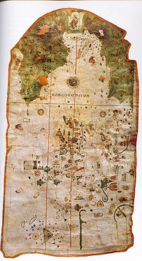
Mappa mundi
Mappa mundi is a general term used to describe medieval European maps of the world. These maps range in size and complexity from simple schematic maps an inch or less across to elaborate wall maps, the largest of which was 11 ft. in diameter...
painted on parchment
Parchment
Parchment is a thin material made from calfskin, sheepskin or goatskin, often split. Its most common use was as a material for writing on, for documents, notes, or the pages of a book, codex or manuscript. It is distinct from leather in that parchment is limed but not tanned; therefore, it is very...
, 93 cm high and 183 cm wide, currently preserved at the Museo Naval of Madrid
Madrid
Madrid is the capital and largest city of Spain. The population of the city is roughly 3.3 million and the entire population of the Madrid metropolitan area is calculated to be 6.271 million. It is the third largest city in the European Union, after London and Berlin, and its metropolitan...
(Spain
Spain
Spain , officially the Kingdom of Spain languages]] under the European Charter for Regional or Minority Languages. In each of these, Spain's official name is as follows:;;;;;;), is a country and member state of the European Union located in southwestern Europe on the Iberian Peninsula...
). A line of text on the map says it was made by cartographer and sailor Juan de la Cosa
Juan de la Cosa
Juan de la Cosa was a Spanish cartographer, conquistador and explorer. He made the earliest extant European world map to incorporate the territories of the Americas that were discovered in the 15th century, sailed first 3 voyages with Christopher Columbus, and was the owner/captain of the Santa...
in 1500 in the Andalusia
Andalusia
Andalusia is the most populous and the second largest in area of the autonomous communities of Spain. The Andalusian autonomous community is officially recognised as a nationality of Spain. The territory is divided into eight provinces: Huelva, Seville, Cádiz, Córdoba, Málaga, Jaén, Granada and...
n port city of Puerto de Santa María. Its rich decoration hints that it was ordered by some powerful member of the court of the Catholic Monarchs
Catholic Monarchs
The Catholic Monarchs is the collective title used in history for Queen Isabella I of Castile and King Ferdinand II of Aragon. They were both from the House of Trastámara and were second cousins, being both descended from John I of Castile; they were given a papal dispensation to deal with...
, who ruled the kingdoms of Castile
Crown of Castile
The Crown of Castile was a medieval and modern state in the Iberian Peninsula that formed in 1230 as a result of the third and definitive union of the crowns and parliaments of the kingdoms of Castile and León upon the accession of the then King Ferdinand III of Castile to the vacant Leonese throne...
and Aragon
Crown of Aragon
The Crown of Aragon Corona d'Aragón Corona d'Aragó Corona Aragonum controlling a large portion of the present-day eastern Spain and southeastern France, as well as some of the major islands and mainland possessions stretching across the Mediterranean as far as Greece...
at that time.
This map is the earliest undisputed representation of the Americas. Some historians have claimed that some of the Antilles
Antilles
The Antilles islands form the greater part of the West Indies in the Caribbean Sea. The Antilles are divided into two major groups: the "Greater Antilles" to the north and west, including the larger islands of Cuba, Jamaica, Hispaniola , and Puerto Rico; and the smaller "Lesser Antilles" on the...
appear on earlier maps such as the Pizzigano map
Pizzigano Map
The Pizzigano Map is a portolan chart dated to 1424 and attributed to the 15th C. Venetian cartographer Zuane Pizzigano...
of 1424 but there is no consensus about it. Furthermore, the Vinland map
Vinland map
The Vinland map is claimed to be a 15th century mappa mundi with unique information about Norse exploration of America. It is very well known because of the publicity campaign which accompanied its revelation to the public as a "genuine" pre-Columbian map in 1965...
shows part of North America but its dating is controversial. The La Cosa map shows the lands discovered up to the end of the 15th century by Castilian, Portuguese
Portugal
Portugal , officially the Portuguese Republic is a country situated in southwestern Europe on the Iberian Peninsula. Portugal is the westernmost country of Europe, and is bordered by the Atlantic Ocean to the West and South and by Spain to the North and East. The Atlantic archipelagos of the...
and English
England
England is a country that is part of the United Kingdom. It shares land borders with Scotland to the north and Wales to the west; the Irish Sea is to the north west, the Celtic Sea to the south west, with the North Sea to the east and the English Channel to the south separating it from continental...
expeditions to America
Americas
The Americas, or America , are lands in the Western hemisphere, also known as the New World. In English, the plural form the Americas is often used to refer to the landmasses of North America and South America with their associated islands and regions, while the singular form America is primarily...
. It also depicts a large fraction of the Old World
Old World
The Old World consists of those parts of the world known to classical antiquity and the European Middle Ages. It is used in the context of, and contrast with, the "New World" ....
, according to the style of medieval portolan chart
Portolan chart
Portolan charts are navigational maps based on realistic descriptions of harbours and coasts. They were first made in the 14th century in Italy, Portugal and Spain...
s and including news of the arrival of Vasco de Gama to India
India
India , officially the Republic of India , is a country in South Asia. It is the seventh-largest country by geographical area, the second-most populous country with over 1.2 billion people, and the most populous democracy in the world...
in 1498.
The map of Juan de la Cosa is the only cartographic work made by an eyewitness of the first voyages of Christopher Columbus
Christopher Columbus
Christopher Columbus was an explorer, colonizer, and navigator, born in the Republic of Genoa, in northwestern Italy. Under the auspices of the Catholic Monarchs of Spain, he completed four voyages across the Atlantic Ocean that led to general European awareness of the American continents in the...
to the Indies
Indies
The Indies is a term that has been used to describe the lands of South and Southeast Asia, occupying all of the present India, Pakistan, Bangladesh, Myanmar, Nepal, Sri Lanka, the Maldives, and also Thailand, Cambodia, Laos, Vietnam, Brunei, Singapore, the Philippines, East Timor, Malaysia and...
that has been preserved. Possibly as an allusion to Columbus, it contains a large image of Saint Christopher
Saint Christopher
.Saint Christopher is a saint venerated by Roman Catholics and Orthodox Christians, listed as a martyr killed in the reign of the 3rd century Roman Emperor Decius or alternatively under the Roman Emperor Maximinus II Dacian...
that covers the region where Central America
Central America
Central America is the central geographic region of the Americas. It is the southernmost, isthmian portion of the North American continent, which connects with South America on the southeast. When considered part of the unified continental model, it is considered a subcontinent...
should have appeared. On the other hand, Cuba
Cuba
The Republic of Cuba is an island nation in the Caribbean. The nation of Cuba consists of the main island of Cuba, the Isla de la Juventud, and several archipelagos. Havana is the largest city in Cuba and the country's capital. Santiago de Cuba is the second largest city...
is drawn as an island, which contradicts Columbus' opinion that it was a peninsula of Asia.
External links
Images- High-resolution digital image, made by TALLERdigigráfico
Texts
- J. Siebold, , Slide #305 Monograph
- Luis A. Robles Macias Juan de la Cosa’s Projection: A Fresh Analysis of the Earliest Preserved Map of the Americas, Coordinates, Series A nº. 9, 24 May 2010. Spanish version: La proyección de Juan de la Cosa.