
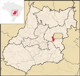
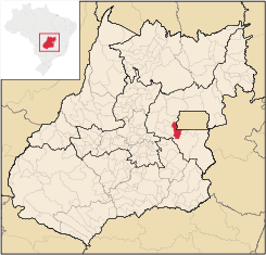
Santo Antônio do Descoberto
Encyclopedia
| Santo Antônio do Descoberto | |
|---|---|
| State | Goiás Goiás Goiás is a state of Brazil, located in the central part of the country. The name Goiás comes from the name of an indigenous community... |
| Coordinates: | 15°56′37"S 48°15′34"W |
| Area: | 938.3 km² |
| Population: | 55,621 (IBGE 2007) |
| Population Density: | 59.28 inhab/km² (2007) |
| Urban population: | 52,083 |
| Elevation: | 912 m above sea level |
| Postcode (CEP): | 72900-000 |
| Became a city: | 1982 |
| Mayor: | David Leite (2009-2012) |
| IBGE statistical region: | Entorno de Brasília |
| Website: | none |
City
A city is a relatively large and permanent settlement. Although there is no agreement on how a city is distinguished from a town within general English language meanings, many cities have a particular administrative, legal, or historical status based on local law.For example, in the U.S...
and municipality
Municipality
A municipality is essentially an urban administrative division having corporate status and usually powers of self-government. It can also be used to mean the governing body of a municipality. A municipality is a general-purpose administrative subdivision, as opposed to a special-purpose district...
in central Goiás
Goiás
Goiás is a state of Brazil, located in the central part of the country. The name Goiás comes from the name of an indigenous community...
state, Brazil
Brazil
Brazil , officially the Federative Republic of Brazil , is the largest country in South America. It is the world's fifth largest country, both by geographical area and by population with over 192 million people...
. It is a suburb of Brasília
Brasília
Brasília is the capital city of Brazil. The name is commonly spelled Brasilia in English. The city and its District are located in the Central-West region of the country, along a plateau known as Planalto Central. It has a population of about 2,557,000 as of the 2008 IBGE estimate, making it the...
that was a sleepy country hamlet until the population exploded in the 1970s due to the construction of the national capital. The Areias River
Areias River (Goiás)
The Areias River is a river of Goiás state in central Brazil. Part of the Paraná River watershed, its source is located near the Serra dos Pirineus, and flows into the Corumbá River.Its approximate length is sixty miles...
passes through the municipality.
Location
Santo Antônio do Descoberto is located in the microregion called Entorno de Brasília, the area of Goiás that surrounds the federal capital. It is 174 km. from the state capital of GoiâniaGoiânia
-Climate:The city has a tropical wet and dry climate with an average temperature of . There's a wet season, from October to April, and a dry one, from May to September. Annual rainfall is around 1,520 mm....
.
Municipal boundaries are with:
- North: Águas Lindas de GoiásÁguas Lindas de GoiásÁguas Lindas de Goiás is a city and municipality located in central Goiás, Brazil. It is the fifth largest city in the state and one of the fastest growing cities in Brazil.-Location:...
- South: LuziâniaLuziâniaLuziânia is a city and municipality in the state of Goiás, Brazil. This fast-growing city is a great producer of agricultural products including soybeans and beans.-Location:Luziânia is located 68 km...
- East: Cocalzinho de GoiásCocalzinho de GoiásCocalzinho de Goiás is a small town and municipality in central Goiás state, Brazil.-Location and Geography:Cocalzinho, as it is known by the inhabitants, is located in the micro-region of Entorno de Brasília, on highway BR-414, almost at the junction with highway BR-070...
, Corumbá de GoiásCorumbá de GoiásCorumbá de Goiás is a small town and municipality in central Goiás state, Brazil. It is one of the oldest cities in the state and still preserves vestiges of its colonial heritage...
, and AlexâniaAlexâniaAlexânia is a small town and municipality in central Goiás state, Brazil. Alexânia is known for its alleged extraterrestrial sightings in the late sixties and early seventies. The Areias River passes through the municipality.-Location:... - West: BrasíliaBrasíliaBrasília is the capital city of Brazil. The name is commonly spelled Brasilia in English. The city and its District are located in the Central-West region of the country, along a plateau known as Planalto Central. It has a population of about 2,557,000 as of the 2008 IBGE estimate, making it the...
Economy
The economy is based on agriculture, cattle raising, services, public administration, and small transformation industries. There were 02 financial institutions in August 2007. The cattle herd had 31,000 head (2006) and the main crops planted were rice, sugarcane, beans, bananas, oranges, manioc, and corn (1,200 hectares 2006))Agricultural data 2006
- Farms: 532
- Total area: 27,819 ha.
- Area of permanent crops: 1,203 ha.
- Area of perennial crops: 3,502 ha.
- Area of natural pasture: 15,906 ha.
- Area of woodland and forests: 9,580 ha.
- Persons dependent on farming: 1,450
- Number of tractors: 66 IBGE
Health and education
- Higher education: Pólo Universitário da UEG.
- Adult literacy rate: 85.7% (2000) (national average was 86.4%)
- Hospitals: 2 with 77 beds (2007)
- Infant mortality rate: 26.65 (2000) (national average was 33.0)
- Human Development IndexHuman Development IndexThe Human Development Index is a composite statistic used to rank countries by level of "human development" and separate "very high human development", "high human development", "medium human development", and "low human development" countries...
: 0.709 (2000) - State ranking: 199 (out of 242 municipalities)
- National ranking: 2,843 (out of 5,507 municipalities) Frigoletto
Tourism
The municipality attracts visitors to its waterfalls, caves and springs of crystal-clear water. Two of the water falls, lying 5 kilometers from the town, are surrounded by dense tropical vegetation, contrasting with the relatively dry cerrado nearby.Ten kilometers from the town is Cidade Eclética
Cidade Eclética
Cidade Eclética is a religious commune founded by the spiritualist Mestre Yokaanam , and is located 62 km west of Brasília, Brazil, in the state of Goiás. It belongs to the municipality of Santo Antonio do Descoberto. It has a population of around 1,500 persons, of whom 790 were registered to...
, a nucleus of people who make up a universal fraternity, a spiritualist community founded by Oceano de Sá, known as Mestre Yokaanam.
The traditional festival of Santo Antônio do Descoberto is in homage to the patron saint and takes place on 13 June. It attracts thousands of pilgrims and followers of the saint and there are stands, processions and music.
History
The history of European occupation of the region of Santo Antônio goes back to 1726 when, according to tradition, slaves belonging a Portuguese gold seeker sat down to rest and supposedly discovered an image of Santo Antônio in the branches of a tree. They took it to their master and a chapel was built in 1728. Soon the site became a place of pilgrimage attracting people from near and far. After a time the festivals disappeared and the town continued with the name of Santo Antônio de Montes Claros, district of LuziâniaLuziânia
Luziânia is a city and municipality in the state of Goiás, Brazil. This fast-growing city is a great producer of agricultural products including soybeans and beans.-Location:Luziânia is located 68 km...
. In 1982 it got its emancipation and took the present name honoring the saint and the river that flows through the region.