

List of magnetic hills
Encyclopedia
This is a list of gravity hills and magnetic hills around the world. A gravity or magnetic hill
is a place where a slight downhill slope appears to be an uphill slope due the layout of the surrounding land, creating the optical illusion
that water flows uphill or a car left out of gear will roll uphill, among others. Many of these sites have no specific name and are instead often simply referred to as 'Gravity Hill' or 'Magnetic Hill'.
Gravity hill
A gravity hill, also known as a magnetic hill , is a place where the layout of the surrounding land produces the optical illusion that a very slight downhill slope appears to be an uphill slope...
is a place where a slight downhill slope appears to be an uphill slope due the layout of the surrounding land, creating the optical illusion
Optical illusion
An optical illusion is characterized by visually perceived images that differ from objective reality. The information gathered by the eye is processed in the brain to give a perception that does not tally with a physical measurement of the stimulus source...
that water flows uphill or a car left out of gear will roll uphill, among others. Many of these sites have no specific name and are instead often simply referred to as 'Gravity Hill' or 'Magnetic Hill'.
Australia
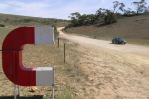
- Orroroo, South AustraliaOrroroo, South AustraliaOrroroo is a town in the Flinders Ranges region of South Australia. At the 2006 census, Orroroo had a population of 543. The Wilmington-Ucolta Road passes through here, intersecting there with the southern stretch of the Birdsville and Oodnadatta Tracks. The narrow gauge rail line was extended to...
: Magnetic Hill - Moonbi, New South WalesMoonbi, New South WalesMoonbi is a village situated on the New England Highway 20 kilometres north of Tamworth, New South Wales, Australia. It is nestled at the foot of the Moonbi Range and is part of the Tamworth Regional Council Local Government Area. Moonbi is located a few kilometres to the north of town of Kootingal...
, near TamworthTamworth, New South WalesTamworth is a city in the New England region of New South Wales, Australia. Straddling the Peel River, Tamworth, which contains an estimated population of 47,595 people, is the major regional centre for southern New England and in the local government area of Tamworth Regional Council. The city...
has a "Gravity Hill" near the Moonbi lookout. - Bowen Mountain, New South WalesBowen Mountain, New South WalesBowen Mountain is a small township in New South Wales, Australia, in the City of Hawkesbury. It is in the foothills of the Blue Mountains. The population of the town is 1,438 ....
: Bowen Mountain Road, shortly after turnoff from Grose Vale Road. Known as Magnetic Mountain. Hill starts at intersection of Bowen Mountain Road and Westbury Road.
Brazil
- Rua do Amendoim: Urban street in the city of Belo Horizonte, capital of the State of Minas Gerais. Street name is Portuguese for "Peanut Street".
Canada
- Moncton, New BrunswickMoncton, New BrunswickMoncton is a Canadian city, located in Westmorland County, New Brunswick. The city is situated in southeastern New Brunswick, within the Petitcodiac River Valley, and lies at the geographic centre of the Maritime Provinces...
: Magnetic Hill. - Burlington, OntarioBurlington, OntarioBurlington , is a city located in Halton Region at the western end of Lake Ontario. Burlington is part of the Greater Toronto Area, and is also included in the Hamilton Census Metropolitan Area. Physically, Burlington lies between the north shore of Lake Ontario and the Niagara Escarpment...
: King Road, just north of Bayview Park. Stop car at "No Motorized Vehicles" sign, face south. - Dacre, Ontario: Highway 41, near intersection with Highway 132, known as Magnetic Hill.
- Sparta, Ontario: Yarmouth Centre Road between Sparta Line (Hwy 27) and Fruit Ridge Line, facing south.
- Chartierville, QuebecChartierville, QuebecChartierville is a small village of 300 people in Le Haut-Saint-François Regional County Municipality, in Quebec, Canada.Chartierville is located Route 257 South. Prior to its founding in 1870 by colonists from Saint-Hyacinthe, gold-seekers flocked to the area...
: Magnetic Hill. - BridgetownBridgetown, Nova ScotiaBridgetown is a Canadian town in Annapolis County, Nova Scotia.Situated on the Annapolis River at the head of the tide, the area saw Mi'kmaq settlements in the area, followed by Acadian settlers from Port-Royal and then British-sponsored settlements by the late 18th century.There were at least ten...
, Nova ScotiaNova ScotiaNova Scotia is one of Canada's three Maritime provinces and is the most populous province in Atlantic Canada. The name of the province is Latin for "New Scotland," but "Nova Scotia" is the recognized, English-language name of the province. The provincial capital is Halifax. Nova Scotia is the...
: on Hampton Mountain Road 1 km (0.621372736649807 mi) north of Valleyview Provincial Park.
China
- GansuGansu' is a province located in the northwest of the People's Republic of China.It lies between the Tibetan and Huangtu plateaus, and borders Mongolia, Inner Mongolia, and Ningxia to the north, Xinjiang and Qinghai to the west, Sichuan to the south, and Shaanxi to the east...
: a 200 ft (61 m) slope at an angle of 15 degrees in a desert region of Yugur County.
France
- A 300 m road, between La Loge des Gardes and RenaisonRenaisonRenaison is a commune in the Loire department in central France....
near the village Les Noës, known as route magique (magical road)
Guatemala
- Paso misterioso, on the road from Cocales, Suchitepequez to San Lucas TolimánSan Lucas TolimánSan Lucas Tolimán is a municipality in the Sololá department of Guatemala. The town of 17,000 people sits on the southeastern shore of Lago de Atitlán, described by Aldous Huxley as one of the most beautiful lakes in the world. The population is 90-95% Highland Maya...
, SololáSololáSololá is a city in Guatemala. It is the capital of the department of Sololá and the administrative seat of Sololá municipality.The name is a hispanicized form of its pre-Columbian name, one spelling variant of which is T'zolojy'a...
, about 130 km (81 mi) from the capital cityGuatemala CityGuatemala City , is the capital and largest city of the Republic of Guatemala and Central America...
India
- LadakhLadakhLadakh is a region of Jammu and Kashmir, the northernmost state of the Republic of India. It lies between the Kunlun mountain range in the north and the main Great Himalayas to the south, inhabited by people of Indo-Aryan and Tibetan descent...
: Magnetic HillMagnetic Hill (India)Magnetic Hill is a gravity hill located near Leh in Ladakh, India. The hill is alleged to have magnetic properties strong enough to pull cars uphill and force passing aircraft to increase their altitude in order to escape magnetic interference...
in Leh.
Ireland
- County LouthCounty LouthCounty Louth is a county of Ireland. It is part of the Border Region and is also located in the province of Leinster. It is named after the town of Louth. Louth County Council is the local authority for the county...
: Cooley peninsulaCooley peninsulaThe Cooley Peninsula is a hilly peninsula in County Louth, Ireland, which includes towns such as Omeath, Carlingford and Greenore.-Geography:...
, north of DundalkDundalkDundalk is the county town of County Louth in Ireland. It is situated where the Castletown River flows into Dundalk Bay. The town is close to the border with Northern Ireland and equi-distant from Dublin and Belfast. The town's name, which was historically written as Dundalgan, has associations...
. Known locally as Magic Hill. - County WaterfordCounty Waterford*Abbeyside, Affane, Aglish, Annestown, An Rinn, Ardmore*Ballinacourty, Ballinameela, Ballinamult, Ballinroad, Ballybeg, Ballybricken, Ballyduff Lower, Ballyduff Upper, Ballydurn, Ballygunner, Ballylaneen, Ballymacarbry, Ballymacart, Ballynaneashagh, Ballysaggart, Ballytruckle, Bilberry, Bunmahon,...
: Comeragh MountainsComeragh MountainsThe Comeragh Mountains are a glaciated mountain range situated in the south east of Ireland in County Waterford. They are located between the town of Clonmel on the County Tipperary border and the villages of Kilrossanty and Kilmacthomas in County Waterford.The twelve mountains which form the...
, on the road to the Mahon FallsRiver MahonThe River Mahon flows from the Comeragh Mountains in County Waterford, Ireland.Falling down the 80-metre Mahon Falls and proceeding past the "Fairy Bush", the river then passes through the village of Mahon Bridge and on past Flahavan's Mill and under the 8-arched rail bridge in Kilmacthomas...
.
Italy
- Rome (Lazio) - Between Albano and Nemi lakes, called 'Ariccia's downhill'. Coming from Rocca di Papa (little town near Rome), driving forward Ariccia direction, acrossing "via dei laghi" you'll get on the ss218, after 100 meeters you are on the "magic downhill".
- Downhill near Roccabruna (PiedmontPiedmontPiedmont is one of the 20 regions of Italy. It has an area of 25,402 square kilometres and a population of about 4.4 million. The capital of Piedmont is Turin. The main local language is Piedmontese. Occitan is also spoken by a minority in the Occitan Valleys situated in the Provinces of...
). - The “mirage” slope in Montagnaga
Romania
- In the county of Maramureş, the road between Budeşti and Cavnic. The co-ordinates are 47,70469 N, 23,91786 E.
South Africa
- Between Greytown, KwaZulu-NatalGreytown, KwaZulu-NatalGreytown is a town situated on the banks of a tributary of the Umvoti River in a richly fertile timber-producing area of KwaZulu-Natal, South Africa.-History:...
and Weenen, KwaZulu-NatalWeenen, KwaZulu-NatalWeenen is the second oldest European settlement in KwaZulu-Natal, South Africa. It is situated on the banks of the Bushman River. The farms around the town grow vegetables, lucerne, groundnuts, and citrus fruit. The town was laid out in 1838 at the site of a massacre by the Zulus following...
. - Cape Town: Parel Vallei road, Parel Vallei, Somerset West. At the end/top of the straight road about 100m from the curve where a farm's entrance is located, it will look downhill but your vehicle will roll backwards / "uphill".
United Kingdom
England
- BuckinghamshireBuckinghamshireBuckinghamshire is a ceremonial and non-metropolitan home county in South East England. The county town is Aylesbury, the largest town in the ceremonial county is Milton Keynes and largest town in the non-metropolitan county is High Wycombe....
: Aston ClintonAston ClintonAston Clinton is a village and civil parish close to the main A41 road in Buckinghamshire, England between Tring and Aylesbury. The parish covers and is about east of Aylesbury. The village is at the foot of the chalk escarpment of the Chiltern Hills at the junction of the pre-historic track the...
, on Dancer's End Lane, off the B4009. GPS Coordinates : N 51° 47.184 W 000° 41.646 - EssexEssexEssex is a ceremonial and non-metropolitan county in the East region of England, and one of the home counties. It is located to the northeast of Greater London. It borders with Cambridgeshire and Suffolk to the north, Hertfordshire to the west, Kent to the South and London to the south west...
: Hangman's Hill, High Beech, Epping ForestEpping ForestEpping Forest is an area of ancient woodland in south-east England, straddling the border between north-east Greater London and Essex. It is a former royal forest, and is managed by the City of London Corporation....
. - West SussexWest SussexWest Sussex is a county in the south of England, bordering onto East Sussex , Hampshire and Surrey. The county of Sussex has been divided into East and West since the 12th century, and obtained separate county councils in 1888, but it remained a single ceremonial county until 1974 and the coming...
: RogateRogateRogate is a village and civil parish in the Chichester district of West Sussex, England situated in the Western Rother valley. The village is on the A272 road seven miles west of Midhurst. The parish comprises the villages of Rogate and Rake and the hamlets of Haben, Fyning, Hill Brow, Langley,...
, on the A272 roadA272 roadThe A272 is a road in South-East England. It follows an approximate East-West route from near Heathfield, East Sussex to the city of Winchester, Hampshire. It has achieved somewhat unlikely fame in recent years by being the subject of a book by the Dutch author, Pieter Boogaart...
to the west of the village.
Northern Ireland
- County DownCounty Down-Cities:*Belfast *Newry -Large towns:*Dundonald*Newtownards*Bangor-Medium towns:...
: Mourne Mountains, on the B27 head south east towards the Spelga Dam.
California
- Placer CountyPlacer County, CaliforniaPlacer County is a county located in both the Sacramento Valley and Sierra Nevada regions of the U.S. state of California, in what is known as the Gold Country. It stretches from the suburbs of Sacramento to Lake Tahoe and the Nevada border. Because of the expansion of the Greater Sacramento,...
: Highway 20 about 4 miles west of the Interstate 80 junction. A Pacific Gas & Electric company canal crosses under the highway and appears to westbound travelers to flow uphill to the left - DevoreDevore, CaliforniaDevore is a neighborhood in the city of San Bernardino, California. It is located near the northern junction of Interstate 15 and Interstate 215. The area is just outside the boundaries of the San Bernardino National Forest; nearby cities/town centers include Universitytown, Fontana, and Rialto...
: On Glen Helen road pass two consecutive train tracks and end up at a stop sign. Make a U-Turn and head back towards the tracks, but stop the car at the beginning of a chain link fence on the left hand (driver) side. - WhittierWhittier, CaliforniaWhittier is a city in Los Angeles County, California about southeast of Los Angeles. The city had a population of 85,331 at the 2010 census, up from 83,680 as of the 2000 census, and encompasses 14.7 square miles . Like nearby Montebello, the city constitutes part of the Gateway Cities...
: Site at cemetery in Whittier, on Workman Mill Rd., near Rio Hondo Community College - San DiegoSan Diego, CaliforniaSan Diego is the eighth-largest city in the United States and second-largest city in California. The city is located on the coast of the Pacific Ocean in Southern California, immediately adjacent to the Mexican border. The birthplace of California, San Diego is known for its mild year-round...
: The exit ramp in Mira Mesa/Sorrento Valley while going 805-S is a gravity hill. Testers should be cautious, considering it is a freeway exit. - Santa CruzSanta Cruz, CaliforniaSanta Cruz is the county seat and largest city of Santa Cruz County, California in the US. As of the 2010 U.S. Census, Santa Cruz had a total population of 59,946...
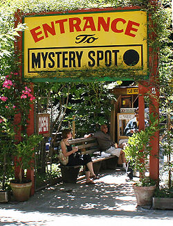
: Mystery SpotMystery SpotThe Mystery Spot is a tourist attraction located near Santa Cruz, California. It was discovered in 1939 and opened in 1940. The operators of the small site claim that it is a place where the laws of physics and gravity do not apply and provide a number of demonstrations in support of these...
at 465 Mystery Spot Road is a spot about 150 feet in diameter located in a redwood forest. - PetalumaPetaluma, CaliforniaPetaluma is a city in Sonoma County, California, in the United States. In the 2010 Census the population was 57,941.Located in Petaluma is the Rancho Petaluma Adobe, a National Historic Landmark. It was built beginning in 1836 by General Mariano Guadalupe Vallejo, then Commandant of the San...
: (Located in Sonoma County) From US 101 Freeway, take Rohnert Park Expressway east to Petaluma Hill Road. Petaluma Hill Road south to Roberts Road. Roberts road east to Lichau Road. At an iron gate with the words, "Gracias San Antonio," is the start of the gravity hill section (on the western slope of *Sonoma MountainSonoma MountainSonoma Mountain is a prominent landform within the Sonoma Mountains of southern Sonoma County, California. At elevation of , Sonoma Mountain offers expansive views of the Pacific Ocean to the west and the Sonoma Valley to the east...
near the Fairfield Osborn PreserveFairfield Osborn PreserveThe Fairfield Osborn Preserve is a 411 acre nature reserve situated on the northwest flank of Sonoma Mountain in Sonoma County, California. There are eight plant communities within the property, oak woodland being the dominant type...
). - Oak Glen: A magnetic hill is founded 10 miles or so down Oak Glen Road passed Riley's Farm. The hill is located two turns passed Riley's.
Florida
- Lake WalesLake Wales, FloridaLake Wales is a city in Polk County, Florida, United States. The population was 10,194 at the 2000 census. As of 2004, the population recorded by the U.S. Census Bureau is 11,802 . It is part of the Lakeland–Winter Haven Metropolitan Statistical Area...
: Spook HillSpook HillSpook Hill is a gravity hill in Lake Wales, Florida.Spook Hill is located on the Lake Wales Ridge, a geologically significant range of sand and limestone hills, which were islands from two to three million years ago, when sea levels were much higher than at present...
, Hwy 27U.S. Route 27U.S. Route 27 is a north–south United States highway in the southern and midwestern United States. The southern terminus is at US 1 in Miami, Florida. The northern terminus is at Interstate 69 in Fort Wayne, Indiana...
between OrlandoOrlando, FloridaOrlando is a city in the central region of the U.S. state of Florida. It is the county seat of Orange County, and the center of the Greater Orlando metropolitan area. According to the 2010 US Census, the city had a population of 238,300, making Orlando the 79th largest city in the United States...
and TampaTampa, FloridaTampa is a city in the U.S. state of Florida. It serves as the county seat for Hillsborough County. Tampa is located on the west coast of Florida. The population of Tampa in 2010 was 335,709....
.
Georgia
- CummingCumming, GeorgiaCumming is a city in Forsyth County, Georgia, United States. The population was 5,430 at the 2010 census. However, places with a Cumming mailing address have a population of around 100,000...
: Booger Hill a.k.a. Booger Mountain. - ManchesterManchester, GeorgiaManchester is a city located in Meriwether and Talbot Counties in the U.S. state of Georgia, although primarily in Meriwether. The population was 3,769 at the 2010 census.-Demographics:...
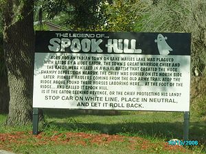
: about 1 mile south of town is Magic Hill. Once a tourist attraction, now on private land. - Fort GainesFort Gaines, GeorgiaFort Gaines is a city in Clay County, Georgia, United States. The population was 1,110 at the 2000 census. The city is the county seat of Clay County.-Geography:Fort Gaines is located at ....
: Spook Hill, north of town.
Indiana
- MooresvilleMooresville, IndianaMooresville is a town in Brown Township, Morgan County, Indiana, in the United States. As of the 2010 census, the town population was 9,326. It was founded in 1824 by Samuel Moore, a Quaker from North Carolina.-Geography:Mooresville is located at ....
: Head west out of town on High Street (2 blocks South of Main), which becomes State Road 42. Take the first right onto Keller Hill Road, and go approximately 1 mile over a few small hills. Stop at the big hill, there is a silo right before arrival at Gravity Hill. Line up the front with the large old tree on the right.
Kentucky
- PrincetonPrinceton, KentuckyPrinceton is a city in Caldwell County, Kentucky, United States. The population was 6,329 at the 2010 census. It is the county seat of Caldwell County.-History:...
: about one mile west of Princeton is a gravity hill on a side road to the right. - CovingtonCovington, Kentucky-Demographics:As of the census of 2000, there were 43,370 people, 18,257 households, and 10,132 families residing in the city. The population density was 3,301.3 people per square mile . There were 20,448 housing units at an average density of 1,556.5 per square mile...
: in Devou Park.
Massachusetts
- GreenfieldGreenfield, MassachusettsGreenfield is a city in Franklin County, Massachusetts, United States. The population was 17,456 at the 2010 census. It is the county seat of Franklin County. Greenfield is home to Greenfield Community College, the Pioneer Valley Symphony Orchestra, and the Franklin County Fair...
: Shelburne Road facing towards Greenfield immediately after the Route 2 overpass. - HarvardHarvard, MassachusettsHarvard is a town in Worcester County, Massachusetts, United States. A farming community settled in 1658 and incorporated in 1732, it has been home to several non-traditional communities, such as Harvard Shaker Village and the utopian Transcendentalist center Fruitlands...
Michigan
- Blaine TownshipBlaine Township, MichiganBlaine Township is a civil township of Benzie County in the U.S. state of Michigan. As of the 2000 census, the township population was 491. It is located in the southwest portion of the county. There are no significant population centers in the township; the nearest towns are Arcadia to the south,...
(near ArcadiaArcadia Township, Manistee County, MichiganArcadia Township is a civil township of Manistee County in the U.S. state of Michigan. As of the 2000 census, the township population was 621....
): Putney Road south of its intersection with Joyfield Road. - Rose CityRose City, MichiganRose City is a city in Ogemaw County in the U.S. state of Michigan. The population was 653 at the 2010 census. Houghton Creek, a tributary of the Rifle River, runs through part of the city limits.-Geography:...
: at the end of Reasner Road, past Heath Road.
Missouri
- FreemanFreeman, MissouriFreeman is a city in Cass County, Missouri, United States. The population was 521 at the 2000 census.-Geography:Freeman is located at .According to the United States Census Bureau, the city has a total area of , all of it land....
: southwest of town near the Kansas border at the intersection of State Highway D and East 299th St. Just outside of Louisburg, KansasLouisburg, KansasLouisburg is a city in Miami County, Kansas, United States. As of the 2010 census, the city population was 4,315.-19th century:Prior to the American Civil War, the land of what is now called Louisburg was part of that reserved for members of various tribes of Native Americans that were ceding...
.
New Jersey
- TitusvilleTitusville, New JerseyTitusville is an unincorporated area located within Hopewell Township, in Mercer County, New Jersey, United States. The area includes a post office with its own ZIP code , a small village of homes, and a large park dedicated to George Washington's crossing of the Delaware River in...
: Pleasant Valley Road. - Jackson: Farmingdale Road and New Prospect Road.
- Franklin LakesFranklin Lakes, New JerseyFranklin Lakes is a borough in Bergen County, New Jersey, United States. As of the 2010 census, the borough population was 10,590. As of the 2000 Census, Franklin Lakes had the 18th-highest per-capita income of all 566 municipalities in the state. Nationwide, Franklin Lakes ranked 17th among the...
: Ewing Avenue exit of Rt. 208 South.
Oklahoma
- BartlesvilleBartlesville, OklahomaBartlesville is a city in Osage and Washington counties in the U.S. state of Oklahoma. The population was 43,070 at the 2010 census. Bartlesville is located forty-seven miles north of Tulsa and very close to Oklahoma's northern border with Kansas. It is the county seat of Washington County, in...
: East on 2400 road to N3940 Road. Face east at the first white fencepost near the corner on 2400 Road.
Pennsylvania
- Buckingham TownshipBuckingham Township, Bucks County, PennsylvaniaBuckingham Township is a township in Bucks County, Pennsylvania, United States. The population was 20,075 at the 2010 census. Buckingham takes its name from Buckingham in Buckinghamshire known as Bucks County in England...
: a quarter mile from the Mount Gilead African Methodist Episcopal Church. More specifically, Holicong Road heading south just before Buckingham Mountain. - New ParisNew Paris, PennsylvaniaNew Paris is a borough in Bedford County, Pennsylvania, United States. The population was 214 at the 2000 census. New Paris is located northwest of Bedford, north of Schellsburg and ENE of Somerset.-History:...
: Gravity Hill Road (two gravity hills in this area). - Near UniontownUniontown, PennsylvaniaUniontown is a city in Fayette County, Pennsylvania, southeast of Pittsburgh and part of the Pittsburgh Metro Area. Population in 1900, 7,344; in 1910, 13,344; in 1920, 15,692; and in 1940, 21,819. The population was 10,372 at the 2010 census...
: Laurel CavernsLaurel CavernsLaurel Caverns, formerly known as Dulaney's Cave and Laurel Hill Cave, is the largest cave in Pennsylvania. Located in Farmington, Pennsylvania; it sits on Chestnut Ridge near Uniontown, about southeast of Pittsburgh....
. - Near LewisberryLewisberry, PennsylvaniaLewisberry is a borough in York County, Pennsylvania, United States. The population was 362 at the 2010 census.-Geography:Lewisberry is located at ....
, York CountyYork County, PennsylvaniaYork County is a county in the U.S. state of Pennsylvania. As of 2010, the population was 434,972. It is in the Susquehanna Valley, a large fertile agricultural region in South Central Pennsylvania....
, on Pleasantview Road (also rendered Pleasant View Road) at State Route 177Pennsylvania Route 177Pennsylvania Route 177 is an long state highway located in York county in Pennsylvania. The southern terminus is an intersection with PA 74 and Township Route 4026 in Rossville. From this intersection, PA 177 bisects the southwestern portion of Pinchot Lake and continues along the northwestern...
.
South Dakota
- Rapid CityRapid City, South DakotaRapid City is the second-largest city in the U.S. state of South Dakota, and the county seat of Pennington County. Named after Rapid Creek on which the city is established, it is set against the eastern slope of the Black Hills mountain range. The population was 67,956 as of the 2010 Census. Rapid...
: Cosmos Mystery Area, 16 miles South of Rapid City on Hwy 16, 6 miles from Mount Rushmore.
Texas
- El PasoEl Paso, TexasEl Paso, is a city in and the county seat of El Paso County, Texas, United States, and lies in far West Texas. In the 2010 census, the city had a population of 649,121. It is the sixth largest city in Texas and the 19th largest city in the United States...
: Thunderbird Drive facing south. - San Antonio: Just east of the San Antonio Missions National Historic Park at the railway crossing at Villamain Road and Shane Road
Utah
- Salt Lake City: A few blocks northeast of the Capitol building in Salt Lake City. Driving up past the capitol building, with the capitol to the driver's west, there is a small road (Bonneville Blvd.) that loops around a park in lower City Creek Canyon called Memory Grove. It appears that the car is going downhill while actually gaining in elevation from the valley floor.
Washington
- ProsserProsser, WashingtonProsser is a city in and the county seat of Benton County, Washington, United States, along the Yakima River with only one zip code 99350. The population was 5,714 at the 2010 census.-History:...
: Near a small farm on North Crosby Road, approximately 10 miles northeast of Prosser. Set vehicle into neutral at the word "start" that is written across the surface of the road and car will start rolling "uphill."
Wisconsin
- Lake DeltonLake Delton, WisconsinLake Delton is a village located on the Wisconsin River in Sauk County, Wisconsin, United States. As of the 2000 census, the village had a total population of 1,982, but in 2009, it had an estimated population of 3,081 which is a 55.4% increase. It also makes it the largest community in the Dells...
: Wonder Spot (being torn down and replaced by a highway). - StockbridgeStockbridge, WisconsinStockbridge is a village in Calumet County, Wisconsin, United States. The population was 649 in the 2000 census. The village lies within the Town of Stockbridge.-History:...
: Joe Road, 3 mi (5 km) south of Stockbridge west off STH 55. - ShullsburgShullsburg, WisconsinShullsburg is a city in Lafayette County, Wisconsin, United States. The population was 1,246 at the 2000 census. The city is located within the Town of Shullsburg.-Geography:...
: Judgement Street, just after Rennick Road.