
Moonbi, New South Wales
Encyclopedia
Moonbi is a village situated on the New England Highway
20 kilometres north of Tamworth, New South Wales
, Australia
. It is nestled at the foot of the Moonbi Range
and is part of the Tamworth Regional Council
Local Government Area
. Moonbi is located a few kilometres to the north of town of Kootingal
. At the 2006 census
, Moonbi had a population of 357 people.
The village is renowned as a centre for the poultry
industry with many large poultry farms and associated industries located around the area. Moonbi has erected a large fibreglass chicken in recognition of the poultry industry centered here. The surrounding area has many small 'lifestyle' blocks that are often used to run horses.
(or Gamilaraay) and Anaiwon Aboriginal
people.
William Dangar and Edward Cory crossed the ranges in 1830. "Cory's Pillar", also known as Cory's Nightcap, is a prominent balancing stone landmark seen on the right of the New England Highway when travelling northwards on the first Moonbi Hill.
A village was settled there in the 1850s when bullock teams and travellers began passing through the region in search of new land for their livestock
. During this period there were two inns and one hotel there. In 1859 a post office opened at Moonby Station and in 1882 the Moonbi Public School opened.
 In August 2007 Moonbi became the centre of attention in the wake of the quarantined horses and lockdown at Moonbi Recreation Ground as a result of the equine influenza outbreak. This followed the running of dressage
competitions here during the outbreak of EI. The situation was made difficult as no accommodation was available here for the horse owners.
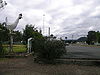
The village has a post office, public school, recreation ground, pony club grounds, general store, nursing home, produce retailer, roadhouse, service station and a rubber belting supplies and engineering company.
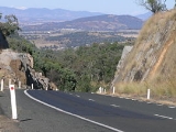
Travelling north along the New England Highway, on the first Moonbi Hill, is the Moonbi Lookout perched on a huge granite
outcrop with some beautiful views of Moonbi and the Cockburn Valley.
New England Highway
The New England Highway is a highway in Australia running from Hexham near Newcastle at its southern end to Yarraman near Toowoomba at its northern end. At its southern end it connects to the Pacific Highway and at its northern end it connects to the D'Aguilar Highway. It traverses the Hunter...
20 kilometres north of Tamworth, New South Wales
Tamworth, New South Wales
Tamworth is a city in the New England region of New South Wales, Australia. Straddling the Peel River, Tamworth, which contains an estimated population of 47,595 people, is the major regional centre for southern New England and in the local government area of Tamworth Regional Council. The city...
, Australia
Australia
Australia , officially the Commonwealth of Australia, is a country in the Southern Hemisphere comprising the mainland of the Australian continent, the island of Tasmania, and numerous smaller islands in the Indian and Pacific Oceans. It is the world's sixth-largest country by total area...
. It is nestled at the foot of the Moonbi Range
Moonbi Range
The Moonbi Range is a chain of hills which forms a part of the Northern Tablelands, New South Wales, Australia.The range is located roughly 20 kilometres north east of the city of Tamworth situated at the bottom of the Wentworth Mounds, which is part of the Moonbi Range. These mounds form a spur of...
and is part of the Tamworth Regional Council
Tamworth Regional Council
Tamworth Regional Council is a Local Government Area in the New England region of New South Wales, Australia. It is on the New England Highway and the Main North railway line.- Incomes :According to the during 2003-04, there:...
Local Government Area
Local Government Area
A local government area is an administrative division of a country that a local government is responsible for. The size of an LGA varies by country but it is generally a subdivision of a state, province, division, or territory....
. Moonbi is located a few kilometres to the north of town of Kootingal
Kootingal, New South Wales
Kootingal is a town in New South Wales, Australia in the Tamworth Regional Council area. It is commonly called a satellite suburb of Tamworth because of its closeness and the fact that its residents use Tamworth's services. Founded as an Aboriginal mission, Kootingal traces its name roots to the...
. At the 2006 census
Census in Australia
The Australian census is administered once every five years by the Australian Bureau of Statistics. The most recent census was conducted on 9 August 2011; the next will be conducted in 2016. Prior to the introduction of regular censuses in 1961, they had also been run in 1901, 1911, 1921, 1933,...
, Moonbi had a population of 357 people.
The village is renowned as a centre for the poultry
Poultry
Poultry are domesticated birds kept by humans for the purpose of producing eggs, meat, and/or feathers. These most typically are members of the superorder Galloanserae , especially the order Galliformes and the family Anatidae , commonly known as "waterfowl"...
industry with many large poultry farms and associated industries located around the area. Moonbi has erected a large fibreglass chicken in recognition of the poultry industry centered here. The surrounding area has many small 'lifestyle' blocks that are often used to run horses.
History
The Moonbi area is the traditional land of the KamilaroiKamilaroi
The Kamilaroi or Gamilaraay are an Indigenous Australian people who are from the area between Tamworth and Goondiwindi, and west to Narrabri, Walgett and Lightning Ridge, in northern New South Wales...
(or Gamilaraay) and Anaiwon Aboriginal
Australian Aborigines
Australian Aborigines , also called Aboriginal Australians, from the latin ab originem , are people who are indigenous to most of the Australian continentthat is, to mainland Australia and the island of Tasmania...
people.
William Dangar and Edward Cory crossed the ranges in 1830. "Cory's Pillar", also known as Cory's Nightcap, is a prominent balancing stone landmark seen on the right of the New England Highway when travelling northwards on the first Moonbi Hill.
A village was settled there in the 1850s when bullock teams and travellers began passing through the region in search of new land for their livestock
Livestock
Livestock refers to one or more domesticated animals raised in an agricultural setting to produce commodities such as food, fiber and labor. The term "livestock" as used in this article does not include poultry or farmed fish; however the inclusion of these, especially poultry, within the meaning...
. During this period there were two inns and one hotel there. In 1859 a post office opened at Moonby Station and in 1882 the Moonbi Public School opened.
Dressage
Dressage is a competitive equestrian sport, defined by the International Equestrian Federation as "the highest expression of horse training." Competitions are held at all levels from amateur to the World Equestrian Games...
competitions here during the outbreak of EI. The situation was made difficult as no accommodation was available here for the horse owners.
The village has a post office, public school, recreation ground, pony club grounds, general store, nursing home, produce retailer, roadhouse, service station and a rubber belting supplies and engineering company.
Travelling north along the New England Highway, on the first Moonbi Hill, is the Moonbi Lookout perched on a huge granite
Granite
Granite is a common and widely occurring type of intrusive, felsic, igneous rock. Granite usually has a medium- to coarse-grained texture. Occasionally some individual crystals are larger than the groundmass, in which case the texture is known as porphyritic. A granitic rock with a porphyritic...
outcrop with some beautiful views of Moonbi and the Cockburn Valley.
External links
- Kootingal-Moonbi General Cemetery: http://cemindex.arkangles.com/cemetery.php?id=212