
Oregon Route 569
Encyclopedia
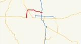
Oregon Route 569 is an Oregon
state highway
serving as an outer quarter-loop in Eugene
and Springfield
. OR 569 comprises part of the Beltline Highway No. 69 (see Oregon highways and routes). It is 9.9 miles (15.9 km) long and runs east–west. OR 569 is not a complete beltway, though it was originally proposed as such before freeway revolt
s resulted in the original plan being scrapped.
In March, 2010, the Oregon Transportation Commission voted to rename the highway from Beltline to Randy Papé Beltway. This name change met much opposition. (See History below.) By April, it was finalized as the Randy Papé Beltline.
 OR 569 begins at a T-intersection with OR 126, on the western edge of Eugene. At first, as it heads north and east, it is an expressway
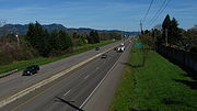
, with one at-grade signalized intersection. Soon it becomes a two lane freeway in each direction, as it crosses the northern edge of incorporated Eugene. From the highway, one sees mostly suburban housing and strip malls. At the eastern end, there is an interchange
with I-5
. Beltline becomes a local road at Gateway Street. The roadway continues, eventually reaching OR 528
in Springfield.
One other section of the initial proposal was built. This section is the stretch of 30th Avenue between the Amazon Park neighborhood and Lane Community College
--a four-lane expressway
which includes two interchanges. This route does not connect directly to the existing stretch of Belt Line Road.
Several enhancements to the Beltline Road have been proposed. The West Eugene Parkway, had it been built, would have intersected Beltline Road at a new interchange. Plans are underway to upgrade the interchange with the Delta Highway
. The I-5 interchange was upgraded in 2008. The latter interchange was a full cloverleaf
design, and was considered to be both obsolete and dangerous. To upgrade the interchange, a flyover bridge was built, eliminating the northeastern loop ramp and the weaving movements on northbound Interstate 5 and westbound Beltline Road. Construction is underway to redesign the nearby intersection with Gateway Boulevard.
would have been an issue, and the Oregon Department of Transportation
wanted to sign the route to make navigation easier during the 2008 U.S. Olympic Trials
, so ODOT requested that the Oregon Transportation Commission change the number to 14. At their January 25, 2007 meeting, the OTC decided to instead call the highway Route 569, which kept with the pattern used in other cases where the highway number could not be used (usually because there was already a route with that number). Signs for Route 569 were posted by August 2007.
requested that Beltline Highway be renamed for local businessman and civic leader Randy Papé. On March 11, the Oregon Transportation Commission approved renaming it to the Randy Papé Beltway. This caused a huge uproar against the decision: there was little chance for any citizen feedback, and if the plan went through around $250,000 would have been spent on sign changes. On April 13, 2010, the Lane County Board of Commissioners voted unanimously to request a suspension of any plans to rename the highway. The Oregon Transportation Commission, however, barely budged, and on April 21 settled on the name Randy Pape Beltline. Initially, to save money, only 2 signs, one at each end of the route, will be changed. Other signs will be replaced as they wear out. Opponents argued that while this proposal looks like a great deal on the surface, emails obtained from ODOT through public records request show that the renaming of the highway adds extra letters to the signs which translates into larger signs which may also require larger supports. ODOT estimated that instead of the original cost of $250,000 to replace the 53 signs that the new estimate could reach over $500,000. Opponents sought to reverse the name change and had a bit more than 1000 signatures by placing a measure on the November 2010 ballot that would require state-wide voter approval to rename state-owned property but fell more than 80,000 signatures short, having had only a few days to collect them. There may be another attempt in 2012.
Oregon
Oregon is a state in the Pacific Northwest region of the United States. It is located on the Pacific coast, with Washington to the north, California to the south, Nevada on the southeast and Idaho to the east. The Columbia and Snake rivers delineate much of Oregon's northern and eastern...
state highway
State highway
State highway, state road or state route can refer to one of three related concepts, two of them related to a state or provincial government in a country that is divided into states or provinces :#A...
serving as an outer quarter-loop in Eugene
Eugene, Oregon
Eugene is the second largest city in the U.S. state of Oregon and the seat of Lane County. It is located at the south end of the Willamette Valley, at the confluence of the McKenzie and Willamette rivers, about east of the Oregon Coast.As of the 2010 U.S...
and Springfield
Springfield, Oregon
Springfield is a city in Lane County, Oregon, United States. Located in the Southern Willamette Valley, it is within the Eugene-Springfield Metropolitan Statistical Area. Separated from Eugene to the west, mainly by Interstate 5, Springfield is the second-most populous city in the metropolitan area...
. OR 569 comprises part of the Beltline Highway No. 69 (see Oregon highways and routes). It is 9.9 miles (15.9 km) long and runs east–west. OR 569 is not a complete beltway, though it was originally proposed as such before freeway revolt
Freeway and expressway revolts
Many freeway revolts took place in developed countries during the 1960s and 1970s, in response to plans for the construction of new freeways, a significant number of which were abandoned or significantly scaled back due to widespread public opposition; especially of those whose neighborhoods would...
s resulted in the original plan being scrapped.
In March, 2010, the Oregon Transportation Commission voted to rename the highway from Beltline to Randy Papé Beltway. This name change met much opposition. (See History below.) By April, it was finalized as the Randy Papé Beltline.
Route description
Limited-access road
A limited-access road known by various terms worldwide, including limited-access highway, dual-carriageway and expressway, is a highway or arterial road for high-speed traffic which has many or most characteristics of a controlled-access highway , including limited or no access to adjacent...
, with one at-grade signalized intersection. Soon it becomes a two lane freeway in each direction, as it crosses the northern edge of incorporated Eugene. From the highway, one sees mostly suburban housing and strip malls. At the eastern end, there is an interchange
Interchange (road)
In the field of road transport, an interchange is a road junction that typically uses grade separation, and one or more ramps, to permit traffic on at least one highway to pass through the junction without directly crossing any other traffic stream. It differs from a standard intersection, at which...
with I-5
Interstate 5 in Oregon
In the U.S. state of Oregon, Interstate 5 traverses the state from north to south, passing through the major cities of Portland, Salem, Eugene, and Medford.-Route description:...
. Beltline becomes a local road at Gateway Street. The roadway continues, eventually reaching OR 528
Oregon Route 528
Oregon Route 528 is an Oregon state highway running from OR 126 in Springfield to OR 126 Business in Springfield. OR 126 is known as the Springfield Highway No. 228...
in Springfield.
One other section of the initial proposal was built. This section is the stretch of 30th Avenue between the Amazon Park neighborhood and Lane Community College
Lane Community College
Lane Community College is a two-year college located in Eugene, Oregon. Its slogan is "Transforming Lives Through Learning."-Education:Lane Community College offers a variety of Associate's Degrees, such as:...
--a four-lane expressway
Limited-access road
A limited-access road known by various terms worldwide, including limited-access highway, dual-carriageway and expressway, is a highway or arterial road for high-speed traffic which has many or most characteristics of a controlled-access highway , including limited or no access to adjacent...
which includes two interchanges. This route does not connect directly to the existing stretch of Belt Line Road.
Several enhancements to the Beltline Road have been proposed. The West Eugene Parkway, had it been built, would have intersected Beltline Road at a new interchange. Plans are underway to upgrade the interchange with the Delta Highway
Delta Highway
Delta Highway is a short limited-access freeway in Eugene, Oregon, United States, linking downtown Eugene with Beltline Highway, northern Eugene and the Riverridge golf course to the north.-Route description:...
. The I-5 interchange was upgraded in 2008. The latter interchange was a full cloverleaf
Cloverleaf interchange
A cloverleaf interchange is a two-level interchange in which left turns, reverse direction in left-driving regions, are handled by ramp roads...
design, and was considered to be both obsolete and dangerous. To upgrade the interchange, a flyover bridge was built, eliminating the northeastern loop ramp and the weaving movements on northbound Interstate 5 and westbound Beltline Road. Construction is underway to redesign the nearby intersection with Gateway Boulevard.
History
The Beltline Highway was constructed by Lane County in the 1960s and transferred to state control in 1978 as Highway 69. The highway was assigned the Route 69 designation effective September 19, 2002. However, due to the sexual connotation of the number 69, sign theftStreet sign theft
Street sign theft occurs when street signs are stolen, often to be used as decorations, but also sometimes to avoid obeying the law by claiming later the sign was not there. Although the theft often seems arbitrary, signs that are unusual or amusing tend to be stolen more frequently...
would have been an issue, and the Oregon Department of Transportation
Oregon Department of Transportation
The Oregon Department of Transportation is a department of the state government of the U.S. state of Oregon responsible for systems of transportation. It was first established in 1969. It had been preceded by the Oregon State Highway Department which, along with the Oregon State Highway...
wanted to sign the route to make navigation easier during the 2008 U.S. Olympic Trials
United States Olympic Trials (track and field)
The United States Olympic Trials for the sport of Track and Field is the quadrennial meet to select the United States representatives at the Olympic Games. Since 1992, the meet has also served as the USA Outdoor Track and Field Championships. Because of the depth of competition in some events,...
, so ODOT requested that the Oregon Transportation Commission change the number to 14. At their January 25, 2007 meeting, the OTC decided to instead call the highway Route 569, which kept with the pattern used in other cases where the highway number could not be used (usually because there was already a route with that number). Signs for Route 569 were posted by August 2007.
Controversy with renaming Beltline
In early 2010, Oregon governor Ted KulongoskiTed Kulongoski
Theodore R. "Ted" Kulongoski is an American politician, who served as the 36th Governor of Oregon. A Democrat, he has served in both houses of the Oregon Legislative Assembly, as the state Insurance Commissioner, the Attorney General, and an Associate Justice on the Oregon Supreme Court.-Early...
requested that Beltline Highway be renamed for local businessman and civic leader Randy Papé. On March 11, the Oregon Transportation Commission approved renaming it to the Randy Papé Beltway. This caused a huge uproar against the decision: there was little chance for any citizen feedback, and if the plan went through around $250,000 would have been spent on sign changes. On April 13, 2010, the Lane County Board of Commissioners voted unanimously to request a suspension of any plans to rename the highway. The Oregon Transportation Commission, however, barely budged, and on April 21 settled on the name Randy Pape Beltline. Initially, to save money, only 2 signs, one at each end of the route, will be changed. Other signs will be replaced as they wear out. Opponents argued that while this proposal looks like a great deal on the surface, emails obtained from ODOT through public records request show that the renaming of the highway adds extra letters to the signs which translates into larger signs which may also require larger supports. ODOT estimated that instead of the original cost of $250,000 to replace the 53 signs that the new estimate could reach over $500,000. Opponents sought to reverse the name change and had a bit more than 1000 signatures by placing a measure on the November 2010 ballot that would require state-wide voter approval to rename state-owned property but fell more than 80,000 signatures short, having had only a few days to collect them. There may be another attempt in 2012.
Exit list
The entire route is in Lane County.| Location | Mile | # Exit number An exit number is a number assigned to a road junction, usually an exit from a freeway. It is usually marked on the same sign as the destinations of the exit, as well as a sign in the gore.... |
Destinations | Notes |
|---|---|---|---|---|
| Eugene Eugene, Oregon Eugene is the second largest city in the U.S. state of Oregon and the seat of Lane County. It is located at the south end of the Willamette Valley, at the confluence of the McKenzie and Willamette rivers, about east of the Oregon Coast.As of the 2010 U.S... |
3.10 | At-grade | ||
| 4.24 | Roosevelt Boulevard | At-grade | ||
| 5.62 | 5 | Barger Drive | ||
| 6.58 | 6 | |||
| 6.83 | 7A | Prairie Road | Westbound exit and eastbound entrance | |
| 7.09 | 7 | Northwest Expressway | ||
| 8.47 | 8 | River Road - Santa Clara | ||
| 9.56 | River Avenue, Division Avenue | No westbound entrance | ||
| 10.05 | Delta Highway Delta Highway Delta Highway is a short limited-access freeway in Eugene, Oregon, United States, linking downtown Eugene with Beltline Highway, northern Eugene and the Riverridge golf course to the north.-Route description:... , Ayres Road - Valley River Center Valley River Center Valley River Center is a super-regional-class shopping mall located in Eugene, Oregon, U.S. It is the largest shopping center between the Portland and San Francisco area with over 130 local and national stores and restaurants.... , Downtown Eugene |
|||
| 11.66 | Coburg Road | |||
| 12.77-12.78 | ||||
| Springfield Springfield, Oregon Springfield is a city in Lane County, Oregon, United States. Located in the Southern Willamette Valley, it is within the Eugene-Springfield Metropolitan Statistical Area. Separated from Eugene to the west, mainly by Interstate 5, Springfield is the second-most populous city in the metropolitan area... |
13.00 | Gateway Street | At-grade |