

List of Puerto Rico Highways
Encyclopedia
Highway
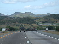
A highway is any public road. In American English, the term is common and almost always designates major roads. In British English, the term designates any road open to the public. Any interconnected set of highways can be variously referred to as a "highway system", a "highway network", or a...
system in Puerto Rico
Puerto Rico
Puerto Rico , officially the Commonwealth of Puerto Rico , is an unincorporated territory of the United States, located in the northeastern Caribbean, east of the Dominican Republic and west of both the United States Virgin Islands and the British Virgin Islands.Puerto Rico comprises an...
is divided into four networks: primary, urban primary, secondary or inter-municipal, and tertiary or local (Spanish: red primaria, primaria urbana, secundaria o intermunicipal, and terciaria o local, respectively). Highways may change between networks and retain their same numbers.
Route number shields
Puerto Rico roads are classified according to the network they belong to. Thus there are four types:- Primary Roads
- Urban Primary Roads
- Secondary (or inter-municipal) Roads
- Tertiary (or intra-municipal) Roads
In this regard a primary road is one which is part of the Primary Network, an urban primary road is part of the Urban Primary Network, etc. The same highway, such as the one leading from Ponce to San Juan, may change between networks, but the highway will continue to have the same number. Thus PR-1
Puerto Rico Highway 1
Puerto Rico Highway 1 connects the city of Ponce to San Juan. Leaving Ponce, the road follows somewhat parallel along the southern coast of the island and, at Salinas, it turns north to cut through the Cordillera Central in its approach to San Juan....
, one of the roads between Ponce and San Juan, is signed as Urban Primary inside the Ponce city limits, then it is signed as Secondary in Ponce's rural barrio Capitanejo
Capitanejo (Ponce)
Capitanejo is one of the 31 barrios of the municipality of Ponce, Puerto Rico. Along with Anón, Coto Laurel, Guaraguao, Quebrada Limón, Real, San Patricio, and Marueño, and the coastal barrio of Canas, Capitanejo is one of the municipality's nine bordering barrios. It borders the municipality of...
, and then it is again signed as Urban Primary on its entry into the town of Santa Isabel
Santa Isabel, Puerto Rico
Santa Isabel is a municipality of Puerto Rico located in the southern coast, south of Coamo; east of Juana Díaz; and west of Salinas. Santa Isabel is spread over 7 wards and Santa Isabel Pueblo...
.
Primary roads are numbered 1 through 99, secondary roads are numbered 100 to 299, and municipal (tertiary) roads are numbered 300 to 9999.
Until 1999, all non-tolled numbered highways in Puerto Rico had the same route shield, a square with a white-on-black half-circle with the route number in the bottom two thirds and a map of Puerto Rico with the words "Puerto Rico" written inside in the top third.
Road maintenance
All Puerto Rico roads, regardless of the network they belong to are maintained by the centralized, Commonwealth-level, Departmento de Transportacion y Obras PublicasPuerto Rico Department of Transportation and Public Works
The Puerto Rico Department of Transportation and Public Works is a government agency of Puerto Rico regulating transportation and public works. The agency's headquarters are located in San Juan.-External links:*...
(DTOP). Municipal governments are not responsible for maintenance of roads within their territory whether or not the municipal government is an autonomous government or not; DTOP is the responsible agency. The DTOP maintains a network of regional offices throughout the island which carry out DTOP work within their multi-municipality region. Municipal governments are only responsible for maintenance of city and town streets within their jurisdictions. On occasion, the central government has entered into MOA
Memorandum of Agreement
A memorandum of agreement or cooperative agreement is a document written between parties to cooperatively work together on an agreed upon project or meet an agreed objective. The purpose of an MOA is to have a written understanding of the agreement between parties.An MOA is a good tool to use for...
s with municipal governments for the collaborative maintenance of some state roadways within their municipalities.
Interstates
Puerto Rico has 410 km (254.8 mi) of Interstate highways. There are three designated Interstate Highways in Puerto Rico. As with Interstate Highways in AlaskaInterstate Highways in Alaska
There are four officially designated Interstate Highways in Alaska, even though the routes do not connect directly to any highways in the contiguous United States, except either by the Alaska Marine Highway System ferries or via Canadian highways....
and Hawaii
Interstate H-1
Interstate H-1 is the busiest Interstate Highway in Hawaii, United States, located on the island of O‘ahu. Despite the number, this is an east–west highway—the 'H'-series numbering reflects the order in which routes were funded and built. H-1 goes from Route 93 in Kapolei to Route 72 in...
, these routes do not connect to the United States
United States
The United States of America is a federal constitutional republic comprising fifty states and a federal district...
Interstate Highway system, but still receive funding in a similar fashion to the Interstates in the contiguous US.
Alaska
Alaska is the largest state in the United States by area. It is situated in the northwest extremity of the North American continent, with Canada to the east, the Arctic Ocean to the north, and the Pacific Ocean to the west and south, with Russia further west across the Bering Strait...
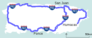
, Puerto Rico Interstate routes are unsigned. The designated routes of the three routes — officially PRI-1, PRI-2 and PRI-3 — run along various combinations of Puerto Rico routes. They do not follow the rules of even and odd numbers determining direction used in mainland United States. Per Section 103(c)(1)(B) (ii), Title 23, United States Code (23 U.S.C.) Puerto Rico is exempt from the design standards of Section 109(b).
Puerto Rico's interstate routes are not to be confused with Puerto Rico Routes PR-1
Puerto Rico Highway 1
Puerto Rico Highway 1 connects the city of Ponce to San Juan. Leaving Ponce, the road follows somewhat parallel along the southern coast of the island and, at Salinas, it turns north to cut through the Cordillera Central in its approach to San Juan....
, PR-2
Puerto Rico Highway 2
Puerto Rico Highway 2, the longest highway in the Commonwealth of Puerto Rico at about 156 miles long, connects San Juan to Ponce....
, and PR-3
Puerto Rico Highway 3
Puerto Rico Highway 3 ' at nearly 101 miles long, is the second longest highway on Puerto Rico . It connects the San Juan neighborhood of Rio Piedras to downtown Salinas indirectly around the eastern coast of the island...
. These are other major highways in Puerto Rico.
| Route | Component routes | Length mi |
Length km |
From | To |
|---|---|---|---|---|---|
| |
(PR 22/PR 18 interchange) | ||||
| |
(PR 1/PR 26 interchange) | ||||
| |
Roosevelt Roads Naval Air Station at Ceiba Ceiba, Puerto Rico Ceiba is a small town in northeast Puerto Rico. It is named after the famous Ceiba tree. Ceiba is located in the east coast of the island, bordering the Atlantic Ocean, north of Naguabo, south of Fajardo, and east of Río Grande. It is located about one hour's driving distance from San Juan... |
(PR 1/PR 26/PR 66 interchange) | |||
Autopistas
Autopistas in Puerto Rico are controlled-access highways, or expresswayLimited-access road
A limited-access road known by various terms worldwide, including limited-access highway, dual-carriageway and expressway, is a highway or arterial road for high-speed traffic which has many or most characteristics of a controlled-access highway , including limited or no access to adjacent...
s. Many, but not all, of them are tolled. All Puerto Rico Autopistas are signed either as primary or as primary urban routes. As of August, 2010, the current Autopistas were:
- PR-2Puerto Rico Highway 2Puerto Rico Highway 2, the longest highway in the Commonwealth of Puerto Rico at about 156 miles long, connects San Juan to Ponce....
- PR-5Puerto Rico Highway 5Puerto Rico Highway 5 is a main highway in the San Juan Metropolitan area which connects the cities of Cataño to Bayamón and is being extended and converted to a tollway to access the municipalities of Naranjito and Comerío. It is a short freeway from south Cataño to the business area in Bayamón...
(Tollway) - PR-18Puerto Rico Highway 18PR-18 is a freeway in Puerto Rico, which is also known as Expreso Las Américas. It runs from its north end in at its intersection with PR-22 in San Juan to its south end in Río Piedras where it intersects with PR-1. At this point PR-18 becomes PR-52, known as Autopista Luis A...
- PR-20Puerto Rico Highway 20Puerto Rico Highway 20 or PR-20 is a short freeway entirely located in Guaynabo, Puerto Rico. It used to be divided highway with traffic signals, which even turned into a rural road near its south end, but due to the traffic congestion in parallel freeway PR-18, and also in PR-1 and PR-52, it had...
(Tollway) - PR-22Puerto Rico Highway 22PR-22 is a 51-mile long toll road in the north coast of Puerto Rico that connects the cities of San Juan and Hatillo. The road is also known as the José de Diego Expressway , and is part of unsigned Interstate PR-2...
(Tollway) - PR-26
- PR-30Puerto Rico Highway 30Puerto Rico Highway 30, or PR-30 is a main freeway in Puerto Rico which connects the city of Caguas to the town of Humacao.-Exits:It is 30 kilometers long, and has several exits :CAGUAS...
- PR-52 (Tollway)
- PR-53Puerto Rico Highway 53Puerto Rico Highway 53 is a main tollway that is parallel to Puerto Rico Highway 3, which goes from Fajardo to Salinas. Some segments are still under construction, but when finished it will have about of length. Two tunnels, about 1 km long each, in the towns of Yabucoa and Maunabo were...
(Tollway) - PR-66Puerto Rico Highway 66Puerto Rico Highway 66 is a main tollway which parallels Puerto Rico Highway 3 going from the city of Carolina, Puerto Rico via a cloverleaf interchange with PR-26 and PR-3 and ending in the municipality of Canóvanas, Puerto Rico with an intersection of PR-3...
(Tollway, partially opened)
List of Highways
Below is a list of some highways in Puerto Rico along with the municipalities where they begin and end.Primary highways
| Number | South/West terminus | North/East terminus |
|---|---|---|
| Puerto Rico Highway 1 Puerto Rico Highway 1 Puerto Rico Highway 1 connects the city of Ponce to San Juan. Leaving Ponce, the road follows somewhat parallel along the southern coast of the island and, at Salinas, it turns north to cut through the Cordillera Central in its approach to San Juan.... |
Ponce Ponce, Puerto Rico Ponce is both a city and a municipality in the southern part of Puerto Rico. The city is the seat of the municipal government.The city of Ponce, the fourth most populated in Puerto Rico, and the most populated outside of the San Juan metropolitan area, is named for Juan Ponce de León y Loayza, the... |
San Juan San Juan, Puerto Rico San Juan , officially Municipio de la Ciudad Capital San Juan Bautista , is the capital and most populous municipality in Puerto Rico, an unincorporated territory of the United States. As of the 2010 census, it had a population of 395,326 making it the 46th-largest city under the jurisdiction of... |
| Puerto Rico Highway 2 Puerto Rico Highway 2 Puerto Rico Highway 2, the longest highway in the Commonwealth of Puerto Rico at about 156 miles long, connects San Juan to Ponce.... |
Ponce Ponce, Puerto Rico Ponce is both a city and a municipality in the southern part of Puerto Rico. The city is the seat of the municipal government.The city of Ponce, the fourth most populated in Puerto Rico, and the most populated outside of the San Juan metropolitan area, is named for Juan Ponce de León y Loayza, the... |
San Juan San Juan, Puerto Rico San Juan , officially Municipio de la Ciudad Capital San Juan Bautista , is the capital and most populous municipality in Puerto Rico, an unincorporated territory of the United States. As of the 2010 census, it had a population of 395,326 making it the 46th-largest city under the jurisdiction of... |
| Puerto Rico Highway 2R | Aguadilla Aguadilla, Puerto Rico Aguadilla , founded in 1775 by Luis de Córdova, is a city located in the northwestern tip of Puerto Rico bordered by the Atlantic Ocean to the north and west, north of Aguada, and Moca and west of Isabela. Aguadilla is spread over 15 wards and Aguadilla Pueblo... |
Aguadilla Aguadilla, Puerto Rico Aguadilla , founded in 1775 by Luis de Córdova, is a city located in the northwestern tip of Puerto Rico bordered by the Atlantic Ocean to the north and west, north of Aguada, and Moca and west of Isabela. Aguadilla is spread over 15 wards and Aguadilla Pueblo... |
| Puerto Rico Highway 2R Calle Post (Mayagüez) Former name of two urban roads in Mayagüez City:* Avenida Alfonso Valdés Cobián - north of Yagüez River* Calle Ramón Emeterio Betances - south of Yagüez River-History:... |
Mayagüez Mayagüez, Puerto Rico Mayagüez is the eighth-largest municipality of Puerto Rico. Originally founded as "Nuestra Señora de la Candelaria" it is also known as "La Sultana del Oeste" , "Ciudad de las Aguas Puras" , or "Ciudad del Mangó"... |
Mayagüez Mayagüez, Puerto Rico Mayagüez is the eighth-largest municipality of Puerto Rico. Originally founded as "Nuestra Señora de la Candelaria" it is also known as "La Sultana del Oeste" , "Ciudad de las Aguas Puras" , or "Ciudad del Mangó"... |
| Puerto Rico Highway 2R | Ponce Ponce, Puerto Rico Ponce is both a city and a municipality in the southern part of Puerto Rico. The city is the seat of the municipal government.The city of Ponce, the fourth most populated in Puerto Rico, and the most populated outside of the San Juan metropolitan area, is named for Juan Ponce de León y Loayza, the... |
Ponce Ponce, Puerto Rico Ponce is both a city and a municipality in the southern part of Puerto Rico. The city is the seat of the municipal government.The city of Ponce, the fourth most populated in Puerto Rico, and the most populated outside of the San Juan metropolitan area, is named for Juan Ponce de León y Loayza, the... |
| Puerto Rico Highway 3 Puerto Rico Highway 3 Puerto Rico Highway 3 ' at nearly 101 miles long, is the second longest highway on Puerto Rico . It connects the San Juan neighborhood of Rio Piedras to downtown Salinas indirectly around the eastern coast of the island... |
Salinas Salinas, Puerto Rico Salinas is a small municipality in the southern part of Puerto Rico located in the southern coast of the island, south of Aibonito and Cayey; southeast of Coamo, east of Santa Isabel; and west of Guayama... |
San Juan San Juan, Puerto Rico San Juan , officially Municipio de la Ciudad Capital San Juan Bautista , is the capital and most populous municipality in Puerto Rico, an unincorporated territory of the United States. As of the 2010 census, it had a population of 395,326 making it the 46th-largest city under the jurisdiction of... |
| Puerto Rico Highway 5 Puerto Rico Highway 5 Puerto Rico Highway 5 is a main highway in the San Juan Metropolitan area which connects the cities of Cataño to Bayamón and is being extended and converted to a tollway to access the municipalities of Naranjito and Comerío. It is a short freeway from south Cataño to the business area in Bayamón... |
Naranjito Naranjito, Puerto Rico Naranjito is a municipality of Puerto Rico located in the central region of the island, south of Toa Alta; north of Barranquitas and Comerío; east of Corozal; and west of Bayamón. Naranjito is spread over 15 wards and Naranjito Pueblo... |
Cataño Cataño, Puerto Rico Cataño is a municipality located on northern coast of Puerto Rico bordering the Atlantic Ocean and adjacent to the north and east by San Juan; north of Bayamón and Guaynabo; east of Toa Baja and west of Guaynabo and is part of the San Juan Metropolitan Area. Cataño is spread over 7 wards and... |
| Puerto Rico Highway 6 Puerto Rico Highway 6 Puerto Rico Highway 6 is a freeway about 3 kilometers long that serves as a by-pass route from Puerto Rico Highway 5 to Puerto Rico Highway 2. The road is located entirely in the municipality of Bayamón. It crosses a sector called "Villa España".... |
Bayamón Bayamón, Puerto Rico Bayamón is a municipality of Puerto Rico located on the northern coastal valley, north of Aguas Buenas and Comerío; south of Toa Baja and Cataño; west of Guaynabo; and east of Toa Alta and Naranjito. Bayamón is spread over 11 wards and Bayamón Pueblo... |
Bayamón Bayamón, Puerto Rico Bayamón is a municipality of Puerto Rico located on the northern coastal valley, north of Aguas Buenas and Comerío; south of Toa Baja and Cataño; west of Guaynabo; and east of Toa Alta and Naranjito. Bayamón is spread over 11 wards and Bayamón Pueblo... |
| Puerto Rico Highway 8 Puerto Rico Highway 8 Puerto Rico Highway 8 is a main highway that serves as a third route from San Juan, Puerto Rico to Carolina, Puerto Rico. It is, still, a high congested highway, noticeable when congestion jams are found in PR-17 where PR-8 begins and it continues to PR-3... |
San Juan San Juan, Puerto Rico San Juan , officially Municipio de la Ciudad Capital San Juan Bautista , is the capital and most populous municipality in Puerto Rico, an unincorporated territory of the United States. As of the 2010 census, it had a population of 395,326 making it the 46th-largest city under the jurisdiction of... |
Carolina Carolina, Puerto Rico Carolina is a city located in the northern part of Puerto Rico, bordering the Atlantic Ocean; it lies north of Gurabo and Juncos; east of Trujillo Alto and San Juan; and west of Canóvanas and Loíza. Carolina is spread over 12 wards plus Carolina Pueblo... |
| Puerto Rico Highway 9 Puerto Rico Highway 9 Puerto Rico Highway 9, also called the Anillo de Circunvalación de Ponce , is a limited-access highway entirely located within the limits of the municipality of Ponce, Puerto Rico, and connecting Puerto Rico Highway 10 in Barrio Portugués in the north to Puerto Rico Highway 52 in barrio Canas in... |
Ponce Ponce, Puerto Rico Ponce is both a city and a municipality in the southern part of Puerto Rico. The city is the seat of the municipal government.The city of Ponce, the fourth most populated in Puerto Rico, and the most populated outside of the San Juan metropolitan area, is named for Juan Ponce de León y Loayza, the... |
Ponce Ponce, Puerto Rico Ponce is both a city and a municipality in the southern part of Puerto Rico. The city is the seat of the municipal government.The city of Ponce, the fourth most populated in Puerto Rico, and the most populated outside of the San Juan metropolitan area, is named for Juan Ponce de León y Loayza, the... |
| Puerto Rico Highway 10 Puerto Rico Highway 10 Puerto Rico Highway 10 is a major highway in Puerto Rico. It connects the cities of Ponce in the south and Arecibo to the north; it is also the shortest route between the two cities.... |
Ponce Ponce, Puerto Rico Ponce is both a city and a municipality in the southern part of Puerto Rico. The city is the seat of the municipal government.The city of Ponce, the fourth most populated in Puerto Rico, and the most populated outside of the San Juan metropolitan area, is named for Juan Ponce de León y Loayza, the... |
Arecibo Arecibo, Puerto Rico Arecibo is a municipality in the northern midwest coast of Puerto Rico and located by the Atlantic Ocean, north of Utuado and Ciales; east of Hatillo; and west of Barceloneta, and Florida. Arecibo is spread over 18 wards and Arecibo Pueblo... |
| Puerto Rico Highway 12 Puerto Rico Highway 12 Puerto Rico Highway 12, also called Malecon Avenue, and Santiago de los Caballeros Avenue, is a 5.28-kilometer, limited-access highway entirely located within the city limits of Ponce, Puerto Rico, and connecting Puerto Rico Highway 14 to the La Guancha area in Barrio Playa in Ponce. It is similar... |
Ponce Ponce, Puerto Rico Ponce is both a city and a municipality in the southern part of Puerto Rico. The city is the seat of the municipal government.The city of Ponce, the fourth most populated in Puerto Rico, and the most populated outside of the San Juan metropolitan area, is named for Juan Ponce de León y Loayza, the... |
Ponce Ponce, Puerto Rico Ponce is both a city and a municipality in the southern part of Puerto Rico. The city is the seat of the municipal government.The city of Ponce, the fourth most populated in Puerto Rico, and the most populated outside of the San Juan metropolitan area, is named for Juan Ponce de León y Loayza, the... |
| Puerto Rico Highway 14 Puerto Rico Highway 14 Puerto Rico Highway 14 is a main highway connecting Cayey, Puerto Rico to Ponce, Puerto Rico. The road uses the same path as the historic old Carretera Central.-Road description:... |
Ponce Ponce, Puerto Rico Ponce is both a city and a municipality in the southern part of Puerto Rico. The city is the seat of the municipal government.The city of Ponce, the fourth most populated in Puerto Rico, and the most populated outside of the San Juan metropolitan area, is named for Juan Ponce de León y Loayza, the... |
Cayey Cayey, Puerto Rico Cayey is a mountain town in central Puerto Rico located on the Central Mountain range, north of Salinas and Guayama; south of Cidra and Caguas; east of Aibonito and Salinas; and west of San Lorenzo Cayey is spread over 21 wards and Cayey Pueblo... |
| Puerto Rico Highway 15 Puerto Rico Highway 15 Puerto Rico Highway 15 is a main highway connecting Cayey, Puerto Rico and Guayama, Puerto Rico. It takes longer than going south to Salinas through PR-52 and taking PR-53 to Guayama, due to being a rural road.... |
Guayama Guayama, Puerto Rico Guayama is a municipality of Puerto Rico founded on January 29, 1736 and located on the Southern Coastal Valley region, bordering the Caribbean, south of Cayey; east of Salinas; and west of Patillas and Arroyo. Guayama is spread over 9 wards and Guayama Pueblo... |
Cayey Cayey, Puerto Rico Cayey is a mountain town in central Puerto Rico located on the Central Mountain range, north of Salinas and Guayama; south of Cidra and Caguas; east of Aibonito and Salinas; and west of San Lorenzo Cayey is spread over 21 wards and Cayey Pueblo... |
| Puerto Rico Highway 16 | San Juan San Juan, Puerto Rico San Juan , officially Municipio de la Ciudad Capital San Juan Bautista , is the capital and most populous municipality in Puerto Rico, an unincorporated territory of the United States. As of the 2010 census, it had a population of 395,326 making it the 46th-largest city under the jurisdiction of... |
San Juan San Juan, Puerto Rico San Juan , officially Municipio de la Ciudad Capital San Juan Bautista , is the capital and most populous municipality in Puerto Rico, an unincorporated territory of the United States. As of the 2010 census, it had a population of 395,326 making it the 46th-largest city under the jurisdiction of... |
| Puerto Rico Highway 17 Puerto Rico Highway 17 Puerto Rico Highway 17 is a main highway located in Carolina, San Juan and Guaynabo, Puerto Rico. It begins at PR-20 near its terminus with PR-2, and ends in the Luis Muñoz Marín International Airport in Carolina. It is called the Jesus de Piñero Avenue. It intersects several important highways in... |
San Juan San Juan, Puerto Rico San Juan , officially Municipio de la Ciudad Capital San Juan Bautista , is the capital and most populous municipality in Puerto Rico, an unincorporated territory of the United States. As of the 2010 census, it had a population of 395,326 making it the 46th-largest city under the jurisdiction of... |
San Juan San Juan, Puerto Rico San Juan , officially Municipio de la Ciudad Capital San Juan Bautista , is the capital and most populous municipality in Puerto Rico, an unincorporated territory of the United States. As of the 2010 census, it had a population of 395,326 making it the 46th-largest city under the jurisdiction of... |
| Puerto Rico Highway 18 Puerto Rico Highway 18 PR-18 is a freeway in Puerto Rico, which is also known as Expreso Las Américas. It runs from its north end in at its intersection with PR-22 in San Juan to its south end in Río Piedras where it intersects with PR-1. At this point PR-18 becomes PR-52, known as Autopista Luis A... |
San Juan San Juan, Puerto Rico San Juan , officially Municipio de la Ciudad Capital San Juan Bautista , is the capital and most populous municipality in Puerto Rico, an unincorporated territory of the United States. As of the 2010 census, it had a population of 395,326 making it the 46th-largest city under the jurisdiction of... |
San Juan San Juan, Puerto Rico San Juan , officially Municipio de la Ciudad Capital San Juan Bautista , is the capital and most populous municipality in Puerto Rico, an unincorporated territory of the United States. As of the 2010 census, it had a population of 395,326 making it the 46th-largest city under the jurisdiction of... |
| Puerto Rico Highway 19 Puerto Rico Highway 19 Puerto Rico Highway 19 is a short highway in Guaynabo, Puerto Rico. It is the main avenue in San Patricio, Guaynabo. It begins from PR-2 in the same exit PR-20 begins and ends near PR-21. which is the same road which takes to the Medical Center and Veterans Hospital in San Juan. The combined... |
Guaynabo Guaynabo, Puerto Rico Guaynabo is a municipality in the northern part of Puerto Rico, located in the northern coast of the island, north of Aguas Buenas; south of Cataño; east of Bayamón; and west of San Juan... |
San Juan San Juan, Puerto Rico San Juan , officially Municipio de la Ciudad Capital San Juan Bautista , is the capital and most populous municipality in Puerto Rico, an unincorporated territory of the United States. As of the 2010 census, it had a population of 395,326 making it the 46th-largest city under the jurisdiction of... |
| Puerto Rico Highway 20 Puerto Rico Highway 20 Puerto Rico Highway 20 or PR-20 is a short freeway entirely located in Guaynabo, Puerto Rico. It used to be divided highway with traffic signals, which even turned into a rural road near its south end, but due to the traffic congestion in parallel freeway PR-18, and also in PR-1 and PR-52, it had... |
Guaynabo Guaynabo, Puerto Rico Guaynabo is a municipality in the northern part of Puerto Rico, located in the northern coast of the island, north of Aguas Buenas; south of Cataño; east of Bayamón; and west of San Juan... |
Guaynabo Guaynabo, Puerto Rico Guaynabo is a municipality in the northern part of Puerto Rico, located in the northern coast of the island, north of Aguas Buenas; south of Cataño; east of Bayamón; and west of San Juan... |
| Puerto Rico Highway 21 Puerto Rico Highway 21 Puerto Rico Highway 21 is the main highway that takes to the Medical Center and Veterans Hospital in San Juan, Puerto Rico. It begins in PR-19 in Guaynabo to San Juan before ending in PR-1.-Puerto Rico Highway 6:... |
San Juan San Juan, Puerto Rico San Juan , officially Municipio de la Ciudad Capital San Juan Bautista , is the capital and most populous municipality in Puerto Rico, an unincorporated territory of the United States. As of the 2010 census, it had a population of 395,326 making it the 46th-largest city under the jurisdiction of... |
San Juan San Juan, Puerto Rico San Juan , officially Municipio de la Ciudad Capital San Juan Bautista , is the capital and most populous municipality in Puerto Rico, an unincorporated territory of the United States. As of the 2010 census, it had a population of 395,326 making it the 46th-largest city under the jurisdiction of... |
| Puerto Rico Highway 22 Puerto Rico Highway 22 PR-22 is a 51-mile long toll road in the north coast of Puerto Rico that connects the cities of San Juan and Hatillo. The road is also known as the José de Diego Expressway , and is part of unsigned Interstate PR-2... |
Hatillo Hatillo, Puerto Rico Hatillo is a municipality located on Puerto Rico's north coast, bordered by the Atlantic Ocean to the north, Lares and Utuado to the south, Camuy to the west, and Arecibo to the east. According to the 2000 US Census Hatillo is spread over 9 wards and Hatillo Pueblo... |
San Juan San Juan, Puerto Rico San Juan , officially Municipio de la Ciudad Capital San Juan Bautista , is the capital and most populous municipality in Puerto Rico, an unincorporated territory of the United States. As of the 2010 census, it had a population of 395,326 making it the 46th-largest city under the jurisdiction of... |
| Puerto Rico Highway 23 Puerto Rico Highway 23 Puerto Rico Highway 23 is a main highway in San Juan, Puerto Rico. It begins in PR-2 in Guaynabo near San Patricio and goes east to the business area Milla de Oro, passing through Plaza Las Américas.-Overview:... |
Guaynabo Guaynabo, Puerto Rico Guaynabo is a municipality in the northern part of Puerto Rico, located in the northern coast of the island, north of Aguas Buenas; south of Cataño; east of Bayamón; and west of San Juan... |
San Juan San Juan, Puerto Rico San Juan , officially Municipio de la Ciudad Capital San Juan Bautista , is the capital and most populous municipality in Puerto Rico, an unincorporated territory of the United States. As of the 2010 census, it had a population of 395,326 making it the 46th-largest city under the jurisdiction of... |
| Puerto Rico Highway 24 | Guaynabo Guaynabo, Puerto Rico Guaynabo is a municipality in the northern part of Puerto Rico, located in the northern coast of the island, north of Aguas Buenas; south of Cataño; east of Bayamón; and west of San Juan... |
Cataño Cataño, Puerto Rico Cataño is a municipality located on northern coast of Puerto Rico bordering the Atlantic Ocean and adjacent to the north and east by San Juan; north of Bayamón and Guaynabo; east of Toa Baja and west of Guaynabo and is part of the San Juan Metropolitan Area. Cataño is spread over 7 wards and... |
| Puerto Rico Highway 25 Puerto Rico Highway 25 Puerto Rico Highway 25 is an urban route lying entirely in the Puerto Rican capital city of San Juan. PR-25 is co-extensive with Ponce de Leon Avenue.... |
San Juan San Juan, Puerto Rico San Juan , officially Municipio de la Ciudad Capital San Juan Bautista , is the capital and most populous municipality in Puerto Rico, an unincorporated territory of the United States. As of the 2010 census, it had a population of 395,326 making it the 46th-largest city under the jurisdiction of... |
San Juan San Juan, Puerto Rico San Juan , officially Municipio de la Ciudad Capital San Juan Bautista , is the capital and most populous municipality in Puerto Rico, an unincorporated territory of the United States. As of the 2010 census, it had a population of 395,326 making it the 46th-largest city under the jurisdiction of... |
| Puerto Rico Highway 26 | San Juan San Juan, Puerto Rico San Juan , officially Municipio de la Ciudad Capital San Juan Bautista , is the capital and most populous municipality in Puerto Rico, an unincorporated territory of the United States. As of the 2010 census, it had a population of 395,326 making it the 46th-largest city under the jurisdiction of... |
Carolina Carolina, Puerto Rico Carolina is a city located in the northern part of Puerto Rico, bordering the Atlantic Ocean; it lies north of Gurabo and Juncos; east of Trujillo Alto and San Juan; and west of Canóvanas and Loíza. Carolina is spread over 12 wards plus Carolina Pueblo... |
| Puerto Rico Highway 27 | San Juan San Juan, Puerto Rico San Juan , officially Municipio de la Ciudad Capital San Juan Bautista , is the capital and most populous municipality in Puerto Rico, an unincorporated territory of the United States. As of the 2010 census, it had a population of 395,326 making it the 46th-largest city under the jurisdiction of... |
San Juan San Juan, Puerto Rico San Juan , officially Municipio de la Ciudad Capital San Juan Bautista , is the capital and most populous municipality in Puerto Rico, an unincorporated territory of the United States. As of the 2010 census, it had a population of 395,326 making it the 46th-largest city under the jurisdiction of... |
| Puerto Rico Highway 28 | Bayamón Bayamón, Puerto Rico Bayamón is a municipality of Puerto Rico located on the northern coastal valley, north of Aguas Buenas and Comerío; south of Toa Baja and Cataño; west of Guaynabo; and east of Toa Alta and Naranjito. Bayamón is spread over 11 wards and Bayamón Pueblo... |
Guaynabo Guaynabo, Puerto Rico Guaynabo is a municipality in the northern part of Puerto Rico, located in the northern coast of the island, north of Aguas Buenas; south of Cataño; east of Bayamón; and west of San Juan... |
| Puerto Rico Highway 29 Puerto Rico Highway 29 Puerto Rico Highway 29, or PR-29, is an avenue in the city of Bayamón, Puerto Rico. Connects from the PR-2 to the PR-5, intersects the PR-167 at Plaza del Sol . This road is called Avenida Main Oeste.... |
Bayamón Bayamón, Puerto Rico Bayamón is a municipality of Puerto Rico located on the northern coastal valley, north of Aguas Buenas and Comerío; south of Toa Baja and Cataño; west of Guaynabo; and east of Toa Alta and Naranjito. Bayamón is spread over 11 wards and Bayamón Pueblo... |
Bayamón Bayamón, Puerto Rico Bayamón is a municipality of Puerto Rico located on the northern coastal valley, north of Aguas Buenas and Comerío; south of Toa Baja and Cataño; west of Guaynabo; and east of Toa Alta and Naranjito. Bayamón is spread over 11 wards and Bayamón Pueblo... |
| Puerto Rico Highway 30 Puerto Rico Highway 30 Puerto Rico Highway 30, or PR-30 is a main freeway in Puerto Rico which connects the city of Caguas to the town of Humacao.-Exits:It is 30 kilometers long, and has several exits :CAGUAS... |
Caguas Caguas, Puerto Rico Caguas , founded in 1775, is a city and municipality of Puerto Rico located in the Central Mountain Range of Puerto Rico, south of San Juan and Trujillo Alto, west of Gurabo and San Lorenzo, east of Aguas Buenas, Cidra, and Cayey.... |
Humacao Humacao, Puerto Rico Humacao is a city in Puerto Rico located in the eastern coast of the island, north of Yabucoa; south of Naguabo; east of Las Piedras; and west of Vieques Passage. Humacao is spread over 10 wards and Humacao Pueblo... |
| Puerto Rico Highway 31 Puerto Rico Highway 31 Puerto Rico Highway 31 is a main, rural highway connecting Juncos, Puerto Rico at Puerto Rico Highway 198 to Naguabo, Puerto Rico at Puerto Rico Highway 3. It is a pass-by route for people who are going from Caguas and other towns west of Juncos to Naguabo without having to pass through Humacao,... |
Juncos Juncos, Puerto Rico Juncos is one of the 78 municipalities of Puerto Rico located in the eastern central region of the island, south of Canóvanas and Carolina; southeast of Gurabo; east of San Lorenzo; and west of Las Piedras. Juncos is spread over 9 wards and Juncos Pueblo... |
Naguabo Nagüabo, Puerto Rico Naguabo is a municipality in Puerto Rico located in the east coast of the island, north of Humacao; south of Río Grande and Ceiba; and east of Las Piedras. Naguabo is spread over 8 wards and Naguabo Pueblo... |
| Puerto Rico Highway 32 | Caguas Caguas, Puerto Rico Caguas , founded in 1775, is a city and municipality of Puerto Rico located in the Central Mountain Range of Puerto Rico, south of San Juan and Trujillo Alto, west of Gurabo and San Lorenzo, east of Aguas Buenas, Cidra, and Cayey.... |
Caguas Caguas, Puerto Rico Caguas , founded in 1775, is a city and municipality of Puerto Rico located in the Central Mountain Range of Puerto Rico, south of San Juan and Trujillo Alto, west of Gurabo and San Lorenzo, east of Aguas Buenas, Cidra, and Cayey.... |
| Puerto Rico Highway 33 | Caguas Caguas, Puerto Rico Caguas , founded in 1775, is a city and municipality of Puerto Rico located in the Central Mountain Range of Puerto Rico, south of San Juan and Trujillo Alto, west of Gurabo and San Lorenzo, east of Aguas Buenas, Cidra, and Cayey.... |
Caguas Caguas, Puerto Rico Caguas , founded in 1775, is a city and municipality of Puerto Rico located in the Central Mountain Range of Puerto Rico, south of San Juan and Trujillo Alto, west of Gurabo and San Lorenzo, east of Aguas Buenas, Cidra, and Cayey.... |
| Puerto Rico Highway 34 | Caguas Caguas, Puerto Rico Caguas , founded in 1775, is a city and municipality of Puerto Rico located in the Central Mountain Range of Puerto Rico, south of San Juan and Trujillo Alto, west of Gurabo and San Lorenzo, east of Aguas Buenas, Cidra, and Cayey.... |
Caguas Caguas, Puerto Rico Caguas , founded in 1775, is a city and municipality of Puerto Rico located in the Central Mountain Range of Puerto Rico, south of San Juan and Trujillo Alto, west of Gurabo and San Lorenzo, east of Aguas Buenas, Cidra, and Cayey.... |
| Puerto Rico Highway 35 Puerto Rico Highway 35 Puerto Rico Highway 35, also known as Avenida Manuel Fernández Juncos, is an urban road in San Juan, Puerto Rico.Begin at Miramar, from the intersection of PR-1 and PR-26 to the PR-1 , near Hato Rey... |
San Juan San Juan, Puerto Rico San Juan , officially Municipio de la Ciudad Capital San Juan Bautista , is the capital and most populous municipality in Puerto Rico, an unincorporated territory of the United States. As of the 2010 census, it had a population of 395,326 making it the 46th-largest city under the jurisdiction of... |
San Juan San Juan, Puerto Rico San Juan , officially Municipio de la Ciudad Capital San Juan Bautista , is the capital and most populous municipality in Puerto Rico, an unincorporated territory of the United States. As of the 2010 census, it had a population of 395,326 making it the 46th-largest city under the jurisdiction of... |
| Puerto Rico Highway 36 | San Juan San Juan, Puerto Rico San Juan , officially Municipio de la Ciudad Capital San Juan Bautista , is the capital and most populous municipality in Puerto Rico, an unincorporated territory of the United States. As of the 2010 census, it had a population of 395,326 making it the 46th-largest city under the jurisdiction of... |
San Juan San Juan, Puerto Rico San Juan , officially Municipio de la Ciudad Capital San Juan Bautista , is the capital and most populous municipality in Puerto Rico, an unincorporated territory of the United States. As of the 2010 census, it had a population of 395,326 making it the 46th-largest city under the jurisdiction of... |
| Puerto Rico Highway 37 Puerto Rico Highway 37 Puerto Rico Highway 37, or PR-37, is an urban road between San Juan and Carolina .In Santurce is known as Calle Loíza and the Isla Verde area is known as Avenida Isla Verde. It is the main road in Isla Verde. The hotel zone of Isla Verde is located on this road and is located near Luis Muñoz Marín... |
San Juan San Juan, Puerto Rico San Juan , officially Municipio de la Ciudad Capital San Juan Bautista , is the capital and most populous municipality in Puerto Rico, an unincorporated territory of the United States. As of the 2010 census, it had a population of 395,326 making it the 46th-largest city under the jurisdiction of... |
Carolina Carolina, Puerto Rico Carolina is a city located in the northern part of Puerto Rico, bordering the Atlantic Ocean; it lies north of Gurabo and Juncos; east of Trujillo Alto and San Juan; and west of Canóvanas and Loíza. Carolina is spread over 12 wards plus Carolina Pueblo... |
| Puerto Rico Highway 38 Puerto Rico Highway 38 Puerto Rico Highway 38 is an urban route lying entirely in the Puerto Rican capital city of San Juan. PR-38 is co-extensive with Covadonga Passage.... |
San Juan San Juan, Puerto Rico San Juan , officially Municipio de la Ciudad Capital San Juan Bautista , is the capital and most populous municipality in Puerto Rico, an unincorporated territory of the United States. As of the 2010 census, it had a population of 395,326 making it the 46th-largest city under the jurisdiction of... |
San Juan San Juan, Puerto Rico San Juan , officially Municipio de la Ciudad Capital San Juan Bautista , is the capital and most populous municipality in Puerto Rico, an unincorporated territory of the United States. As of the 2010 census, it had a population of 395,326 making it the 46th-largest city under the jurisdiction of... |
| Puerto Rico Highway 39 Puerto Rico Highway 39 Puerto Rico Highway 39, or PR-39, is an urban road in Santurce.This is a short road that connects from the PR-1 to PR-26 and is parallel to PR-2. This road intersects with PR-35 and PR-25... |
San Juan San Juan, Puerto Rico San Juan , officially Municipio de la Ciudad Capital San Juan Bautista , is the capital and most populous municipality in Puerto Rico, an unincorporated territory of the United States. As of the 2010 census, it had a population of 395,326 making it the 46th-largest city under the jurisdiction of... |
San Juan San Juan, Puerto Rico San Juan , officially Municipio de la Ciudad Capital San Juan Bautista , is the capital and most populous municipality in Puerto Rico, an unincorporated territory of the United States. As of the 2010 census, it had a population of 395,326 making it the 46th-largest city under the jurisdiction of... |
| Puerto Rico Highway 40 Puerto Rico Highway 40 Puerto Rico Highway 40, or PR-40, is an urban road in Hato Rey.This is a short road that connects from the PR-25 to PR-27 . This road is called Avenida Quisquella.... |
San Juan San Juan, Puerto Rico San Juan , officially Municipio de la Ciudad Capital San Juan Bautista , is the capital and most populous municipality in Puerto Rico, an unincorporated territory of the United States. As of the 2010 census, it had a population of 395,326 making it the 46th-largest city under the jurisdiction of... |
San Juan San Juan, Puerto Rico San Juan , officially Municipio de la Ciudad Capital San Juan Bautista , is the capital and most populous municipality in Puerto Rico, an unincorporated territory of the United States. As of the 2010 census, it had a population of 395,326 making it the 46th-largest city under the jurisdiction of... |
| Puerto Rico Highway 41 | San Juan San Juan, Puerto Rico San Juan , officially Municipio de la Ciudad Capital San Juan Bautista , is the capital and most populous municipality in Puerto Rico, an unincorporated territory of the United States. As of the 2010 census, it had a population of 395,326 making it the 46th-largest city under the jurisdiction of... |
San Juan San Juan, Puerto Rico San Juan , officially Municipio de la Ciudad Capital San Juan Bautista , is the capital and most populous municipality in Puerto Rico, an unincorporated territory of the United States. As of the 2010 census, it had a population of 395,326 making it the 46th-largest city under the jurisdiction of... |
| Puerto Rico Highway 42 Puerto Rico Highway 42 Puerto Rico Highway 42, or PR-42, is an urban road in Santurce.This is a short road that connects from the PR-39 to Lafayette Street and intersects with PR-2. It is parallel to the PR-35 and PR-25 . This road is called Calle Las Palmas.... |
San Juan San Juan, Puerto Rico San Juan , officially Municipio de la Ciudad Capital San Juan Bautista , is the capital and most populous municipality in Puerto Rico, an unincorporated territory of the United States. As of the 2010 census, it had a population of 395,326 making it the 46th-largest city under the jurisdiction of... |
San Juan San Juan, Puerto Rico San Juan , officially Municipio de la Ciudad Capital San Juan Bautista , is the capital and most populous municipality in Puerto Rico, an unincorporated territory of the United States. As of the 2010 census, it had a population of 395,326 making it the 46th-largest city under the jurisdiction of... |
| Puerto Rico Highway 47 Puerto Rico Highway 47 Puerto Rico Highway 47, also known as Calle de Diego, is an urban road in Río Piedras, Puerto Rico.Begins in the PR-3 and ends at the center of Río Piedras, in the Paseo de Diego . Among their intersections are the PR-181 and PR-27 .... |
San Juan San Juan, Puerto Rico San Juan , officially Municipio de la Ciudad Capital San Juan Bautista , is the capital and most populous municipality in Puerto Rico, an unincorporated territory of the United States. As of the 2010 census, it had a population of 395,326 making it the 46th-largest city under the jurisdiction of... |
San Juan San Juan, Puerto Rico San Juan , officially Municipio de la Ciudad Capital San Juan Bautista , is the capital and most populous municipality in Puerto Rico, an unincorporated territory of the United States. As of the 2010 census, it had a population of 395,326 making it the 46th-largest city under the jurisdiction of... |
| Puerto Rico Highway 52 | Ponce Ponce, Puerto Rico Ponce is both a city and a municipality in the southern part of Puerto Rico. The city is the seat of the municipal government.The city of Ponce, the fourth most populated in Puerto Rico, and the most populated outside of the San Juan metropolitan area, is named for Juan Ponce de León y Loayza, the... |
San Juan San Juan, Puerto Rico San Juan , officially Municipio de la Ciudad Capital San Juan Bautista , is the capital and most populous municipality in Puerto Rico, an unincorporated territory of the United States. As of the 2010 census, it had a population of 395,326 making it the 46th-largest city under the jurisdiction of... |
| Puerto Rico Highway 53 Puerto Rico Highway 53 Puerto Rico Highway 53 is a main tollway that is parallel to Puerto Rico Highway 3, which goes from Fajardo to Salinas. Some segments are still under construction, but when finished it will have about of length. Two tunnels, about 1 km long each, in the towns of Yabucoa and Maunabo were... |
Salinas Salinas, Puerto Rico Salinas is a small municipality in the southern part of Puerto Rico located in the southern coast of the island, south of Aibonito and Cayey; southeast of Coamo, east of Santa Isabel; and west of Guayama... |
Fajardo Fajardo, Puerto Rico Fajardo is a small city in Puerto Rico located in the east region of the island, bordering the Atlantic Ocean, north of Ceiba and east of Luquillo.Fajardo is spread over 7 wards and Downtown Fajardo , which serves as the administrative center of the city... |
| Puerto Rico Highway 54 Puerto Rico Highway 54 Puerto Rico Highway 54 is a short divided highway located in Guayama, Puerto Rico and is mainly a pass-by route from Puerto Rico Highway 3 out of Downtown Guayama to Puerto Rico Highway 53. The government of Puerto Rico named the strech of highway that extends from PR-54, in Guayama, to PR-52, in... |
Guayama Guayama, Puerto Rico Guayama is a municipality of Puerto Rico founded on January 29, 1736 and located on the Southern Coastal Valley region, bordering the Caribbean, south of Cayey; east of Salinas; and west of Patillas and Arroyo. Guayama is spread over 9 wards and Guayama Pueblo... |
Guayama Guayama, Puerto Rico Guayama is a municipality of Puerto Rico founded on January 29, 1736 and located on the Southern Coastal Valley region, bordering the Caribbean, south of Cayey; east of Salinas; and west of Patillas and Arroyo. Guayama is spread over 9 wards and Guayama Pueblo... |
| Puerto Rico Highway 60 Puerto Rico Highway 60 Puerto Rico Highway 60 or PR-60 is a 3 km long freeway entirely located in Humacao, Puerto Rico. It connects Puerto Rico Highway 30 to Puerto Rico Highway 3 and has two exits:... |
Humacao Humacao, Puerto Rico Humacao is a city in Puerto Rico located in the eastern coast of the island, north of Yabucoa; south of Naguabo; east of Las Piedras; and west of Vieques Passage. Humacao is spread over 10 wards and Humacao Pueblo... |
Humacao Humacao, Puerto Rico Humacao is a city in Puerto Rico located in the eastern coast of the island, north of Yabucoa; south of Naguabo; east of Las Piedras; and west of Vieques Passage. Humacao is spread over 10 wards and Humacao Pueblo... |
| Puerto Rico Highway 63 Puerto Rico Highway 63 Puerto Rico Highway 63 originates at Highway 102 in Mayagüez and terminates 0.6 kilometers later at Puerto Rico Highway 2. It is named the William Dunscombe Avenue.... |
Mayagüez Mayagüez, Puerto Rico Mayagüez is the eighth-largest municipality of Puerto Rico. Originally founded as "Nuestra Señora de la Candelaria" it is also known as "La Sultana del Oeste" , "Ciudad de las Aguas Puras" , or "Ciudad del Mangó"... |
Mayagüez Mayagüez, Puerto Rico Mayagüez is the eighth-largest municipality of Puerto Rico. Originally founded as "Nuestra Señora de la Candelaria" it is also known as "La Sultana del Oeste" , "Ciudad de las Aguas Puras" , or "Ciudad del Mangó"... |
| Puerto Rico Highway 64 Puerto Rico Highway 64 Puerto Rico Highway 64 is a short divided highway in Mayagüez, Puerto Rico which serves as an alternate route to Puerto Rico Highway 2, beginning at Puerto Rico Highway 102 toward the Sabanetas barrio. It meets PR-2 again near Añasco. It is mostly divided. It is also a route to the Mayagüez Port,... |
Mayagüez Mayagüez, Puerto Rico Mayagüez is the eighth-largest municipality of Puerto Rico. Originally founded as "Nuestra Señora de la Candelaria" it is also known as "La Sultana del Oeste" , "Ciudad de las Aguas Puras" , or "Ciudad del Mangó"... |
Mayagüez Mayagüez, Puerto Rico Mayagüez is the eighth-largest municipality of Puerto Rico. Originally founded as "Nuestra Señora de la Candelaria" it is also known as "La Sultana del Oeste" , "Ciudad de las Aguas Puras" , or "Ciudad del Mangó"... |
| Puerto Rico Highway 65 Puerto Rico Highway 65 Puerto Rico Highway 65 is a short highway connecting Puerto Rico Highway PR-2R, also locally known as Alfonso Valdés Cobián Boulevard near University of Puerto Rico at Mayagüez, to Puerto Rico Highway 106. It has not an intersection to the main highway PR-2, but can be accessed quickly going west... |
Mayagüez Mayagüez, Puerto Rico Mayagüez is the eighth-largest municipality of Puerto Rico. Originally founded as "Nuestra Señora de la Candelaria" it is also known as "La Sultana del Oeste" , "Ciudad de las Aguas Puras" , or "Ciudad del Mangó"... |
Mayagüez Mayagüez, Puerto Rico Mayagüez is the eighth-largest municipality of Puerto Rico. Originally founded as "Nuestra Señora de la Candelaria" it is also known as "La Sultana del Oeste" , "Ciudad de las Aguas Puras" , or "Ciudad del Mangó"... |
| Puerto Rico Highway 66 Puerto Rico Highway 66 Puerto Rico Highway 66 is a main tollway which parallels Puerto Rico Highway 3 going from the city of Carolina, Puerto Rico via a cloverleaf interchange with PR-26 and PR-3 and ending in the municipality of Canóvanas, Puerto Rico with an intersection of PR-3... |
Carolina Carolina, Puerto Rico Carolina is a city located in the northern part of Puerto Rico, bordering the Atlantic Ocean; it lies north of Gurabo and Juncos; east of Trujillo Alto and San Juan; and west of Canóvanas and Loíza. Carolina is spread over 12 wards plus Carolina Pueblo... |
Canóvanas Canóvanas, Puerto Rico Canóvanas is a municipality in Puerto Rico, located in the northeastern region, north of Juncos and Las Piedras; south of Loíza; east of Carolina; and west of Río Grande. Canóvanas is spread over 7 wards and Canóvanas Pueblo... |
Secondary highways
| Number | South/West terminus | North/East terminus |
|---|---|---|
| Puerto Rico Highway 100 Puerto Rico Highway 100 Puerto Rico Highway 100 is a secondary highway in southwestern Puerto Rico, located mostly in the municipality of Cabo Rojo.Beginning at its intersection with PR-2 in Hormigueros, Puerto Rico, the highway runs south for about 15 kilometers and is main gateway to local tourist destinations such as... |
Cabo Rojo Cabo Rojo, Puerto Rico Cabo Rojo is a municipality situated on the southwest coast of Puerto Rico and forms part of the San Germán–Cabo Rojo metropolitan area as well as the larger Mayagüez–San Germán–Cabo Rojo Combined Statistical Area.... |
Hormigueros Hormigueros, Puerto Rico Hormigueros is a municipality of Puerto Rico located in the western region of the island, northeast of Cabo Rojo; northwest of San Germán; and south of Mayagüez. Hormigueros is spread over 5 wards and Hormigueros Pueblo... |
| Puerto Rico Highway 101 Puerto Rico Highway 101 Puerto Rico Highway 101, or PR-101, is a rural road leaving the town of Boquerón, Cabo Rojo and Lajas, to the town of San Germán. Among their intersections are the PR-100, PR-301 , PR-103 PR-116 , PR-166 and PR-102.... |
Cabo Rojo Cabo Rojo, Puerto Rico Cabo Rojo is a municipality situated on the southwest coast of Puerto Rico and forms part of the San Germán–Cabo Rojo metropolitan area as well as the larger Mayagüez–San Germán–Cabo Rojo Combined Statistical Area.... |
San Germán San Germán, Puerto Rico San Germán is a municipality located in the southwestern region of Puerto Rico, south of Mayagüez and Maricao; north of Lajas; east of Hormigueros and Cabo Rojo; and west of Sabana Grande. San Germán is spread over 18 wards and San Germán Pueblo... |
| Puerto Rico Highway 102 Puerto Rico Highway 102 Puerto Rico Highway 102 is a main highway in the southwestern portion of the Porta del Sol region of Puerto Rico. It begins at Puerto Rico Highway 2 north of central Mayagüez and runs through the municipalities of Cabo Rojo and San German coming to an end in downtown Sabana Grande.-Mayagüez:PR-102... |
Mayagüez Mayagüez, Puerto Rico Mayagüez is the eighth-largest municipality of Puerto Rico. Originally founded as "Nuestra Señora de la Candelaria" it is also known as "La Sultana del Oeste" , "Ciudad de las Aguas Puras" , or "Ciudad del Mangó"... |
Sabana Grande Sabana Grande, Puerto Rico Sabana Grande is a municipality of Puerto Rico located north of Lajas and Guánica; south of Maricao; east of San Germán; and west of Yauco. Sabana Grande is spread over seven wards and Sabana Grande Pueblo... |
| Puerto Rico Highway 103 Puerto Rico Highway 103 Puerto Rico Highway 103, or PR-103, is a rural road that connects from the PR-2, in Hormigueros, to the PR-101, in Cabo Rojo. The PR-103 is the old road from Hormigueros, passing through the center of Cabo Rojo, until the PR-101... |
Cabo Rojo Cabo Rojo, Puerto Rico Cabo Rojo is a municipality situated on the southwest coast of Puerto Rico and forms part of the San Germán–Cabo Rojo metropolitan area as well as the larger Mayagüez–San Germán–Cabo Rojo Combined Statistical Area.... |
Hormigueros Hormigueros, Puerto Rico Hormigueros is a municipality of Puerto Rico located in the western region of the island, northeast of Cabo Rojo; northwest of San Germán; and south of Mayagüez. Hormigueros is spread over 5 wards and Hormigueros Pueblo... |
| Puerto Rico Highway 104 | Mayagüez Mayagüez, Puerto Rico Mayagüez is the eighth-largest municipality of Puerto Rico. Originally founded as "Nuestra Señora de la Candelaria" it is also known as "La Sultana del Oeste" , "Ciudad de las Aguas Puras" , or "Ciudad del Mangó"... |
Mayagüez Mayagüez, Puerto Rico Mayagüez is the eighth-largest municipality of Puerto Rico. Originally founded as "Nuestra Señora de la Candelaria" it is also known as "La Sultana del Oeste" , "Ciudad de las Aguas Puras" , or "Ciudad del Mangó"... |
| Puerto Rico Highway 105 | Mayagüez Mayagüez, Puerto Rico Mayagüez is the eighth-largest municipality of Puerto Rico. Originally founded as "Nuestra Señora de la Candelaria" it is also known as "La Sultana del Oeste" , "Ciudad de las Aguas Puras" , or "Ciudad del Mangó"... |
Maricao Maricao, Puerto Rico Maricao is the second-least populous municipality of Puerto Ricolocated at the western edge of the Cordillera Central. It is a small town set around a small plaza in hilly terrain, north of San Germán, Saban Grande and Yauco; south of Las Marías and Lares, southeast of Mayagüez, and west of Adjuntas... |
| Puerto Rico Highway 106 | Mayagüez Mayagüez, Puerto Rico Mayagüez is the eighth-largest municipality of Puerto Rico. Originally founded as "Nuestra Señora de la Candelaria" it is also known as "La Sultana del Oeste" , "Ciudad de las Aguas Puras" , or "Ciudad del Mangó"... |
Mayagüez Mayagüez, Puerto Rico Mayagüez is the eighth-largest municipality of Puerto Rico. Originally founded as "Nuestra Señora de la Candelaria" it is also known as "La Sultana del Oeste" , "Ciudad de las Aguas Puras" , or "Ciudad del Mangó"... |
| Puerto Rico Highway 107 | Aguadilla Aguadilla, Puerto Rico Aguadilla , founded in 1775 by Luis de Córdova, is a city located in the northwestern tip of Puerto Rico bordered by the Atlantic Ocean to the north and west, north of Aguada, and Moca and west of Isabela. Aguadilla is spread over 15 wards and Aguadilla Pueblo... |
Aguadilla Aguadilla, Puerto Rico Aguadilla , founded in 1775 by Luis de Córdova, is a city located in the northwestern tip of Puerto Rico bordered by the Atlantic Ocean to the north and west, north of Aguada, and Moca and west of Isabela. Aguadilla is spread over 15 wards and Aguadilla Pueblo... |
| Puerto Rico Highway 108 | Mayagüez Mayagüez, Puerto Rico Mayagüez is the eighth-largest municipality of Puerto Rico. Originally founded as "Nuestra Señora de la Candelaria" it is also known as "La Sultana del Oeste" , "Ciudad de las Aguas Puras" , or "Ciudad del Mangó"... |
Añasco Añasco, Puerto Rico Añasco , named after one of its settlers, Don Luis de Añasco, is a municipality of Puerto Rico located on the west coast of the island bordering the Mona Passage to the west, north of Mayagüez, and Las Marias; south of Rincón, Aguada, and Moca and west of San Sebastián and Las Marias... |
| Puerto Rico Highway 109 | Añasco Añasco, Puerto Rico Añasco , named after one of its settlers, Don Luis de Añasco, is a municipality of Puerto Rico located on the west coast of the island bordering the Mona Passage to the west, north of Mayagüez, and Las Marias; south of Rincón, Aguada, and Moca and west of San Sebastián and Las Marias... |
San Sebastián San Sebastián, Puerto Rico San Sebastián is a municipality of Puerto Rico located northwest of the island south of Isabela and Quebradillas; north of Las Marías; east of Moca and Añasco; and west of Lares. San Sebastián is spread over twenty-four wards and San Sebastián Pueblo... |
| Puerto Rico Highway 110 | Añasco Añasco, Puerto Rico Añasco , named after one of its settlers, Don Luis de Añasco, is a municipality of Puerto Rico located on the west coast of the island bordering the Mona Passage to the west, north of Mayagüez, and Las Marias; south of Rincón, Aguada, and Moca and west of San Sebastián and Las Marias... |
Aguadilla Aguadilla, Puerto Rico Aguadilla , founded in 1775 by Luis de Córdova, is a city located in the northwestern tip of Puerto Rico bordered by the Atlantic Ocean to the north and west, north of Aguada, and Moca and west of Isabela. Aguadilla is spread over 15 wards and Aguadilla Pueblo... |
| Puerto Rico Highway 110R | Moca Moca, Puerto Rico Moca is a municipality of Puerto Rico located in the north-western region of the island, north of Añasco; southeast of Aguadilla; east of Aguada; and west of Isabela and San Sebastián. Moca is spread over 12 wards and Moca Pueblo... |
Moca Moca, Puerto Rico Moca is a municipality of Puerto Rico located in the north-western region of the island, north of Añasco; southeast of Aguadilla; east of Aguada; and west of Isabela and San Sebastián. Moca is spread over 12 wards and Moca Pueblo... |
| Puerto Rico Highway 111 Puerto Rico Highway 111 Puerto Rico Highway 111 is a long highway connecting Aguadilla, Puerto Rico at Puerto Rico Highway 2 and Puerto Rico Highway 115 to Utuado, Puerto Rico at Puerto Rico Highway 140... |
Aguadilla Aguadilla, Puerto Rico Aguadilla , founded in 1775 by Luis de Córdova, is a city located in the northwestern tip of Puerto Rico bordered by the Atlantic Ocean to the north and west, north of Aguada, and Moca and west of Isabela. Aguadilla is spread over 15 wards and Aguadilla Pueblo... |
Utuado Utuado, Puerto Rico Utuado is a municipality of Puerto Rico located in the central-western mountainous region of the island known as La Cordillera Central. It is located north of Adjuntas and Ponce; south of Hatillo and Arecibo; east of Lares; and west of Ciales and Jayuya. In land area it is the third-largest... |
| Puerto Rico Highway 111R | Utuado Utuado, Puerto Rico Utuado is a municipality of Puerto Rico located in the central-western mountainous region of the island known as La Cordillera Central. It is located north of Adjuntas and Ponce; south of Hatillo and Arecibo; east of Lares; and west of Ciales and Jayuya. In land area it is the third-largest... |
Utuado Utuado, Puerto Rico Utuado is a municipality of Puerto Rico located in the central-western mountainous region of the island known as La Cordillera Central. It is located north of Adjuntas and Ponce; south of Hatillo and Arecibo; east of Lares; and west of Ciales and Jayuya. In land area it is the third-largest... |
| Puerto Rico Highway 1111 | Lares Lares, Puerto Rico Lares is a small mountain municipality of Puerto Rico's central-western area located north of Maricao and Yauco; south of Camuy, east of San Sebastián and Las Marias; and west of Hatillo, Utuado and Adjuntas. Lares is spread over 10 wards and Lares Pueblo... |
Lares Lares, Puerto Rico Lares is a small mountain municipality of Puerto Rico's central-western area located north of Maricao and Yauco; south of Camuy, east of San Sebastián and Las Marias; and west of Hatillo, Utuado and Adjuntas. Lares is spread over 10 wards and Lares Pueblo... |
| Puerto Rico Highway 112 | Moca Moca, Puerto Rico Moca is a municipality of Puerto Rico located in the north-western region of the island, north of Añasco; southeast of Aguadilla; east of Aguada; and west of Isabela and San Sebastián. Moca is spread over 12 wards and Moca Pueblo... |
Isabela Isabela, Puerto Rico Isabela is a municipality of Puerto Rico located in the north-western region of the island, north of San Sebastián; west of Quebradillas; and east of Aguadilla and Moca. Isabela is spread over 13 wards and Isabela Pueblo... |
| Puerto Rico Highway 113 | Isabela Isabela, Puerto Rico Isabela is a municipality of Puerto Rico located in the north-western region of the island, north of San Sebastián; west of Quebradillas; and east of Aguadilla and Moca. Isabela is spread over 13 wards and Isabela Pueblo... |
Quebradillas Quebradillas, Puerto Rico Quebradillas is a municipality of the island of Puerto Rico, located in the north-western shore bordering the Atlantic Ocean, north of San Sebastián; east of Isabela; and west of Camuy. Quebradillas is spread over swven wards and Quebradillas Pueblo... |
| Puerto Rico Highway 114 Puerto Rico Highway 114 Puerto Rico Highway 114, or PR-114, is a rural road that travels from Mayagüez to San Germán. PR-114 begins at the intersection of PR-2 and Avenida los Corazones in Mayagüez and ends at the intersection with PR-102 at the entrance to the center of San Germán... |
Mayagüez Mayagüez, Puerto Rico Mayagüez is the eighth-largest municipality of Puerto Rico. Originally founded as "Nuestra Señora de la Candelaria" it is also known as "La Sultana del Oeste" , "Ciudad de las Aguas Puras" , or "Ciudad del Mangó"... |
San Germán San Germán, Puerto Rico San Germán is a municipality located in the southwestern region of Puerto Rico, south of Mayagüez and Maricao; north of Lajas; east of Hormigueros and Cabo Rojo; and west of Sabana Grande. San Germán is spread over 18 wards and San Germán Pueblo... |
| Puerto Rico Highway 115 Puerto Rico Highway 115 Puerto Rico Highway 115, or PR-115, is a highway which follows the west coastline of Puerto Rico from south Añasco at PR-2 to near downtown Aguadilla, where it becomes Puerto Rico Highway 111 after intersecting PR-2 again. and is the primary route to the town of Rincón, Puerto Rico, a tourist and... |
Añasco Añasco, Puerto Rico Añasco , named after one of its settlers, Don Luis de Añasco, is a municipality of Puerto Rico located on the west coast of the island bordering the Mona Passage to the west, north of Mayagüez, and Las Marias; south of Rincón, Aguada, and Moca and west of San Sebastián and Las Marias... |
Aguadilla Aguadilla, Puerto Rico Aguadilla , founded in 1775 by Luis de Córdova, is a city located in the northwestern tip of Puerto Rico bordered by the Atlantic Ocean to the north and west, north of Aguada, and Moca and west of Isabela. Aguadilla is spread over 15 wards and Aguadilla Pueblo... |
| Puerto Rico Highway 116 Puerto Rico Highway 116 Puerto Rico Highway 116 is a main highway in the southwest part of Puerto Rico, beginning in Guánica, Puerto Rico at Puerto Rico Highway 2 to Lajas, Puerto Rico at Puerto Rico Highway 101... |
Lajas Lajas, Puerto Rico Lajas is a municipality of Puerto Rico located in southwestern region, south of San Germán and Sabana Grande; east of Cabo Rojo; and west of Guánica. Lajas is spread over 11 wards and Lajas Pueblo... |
Guánica Guánica, Puerto Rico Guánica is a municipality in southwestern Puerto Rico located on southern coast, bordering the Caribbean Sea, south of Sabana Grande, east of Lajas, and west of Yauco. It is part of the Yauco Metropolitan Statistical Area.... |
| Puerto Rico Highway 116R | Guánica Guánica, Puerto Rico Guánica is a municipality in southwestern Puerto Rico located on southern coast, bordering the Caribbean Sea, south of Sabana Grande, east of Lajas, and west of Yauco. It is part of the Yauco Metropolitan Statistical Area.... |
Guánica Guánica, Puerto Rico Guánica is a municipality in southwestern Puerto Rico located on southern coast, bordering the Caribbean Sea, south of Sabana Grande, east of Lajas, and west of Yauco. It is part of the Yauco Metropolitan Statistical Area.... |
| Puerto Rico Highway 117 | Lajas Lajas, Puerto Rico Lajas is a municipality of Puerto Rico located in southwestern region, south of San Germán and Sabana Grande; east of Cabo Rojo; and west of Guánica. Lajas is spread over 11 wards and Lajas Pueblo... |
Sabana Grande Sabana Grande, Puerto Rico Sabana Grande is a municipality of Puerto Rico located north of Lajas and Guánica; south of Maricao; east of San Germán; and west of Yauco. Sabana Grande is spread over seven wards and Sabana Grande Pueblo... |
| Puerto Rico Highway 118 | Lajas Lajas, Puerto Rico Lajas is a municipality of Puerto Rico located in southwestern region, south of San Germán and Sabana Grande; east of Cabo Rojo; and west of Guánica. Lajas is spread over 11 wards and Lajas Pueblo... |
San Germán San Germán, Puerto Rico San Germán is a municipality located in the southwestern region of Puerto Rico, south of Mayagüez and Maricao; north of Lajas; east of Hormigueros and Cabo Rojo; and west of Sabana Grande. San Germán is spread over 18 wards and San Germán Pueblo... |
| Puerto Rico Highway 119 Puerto Rico Highway 119 Puerto Rico Highway 119 is a long north-to-south highway in Puerto Rico that goes from Puerto Rico Highway 2 in Hatillo, close to its border with Camuy to the same highway in San Germán. It goes through the municipalities of Camuy, San Sebastián, Las Marías and Maricao before ending in the freeway... |
San Germán San Germán, Puerto Rico San Germán is a municipality located in the southwestern region of Puerto Rico, south of Mayagüez and Maricao; north of Lajas; east of Hormigueros and Cabo Rojo; and west of Sabana Grande. San Germán is spread over 18 wards and San Germán Pueblo... |
Hatillo Hatillo, Puerto Rico Hatillo is a municipality located on Puerto Rico's north coast, bordered by the Atlantic Ocean to the north, Lares and Utuado to the south, Camuy to the west, and Arecibo to the east. According to the 2000 US Census Hatillo is spread over 9 wards and Hatillo Pueblo... |
| Puerto Rico Highway 120 Puerto Rico Highway 120 Puerto Rico Highway 120 is a main highway connecting Maricao and Sabana Grande and is the main road through the Monte del Estado.... |
Sabana Grande Sabana Grande, Puerto Rico Sabana Grande is a municipality of Puerto Rico located north of Lajas and Guánica; south of Maricao; east of San Germán; and west of Yauco. Sabana Grande is spread over seven wards and Sabana Grande Pueblo... |
Las Marías Las Marías, Puerto Rico Las Marías is a municipality of Puerto Rico located north of Maricao; southeast of Añasco; south of San Sebastián; east of Mayagüez; and west of Lares... |
| Puerto Rico Highway 121 | Sabana Grande Sabana Grande, Puerto Rico Sabana Grande is a municipality of Puerto Rico located north of Lajas and Guánica; south of Maricao; east of San Germán; and west of Yauco. Sabana Grande is spread over seven wards and Sabana Grande Pueblo... |
Yauco Yauco, Puerto Rico Yauco is a city and municipality in southwestern Puerto Rico located in the southern coast of the island by the Caribbean, south of Maricao, Lares and Adjuntas; east of Sabana Grande and Guánica; and west of Guayanilla. Yauco is spread over 20 wards and Yauco Pueblo... |
| Puerto Rico Highway 122 Puerto Rico Highway 122 Puerto Rico Highway 122, or PR-122, is mostly an avenue connecting downtown San Germán with Highway 2. After intersecting with Highway 166, the avenue ends and the highway becomes a narrow, rural road until its end.-See also:*Puerto Rico Highway 2... |
San Germán San Germán, Puerto Rico San Germán is a municipality located in the southwestern region of Puerto Rico, south of Mayagüez and Maricao; north of Lajas; east of Hormigueros and Cabo Rojo; and west of Sabana Grande. San Germán is spread over 18 wards and San Germán Pueblo... |
San Germán San Germán, Puerto Rico San Germán is a municipality located in the southwestern region of Puerto Rico, south of Mayagüez and Maricao; north of Lajas; east of Hormigueros and Cabo Rojo; and west of Sabana Grande. San Germán is spread over 18 wards and San Germán Pueblo... |
| Puerto Rico Highway 123 Puerto Rico Highway 123 Puerto Rico Highway 123 is a secondary highway that connects the city Arecibo to the city of Ponce. It runs through the towns of Utuado and Adjuntas, before reaching Ponce... |
Ponce Ponce, Puerto Rico Ponce is both a city and a municipality in the southern part of Puerto Rico. The city is the seat of the municipal government.The city of Ponce, the fourth most populated in Puerto Rico, and the most populated outside of the San Juan metropolitan area, is named for Juan Ponce de León y Loayza, the... |
Arecibo Arecibo, Puerto Rico Arecibo is a municipality in the northern midwest coast of Puerto Rico and located by the Atlantic Ocean, north of Utuado and Ciales; east of Hatillo; and west of Barceloneta, and Florida. Arecibo is spread over 18 wards and Arecibo Pueblo... |
| Puerto Rico Highway 124 Puerto Rico Highway 124 Puerto Rico Highway 124, or PR-124, is a rural road that connects from Lares to Las Marías.It's a curvy road, which crosses the Rio Grande de Añasco in barrio Espino... |
Las Marías Las Marías, Puerto Rico Las Marías is a municipality of Puerto Rico located north of Maricao; southeast of Añasco; south of San Sebastián; east of Mayagüez; and west of Lares... |
Lares Lares, Puerto Rico Lares is a small mountain municipality of Puerto Rico's central-western area located north of Maricao and Yauco; south of Camuy, east of San Sebastián and Las Marias; and west of Hatillo, Utuado and Adjuntas. Lares is spread over 10 wards and Lares Pueblo... |
| Puerto Rico Highway 125 | Aguadilla Aguadilla, Puerto Rico Aguadilla , founded in 1775 by Luis de Córdova, is a city located in the northwestern tip of Puerto Rico bordered by the Atlantic Ocean to the north and west, north of Aguada, and Moca and west of Isabela. Aguadilla is spread over 15 wards and Aguadilla Pueblo... |
San Sebastián San Sebastián, Puerto Rico San Sebastián is a municipality of Puerto Rico located northwest of the island south of Isabela and Quebradillas; north of Las Marías; east of Moca and Añasco; and west of Lares. San Sebastián is spread over twenty-four wards and San Sebastián Pueblo... |
| Puerto Rico Highway 125R | San Sebastián San Sebastián, Puerto Rico San Sebastián is a municipality of Puerto Rico located northwest of the island south of Isabela and Quebradillas; north of Las Marías; east of Moca and Añasco; and west of Lares. San Sebastián is spread over twenty-four wards and San Sebastián Pueblo... |
San Sebastián San Sebastián, Puerto Rico San Sebastián is a municipality of Puerto Rico located northwest of the island south of Isabela and Quebradillas; north of Las Marías; east of Moca and Añasco; and west of Lares. San Sebastián is spread over twenty-four wards and San Sebastián Pueblo... |
| Puerto Rico Highway 127 | Yauco Yauco, Puerto Rico Yauco is a city and municipality in southwestern Puerto Rico located in the southern coast of the island by the Caribbean, south of Maricao, Lares and Adjuntas; east of Sabana Grande and Guánica; and west of Guayanilla. Yauco is spread over 20 wards and Yauco Pueblo... |
Peñuelas Peñuelas, Puerto Rico Peñuelas is a municipality in Puerto Rico located in the southern coast of the island, south of Adjuntas, east of Guayanilla, west of Ponce and north of the Caribbean Sea. Peñuelas is spread over 12 wards and Peñuelas Pueblo . It is part of the Yauco Metropolitan Statistical Area... |
| Puerto Rico Highway 128 | Yauco Yauco, Puerto Rico Yauco is a city and municipality in southwestern Puerto Rico located in the southern coast of the island by the Caribbean, south of Maricao, Lares and Adjuntas; east of Sabana Grande and Guánica; and west of Guayanilla. Yauco is spread over 20 wards and Yauco Pueblo... |
Lares Lares, Puerto Rico Lares is a small mountain municipality of Puerto Rico's central-western area located north of Maricao and Yauco; south of Camuy, east of San Sebastián and Las Marias; and west of Hatillo, Utuado and Adjuntas. Lares is spread over 10 wards and Lares Pueblo... |
| Puerto Rico Highway 129 Puerto Rico Highway 129 PR-129 is a north–south highway in North-Central Puerto Rico, connecting the town of Lares with Arecibo. It crosses the northern karst country of the island... |
Lares Lares, Puerto Rico Lares is a small mountain municipality of Puerto Rico's central-western area located north of Maricao and Yauco; south of Camuy, east of San Sebastián and Las Marias; and west of Hatillo, Utuado and Adjuntas. Lares is spread over 10 wards and Lares Pueblo... |
Arecibo Arecibo, Puerto Rico Arecibo is a municipality in the northern midwest coast of Puerto Rico and located by the Atlantic Ocean, north of Utuado and Ciales; east of Hatillo; and west of Barceloneta, and Florida. Arecibo is spread over 18 wards and Arecibo Pueblo... |
| Puerto Rico Highway 130 | Hatillo Hatillo, Puerto Rico Hatillo is a municipality located on Puerto Rico's north coast, bordered by the Atlantic Ocean to the north, Lares and Utuado to the south, Camuy to the west, and Arecibo to the east. According to the 2000 US Census Hatillo is spread over 9 wards and Hatillo Pueblo... |
Hatillo Hatillo, Puerto Rico Hatillo is a municipality located on Puerto Rico's north coast, bordered by the Atlantic Ocean to the north, Lares and Utuado to the south, Camuy to the west, and Arecibo to the east. According to the 2000 US Census Hatillo is spread over 9 wards and Hatillo Pueblo... |
| Puerto Rico Highway 131 | Adjuntas Adjuntas, Puerto Rico Adjuntas is a small mountainside municipality in Puerto Rico located central midwest of the island on the Central Mountain range , north of Yauco, Guayanilla and Peñuelas; southeast of Utuado; east of Lares and Yauco; and west of Ponce. Adjuntas is spread over 16 wards and Adjuntas Pueblo... |
Adjuntas Adjuntas, Puerto Rico Adjuntas is a small mountainside municipality in Puerto Rico located central midwest of the island on the Central Mountain range , north of Yauco, Guayanilla and Peñuelas; southeast of Utuado; east of Lares and Yauco; and west of Ponce. Adjuntas is spread over 16 wards and Adjuntas Pueblo... |
| Puerto Rico Highway 132 Puerto Rico Highway 132 Puerto Rico Highway 132 is secondary highway that connects the town of Guayanilla to the city of Ponce, Puerto Rico. The road runs through the town of Peñuelas before reaching Ponce. In August 2011, a bill was introduced in the Puerto Rico to build a new road that would take over some of the... |
Guayanilla Guayanilla, Puerto Rico Guayanilla is a municipality of Puerto Rico located in southern coast of the island, bordering the Caribbean Sea, south of Adjuntas, east of Yauco; and west of Peñuelas and about 12 miles west of Ponce. Guayanilla is spread over 16 wards and Guayanilla Pueblo... |
Ponce Ponce, Puerto Rico Ponce is both a city and a municipality in the southern part of Puerto Rico. The city is the seat of the municipal government.The city of Ponce, the fourth most populated in Puerto Rico, and the most populated outside of the San Juan metropolitan area, is named for Juan Ponce de León y Loayza, the... |
| Puerto Rico Highway 133 Puerto Rico Highway 133 Puerto Rico Highway 133 , also known as Calle Comercio but officially Francisco Parra Duperón street, is a major access road in Ponce, Puerto Rico. The road has both of its endpoints, as well as all of its length, entirely within the Ponce city limits. It runs west to east... |
Ponce Ponce, Puerto Rico Ponce is both a city and a municipality in the southern part of Puerto Rico. The city is the seat of the municipal government.The city of Ponce, the fourth most populated in Puerto Rico, and the most populated outside of the San Juan metropolitan area, is named for Juan Ponce de León y Loayza, the... |
Ponce Ponce, Puerto Rico Ponce is both a city and a municipality in the southern part of Puerto Rico. The city is the seat of the municipal government.The city of Ponce, the fourth most populated in Puerto Rico, and the most populated outside of the San Juan metropolitan area, is named for Juan Ponce de León y Loayza, the... |
| Puerto Rico Highway 134 | Lares Lares, Puerto Rico Lares is a small mountain municipality of Puerto Rico's central-western area located north of Maricao and Yauco; south of Camuy, east of San Sebastián and Las Marias; and west of Hatillo, Utuado and Adjuntas. Lares is spread over 10 wards and Lares Pueblo... |
Hatillo Hatillo, Puerto Rico Hatillo is a municipality located on Puerto Rico's north coast, bordered by the Atlantic Ocean to the north, Lares and Utuado to the south, Camuy to the west, and Arecibo to the east. According to the 2000 US Census Hatillo is spread over 9 wards and Hatillo Pueblo... |
| Puerto Rico Highway 135 | Lares Lares, Puerto Rico Lares is a small mountain municipality of Puerto Rico's central-western area located north of Maricao and Yauco; south of Camuy, east of San Sebastián and Las Marias; and west of Hatillo, Utuado and Adjuntas. Lares is spread over 10 wards and Lares Pueblo... |
Adjuntas Adjuntas, Puerto Rico Adjuntas is a small mountainside municipality in Puerto Rico located central midwest of the island on the Central Mountain range , north of Yauco, Guayanilla and Peñuelas; southeast of Utuado; east of Lares and Yauco; and west of Ponce. Adjuntas is spread over 16 wards and Adjuntas Pueblo... |
| Puerto Rico Highway 136 | Guayanilla Guayanilla, Puerto Rico Guayanilla is a municipality of Puerto Rico located in southern coast of the island, bordering the Caribbean Sea, south of Adjuntas, east of Yauco; and west of Peñuelas and about 12 miles west of Ponce. Guayanilla is spread over 16 wards and Guayanilla Pueblo... |
Guayanilla Guayanilla, Puerto Rico Guayanilla is a municipality of Puerto Rico located in southern coast of the island, bordering the Caribbean Sea, south of Adjuntas, east of Yauco; and west of Peñuelas and about 12 miles west of Ponce. Guayanilla is spread over 16 wards and Guayanilla Pueblo... |
| Puerto Rico Highway 137 | Morovis Morovis, Puerto Rico Morovis is a municipality of Puerto Rico located in the central region of the island, north of Orocovis, south of Manatí, Vega Baja and Vega Alta; east of Ciales, and west of Corozal. Morovis is spread over 13 wards and Morovis Pueblo... |
Vega Baja Vega Baja, Puerto Rico Vega Baja is a municipality in north central Puerto Rico located in the northern coast, north of Morovis; east of Manatí; and west of Vega Alta. Vega Baja is spread over 13 wards and Vega Baja Pueblo... |
| Puerto Rico Highway 138 | Coamo Coamo, Puerto Rico Coamo is a municipality in Puerto Rico located in the southern region, north of Santa Isabel; south of Orocovis and Barranquitas; east of Villalba and Juana Díaz; and west of Aibonito and Salinas. Coamo is spread over 10 wards and Coamo Pueblo... |
Coamo Coamo, Puerto Rico Coamo is a municipality in Puerto Rico located in the southern region, north of Santa Isabel; south of Orocovis and Barranquitas; east of Villalba and Juana Díaz; and west of Aibonito and Salinas. Coamo is spread over 10 wards and Coamo Pueblo... |
| Puerto Rico Highway 139 Puerto Rico Highway 139 Puerto Rico Highway 139 is secondary highway in Ponce, Puerto Rico. The road runs north to south, and mostly alongside Rio Cerrillos in barrio Maraguez, borders the edge of Lake Cerrillos, and then runs through barrio Cerrillos and from there into the city of Ponce.... |
Ponce Ponce, Puerto Rico Ponce is both a city and a municipality in the southern part of Puerto Rico. The city is the seat of the municipal government.The city of Ponce, the fourth most populated in Puerto Rico, and the most populated outside of the San Juan metropolitan area, is named for Juan Ponce de León y Loayza, the... |
Ponce Ponce, Puerto Rico Ponce is both a city and a municipality in the southern part of Puerto Rico. The city is the seat of the municipal government.The city of Ponce, the fourth most populated in Puerto Rico, and the most populated outside of the San Juan metropolitan area, is named for Juan Ponce de León y Loayza, the... |
| Puerto Rico Highway 140 | Jayuya Jayuya, Puerto Rico Jayuya is a municipality of Puerto Rico located in the mountainous center region of the island, north of Ponce; east of Utuado; and west of Ciales. Jayuya is spread over 18 wards and Jayuya Pueblo... |
Barceloneta Barceloneta, Puerto Rico Barceloneta is a municipality in Puerto Rico and is located in the north region, bordering the Atlantic Ocean, north of Florida, east of Arecibo and west of Manati. Barceloneta is spread over 3 wards and Barceloneta Pueblo... |
| Puerto Rico Highway 141 | Jayuya Jayuya, Puerto Rico Jayuya is a municipality of Puerto Rico located in the mountainous center region of the island, north of Ponce; east of Utuado; and west of Ciales. Jayuya is spread over 18 wards and Jayuya Pueblo... |
Utuado Utuado, Puerto Rico Utuado is a municipality of Puerto Rico located in the central-western mountainous region of the island known as La Cordillera Central. It is located north of Adjuntas and Ponce; south of Hatillo and Arecibo; east of Lares; and west of Ciales and Jayuya. In land area it is the third-largest... |
| Puerto Rico Highway 142 Puerto Rico Highway 142 Puerto Rico Highway 142, or PR-142, connects the north area of Puerto Rico to City of Corozal from PR-2 to PR-159.It traverses the municipalities of Dorado, Toa Alta and Corozal, with a length of about 5 miles... |
Corozal Corozal, Puerto Rico Corozal is a municipality of Puerto Rico located in the central-eastern region, north of Orocovis and Barranquitas; south Vega Alta; southwest of Toa Alta; east of Morovis and Orocovis; and west of Naranjito. Corozal is spread over 12 wards and Corozal Pueblo... |
Dorado Dorado, Puerto Rico Dorado is a small tourist town in the northern coast of Puerto Rico, west of San Juan and is located in the northern region of the island, bordering the Atlantic Ocean, north of Toa Alta, east of Vega Alta, and west of Toa Baja. Dorado is spread over five barrios and Dorado Pueblo... |
| Puerto Rico Highway 143 Puerto Rico Highway 143 Puerto Rico Highway 143 is a secondary highway that connects the town of Adjuntas to the town of Barranquitas. It runs through the northern border of the municipality of Ponce, before reaching Adjuntas. The road is a major part of Puerto Rico's Panoramic Route, being the major middle component of... |
Adjuntas Adjuntas, Puerto Rico Adjuntas is a small mountainside municipality in Puerto Rico located central midwest of the island on the Central Mountain range , north of Yauco, Guayanilla and Peñuelas; southeast of Utuado; east of Lares and Yauco; and west of Ponce. Adjuntas is spread over 16 wards and Adjuntas Pueblo... |
Barranquitas Barranquitas, Puerto Rico Barranquitas is a small mountain town located in the central region of Puerto Rico, south of Corozal and Naranjito; north of Coamo and Aibonito; west of Comerío and Cidra; and east of Orocovis. Barranquitas is spread over 6 wards and Barranquitas Pueblo... |
| Puerto Rico Highway 144 | Jayuya Jayuya, Puerto Rico Jayuya is a municipality of Puerto Rico located in the mountainous center region of the island, north of Ponce; east of Utuado; and west of Ciales. Jayuya is spread over 18 wards and Jayuya Pueblo... |
Ciales Ciales, Puerto Rico Ciales is a municipality of Puerto Rico, located on the Central Mountain Range, northwest of Orocovis; south of Florida and Manatí; east of Utuado and Jayuya; and west of Morovis. Ciales is spread over eight wards and Ciales Pueblo... |
| Puerto Rico Highway 145 | Ciales Ciales, Puerto Rico Ciales is a municipality of Puerto Rico, located on the Central Mountain Range, northwest of Orocovis; south of Florida and Manatí; east of Utuado and Jayuya; and west of Morovis. Ciales is spread over eight wards and Ciales Pueblo... |
Morovis Morovis, Puerto Rico Morovis is a municipality of Puerto Rico located in the central region of the island, north of Orocovis, south of Manatí, Vega Baja and Vega Alta; east of Ciales, and west of Corozal. Morovis is spread over 13 wards and Morovis Pueblo... |
| Puerto Rico Highway 146 | Arecibo Arecibo, Puerto Rico Arecibo is a municipality in the northern midwest coast of Puerto Rico and located by the Atlantic Ocean, north of Utuado and Ciales; east of Hatillo; and west of Barceloneta, and Florida. Arecibo is spread over 18 wards and Arecibo Pueblo... |
Ciales Ciales, Puerto Rico Ciales is a municipality of Puerto Rico, located on the Central Mountain Range, northwest of Orocovis; south of Florida and Manatí; east of Utuado and Jayuya; and west of Morovis. Ciales is spread over eight wards and Ciales Pueblo... |
| Puerto Rico Highway 148 Puerto Rico Highway 148 Puerto Rico Highway 148, or PR-148, is a short road that connects from the PR-5 to the PR-167 in Naranjito, Puerto Rico.The road improves access to Comerío from PR-5 since the PR-167 has many curves... |
Naranjito Naranjito, Puerto Rico Naranjito is a municipality of Puerto Rico located in the central region of the island, south of Toa Alta; north of Barranquitas and Comerío; east of Corozal; and west of Bayamón. Naranjito is spread over 15 wards and Naranjito Pueblo... |
Naranjito Naranjito, Puerto Rico Naranjito is a municipality of Puerto Rico located in the central region of the island, south of Toa Alta; north of Barranquitas and Comerío; east of Corozal; and west of Bayamón. Naranjito is spread over 15 wards and Naranjito Pueblo... |
| Puerto Rico Highway 149 Puerto Rico Highway 149 Puerto Rico Highway 149 is a secondary highway in Puerto Rico that connects the towns of Manatí in the north coast of Puerto Rico, from PR-22 to Juana Díaz in the south coast, ending at PR-1. It goes through Ciales, and is a divided highway and a wide rural highway between that municipality and... |
Juana Díaz Juana Díaz, Puerto Rico Juana Díaz is a municipality of Puerto Rico located in the southern coast of the island, south of Jayuya, Ciales, Orocovis and Villalba; east of Ponce; and west of Coamo and Santa Isabel and the Caribbean Sea to the south. Juana Díaz is spread over 12 wards and Juana Diaz Pueblo... |
Manatí Manatí, Puerto Rico Manatí is a municipality of Puerto Rico in the northern coast, north of Morovis and Ciales; east of Florida and Barceloneta; and west of Vega Baja. Manatí is spread over 8 wards and Manatí Pueblo... |
| Puerto Rico Highway 149R | Villalba Villalba, Puerto Rico Villalba is a municipality of Puerto Rico located in the central region, northeast of Juana Díaz; south of Orocovis; and west of Coamo. Villalba is spread over 6 wards and Villalba Pueblo... |
Villalba Villalba, Puerto Rico Villalba is a municipality of Puerto Rico located in the central region, northeast of Juana Díaz; south of Orocovis; and west of Coamo. Villalba is spread over 6 wards and Villalba Pueblo... |
| Puerto Rico Highway 150 | Villalba Villalba, Puerto Rico Villalba is a municipality of Puerto Rico located in the central region, northeast of Juana Díaz; south of Orocovis; and west of Coamo. Villalba is spread over 6 wards and Villalba Pueblo... |
Coamo Coamo, Puerto Rico Coamo is a municipality in Puerto Rico located in the southern region, north of Santa Isabel; south of Orocovis and Barranquitas; east of Villalba and Juana Díaz; and west of Aibonito and Salinas. Coamo is spread over 10 wards and Coamo Pueblo... |
| Puerto Rico Highway 151 | Villalba Villalba, Puerto Rico Villalba is a municipality of Puerto Rico located in the central region, northeast of Juana Díaz; south of Orocovis; and west of Coamo. Villalba is spread over 6 wards and Villalba Pueblo... |
Villalba Villalba, Puerto Rico Villalba is a municipality of Puerto Rico located in the central region, northeast of Juana Díaz; south of Orocovis; and west of Coamo. Villalba is spread over 6 wards and Villalba Pueblo... |
| Puerto Rico Highway 152 | Barranquitas Barranquitas, Puerto Rico Barranquitas is a small mountain town located in the central region of Puerto Rico, south of Corozal and Naranjito; north of Coamo and Aibonito; west of Comerío and Cidra; and east of Orocovis. Barranquitas is spread over 6 wards and Barranquitas Pueblo... |
Naranjito Naranjito, Puerto Rico Naranjito is a municipality of Puerto Rico located in the central region of the island, south of Toa Alta; north of Barranquitas and Comerío; east of Corozal; and west of Bayamón. Naranjito is spread over 15 wards and Naranjito Pueblo... |
| Puerto Rico Highway 152R | Barranquitas Barranquitas, Puerto Rico Barranquitas is a small mountain town located in the central region of Puerto Rico, south of Corozal and Naranjito; north of Coamo and Aibonito; west of Comerío and Cidra; and east of Orocovis. Barranquitas is spread over 6 wards and Barranquitas Pueblo... |
Barranquitas Barranquitas, Puerto Rico Barranquitas is a small mountain town located in the central region of Puerto Rico, south of Corozal and Naranjito; north of Coamo and Aibonito; west of Comerío and Cidra; and east of Orocovis. Barranquitas is spread over 6 wards and Barranquitas Pueblo... |
| Puerto Rico Highway 153 | Santa Isabel Santa Isabel, Puerto Rico Santa Isabel is a municipality of Puerto Rico located in the southern coast, south of Coamo; east of Juana Díaz; and west of Salinas. Santa Isabel is spread over 7 wards and Santa Isabel Pueblo... |
Coamo Coamo, Puerto Rico Coamo is a municipality in Puerto Rico located in the southern region, north of Santa Isabel; south of Orocovis and Barranquitas; east of Villalba and Juana Díaz; and west of Aibonito and Salinas. Coamo is spread over 10 wards and Coamo Pueblo... |
| Puerto Rico Highway 154 Puerto Rico Highway 154 Puerto Rico Highway 154, or PR-154, is a rural road in the municipality of Coamo, Puerto Rico.Begin at the PR-153 between the towns of Coamo and Santa Isabel and ends at the PR-543 near Salinas. In his time, the road connecting from Salinas to Coamo, but after establishing Camp Santiago... |
Coamo Coamo, Puerto Rico Coamo is a municipality in Puerto Rico located in the southern region, north of Santa Isabel; south of Orocovis and Barranquitas; east of Villalba and Juana Díaz; and west of Aibonito and Salinas. Coamo is spread over 10 wards and Coamo Pueblo... |
Coamo Coamo, Puerto Rico Coamo is a municipality in Puerto Rico located in the southern region, north of Santa Isabel; south of Orocovis and Barranquitas; east of Villalba and Juana Díaz; and west of Aibonito and Salinas. Coamo is spread over 10 wards and Coamo Pueblo... |
| Puerto Rico Highway 155 | Coamo Coamo, Puerto Rico Coamo is a municipality in Puerto Rico located in the southern region, north of Santa Isabel; south of Orocovis and Barranquitas; east of Villalba and Juana Díaz; and west of Aibonito and Salinas. Coamo is spread over 10 wards and Coamo Pueblo... |
Vega Baja Vega Baja, Puerto Rico Vega Baja is a municipality in north central Puerto Rico located in the northern coast, north of Morovis; east of Manatí; and west of Vega Alta. Vega Baja is spread over 13 wards and Vega Baja Pueblo... |
| Puerto Rico Highway 156 Puerto Rico Highway 156 Puerto Rico Highway 156 is a long east–west highway which connects Caguas to Orocovis and is the main artery to Aguas Buenas since the highway from Puerto Rico Highway 52 to the main downtown has at least two lanes and a shoulder per direction... |
Orocovis Orocovis, Puerto Rico Orocovis is a municipality of Puerto Rico located in the Central Mountain Range, north of Villalba and Coamo; south of Morovis and Corozal; southeast of Ciales; east of Jayuya; and west of Barranquitas... |
Caguas Caguas, Puerto Rico Caguas , founded in 1775, is a city and municipality of Puerto Rico located in the Central Mountain Range of Puerto Rico, south of San Juan and Trujillo Alto, west of Gurabo and San Lorenzo, east of Aguas Buenas, Cidra, and Cayey.... |
| Puerto Rico Highway 157 | Ciales Ciales, Puerto Rico Ciales is a municipality of Puerto Rico, located on the Central Mountain Range, northwest of Orocovis; south of Florida and Manatí; east of Utuado and Jayuya; and west of Morovis. Ciales is spread over eight wards and Ciales Pueblo... |
Orocovis Orocovis, Puerto Rico Orocovis is a municipality of Puerto Rico located in the Central Mountain Range, north of Villalba and Coamo; south of Morovis and Corozal; southeast of Ciales; east of Jayuya; and west of Barranquitas... |
| Puerto Rico Highway 159 Puerto Rico Highway 159 Puerto Rico Highway 159, or PR-159, is the main road from Morovis to Toa Alta, passing the town of Corozal.Begins at the center of Morovis, from PR-155, until the PR-165 in Toa Alta. It has, about 25 km long... |
Morovis Morovis, Puerto Rico Morovis is a municipality of Puerto Rico located in the central region of the island, north of Orocovis, south of Manatí, Vega Baja and Vega Alta; east of Ciales, and west of Corozal. Morovis is spread over 13 wards and Morovis Pueblo... |
Toa Alta Toa Alta, Puerto Rico Toa Alta is a municipality of Puerto Rico located in the northern coast of the island, north of Naranjito; south of Dorado and Toa Baja; east of Vega Alta and Corozal; and west of Bayamón. Toa Alta is spread over eight wards and Toa Alta Pueblo... |
| Puerto Rico Highway 160 | Morovis Morovis, Puerto Rico Morovis is a municipality of Puerto Rico located in the central region of the island, north of Orocovis, south of Manatí, Vega Baja and Vega Alta; east of Ciales, and west of Corozal. Morovis is spread over 13 wards and Morovis Pueblo... |
Vega Baja Vega Baja, Puerto Rico Vega Baja is a municipality in north central Puerto Rico located in the northern coast, north of Morovis; east of Manatí; and west of Vega Alta. Vega Baja is spread over 13 wards and Vega Baja Pueblo... |
| Puerto Rico Highway 161 | Santa Isabel Santa Isabel, Puerto Rico Santa Isabel is a municipality of Puerto Rico located in the southern coast, south of Coamo; east of Juana Díaz; and west of Salinas. Santa Isabel is spread over 7 wards and Santa Isabel Pueblo... |
Santa Isabel Santa Isabel, Puerto Rico Santa Isabel is a municipality of Puerto Rico located in the southern coast, south of Coamo; east of Juana Díaz; and west of Salinas. Santa Isabel is spread over 7 wards and Santa Isabel Pueblo... |
| Puerto Rico Highway 162 | Aibonito Aibonito, Puerto Rico Aibonito is a small mountain town in Puerto Rico located in the Mountain range of Cayey, north of Salinas; south of Barranquitas and Comerio; east of Coamo; and west of Cidra, and Cayey. Aibonito is spread over 8 wards and Aibonito Pueblo... |
Barranquitas Barranquitas, Puerto Rico Barranquitas is a small mountain town located in the central region of Puerto Rico, south of Corozal and Naranjito; north of Coamo and Aibonito; west of Comerío and Cidra; and east of Orocovis. Barranquitas is spread over 6 wards and Barranquitas Pueblo... |
| Puerto Rico Highway 163 Puerto Rico Highway 163 Puerto Rico Highway 163, also known as Avenida Las Americas, is a major thoroughfare in Ponce, Puerto Rico. The highway has both of its termini as well as all of its length entirely within the Ponce city limits. It runs west to east. As of November 12, 2010, the road will be called Luis A... |
Ponce Ponce, Puerto Rico Ponce is both a city and a municipality in the southern part of Puerto Rico. The city is the seat of the municipal government.The city of Ponce, the fourth most populated in Puerto Rico, and the most populated outside of the San Juan metropolitan area, is named for Juan Ponce de León y Loayza, the... |
Ponce Ponce, Puerto Rico Ponce is both a city and a municipality in the southern part of Puerto Rico. The city is the seat of the municipal government.The city of Ponce, the fourth most populated in Puerto Rico, and the most populated outside of the San Juan metropolitan area, is named for Juan Ponce de León y Loayza, the... |
| Puerto Rico Highway 164 Puerto Rico Highway 164 Puerto Rico Highway 164, or PR-164, is the main road from Naranjito to Corozal.Begins at the intersection of PR-167 and PR-148, to reach the center of Naranjito. Then it goes to Corozal across the PR-5 , PR-152 and PR-165 to finish in the PR-159... |
Corozal Corozal, Puerto Rico Corozal is a municipality of Puerto Rico located in the central-eastern region, north of Orocovis and Barranquitas; south Vega Alta; southwest of Toa Alta; east of Morovis and Orocovis; and west of Naranjito. Corozal is spread over 12 wards and Corozal Pueblo... |
Naranjito Naranjito, Puerto Rico Naranjito is a municipality of Puerto Rico located in the central region of the island, south of Toa Alta; north of Barranquitas and Comerío; east of Corozal; and west of Bayamón. Naranjito is spread over 15 wards and Naranjito Pueblo... |
| Puerto Rico Highway 165 Puerto Rico Highway 165 Puerto Rico Highway 165, or PR-165, is the road that goes from Naranjito to Guaynabo. The highway passes by Toa Alta, Toa Baja, Dorado, Levittown, Cataño and Guaynabo.... |
Naranjito Naranjito, Puerto Rico Naranjito is a municipality of Puerto Rico located in the central region of the island, south of Toa Alta; north of Barranquitas and Comerío; east of Corozal; and west of Bayamón. Naranjito is spread over 15 wards and Naranjito Pueblo... |
Guaynabo Guaynabo, Puerto Rico Guaynabo is a municipality in the northern part of Puerto Rico, located in the northern coast of the island, north of Aguas Buenas; south of Cataño; east of Bayamón; and west of San Juan... |
| Puerto Rico Highway 165R | Toa Alta Toa Alta, Puerto Rico Toa Alta is a municipality of Puerto Rico located in the northern coast of the island, north of Naranjito; south of Dorado and Toa Baja; east of Vega Alta and Corozal; and west of Bayamón. Toa Alta is spread over eight wards and Toa Alta Pueblo... |
Toa Alta Toa Alta, Puerto Rico Toa Alta is a municipality of Puerto Rico located in the northern coast of the island, north of Naranjito; south of Dorado and Toa Baja; east of Vega Alta and Corozal; and west of Bayamón. Toa Alta is spread over eight wards and Toa Alta Pueblo... |
| Puerto Rico Highway 166 Puerto Rico Highway 166 Puerto Rico Highway 166, or PR-166, is a by-pass in San Germán, Puerto Rico. The highway is an avenue which was built for drivers passing through PR-102 could bypass the downtown area of San Germán... |
San Germán San Germán, Puerto Rico San Germán is a municipality located in the southwestern region of Puerto Rico, south of Mayagüez and Maricao; north of Lajas; east of Hormigueros and Cabo Rojo; and west of Sabana Grande. San Germán is spread over 18 wards and San Germán Pueblo... |
San Germán San Germán, Puerto Rico San Germán is a municipality located in the southwestern region of Puerto Rico, south of Mayagüez and Maricao; north of Lajas; east of Hormigueros and Cabo Rojo; and west of Sabana Grande. San Germán is spread over 18 wards and San Germán Pueblo... |
| Puerto Rico Highway 167 Puerto Rico Highway 167 Puerto Rico Highway 167 is a main highway in the San Juan metropolitan area of Puerto Rico, beginning at Puerto Rico Highway 165 in Levittown and ending in Puerto Rico Highway 156 in Comerío, Puerto Rico. It is two-lane per direction all through Cataño and a vast area of Bayamón, and becomes rural... |
Comerío Comerío, Puerto Rico Comerío is a municipality of Puerto Rico located in the center-eastern region of island, north of Aibonito; south of Naranjito and Bayamón; east of Barranquitas; and west of Cidra and Aguas Buenas. Comerío is spread over 7 wards and Comerío Pueblo... |
Toa Baja Toa Baja, Puerto Rico Toa Baja is a municipality of Puerto Rico located in the northern coast, north of Toa Alta and Bayamón; east of Dorado; and west of Cataño. Toa Baja is spread over 5 wards and Toa Baja Pueblo . It is part of the San Juan-Caguas-Guaynabo Metropolitan Statistical Area.Toa Baja considered to be a... |
| Puerto Rico Highway 168 | Bayamón Bayamón, Puerto Rico Bayamón is a municipality of Puerto Rico located on the northern coastal valley, north of Aguas Buenas and Comerío; south of Toa Baja and Cataño; west of Guaynabo; and east of Toa Alta and Naranjito. Bayamón is spread over 11 wards and Bayamón Pueblo... |
Bayamón Bayamón, Puerto Rico Bayamón is a municipality of Puerto Rico located on the northern coastal valley, north of Aguas Buenas and Comerío; south of Toa Baja and Cataño; west of Guaynabo; and east of Toa Alta and Naranjito. Bayamón is spread over 11 wards and Bayamón Pueblo... |
| Puerto Rico Highway 169 | Guaynabo Guaynabo, Puerto Rico Guaynabo is a municipality in the northern part of Puerto Rico, located in the northern coast of the island, north of Aguas Buenas; south of Cataño; east of Bayamón; and west of San Juan... |
Guaynabo Guaynabo, Puerto Rico Guaynabo is a municipality in the northern part of Puerto Rico, located in the northern coast of the island, north of Aguas Buenas; south of Cataño; east of Bayamón; and west of San Juan... |
| Puerto Rico Highway 170 | Cayey Cayey, Puerto Rico Cayey is a mountain town in central Puerto Rico located on the Central Mountain range, north of Salinas and Guayama; south of Cidra and Caguas; east of Aibonito and Salinas; and west of San Lorenzo Cayey is spread over 21 wards and Cayey Pueblo... |
Cayey Cayey, Puerto Rico Cayey is a mountain town in central Puerto Rico located on the Central Mountain range, north of Salinas and Guayama; south of Cidra and Caguas; east of Aibonito and Salinas; and west of San Lorenzo Cayey is spread over 21 wards and Cayey Pueblo... |
| Puerto Rico Highway 171 | Cayey Cayey, Puerto Rico Cayey is a mountain town in central Puerto Rico located on the Central Mountain range, north of Salinas and Guayama; south of Cidra and Caguas; east of Aibonito and Salinas; and west of San Lorenzo Cayey is spread over 21 wards and Cayey Pueblo... |
Cidra Cidra, Puerto Rico Cidra is a municipality of Puerto Rico located in the central region of the island, north of Cayey; south of Comerío and Aguas Buenas; east of Aibonito and Barranquitas; and west of Caguas. Cidra is spread over 12 wards and Cidra Pueblo... |
| Puerto Rico Highway 172 Puerto Rico Highway 172 Puerto Rico Highway 172 is a main highway that connects Caguas, Puerto Rico at PR-1 to downtown Cidra, Puerto Rico and continues its way to its end at Puerto Rico Road 156 in Comerio, Puerto Rico... |
Caguas Caguas, Puerto Rico Caguas , founded in 1775, is a city and municipality of Puerto Rico located in the Central Mountain Range of Puerto Rico, south of San Juan and Trujillo Alto, west of Gurabo and San Lorenzo, east of Aguas Buenas, Cidra, and Cayey.... |
Cidra Cidra, Puerto Rico Cidra is a municipality of Puerto Rico located in the central region of the island, north of Cayey; south of Comerío and Aguas Buenas; east of Aibonito and Barranquitas; and west of Caguas. Cidra is spread over 12 wards and Cidra Pueblo... |
| Puerto Rico Highway 173 | Aibonito Aibonito, Puerto Rico Aibonito is a small mountain town in Puerto Rico located in the Mountain range of Cayey, north of Salinas; south of Barranquitas and Comerio; east of Coamo; and west of Cidra, and Cayey. Aibonito is spread over 8 wards and Aibonito Pueblo... |
Guaynabo Guaynabo, Puerto Rico Guaynabo is a municipality in the northern part of Puerto Rico, located in the northern coast of the island, north of Aguas Buenas; south of Cataño; east of Bayamón; and west of San Juan... |
| Puerto Rico Highway 174 | Aguas Buenas Aguas Buenas, Puerto Rico Aguas Buenas, commonly known as "La Ciudad de las Aguas Claras" or "the city of clear waters, is a municipality of Puerto Rico located in the Central Mountain Range, north of Cidra, south of Bayamón, Guaynabo and San Juan; east of Comerio; and north-west of Caguas... |
Bayamón Bayamón, Puerto Rico Bayamón is a municipality of Puerto Rico located on the northern coastal valley, north of Aguas Buenas and Comerío; south of Toa Baja and Cataño; west of Guaynabo; and east of Toa Alta and Naranjito. Bayamón is spread over 11 wards and Bayamón Pueblo... |
| Puerto Rico Highway 175 | Caguas Caguas, Puerto Rico Caguas , founded in 1775, is a city and municipality of Puerto Rico located in the Central Mountain Range of Puerto Rico, south of San Juan and Trujillo Alto, west of Gurabo and San Lorenzo, east of Aguas Buenas, Cidra, and Cayey.... |
Trujillo Alto Trujillo Alto, Puerto Rico -Barrios :*Carraízo*Las Cuevas*Dos Bocas*La Gloria*Quebrada Grande*Quebrada Negrito*Saint Just*Trujillo Alto Pueblo*Cooperativa Jardines de Trujillo Alto-Geo/Topography:*Carraízo dam... |
| Puerto Rico Highway 176 | Trujillo Alto Trujillo Alto, Puerto Rico -Barrios :*Carraízo*Las Cuevas*Dos Bocas*La Gloria*Quebrada Grande*Quebrada Negrito*Saint Just*Trujillo Alto Pueblo*Cooperativa Jardines de Trujillo Alto-Geo/Topography:*Carraízo dam... |
San Juan San Juan, Puerto Rico San Juan , officially Municipio de la Ciudad Capital San Juan Bautista , is the capital and most populous municipality in Puerto Rico, an unincorporated territory of the United States. As of the 2010 census, it had a population of 395,326 making it the 46th-largest city under the jurisdiction of... |
| Puerto Rico Highway 177 Puerto Rico Highway 177 Puerto Rico Highway 177 is a main highway connecting the area of Cupey, San Juan, Puerto Rico to Bayamón, Puerto Rico. It passes through Guaynabo in the area known as Torrimar. It is divided in all of its length. In Bayamón, it ends in the intersection to Puerto Rico Highway 174 and Main Road,... |
Bayamón Bayamón, Puerto Rico Bayamón is a municipality of Puerto Rico located on the northern coastal valley, north of Aguas Buenas and Comerío; south of Toa Baja and Cataño; west of Guaynabo; and east of Toa Alta and Naranjito. Bayamón is spread over 11 wards and Bayamón Pueblo... |
San Juan San Juan, Puerto Rico San Juan , officially Municipio de la Ciudad Capital San Juan Bautista , is the capital and most populous municipality in Puerto Rico, an unincorporated territory of the United States. As of the 2010 census, it had a population of 395,326 making it the 46th-largest city under the jurisdiction of... |
| Puerto Rico Highway 178 | Arroyo Arroyo, Puerto Rico Arroyo is a municipality located along the southern coast of Puerto Rico and bordered by the Caribbean Sea, east of the municipality of Guayama and northwest of the municipality of Patillas. Arroyo is spread over 5 wards and Arroyo Pueblo... |
Arroyo Arroyo, Puerto Rico Arroyo is a municipality located along the southern coast of Puerto Rico and bordered by the Caribbean Sea, east of the municipality of Guayama and northwest of the municipality of Patillas. Arroyo is spread over 5 wards and Arroyo Pueblo... |
| Puerto Rico Highway 179 | Guayama Guayama, Puerto Rico Guayama is a municipality of Puerto Rico founded on January 29, 1736 and located on the Southern Coastal Valley region, bordering the Caribbean, south of Cayey; east of Salinas; and west of Patillas and Arroyo. Guayama is spread over 9 wards and Guayama Pueblo... |
Cayey Cayey, Puerto Rico Cayey is a mountain town in central Puerto Rico located on the Central Mountain range, north of Salinas and Guayama; south of Cidra and Caguas; east of Aibonito and Salinas; and west of San Lorenzo Cayey is spread over 21 wards and Cayey Pueblo... |
| Puerto Rico Highway 180 | Salinas Salinas, Puerto Rico Salinas is a small municipality in the southern part of Puerto Rico located in the southern coast of the island, south of Aibonito and Cayey; southeast of Coamo, east of Santa Isabel; and west of Guayama... |
Salinas Salinas, Puerto Rico Salinas is a small municipality in the southern part of Puerto Rico located in the southern coast of the island, south of Aibonito and Cayey; southeast of Coamo, east of Santa Isabel; and west of Guayama... |
| Puerto Rico Highway 181 Puerto Rico Highway 181 Puerto Rico Highway 181 is a road that communicates the towns of San Juan, Puerto Rico in the north/northeast coast of Puerto Rico with Patillas in the southeast, passing through the municipalities of San Juan at PR-17 as it approaches the Teodoro Moscoso Bridge and the Luis Muñoz Marín Airport,... |
Patillas Patillas, Puerto Rico Patillas is a municipality of Puerto Rico located in the southeastern coast, south of San Lorenzo; west of Yabucoa and Maunabo; and east of Guayama and Arroyo. It is spread over 15 wards and Patillas Pueblo... |
San Juan San Juan, Puerto Rico San Juan , officially Municipio de la Ciudad Capital San Juan Bautista , is the capital and most populous municipality in Puerto Rico, an unincorporated territory of the United States. As of the 2010 census, it had a population of 395,326 making it the 46th-largest city under the jurisdiction of... |
| Puerto Rico Highway 182 Puerto Rico Highway 182 Puerto Rico Highway 182 is a primary road located entirely within the municipality of Yabucoa, Puerto Rico. The road has its northern terminus at its intersection with Puerto Rico Highway 181 in the northwestern end of the town, near San Lorenzo, and its southern terminus in downtown Yabucoa, near... |
Yabucoa Yabucoa, Puerto Rico Yabucoa is a small town in the south eastern tip of Puerto Rico located in the southeastern region, north of Maunabo; south of San Lorenzo, Las Piedras and Humacao; and east of Patillas and about one hour from San Juan. Yabucoa is spread over 9 wards and Yabucoa Pueblo... |
Yabucoa Yabucoa, Puerto Rico Yabucoa is a small town in the south eastern tip of Puerto Rico located in the southeastern region, north of Maunabo; south of San Lorenzo, Las Piedras and Humacao; and east of Patillas and about one hour from San Juan. Yabucoa is spread over 9 wards and Yabucoa Pueblo... |
| Puerto Rico Highway 183 Puerto Rico Highway 183 Puerto Rico Highway 183 is a main highway which begins in the downtown/business area of Caguas, near Puerto Rico Highway 1 and ends in Puerto Rico Highway 198 in Las Piedras... |
Caguas Caguas, Puerto Rico Caguas , founded in 1775, is a city and municipality of Puerto Rico located in the Central Mountain Range of Puerto Rico, south of San Juan and Trujillo Alto, west of Gurabo and San Lorenzo, east of Aguas Buenas, Cidra, and Cayey.... |
Las Piedras Las Piedras, Puerto Rico Las Piedras is a municipality in east Puerto Rico located in the center region of the island, north of Yabucoa; south of Canóvanas and Río Grande; east of Juncos and San Lorenzo; and west of Naguabo and Humacao. Las Piedras is spread over 7 wards and Las Piedras Pueblo... |
| Puerto Rico Highway 184 Puerto Rico Highway 184 Puerto Rico Highway 184 is a main, rural highway that connects Cayey, Puerto Rico, with plans to be extended to Cidra, to Patillas. It is the main and only access to the various famous roasted-pork restaurants in the area of Guavate and the access to the forest park with the same name... |
Patillas Patillas, Puerto Rico Patillas is a municipality of Puerto Rico located in the southeastern coast, south of San Lorenzo; west of Yabucoa and Maunabo; and east of Guayama and Arroyo. It is spread over 15 wards and Patillas Pueblo... |
Cayey Cayey, Puerto Rico Cayey is a mountain town in central Puerto Rico located on the Central Mountain range, north of Salinas and Guayama; south of Cidra and Caguas; east of Aibonito and Salinas; and west of San Lorenzo Cayey is spread over 21 wards and Cayey Pueblo... |
| Puerto Rico Highway 185 Puerto Rico Highway 185 Puerto Rico Highway 185 is a main highway that connects Canóvanas, Puerto Rico to Juncos, Puerto Rico and is about 25 kilometers long. It begins in downtown of Canóvanas, very close to Puerto Rico Highway 3 and ends in Puerto Rico Highway 952 and Puerto Rico Highway 30 in Juncos... |
Juncos Juncos, Puerto Rico Juncos is one of the 78 municipalities of Puerto Rico located in the eastern central region of the island, south of Canóvanas and Carolina; southeast of Gurabo; east of San Lorenzo; and west of Las Piedras. Juncos is spread over 9 wards and Juncos Pueblo... |
Canóvanas Canóvanas, Puerto Rico Canóvanas is a municipality in Puerto Rico, located in the northeastern region, north of Juncos and Las Piedras; south of Loíza; east of Carolina; and west of Río Grande. Canóvanas is spread over 7 wards and Canóvanas Pueblo... |
| Puerto Rico Highway 186 | Canóvanas Canóvanas, Puerto Rico Canóvanas is a municipality in Puerto Rico, located in the northeastern region, north of Juncos and Las Piedras; south of Loíza; east of Carolina; and west of Río Grande. Canóvanas is spread over 7 wards and Canóvanas Pueblo... |
Río Grande Río Grande, Puerto Rico Río Grande is a municipality of Puerto Rico located in the Northern Coastal Valley, North of Las Piedras, Naguabo and Ceiba; east of Loíza and Canóvanas and west of Luquillo. Río Grande is spread over eight wards and Río Grande Pueblo... |
| Puerto Rico Highway 187 | Loíza Loíza, Puerto Rico Loíza is a small town and municipality in the northeastern coast of Puerto Rico, north of Canóvanas; east of Carolina; and west of Río Grande. Loíza is spread over 5 wards and Loíza Pueblo... |
Río Grande Río Grande, Puerto Rico Río Grande is a municipality of Puerto Rico located in the Northern Coastal Valley, North of Las Piedras, Naguabo and Ceiba; east of Loíza and Canóvanas and west of Luquillo. Río Grande is spread over eight wards and Río Grande Pueblo... |
| Puerto Rico Highway 187R | Río Grande Río Grande, Puerto Rico Río Grande is a municipality of Puerto Rico located in the Northern Coastal Valley, North of Las Piedras, Naguabo and Ceiba; east of Loíza and Canóvanas and west of Luquillo. Río Grande is spread over eight wards and Río Grande Pueblo... |
Río Grande Río Grande, Puerto Rico Río Grande is a municipality of Puerto Rico located in the Northern Coastal Valley, North of Las Piedras, Naguabo and Ceiba; east of Loíza and Canóvanas and west of Luquillo. Río Grande is spread over eight wards and Río Grande Pueblo... |
| Puerto Rico Highway 188 | Canóvanas Canóvanas, Puerto Rico Canóvanas is a municipality in Puerto Rico, located in the northeastern region, north of Juncos and Las Piedras; south of Loíza; east of Carolina; and west of Río Grande. Canóvanas is spread over 7 wards and Canóvanas Pueblo... |
Loíza Loíza, Puerto Rico Loíza is a small town and municipality in the northeastern coast of Puerto Rico, north of Canóvanas; east of Carolina; and west of Río Grande. Loíza is spread over 5 wards and Loíza Pueblo... |
| Puerto Rico Highway 189 Puerto Rico Highway 189 Puerto Rico Highway 189 is a long main highway which parallels very closely the first half of Puerto Rico Highway 30 from Caguas, Puerto Rico near downtown to Juncos, Puerto Rico passing through all three business centers of Caguas, Gurabo and Juncos]]... |
Caguas Caguas, Puerto Rico Caguas , founded in 1775, is a city and municipality of Puerto Rico located in the Central Mountain Range of Puerto Rico, south of San Juan and Trujillo Alto, west of Gurabo and San Lorenzo, east of Aguas Buenas, Cidra, and Cayey.... |
Gurabo Gurabo, Puerto Rico Gurabo is a municipality in eastern Puerto Rico located in the central eastern region, north of San Lorenzo; south of Trujillo Alto; east of Caguas; and west of Carolina and Juncos. Gurabo is spread over 9 wards and Gurabo Pueblo... |
| Puerto Rico Highway 190 | Carolina Carolina, Puerto Rico Carolina is a city located in the northern part of Puerto Rico, bordering the Atlantic Ocean; it lies north of Gurabo and Juncos; east of Trujillo Alto and San Juan; and west of Canóvanas and Loíza. Carolina is spread over 12 wards plus Carolina Pueblo... |
Carolina Carolina, Puerto Rico Carolina is a city located in the northern part of Puerto Rico, bordering the Atlantic Ocean; it lies north of Gurabo and Juncos; east of Trujillo Alto and San Juan; and west of Canóvanas and Loíza. Carolina is spread over 12 wards plus Carolina Pueblo... |
| Puerto Rico Highway 191 Puerto Rico Highway 191 -References:* October 2007.-See also:*El Yunque National Forest*Forest Highway... |
Naguabo Nagüabo, Puerto Rico Naguabo is a municipality in Puerto Rico located in the east coast of the island, north of Humacao; south of Río Grande and Ceiba; and east of Las Piedras. Naguabo is spread over 8 wards and Naguabo Pueblo... |
Río Grande Río Grande, Puerto Rico Río Grande is a municipality of Puerto Rico located in the Northern Coastal Valley, North of Las Piedras, Naguabo and Ceiba; east of Loíza and Canóvanas and west of Luquillo. Río Grande is spread over eight wards and Río Grande Pueblo... |
| Puerto Rico Highway 192 | Naguabo Nagüabo, Puerto Rico Naguabo is a municipality in Puerto Rico located in the east coast of the island, north of Humacao; south of Río Grande and Ceiba; and east of Las Piedras. Naguabo is spread over 8 wards and Naguabo Pueblo... |
Naguabo Nagüabo, Puerto Rico Naguabo is a municipality in Puerto Rico located in the east coast of the island, north of Humacao; south of Río Grande and Ceiba; and east of Las Piedras. Naguabo is spread over 8 wards and Naguabo Pueblo... |
| Puerto Rico Highway 193 | Luquillo Luquillo, Puerto Rico Luquillo is a municipality of Puerto Rico located in the northeast coast, northwest of Fajardo; and east of Rio Grande. Luquillo is spread over 5 wards and Luquillo Pueblo... |
Luquillo Luquillo, Puerto Rico Luquillo is a municipality of Puerto Rico located in the northeast coast, northwest of Fajardo; and east of Rio Grande. Luquillo is spread over 5 wards and Luquillo Pueblo... |
| Puerto Rico Highway 194 | Fajardo Fajardo, Puerto Rico Fajardo is a small city in Puerto Rico located in the east region of the island, bordering the Atlantic Ocean, north of Ceiba and east of Luquillo.Fajardo is spread over 7 wards and Downtown Fajardo , which serves as the administrative center of the city... |
Fajardo Fajardo, Puerto Rico Fajardo is a small city in Puerto Rico located in the east region of the island, bordering the Atlantic Ocean, north of Ceiba and east of Luquillo.Fajardo is spread over 7 wards and Downtown Fajardo , which serves as the administrative center of the city... |
| Puerto Rico Highway 195 | Fajardo Fajardo, Puerto Rico Fajardo is a small city in Puerto Rico located in the east region of the island, bordering the Atlantic Ocean, north of Ceiba and east of Luquillo.Fajardo is spread over 7 wards and Downtown Fajardo , which serves as the administrative center of the city... |
Fajardo Fajardo, Puerto Rico Fajardo is a small city in Puerto Rico located in the east region of the island, bordering the Atlantic Ocean, north of Ceiba and east of Luquillo.Fajardo is spread over 7 wards and Downtown Fajardo , which serves as the administrative center of the city... |
| Puerto Rico Highway 196 | Caguas Caguas, Puerto Rico Caguas , founded in 1775, is a city and municipality of Puerto Rico located in the Central Mountain Range of Puerto Rico, south of San Juan and Trujillo Alto, west of Gurabo and San Lorenzo, east of Aguas Buenas, Cidra, and Cayey.... |
Caguas Caguas, Puerto Rico Caguas , founded in 1775, is a city and municipality of Puerto Rico located in the Central Mountain Range of Puerto Rico, south of San Juan and Trujillo Alto, west of Gurabo and San Lorenzo, east of Aguas Buenas, Cidra, and Cayey.... |
| Puerto Rico Highway 198 Puerto Rico Highway 198 Puerto Rico Highway 198 is a long highway that parallels Puerto Rico Highway 30 from Juncos, Puerto Rico to Humacao, Puerto Rico where it ends at Puerto Rico Highway 3. Like Puerto Rico Highway 189, it passes through the business centers of Juncos, Las Piedras and Humacao.... |
Las Piedras Las Piedras, Puerto Rico Las Piedras is a municipality in east Puerto Rico located in the center region of the island, north of Yabucoa; south of Canóvanas and Río Grande; east of Juncos and San Lorenzo; and west of Naguabo and Humacao. Las Piedras is spread over 7 wards and Las Piedras Pueblo... |
Humacao Humacao, Puerto Rico Humacao is a city in Puerto Rico located in the eastern coast of the island, north of Yabucoa; south of Naguabo; east of Las Piedras; and west of Vieques Passage. Humacao is spread over 10 wards and Humacao Pueblo... |
| Puerto Rico Highway 199 Puerto Rico Highway 199 Puerto Rico Highway 199 is a main highway, mostly divided, in San Juan, Puerto Rico and Guaynabo, Puerto Rico. It is one of the few highways in Puerto Rico with discontinuity, as there is also another Puerto Rico Highway 199 in Bayamón.-San Juan to Guaynabo:... |
Bayamón Bayamón, Puerto Rico Bayamón is a municipality of Puerto Rico located on the northern coastal valley, north of Aguas Buenas and Comerío; south of Toa Baja and Cataño; west of Guaynabo; and east of Toa Alta and Naranjito. Bayamón is spread over 11 wards and Bayamón Pueblo... |
San Juan San Juan, Puerto Rico San Juan , officially Municipio de la Ciudad Capital San Juan Bautista , is the capital and most populous municipality in Puerto Rico, an unincorporated territory of the United States. As of the 2010 census, it had a population of 395,326 making it the 46th-largest city under the jurisdiction of... |
| Puerto Rico Highway 200 | Vieques Vieques, Puerto Rico Vieques , in full Isla de Vieques, is an island–municipality of Puerto Rico in the northeastern Caribbean, part of an island grouping sometimes known as the Spanish Virgin Islands... |
Vieques Vieques, Puerto Rico Vieques , in full Isla de Vieques, is an island–municipality of Puerto Rico in the northeastern Caribbean, part of an island grouping sometimes known as the Spanish Virgin Islands... |
| Puerto Rico Highway 200R | Vieques Vieques, Puerto Rico Vieques , in full Isla de Vieques, is an island–municipality of Puerto Rico in the northeastern Caribbean, part of an island grouping sometimes known as the Spanish Virgin Islands... |
Vieques Vieques, Puerto Rico Vieques , in full Isla de Vieques, is an island–municipality of Puerto Rico in the northeastern Caribbean, part of an island grouping sometimes known as the Spanish Virgin Islands... |
| Puerto Rico Highway 201 | Vieques Vieques, Puerto Rico Vieques , in full Isla de Vieques, is an island–municipality of Puerto Rico in the northeastern Caribbean, part of an island grouping sometimes known as the Spanish Virgin Islands... |
Vieques Vieques, Puerto Rico Vieques , in full Isla de Vieques, is an island–municipality of Puerto Rico in the northeastern Caribbean, part of an island grouping sometimes known as the Spanish Virgin Islands... |
| Puerto Rico Highway 203 Puerto Rico Highway 203 Puerto Rico Highway 203, also known as the Expreso Chayanne is a highway which connects Gurabo, Puerto Rico at PR-30 with its parallel route Puerto Rico Highway 183 in San Lorenzo. It is the main route to San Lorenzo and is about 7 kilometers long... |
San Lorenzo San Lorenzo, Puerto Rico San Lorenzo is a municipality of Puerto Rico located in the eastern central region, north of Patillas and Yabucoa; south of Gurabo; east of Caguas and Cayey; and west of Juncos and Las Piedras. San Lorenzo is spread over ten wards and San Lorenzo Pueblo... |
Gurabo Gurabo, Puerto Rico Gurabo is a municipality in eastern Puerto Rico located in the central eastern region, north of San Lorenzo; south of Trujillo Alto; east of Caguas; and west of Carolina and Juncos. Gurabo is spread over 9 wards and Gurabo Pueblo... |
| Puerto Rico Highway 204 Puerto Rico Highway 204 Puerto Rico Highway 204 was previously a short connector road between PR-22 and PR-2 in Barceloneta, Puerto Rico but was renumbered Puerto Rico Highway 140, and a new PR-204 was built in Las Piedras, Puerto Rico, which connects Puerto Rico Highway 30 and Puerto Rico Highway 198 to Puerto Rico... |
Las Piedras Las Piedras, Puerto Rico Las Piedras is a municipality in east Puerto Rico located in the center region of the island, north of Yabucoa; south of Canóvanas and Río Grande; east of Juncos and San Lorenzo; and west of Naguabo and Humacao. Las Piedras is spread over 7 wards and Las Piedras Pueblo... |
Las Piedras Las Piedras, Puerto Rico Las Piedras is a municipality in east Puerto Rico located in the center region of the island, north of Yabucoa; south of Canóvanas and Río Grande; east of Juncos and San Lorenzo; and west of Naguabo and Humacao. Las Piedras is spread over 7 wards and Las Piedras Pueblo... |
| Puerto Rico Highway 206 Puerto Rico Highway 206 Puerto Rico Highway 206 is a connector in Cayey, Puerto Rico that bypasses the downtown area of Cayey, making easier for drivers who do not want to access the congested area of the business center to directly go from Puerto Rico Highway 1 to Puerto Rico Highway 14 to Aibonito, Puerto Rico... |
Cayey Cayey, Puerto Rico Cayey is a mountain town in central Puerto Rico located on the Central Mountain range, north of Salinas and Guayama; south of Cidra and Caguas; east of Aibonito and Salinas; and west of San Lorenzo Cayey is spread over 21 wards and Cayey Pueblo... |
Cayey Cayey, Puerto Rico Cayey is a mountain town in central Puerto Rico located on the Central Mountain range, north of Salinas and Guayama; south of Cidra and Caguas; east of Aibonito and Salinas; and west of San Lorenzo Cayey is spread over 21 wards and Cayey Pueblo... |
| Puerto Rico Highway 250 | Culebra Culebra, Puerto Rico Isla Culebra is an island-municipality of Puerto Rico originally called Isla Pasaje and Isla de San Ildefonso. It is located approximately east of the Puerto Rican mainland, west of St. Thomas and north of Vieques. Culebra is spread over 5 wards and Culebra Pueblo... |
Culebra Culebra, Puerto Rico Isla Culebra is an island-municipality of Puerto Rico originally called Isla Pasaje and Isla de San Ildefonso. It is located approximately east of the Puerto Rican mainland, west of St. Thomas and north of Vieques. Culebra is spread over 5 wards and Culebra Pueblo... |
| Puerto Rico Highway 251 | Culebra Culebra, Puerto Rico Isla Culebra is an island-municipality of Puerto Rico originally called Isla Pasaje and Isla de San Ildefonso. It is located approximately east of the Puerto Rican mainland, west of St. Thomas and north of Vieques. Culebra is spread over 5 wards and Culebra Pueblo... |
Culebra Culebra, Puerto Rico Isla Culebra is an island-municipality of Puerto Rico originally called Isla Pasaje and Isla de San Ildefonso. It is located approximately east of the Puerto Rican mainland, west of St. Thomas and north of Vieques. Culebra is spread over 5 wards and Culebra Pueblo... |
| Puerto Rico Highway 252 | Culebra Culebra, Puerto Rico Isla Culebra is an island-municipality of Puerto Rico originally called Isla Pasaje and Isla de San Ildefonso. It is located approximately east of the Puerto Rican mainland, west of St. Thomas and north of Vieques. Culebra is spread over 5 wards and Culebra Pueblo... |
Culebra Culebra, Puerto Rico Isla Culebra is an island-municipality of Puerto Rico originally called Isla Pasaje and Isla de San Ildefonso. It is located approximately east of the Puerto Rican mainland, west of St. Thomas and north of Vieques. Culebra is spread over 5 wards and Culebra Pueblo... |
Tertiary highways
| Number | South/West terminus | North/East terminus |
|---|---|---|
| Puerto Rico Highway 301 Puerto Rico Highway 301 Puerto Rico Highway 301 is a main highway in Cabo Rojo, Puerto Rico. It begins in PR-101, close to PR-100 , and goes south all the way to Los Morrillos Light, where it ends... |
Cabo Rojo Cabo Rojo, Puerto Rico Cabo Rojo is a municipality situated on the southwest coast of Puerto Rico and forms part of the San Germán–Cabo Rojo metropolitan area as well as the larger Mayagüez–San Germán–Cabo Rojo Combined Statistical Area.... |
Cabo Rojo Cabo Rojo, Puerto Rico Cabo Rojo is a municipality situated on the southwest coast of Puerto Rico and forms part of the San Germán–Cabo Rojo metropolitan area as well as the larger Mayagüez–San Germán–Cabo Rojo Combined Statistical Area.... |
| Puerto Rico Highway 3301 | Cabo Rojo Cabo Rojo, Puerto Rico Cabo Rojo is a municipality situated on the southwest coast of Puerto Rico and forms part of the San Germán–Cabo Rojo metropolitan area as well as the larger Mayagüez–San Germán–Cabo Rojo Combined Statistical Area.... |
Cabo Rojo Cabo Rojo, Puerto Rico Cabo Rojo is a municipality situated on the southwest coast of Puerto Rico and forms part of the San Germán–Cabo Rojo metropolitan area as well as the larger Mayagüez–San Germán–Cabo Rojo Combined Statistical Area.... |
| Puerto Rico Highway 303 | Cabo Rojo Cabo Rojo, Puerto Rico Cabo Rojo is a municipality situated on the southwest coast of Puerto Rico and forms part of the San Germán–Cabo Rojo metropolitan area as well as the larger Mayagüez–San Germán–Cabo Rojo Combined Statistical Area.... |
Lajas Lajas, Puerto Rico Lajas is a municipality of Puerto Rico located in southwestern region, south of San Germán and Sabana Grande; east of Cabo Rojo; and west of Guánica. Lajas is spread over 11 wards and Lajas Pueblo... |
| Puerto Rico Highway 343 | Hormigueros Hormigueros, Puerto Rico Hormigueros is a municipality of Puerto Rico located in the western region of the island, northeast of Cabo Rojo; northwest of San Germán; and south of Mayagüez. Hormigueros is spread over 5 wards and Hormigueros Pueblo... |
Hormigueros Hormigueros, Puerto Rico Hormigueros is a municipality of Puerto Rico located in the western region of the island, northeast of Cabo Rojo; northwest of San Germán; and south of Mayagüez. Hormigueros is spread over 5 wards and Hormigueros Pueblo... |
| Puerto Rico Highway 402 | Añasco Añasco, Puerto Rico Añasco , named after one of its settlers, Don Luis de Añasco, is a municipality of Puerto Rico located on the west coast of the island bordering the Mona Passage to the west, north of Mayagüez, and Las Marias; south of Rincón, Aguada, and Moca and west of San Sebastián and Las Marias... |
Añasco Añasco, Puerto Rico Añasco , named after one of its settlers, Don Luis de Añasco, is a municipality of Puerto Rico located on the west coast of the island bordering the Mona Passage to the west, north of Mayagüez, and Las Marias; south of Rincón, Aguada, and Moca and west of San Sebastián and Las Marias... |
| Puerto Rico Highway 413 Puerto Rico Highway 413 Puerto Rico Highway 413 or PR-413 is a rural road located at the west point of Rincón, Puerto Rico and is famous in the island for being the main access to beaches near Tres Palmas and the Rincón Lighthouse, where local and international surfing tournaments take place... |
Rincón Rincón, Puerto Rico Rincón is a municipality of Puerto Rico founded in 1771 by Don Luis de Añasco . It is located in the Western Coastal Valley, west of Añasco and Aguada. Rincón is spread over 8 wards and Rincón Pueblo... |
Rincón Rincón, Puerto Rico Rincón is a municipality of Puerto Rico founded in 1771 by Don Luis de Añasco . It is located in the Western Coastal Valley, west of Añasco and Aguada. Rincón is spread over 8 wards and Rincón Pueblo... |
| Puerto Rico Highway 416 | Aguada Aguada, Puerto Rico Aguada is a municipality of Puerto Rico, located in the western coastal valley region bordering the Atlantic Ocean, west of Rincón, Aguadilla and Moca; and north of Anasco. It is part of the Aguadilla-Isabela-San Sebastián Metropolitan Statistical Area... |
Aguada Aguada, Puerto Rico Aguada is a municipality of Puerto Rico, located in the western coastal valley region bordering the Atlantic Ocean, west of Rincón, Aguadilla and Moca; and north of Anasco. It is part of the Aguadilla-Isabela-San Sebastián Metropolitan Statistical Area... |
| Puerto Rico Highway 417 | Aguada Aguada, Puerto Rico Aguada is a municipality of Puerto Rico, located in the western coastal valley region bordering the Atlantic Ocean, west of Rincón, Aguadilla and Moca; and north of Anasco. It is part of the Aguadilla-Isabela-San Sebastián Metropolitan Statistical Area... |
Aguada Aguada, Puerto Rico Aguada is a municipality of Puerto Rico, located in the western coastal valley region bordering the Atlantic Ocean, west of Rincón, Aguadilla and Moca; and north of Anasco. It is part of the Aguadilla-Isabela-San Sebastián Metropolitan Statistical Area... |
| Puerto Rico Highway 440 | Aguadilla Aguadilla, Puerto Rico Aguadilla , founded in 1775 by Luis de Córdova, is a city located in the northwestern tip of Puerto Rico bordered by the Atlantic Ocean to the north and west, north of Aguada, and Moca and west of Isabela. Aguadilla is spread over 15 wards and Aguadilla Pueblo... |
Aguadilla Aguadilla, Puerto Rico Aguadilla , founded in 1775 by Luis de Córdova, is a city located in the northwestern tip of Puerto Rico bordered by the Atlantic Ocean to the north and west, north of Aguada, and Moca and west of Isabela. Aguadilla is spread over 15 wards and Aguadilla Pueblo... |
| Puerto Rico Highway 500 Puerto Rico Highway 500 Puerto Rico Highway 500 is a tertiary road in Ponce, Puerto Rico. The highway has both of its endpoints, as well as all of its length, entirely within the Ponce city limits. It runs south to north.-History:... |
Ponce Ponce, Puerto Rico Ponce is both a city and a municipality in the southern part of Puerto Rico. The city is the seat of the municipal government.The city of Ponce, the fourth most populated in Puerto Rico, and the most populated outside of the San Juan metropolitan area, is named for Juan Ponce de León y Loayza, the... |
Ponce Ponce, Puerto Rico Ponce is both a city and a municipality in the southern part of Puerto Rico. The city is the seat of the municipal government.The city of Ponce, the fourth most populated in Puerto Rico, and the most populated outside of the San Juan metropolitan area, is named for Juan Ponce de León y Loayza, the... |
| Puerto Rico Highway 501 Puerto Rico Highway 501 Puerto Rico Highway 501 is a tertiary highway in Ponce, Puerto Rico. The road runs north to south, and mostly alongside Rio Pastillo in barrio Marueno.... |
Ponce Ponce, Puerto Rico Ponce is both a city and a municipality in the southern part of Puerto Rico. The city is the seat of the municipal government.The city of Ponce, the fourth most populated in Puerto Rico, and the most populated outside of the San Juan metropolitan area, is named for Juan Ponce de León y Loayza, the... |
Ponce Ponce, Puerto Rico Ponce is both a city and a municipality in the southern part of Puerto Rico. The city is the seat of the municipal government.The city of Ponce, the fourth most populated in Puerto Rico, and the most populated outside of the San Juan metropolitan area, is named for Juan Ponce de León y Loayza, the... |
| Puerto Rico Highway 502 Puerto Rico Highway 502 Puerto Rico Highway 502 is a tertiary highway in Ponce, Puerto Rico. The road runs north to south through barrio Quebrada Limon. Its southern terminus is at an intersection with PR-132.... |
Ponce Ponce, Puerto Rico Ponce is both a city and a municipality in the southern part of Puerto Rico. The city is the seat of the municipal government.The city of Ponce, the fourth most populated in Puerto Rico, and the most populated outside of the San Juan metropolitan area, is named for Juan Ponce de León y Loayza, the... |
Ponce Ponce, Puerto Rico Ponce is both a city and a municipality in the southern part of Puerto Rico. The city is the seat of the municipal government.The city of Ponce, the fourth most populated in Puerto Rico, and the most populated outside of the San Juan metropolitan area, is named for Juan Ponce de León y Loayza, the... |
| Puerto Rico Highway 503 Puerto Rico Highway 503 Puerto Rico Highway 503 is a tertiary road that connects Barrio Consejo in the southwestern part of the town of Jayuya to barrio Sexto in the city of Ponce, Puerto Rico. The road northern terminus is at its intersection with Puerto Rico Highway 143 in Jayuya's barrio Consejo... |
Ponce Ponce, Puerto Rico Ponce is both a city and a municipality in the southern part of Puerto Rico. The city is the seat of the municipal government.The city of Ponce, the fourth most populated in Puerto Rico, and the most populated outside of the San Juan metropolitan area, is named for Juan Ponce de León y Loayza, the... |
Ponce Ponce, Puerto Rico Ponce is both a city and a municipality in the southern part of Puerto Rico. The city is the seat of the municipal government.The city of Ponce, the fourth most populated in Puerto Rico, and the most populated outside of the San Juan metropolitan area, is named for Juan Ponce de León y Loayza, the... |
| Puerto Rico Highway 504 Puerto Rico Highway 504 Puerto Rico Highway 504 is a tertiary highway in Ponce, Puerto Rico. The road runs north to south, and mostly along Río Chiquito in barrio Portugues. Its southern terminus is at an intersection with PR-503, near PR-10 at the southern edge of barrio Portugues.... |
Ponce Ponce, Puerto Rico Ponce is both a city and a municipality in the southern part of Puerto Rico. The city is the seat of the municipal government.The city of Ponce, the fourth most populated in Puerto Rico, and the most populated outside of the San Juan metropolitan area, is named for Juan Ponce de León y Loayza, the... |
Ponce Ponce, Puerto Rico Ponce is both a city and a municipality in the southern part of Puerto Rico. The city is the seat of the municipal government.The city of Ponce, the fourth most populated in Puerto Rico, and the most populated outside of the San Juan metropolitan area, is named for Juan Ponce de León y Loayza, the... |
| Puerto Rico Highway 505 Puerto Rico Highway 505 Puerto Rico Highway 505 is a tertiary highway in Ponce, Puerto Rico. The road runs north to south, and mostly alongside Río Bayagán in barrio Machuelo Arriba. Its southern terminus is at its intersection with PR-14, near PR-10 and PR-139. The road connects the municipalities of Ponce and Jayuya,... |
Ponce Ponce, Puerto Rico Ponce is both a city and a municipality in the southern part of Puerto Rico. The city is the seat of the municipal government.The city of Ponce, the fourth most populated in Puerto Rico, and the most populated outside of the San Juan metropolitan area, is named for Juan Ponce de León y Loayza, the... |
Ponce Ponce, Puerto Rico Ponce is both a city and a municipality in the southern part of Puerto Rico. The city is the seat of the municipal government.The city of Ponce, the fourth most populated in Puerto Rico, and the most populated outside of the San Juan metropolitan area, is named for Juan Ponce de León y Loayza, the... |
| Puerto Rico Highway 511 Puerto Rico Highway 511 Puerto Rico Highway 511 is tertiary highway in Ponce, Puerto Rico. The road runs north to south and mostly alongside Rio Inabon in barrio Anon and barrio Real.... |
Ponce Ponce, Puerto Rico Ponce is both a city and a municipality in the southern part of Puerto Rico. The city is the seat of the municipal government.The city of Ponce, the fourth most populated in Puerto Rico, and the most populated outside of the San Juan metropolitan area, is named for Juan Ponce de León y Loayza, the... |
Ponce Ponce, Puerto Rico Ponce is both a city and a municipality in the southern part of Puerto Rico. The city is the seat of the municipal government.The city of Ponce, the fourth most populated in Puerto Rico, and the most populated outside of the San Juan metropolitan area, is named for Juan Ponce de León y Loayza, the... |
| Puerto Rico Highway 543 | Santa Isabel Santa Isabel, Puerto Rico Santa Isabel is a municipality of Puerto Rico located in the southern coast, south of Coamo; east of Juana Díaz; and west of Salinas. Santa Isabel is spread over 7 wards and Santa Isabel Pueblo... |
Coamo Coamo, Puerto Rico Coamo is a municipality in Puerto Rico located in the southern region, north of Santa Isabel; south of Orocovis and Barranquitas; east of Villalba and Juana Díaz; and west of Aibonito and Salinas. Coamo is spread over 10 wards and Coamo Pueblo... |
| Puerto Rico Highway 5506 | Ponce Ponce, Puerto Rico Ponce is both a city and a municipality in the southern part of Puerto Rico. The city is the seat of the municipal government.The city of Ponce, the fourth most populated in Puerto Rico, and the most populated outside of the San Juan metropolitan area, is named for Juan Ponce de León y Loayza, the... |
Ponce Ponce, Puerto Rico Ponce is both a city and a municipality in the southern part of Puerto Rico. The city is the seat of the municipal government.The city of Ponce, the fourth most populated in Puerto Rico, and the most populated outside of the San Juan metropolitan area, is named for Juan Ponce de León y Loayza, the... |
| Puerto Rico Highway 5516 | Adjuntas Adjuntas, Puerto Rico Adjuntas is a small mountainside municipality in Puerto Rico located central midwest of the island on the Central Mountain range , north of Yauco, Guayanilla and Peñuelas; southeast of Utuado; east of Lares and Yauco; and west of Ponce. Adjuntas is spread over 16 wards and Adjuntas Pueblo... |
Adjuntas Adjuntas, Puerto Rico Adjuntas is a small mountainside municipality in Puerto Rico located central midwest of the island on the Central Mountain range , north of Yauco, Guayanilla and Peñuelas; southeast of Utuado; east of Lares and Yauco; and west of Ponce. Adjuntas is spread over 16 wards and Adjuntas Pueblo... |
| Puerto Rico Highway 5518 | Adjuntas Adjuntas, Puerto Rico Adjuntas is a small mountainside municipality in Puerto Rico located central midwest of the island on the Central Mountain range , north of Yauco, Guayanilla and Peñuelas; southeast of Utuado; east of Lares and Yauco; and west of Ponce. Adjuntas is spread over 16 wards and Adjuntas Pueblo... |
Adjuntas Adjuntas, Puerto Rico Adjuntas is a small mountainside municipality in Puerto Rico located central midwest of the island on the Central Mountain range , north of Yauco, Guayanilla and Peñuelas; southeast of Utuado; east of Lares and Yauco; and west of Ponce. Adjuntas is spread over 16 wards and Adjuntas Pueblo... |
| Puerto Rico Highway 5549 | Ponce Ponce, Puerto Rico Ponce is both a city and a municipality in the southern part of Puerto Rico. The city is the seat of the municipal government.The city of Ponce, the fourth most populated in Puerto Rico, and the most populated outside of the San Juan metropolitan area, is named for Juan Ponce de León y Loayza, the... |
Ponce Ponce, Puerto Rico Ponce is both a city and a municipality in the southern part of Puerto Rico. The city is the seat of the municipal government.The city of Ponce, the fourth most populated in Puerto Rico, and the most populated outside of the San Juan metropolitan area, is named for Juan Ponce de León y Loayza, the... |
| Puerto Rico Highway 576 | Ponce Ponce, Puerto Rico Ponce is both a city and a municipality in the southern part of Puerto Rico. The city is the seat of the municipal government.The city of Ponce, the fourth most populated in Puerto Rico, and the most populated outside of the San Juan metropolitan area, is named for Juan Ponce de León y Loayza, the... |
Ponce Ponce, Puerto Rico Ponce is both a city and a municipality in the southern part of Puerto Rico. The city is the seat of the municipal government.The city of Ponce, the fourth most populated in Puerto Rico, and the most populated outside of the San Juan metropolitan area, is named for Juan Ponce de León y Loayza, the... |
| Puerto Rico Highway 578 Puerto Rico Highway 578 Puerto Rico Highway 578 is tertiary highway in Ponce, Puerto Rico. The road runs from east to west, parallel to PR-1, and it forms the boundary between the northern end of barrio Bucana and the southern end of barrio Sabanetas.... |
Ponce Ponce, Puerto Rico Ponce is both a city and a municipality in the southern part of Puerto Rico. The city is the seat of the municipal government.The city of Ponce, the fourth most populated in Puerto Rico, and the most populated outside of the San Juan metropolitan area, is named for Juan Ponce de León y Loayza, the... |
Ponce Ponce, Puerto Rico Ponce is both a city and a municipality in the southern part of Puerto Rico. The city is the seat of the municipal government.The city of Ponce, the fourth most populated in Puerto Rico, and the most populated outside of the San Juan metropolitan area, is named for Juan Ponce de León y Loayza, the... |
| Puerto Rico Highway 585 Puerto Rico Highway 585 Puerto Rico Highway 585 is tertiary highway in Ponce, Puerto Rico. The road leads from Padre Noel Avenue in Barrio Playa to PR-2R in sector Pampanos of Barrio Canas.... |
Ponce Ponce, Puerto Rico Ponce is both a city and a municipality in the southern part of Puerto Rico. The city is the seat of the municipal government.The city of Ponce, the fourth most populated in Puerto Rico, and the most populated outside of the San Juan metropolitan area, is named for Juan Ponce de León y Loayza, the... |
Ponce Ponce, Puerto Rico Ponce is both a city and a municipality in the southern part of Puerto Rico. The city is the seat of the municipal government.The city of Ponce, the fourth most populated in Puerto Rico, and the most populated outside of the San Juan metropolitan area, is named for Juan Ponce de León y Loayza, the... |
| Puerto Rico Highway 591 Puerto Rico Highway 591 Puerto Rico Highway 591 is tertiary highway in Ponce, Puerto Rico. The road is at the El Tuque sector of Barrio Canas.... |
Ponce Ponce, Puerto Rico Ponce is both a city and a municipality in the southern part of Puerto Rico. The city is the seat of the municipal government.The city of Ponce, the fourth most populated in Puerto Rico, and the most populated outside of the San Juan metropolitan area, is named for Juan Ponce de León y Loayza, the... |
Ponce Ponce, Puerto Rico Ponce is both a city and a municipality in the southern part of Puerto Rico. The city is the seat of the municipal government.The city of Ponce, the fourth most populated in Puerto Rico, and the most populated outside of the San Juan metropolitan area, is named for Juan Ponce de León y Loayza, the... |
| Puerto Rico Highway 681 | Arecibo Arecibo, Puerto Rico Arecibo is a municipality in the northern midwest coast of Puerto Rico and located by the Atlantic Ocean, north of Utuado and Ciales; east of Hatillo; and west of Barceloneta, and Florida. Arecibo is spread over 18 wards and Arecibo Pueblo... |
Barceloneta Barceloneta, Puerto Rico Barceloneta is a municipality in Puerto Rico and is located in the north region, bordering the Atlantic Ocean, north of Florida, east of Arecibo and west of Manati. Barceloneta is spread over 3 wards and Barceloneta Pueblo... |
| Puerto Rico Highway 690 | Vega Alta Vega Alta, Puerto Rico Vega Alta is a municipality of Puerto Rico. Vega Alta is located on the northern coast of the island, north of Morovis and Corozal; east of Vega Baja; and west of Dorado with an area of . Vega Alta is spread over seven wards and Vega Alta Pueblo... |
Vega Alta Vega Alta, Puerto Rico Vega Alta is a municipality of Puerto Rico. Vega Alta is located on the northern coast of the island, north of Morovis and Corozal; east of Vega Baja; and west of Dorado with an area of . Vega Alta is spread over seven wards and Vega Alta Pueblo... |
| Puerto Rico Highway 693 | Vega Alta Vega Alta, Puerto Rico Vega Alta is a municipality of Puerto Rico. Vega Alta is located on the northern coast of the island, north of Morovis and Corozal; east of Vega Baja; and west of Dorado with an area of . Vega Alta is spread over seven wards and Vega Alta Pueblo... |
Dorado Dorado, Puerto Rico Dorado is a small tourist town in the northern coast of Puerto Rico, west of San Juan and is located in the northern region of the island, bordering the Atlantic Ocean, north of Toa Alta, east of Vega Alta, and west of Toa Baja. Dorado is spread over five barrios and Dorado Pueblo... |
| Puerto Rico Highway 694 | Vega Alta Vega Alta, Puerto Rico Vega Alta is a municipality of Puerto Rico. Vega Alta is located on the northern coast of the island, north of Morovis and Corozal; east of Vega Baja; and west of Dorado with an area of . Vega Alta is spread over seven wards and Vega Alta Pueblo... |
Dorado Dorado, Puerto Rico Dorado is a small tourist town in the northern coast of Puerto Rico, west of San Juan and is located in the northern region of the island, bordering the Atlantic Ocean, north of Toa Alta, east of Vega Alta, and west of Toa Baja. Dorado is spread over five barrios and Dorado Pueblo... |
| Puerto Rico Highway 719 | Barranquitas Barranquitas, Puerto Rico Barranquitas is a small mountain town located in the central region of Puerto Rico, south of Corozal and Naranjito; north of Coamo and Aibonito; west of Comerío and Cidra; and east of Orocovis. Barranquitas is spread over 6 wards and Barranquitas Pueblo... |
Barranquitas Barranquitas, Puerto Rico Barranquitas is a small mountain town located in the central region of Puerto Rico, south of Corozal and Naranjito; north of Coamo and Aibonito; west of Comerío and Cidra; and east of Orocovis. Barranquitas is spread over 6 wards and Barranquitas Pueblo... |
| Puerto Rico Highway 722 | Aibonito Aibonito, Puerto Rico Aibonito is a small mountain town in Puerto Rico located in the Mountain range of Cayey, north of Salinas; south of Barranquitas and Comerio; east of Coamo; and west of Cidra, and Cayey. Aibonito is spread over 8 wards and Aibonito Pueblo... |
Aibonito Aibonito, Puerto Rico Aibonito is a small mountain town in Puerto Rico located in the Mountain range of Cayey, north of Salinas; south of Barranquitas and Comerio; east of Coamo; and west of Cidra, and Cayey. Aibonito is spread over 8 wards and Aibonito Pueblo... |
| Puerto Rico Highway 734 | Cidra Cidra, Puerto Rico Cidra is a municipality of Puerto Rico located in the central region of the island, north of Cayey; south of Comerío and Aguas Buenas; east of Aibonito and Barranquitas; and west of Caguas. Cidra is spread over 12 wards and Cidra Pueblo... |
Cidra Cidra, Puerto Rico Cidra is a municipality of Puerto Rico located in the central region of the island, north of Cayey; south of Comerío and Aguas Buenas; east of Aibonito and Barranquitas; and west of Caguas. Cidra is spread over 12 wards and Cidra Pueblo... |
| Puerto Rico Highway 735 | Cayey Cayey, Puerto Rico Cayey is a mountain town in central Puerto Rico located on the Central Mountain range, north of Salinas and Guayama; south of Cidra and Caguas; east of Aibonito and Salinas; and west of San Lorenzo Cayey is spread over 21 wards and Cayey Pueblo... |
Cayey Cayey, Puerto Rico Cayey is a mountain town in central Puerto Rico located on the Central Mountain range, north of Salinas and Guayama; south of Cidra and Caguas; east of Aibonito and Salinas; and west of San Lorenzo Cayey is spread over 21 wards and Cayey Pueblo... |
| Puerto Rico Highway 744 | Guayama Guayama, Puerto Rico Guayama is a municipality of Puerto Rico founded on January 29, 1736 and located on the Southern Coastal Valley region, bordering the Caribbean, south of Cayey; east of Salinas; and west of Patillas and Arroyo. Guayama is spread over 9 wards and Guayama Pueblo... |
Guayama Guayama, Puerto Rico Guayama is a municipality of Puerto Rico founded on January 29, 1736 and located on the Southern Coastal Valley region, bordering the Caribbean, south of Cayey; east of Salinas; and west of Patillas and Arroyo. Guayama is spread over 9 wards and Guayama Pueblo... |
| Puerto Rico Highway 760 | Maunabo Maunabo, Puerto Rico Maunabo is a municipality of Puerto Rico located in the southeastern coast, northeast of Patillas and south of Yabucoa. Maunabo is spread over 8 wards and Maunabo Pueblo . It is part of the San Juan-Caguas-Guaynabo Metropolitan Statistical Area.The Mayor of the town is Jorge L. Márquez Pérez... |
Maunabo Maunabo, Puerto Rico Maunabo is a municipality of Puerto Rico located in the southeastern coast, northeast of Patillas and south of Yabucoa. Maunabo is spread over 8 wards and Maunabo Pueblo . It is part of the San Juan-Caguas-Guaynabo Metropolitan Statistical Area.The Mayor of the town is Jorge L. Márquez Pérez... |
| Puerto Rico Highway 7718 | Aibonito Aibonito, Puerto Rico Aibonito is a small mountain town in Puerto Rico located in the Mountain range of Cayey, north of Salinas; south of Barranquitas and Comerio; east of Coamo; and west of Cidra, and Cayey. Aibonito is spread over 8 wards and Aibonito Pueblo... |
Aibonito Aibonito, Puerto Rico Aibonito is a small mountain town in Puerto Rico located in the Mountain range of Cayey, north of Salinas; south of Barranquitas and Comerio; east of Coamo; and west of Cidra, and Cayey. Aibonito is spread over 8 wards and Aibonito Pueblo... |
| Puerto Rico Highway 7722 | Cayey Cayey, Puerto Rico Cayey is a mountain town in central Puerto Rico located on the Central Mountain range, north of Salinas and Guayama; south of Cidra and Caguas; east of Aibonito and Salinas; and west of San Lorenzo Cayey is spread over 21 wards and Cayey Pueblo... |
Aibonito Aibonito, Puerto Rico Aibonito is a small mountain town in Puerto Rico located in the Mountain range of Cayey, north of Salinas; south of Barranquitas and Comerio; east of Coamo; and west of Cidra, and Cayey. Aibonito is spread over 8 wards and Aibonito Pueblo... |
| Puerto Rico Highway 779 | Naranjito Naranjito, Puerto Rico Naranjito is a municipality of Puerto Rico located in the central region of the island, south of Toa Alta; north of Barranquitas and Comerío; east of Corozal; and west of Bayamón. Naranjito is spread over 15 wards and Naranjito Pueblo... |
Comerío Comerío, Puerto Rico Comerío is a municipality of Puerto Rico located in the center-eastern region of island, north of Aibonito; south of Naranjito and Bayamón; east of Barranquitas; and west of Cidra and Aguas Buenas. Comerío is spread over 7 wards and Comerío Pueblo... |
| Puerto Rico Highway 784 | Caguas Caguas, Puerto Rico Caguas , founded in 1775, is a city and municipality of Puerto Rico located in the Central Mountain Range of Puerto Rico, south of San Juan and Trujillo Alto, west of Gurabo and San Lorenzo, east of Aguas Buenas, Cidra, and Cayey.... |
Caguas Caguas, Puerto Rico Caguas , founded in 1775, is a city and municipality of Puerto Rico located in the Central Mountain Range of Puerto Rico, south of San Juan and Trujillo Alto, west of Gurabo and San Lorenzo, east of Aguas Buenas, Cidra, and Cayey.... |
| Puerto Rico Highway 860 | Trujillo Alto Trujillo Alto, Puerto Rico -Barrios :*Carraízo*Las Cuevas*Dos Bocas*La Gloria*Quebrada Grande*Quebrada Negrito*Saint Just*Trujillo Alto Pueblo*Cooperativa Jardines de Trujillo Alto-Geo/Topography:*Carraízo dam... |
Carolina Carolina, Puerto Rico Carolina is a city located in the northern part of Puerto Rico, bordering the Atlantic Ocean; it lies north of Gurabo and Juncos; east of Trujillo Alto and San Juan; and west of Canóvanas and Loíza. Carolina is spread over 12 wards plus Carolina Pueblo... |
| Puerto Rico Highway 8860 | Trujillo Alto Trujillo Alto, Puerto Rico -Barrios :*Carraízo*Las Cuevas*Dos Bocas*La Gloria*Quebrada Grande*Quebrada Negrito*Saint Just*Trujillo Alto Pueblo*Cooperativa Jardines de Trujillo Alto-Geo/Topography:*Carraízo dam... |
Carolina Carolina, Puerto Rico Carolina is a city located in the northern part of Puerto Rico, bordering the Atlantic Ocean; it lies north of Gurabo and Juncos; east of Trujillo Alto and San Juan; and west of Canóvanas and Loíza. Carolina is spread over 12 wards plus Carolina Pueblo... |
| Puerto Rico Highway 887 | Carolina Carolina, Puerto Rico Carolina is a city located in the northern part of Puerto Rico, bordering the Atlantic Ocean; it lies north of Gurabo and Juncos; east of Trujillo Alto and San Juan; and west of Canóvanas and Loíza. Carolina is spread over 12 wards plus Carolina Pueblo... |
Carolina Carolina, Puerto Rico Carolina is a city located in the northern part of Puerto Rico, bordering the Atlantic Ocean; it lies north of Gurabo and Juncos; east of Trujillo Alto and San Juan; and west of Canóvanas and Loíza. Carolina is spread over 12 wards plus Carolina Pueblo... |
| Puerto Rico Highway 891 Puerto Rico Highway 891 Puerto Rico Highway 891, or PR-891, is the road that goes to downtown Corozal, Puerto Rico.This road can be seen as the Alt 159, since this road was the PR-159 through the area from the town center.-See also:*Puerto Rico Highway 159... |
Corozal Corozal, Puerto Rico Corozal is a municipality of Puerto Rico located in the central-eastern region, north of Orocovis and Barranquitas; south Vega Alta; southwest of Toa Alta; east of Morovis and Orocovis; and west of Naranjito. Corozal is spread over 12 wards and Corozal Pueblo... |
Corozal Corozal, Puerto Rico Corozal is a municipality of Puerto Rico located in the central-eastern region, north of Orocovis and Barranquitas; south Vega Alta; southwest of Toa Alta; east of Morovis and Orocovis; and west of Naranjito. Corozal is spread over 12 wards and Corozal Pueblo... |
| Puerto Rico Highway 901 Puerto Rico Highway 901 Puerto Rico Highway 901 is a temporary primary highway in the southeast of Puerto Rico, beginning in PR-3 in Yabucoa, Puerto Rico and ending in PR-760 in Maunabo, Puerto Rico. PR-3, in Yabucoa, enters downtown and continues uphill into the mountains... |
Maunabo Maunabo, Puerto Rico Maunabo is a municipality of Puerto Rico located in the southeastern coast, northeast of Patillas and south of Yabucoa. Maunabo is spread over 8 wards and Maunabo Pueblo . It is part of the San Juan-Caguas-Guaynabo Metropolitan Statistical Area.The Mayor of the town is Jorge L. Márquez Pérez... |
Yabucoa Yabucoa, Puerto Rico Yabucoa is a small town in the south eastern tip of Puerto Rico located in the southeastern region, north of Maunabo; south of San Lorenzo, Las Piedras and Humacao; and east of Patillas and about one hour from San Juan. Yabucoa is spread over 9 wards and Yabucoa Pueblo... |
| Puerto Rico Highway 9914 | Yabucoa Yabucoa, Puerto Rico Yabucoa is a small town in the south eastern tip of Puerto Rico located in the southeastern region, north of Maunabo; south of San Lorenzo, Las Piedras and Humacao; and east of Patillas and about one hour from San Juan. Yabucoa is spread over 9 wards and Yabucoa Pueblo... |
Yabucoa Yabucoa, Puerto Rico Yabucoa is a small town in the south eastern tip of Puerto Rico located in the southeastern region, north of Maunabo; south of San Lorenzo, Las Piedras and Humacao; and east of Patillas and about one hour from San Juan. Yabucoa is spread over 9 wards and Yabucoa Pueblo... |
See also
- Autopistas de Puerto Rico
- Interstate Highways in Puerto Rico
- Transportation in Puerto RicoTransportation in Puerto RicoTransportation in Puerto Rico includes a system of roads, highways, freeways, airports, ports and harbors, and railway systems, serving a population of approximately 4 million inhabitants year-round...