

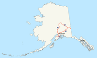
Interstate Highways in Alaska
Encyclopedia
Interstate Highway System
The Dwight D. Eisenhower National System of Interstate and Defense Highways, , is a network of limited-access roads including freeways, highways, and expressways forming part of the National Highway System of the United States of America...
in Alaska
Alaska
Alaska is the largest state in the United States by area. It is situated in the northwest extremity of the North American continent, with Canada to the east, the Arctic Ocean to the north, and the Pacific Ocean to the west and south, with Russia further west across the Bering Strait...
, even though the routes do not connect directly to any highways in the contiguous United States
Contiguous United States
The contiguous United States are the 48 U.S. states on the continent of North America that are south of Canada and north of Mexico, plus the District of Columbia....
, except either by the Alaska Marine Highway System ferries or via Canadian
Canada
Canada is a North American country consisting of ten provinces and three territories. Located in the northern part of the continent, it extends from the Atlantic Ocean in the east to the Pacific Ocean in the west, and northward into the Arctic Ocean...
highways.
These routes are numbered A-1 through A-4 and receive similar funding to interstates in other states; however they are not signed
Unsigned highway
An unsigned highway is a highway that has been assigned a route number, but does not bear conventional road markings that would normally be used to identify the route with that number...
with interstate highway shields.
They follow various combinations of Alaska Routes, which generally fail to meet Interstate Highway standards
Interstate Highway standards
Standards for Interstate Highways in the United States are defined by the American Association of State Highway and Transportation Officials in the publication A Policy on Design Standards - Interstate System...
, being for the most part two-lane rural highways without controlled access. The federal government
Federal government of the United States
The federal government of the United States is the national government of the constitutional republic of fifty states that is the United States of America. The federal government comprises three distinct branches of government: a legislative, an executive and a judiciary. These branches and...
established the classification of these roads as Interstate Highways, primarily for funding purposes. Limited-access freeways exist only within and near Anchorage
Anchorage, Alaska
Anchorage is a unified home rule municipality in the southcentral part of the U.S. state of Alaska. It is the northernmost major city in the United States...
, Fairbanks
Fairbanks, Alaska
Fairbanks is a home rule city in and the borough seat of the Fairbanks North Star Borough in the U.S. state of Alaska.Fairbanks is the largest city in the Interior region of Alaska, and second largest in the state behind Anchorage...
, and Wasilla.
Routes
| Route | Length mi |
Length km |
From | To | Highway names |
|---|---|---|---|---|---|
| Anchorage Anchorage, Alaska Anchorage is a unified home rule municipality in the southcentral part of the U.S. state of Alaska. It is the northernmost major city in the United States... |
Canadian border Canada Canada is a North American country consisting of ten provinces and three territories. Located in the northern part of the continent, it extends from the Atlantic Ocean in the east to the Pacific Ocean in the west, and northward into the Arctic Ocean... |
Glenn Highway Glenn Highway -References:* Pasch, A. D., K. C. May. 2001. Taphonomy and paleoenvironment of hadrosaur from the Matanuska Formation in South-Central Alaska. In: Mesozioc Vertebrate Life. Ed.s Tanke, D. H., Carpenter, K., Skrepnick, M. W. Indiana University Press. Pages 219-236.-External links:**... , Richardson Highway Richardson Highway The Richardson Highway is a highway in the U.S. state of Alaska, running 368 miles from Valdez to Fairbanks. It is marked as Alaska Route 4 from Valdez to Delta Junction and as Alaska Route 2 from there to Fairbanks. It is also connects segments of Alaska Route 1 between the Glenn Highway and the... , Tok Cut-Off Tok Cut-Off The Tok Cut-Off is a highway in the U.S. state of Alaska, running 125 miles from Gakona Junction on the Richardson Highway, 14 miles north of Glennallen, to Tok on the Alaska Highway.... , Alaska Highway Alaska Highway The Alaska Highway was constructed during World War II for the purpose of connecting the contiguous U.S. to Alaska through Canada. It begins at the junction with several Canadian highways in Dawson Creek, British Columbia and runs to Delta Junction, Alaska, via Whitehorse, Yukon... |
|||
| Tok Tok, Alaska Tok is a census-designated place in Southeast Fairbanks Census Area, Alaska, United States. The population was 1,393 at the 2000 census.-Geography:... |
Fairbanks Fairbanks, Alaska Fairbanks is a home rule city in and the borough seat of the Fairbanks North Star Borough in the U.S. state of Alaska.Fairbanks is the largest city in the Interior region of Alaska, and second largest in the state behind Anchorage... |
Alaska Highway Alaska Highway The Alaska Highway was constructed during World War II for the purpose of connecting the contiguous U.S. to Alaska through Canada. It begins at the junction with several Canadian highways in Dawson Creek, British Columbia and runs to Delta Junction, Alaska, via Whitehorse, Yukon... , Richardson Highway Richardson Highway The Richardson Highway is a highway in the U.S. state of Alaska, running 368 miles from Valdez to Fairbanks. It is marked as Alaska Route 4 from Valdez to Delta Junction and as Alaska Route 2 from there to Fairbanks. It is also connects segments of Alaska Route 1 between the Glenn Highway and the... |
|||
| Anchorage Anchorage, Alaska Anchorage is a unified home rule municipality in the southcentral part of the U.S. state of Alaska. It is the northernmost major city in the United States... |
Soldotna Soldotna, Alaska As of the census of 2000, there were 3,759 people, 1,465 households, and 969 families residing in the city. As of 2008, the population was close to 4,200. The population density was 541.9 people per square mile . There were 1,670 housing units at an average density of 240.7 per square mile... |
Seward Highway Seward Highway The Seward Highway is a highway in the U.S. state of Alaska that extends 127 miles from Seward to Anchorage. It was completed in 1951 and runs through the scenic Kenai Peninsula and Turnagain Arm, for which it was designated an All-American Road by the U.S... , Sterling Highway Sterling Highway The Sterling Highway is a 142-mile highway in the Southcentral region of the U.S. state of Alaska, leading from the Seward Highway at Tern Lake Junction, south of Anchorage, to Homer.... |
|||
| Palmer Palmer, Alaska Palmer is the borough seat of the Matanuska-Susitna Borough in the state of Alaska, USA. It is part of the Anchorage Metropolitan Statistical Area. As of the 2010 census, the population of the city is 5,937.... |
Fairbanks Fairbanks, Alaska Fairbanks is a home rule city in and the borough seat of the Fairbanks North Star Borough in the U.S. state of Alaska.Fairbanks is the largest city in the Interior region of Alaska, and second largest in the state behind Anchorage... |
Parks Highway George Parks Highway The George Parks Highway , usually called simply the Parks Highway, runs 323 miles from the Glenn Highway 35 miles north of Anchorage to Fairbanks in the Alaska Interior... |
|||