
Puerto Rico Highway 22
Encyclopedia
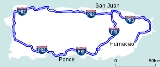
PR-22 is a 51-mile (83-km) long toll road
in the north coast of Puerto Rico
that connects the cities of San Juan
and Hatillo
. The road is also known as the José de Diego Expressway (Spanish: Expreso De Diego), and is part of unsigned Interstate PR-2. It is a 4-lane road for much of its length, but expands to up to 12 lanes in the San Juan metro area. The road is frequently congested, in particular during rush hour due to heavy commuter traffic.
The road is part of the U.S. Interstate Highway System.
PR-22 runs parallel to PR-2. Unlike PR-22, PR-2 is not a controlled-access road, and has numerous traffic signals throughout the full run of its course. The construction of highway PR-22 reduced congestion on PR-2. The eastern terminus is at PR-26 (a non-tolled freeway) in Santurce, and passes through the Minillas Tunnel before its terminus at PR-26. The freeway bypasses all of the cities PR-2 passes through (see below under "Course of the Expressway"). PR-22's western terminus is at PR-2 in Hatillo
. From there, PR-2 continues to Aguadilla and Mayagüez, ending in Ponce
.
}
|
|-
|
|13
|
|
|-
|rowspan=3|Toa Baja
|
|16
|
|
|-
|
|17
|
|
|-
|
|22
|
|Signed as Exits 22A (north) and 22B (south)
|-
|rowspan=1|Dorado
|
|24
|
|
|-
|rowspan=3|Vega Alta
|
|27
|
|
|-
|
|31
|
|Westbound exit and Eastbound entrance
|-
|
|32
|
|
|-
|rowspan=3|Vega Baja
|
|35
|
|
|-
|
|38
|Vega Baja, Avenida Trio Vegabajeno
|Westbound exit and Eastbound entrance
|-
|
|42
|
|
|-
|rowspan=2|Manati
|
|46
|
|Westbound exit and Eastbound entrance
|-
|
|48
||
|
|-
|rowspan=2|Barceloneta
|
|55
|
|
|-
|
|57
|
|
|-
|rowspan=4|Arecibo
|
|64
|
|Toll with no Electronic toll collection on westbound on-ramp
|-
|
|71
|
|
|-
|
|75
|
|Signed as Exits 75A (north) and 75B (south)
|-
|
|77
|
|Signed as Exits 77A (north) and 77B (south)
|-
|rowspan=1|Hatillo
|
|84
|
|Splits into PR-2
PRI-2 continues westbound via PR-2.
|}
, Vega Alta, and Guaynabo. Westbound tolls are found in Toa Baja and Manatí
. The Arecibo
toll plaza collects tolls in both directions. All toll plazas have restroom facilities; the Vega Alta toll plaza also has an ATM
.
PR-22 has seven toll plazas (three eastbound, two westbound, one two-way, and one ramp).
The future segment from Aguadilla to Hatillo is expected to have at least one toll plaza, however, nothing has been announced on whether the toll plaza(s) will be one-way or two-way, and where they will be located.
Toll road
A toll road is a privately or publicly built road for which a driver pays a toll for use. Structures for which tolls are charged include toll bridges and toll tunnels. Non-toll roads are financed using other sources of revenue, most typically fuel tax or general tax funds...
in the north coast of Puerto Rico
Puerto Rico
Puerto Rico , officially the Commonwealth of Puerto Rico , is an unincorporated territory of the United States, located in the northeastern Caribbean, east of the Dominican Republic and west of both the United States Virgin Islands and the British Virgin Islands.Puerto Rico comprises an...
that connects the cities of San Juan
San Juan, Puerto Rico
San Juan , officially Municipio de la Ciudad Capital San Juan Bautista , is the capital and most populous municipality in Puerto Rico, an unincorporated territory of the United States. As of the 2010 census, it had a population of 395,326 making it the 46th-largest city under the jurisdiction of...
and Hatillo
Hatillo, Puerto Rico
Hatillo is a municipality located on Puerto Rico's north coast, bordered by the Atlantic Ocean to the north, Lares and Utuado to the south, Camuy to the west, and Arecibo to the east. According to the 2000 US Census Hatillo is spread over 9 wards and Hatillo Pueblo...
. The road is also known as the José de Diego Expressway (Spanish: Expreso De Diego), and is part of unsigned Interstate PR-2. It is a 4-lane road for much of its length, but expands to up to 12 lanes in the San Juan metro area. The road is frequently congested, in particular during rush hour due to heavy commuter traffic.
The road is part of the U.S. Interstate Highway System.
Route description
PR-22 is Puerto Rico's most traveled highway.PR-22 runs parallel to PR-2. Unlike PR-22, PR-2 is not a controlled-access road, and has numerous traffic signals throughout the full run of its course. The construction of highway PR-22 reduced congestion on PR-2. The eastern terminus is at PR-26 (a non-tolled freeway) in Santurce, and passes through the Minillas Tunnel before its terminus at PR-26. The freeway bypasses all of the cities PR-2 passes through (see below under "Course of the Expressway"). PR-22's western terminus is at PR-2 in Hatillo
Hatillo, Puerto Rico
Hatillo is a municipality located on Puerto Rico's north coast, bordered by the Atlantic Ocean to the north, Lares and Utuado to the south, Camuy to the west, and Arecibo to the east. According to the 2000 US Census Hatillo is spread over 9 wards and Hatillo Pueblo...
. From there, PR-2 continues to Aguadilla and Mayagüez, ending in Ponce
Ponce, Puerto Rico
Ponce is both a city and a municipality in the southern part of Puerto Rico. The city is the seat of the municipal government.The city of Ponce, the fourth most populated in Puerto Rico, and the most populated outside of the San Juan metropolitan area, is named for Juan Ponce de León y Loayza, the...
.
Future
PR-22 is planned to be extended to Aguadilla. The extension will be built as part of a public–private partnership, who will maintain and operate PR-22 for the next 50 years. The contract is expected to be put up for bid by the end of 2010, with a 6 year goal for completion of the extension.Privatization
The Autopistas Metropolitanas de Puerto Rico consortium, comprised by Abertis Infraestructuras and Goldman Sachs Infrastructure Partners II LP, placed the winning bid for the 40-year PR-22 and PR-5 highway concession. The highways generate between $90 million and $95 million annually in toll revenue, which will now go to the private operators.Exit list
| Municipality | Km | Exit | Destinations | Notes |
|---|---|---|---|---|
| Bayamon Bayamón, Puerto Rico Bayamón is a municipality of Puerto Rico located on the northern coastal valley, north of Aguas Buenas and Comerío; south of Toa Baja and Cataño; west of Guaynabo; and east of Toa Alta and Naranjito. Bayamón is spread over 11 wards and Bayamón Pueblo... |
9 | |||
| 11 |
|
|-
|
|13
|
|
|-
|rowspan=3|Toa Baja
Toa Baja, Puerto Rico
Toa Baja is a municipality of Puerto Rico located in the northern coast, north of Toa Alta and Bayamón; east of Dorado; and west of Cataño. Toa Baja is spread over 5 wards and Toa Baja Pueblo . It is part of the San Juan-Caguas-Guaynabo Metropolitan Statistical Area.Toa Baja considered to be a...
|
|16
|
|
|-
|
|17
|
|
|-
|
|22
|
|Signed as Exits 22A (north) and 22B (south)
|-
|rowspan=1|Dorado
Dorado, Puerto Rico
Dorado is a small tourist town in the northern coast of Puerto Rico, west of San Juan and is located in the northern region of the island, bordering the Atlantic Ocean, north of Toa Alta, east of Vega Alta, and west of Toa Baja. Dorado is spread over five barrios and Dorado Pueblo...
|
|24
|
|
|-
|rowspan=3|Vega Alta
Vega Alta, Puerto Rico
Vega Alta is a municipality of Puerto Rico. Vega Alta is located on the northern coast of the island, north of Morovis and Corozal; east of Vega Baja; and west of Dorado with an area of . Vega Alta is spread over seven wards and Vega Alta Pueblo...
|
|27
|
|
|-
|
|31
|
|Westbound exit and Eastbound entrance
|-
|
|32
|
|
|-
|rowspan=3|Vega Baja
Vega Baja, Puerto Rico
Vega Baja is a municipality in north central Puerto Rico located in the northern coast, north of Morovis; east of Manatí; and west of Vega Alta. Vega Baja is spread over 13 wards and Vega Baja Pueblo...
|
|35
|
|
|-
|
|38
|Vega Baja, Avenida Trio Vegabajeno
|Westbound exit and Eastbound entrance
|-
|
|42
|
|
|-
|rowspan=2|Manati
Manatí, Puerto Rico
Manatí is a municipality of Puerto Rico in the northern coast, north of Morovis and Ciales; east of Florida and Barceloneta; and west of Vega Baja. Manatí is spread over 8 wards and Manatí Pueblo...
|
|46
|
|Westbound exit and Eastbound entrance
|-
|
|48
||
|
|-
|rowspan=2|Barceloneta
Barceloneta, Puerto Rico
Barceloneta is a municipality in Puerto Rico and is located in the north region, bordering the Atlantic Ocean, north of Florida, east of Arecibo and west of Manati. Barceloneta is spread over 3 wards and Barceloneta Pueblo...
|
|55
|
|
|-
|
|57
|
|
|-
|rowspan=4|Arecibo
Arecibo, Puerto Rico
Arecibo is a municipality in the northern midwest coast of Puerto Rico and located by the Atlantic Ocean, north of Utuado and Ciales; east of Hatillo; and west of Barceloneta, and Florida. Arecibo is spread over 18 wards and Arecibo Pueblo...
|
|64
|
|Toll with no Electronic toll collection on westbound on-ramp
|-
|
|71
|
|
|-
|
|75
|
|Signed as Exits 75A (north) and 75B (south)
|-
|
|77
|
|Signed as Exits 77A (north) and 77B (south)
|-
|rowspan=1|Hatillo
Hatillo, Puerto Rico
Hatillo is a municipality located on Puerto Rico's north coast, bordered by the Atlantic Ocean to the north, Lares and Utuado to the south, Camuy to the west, and Arecibo to the east. According to the 2000 US Census Hatillo is spread over 9 wards and Hatillo Pueblo...
|
|84
|
|Splits into PR-2
PRI-2 continues westbound via PR-2.
|}
Toll plazas
PR-22 is maintained by a system of tolls managed by the Puerto Rico Department of Transportation and Public Works. All of its toll plazas have express lanes. There are eastbound tolls in HatilloHatillo, Puerto Rico
Hatillo is a municipality located on Puerto Rico's north coast, bordered by the Atlantic Ocean to the north, Lares and Utuado to the south, Camuy to the west, and Arecibo to the east. According to the 2000 US Census Hatillo is spread over 9 wards and Hatillo Pueblo...
, Vega Alta, and Guaynabo. Westbound tolls are found in Toa Baja and Manatí
Manatí
Manatí may refer to:*Manatí, Puerto Rico*Manatí, Atlántico in Atlantico, Colombia*Manatí, Cuba, a municipality in Las Tunas, CubaManatí is also the Spanish word for manatee.*See also: Special:Allpages/Manatí...
. The Arecibo
Arecibo
Arecibo may refer to:*Arecibo, Puerto Rico, a municipality located by the Atlantic Ocean*Arecibo Observatory, a very sensitive radio telescope located approximately south-southwest from the city of Arecibo...
toll plaza collects tolls in both directions. All toll plazas have restroom facilities; the Vega Alta toll plaza also has an ATM
Automated teller machine
An automated teller machine or automatic teller machine, also known as a Cashpoint , cash machine or sometimes a hole in the wall in British English, is a computerised telecommunications device that provides the clients of a financial institution with access to financial transactions in a public...
.
PR-22 has seven toll plazas (three eastbound, two westbound, one two-way, and one ramp).
| Location | Toll | Direction | AutoExpreso acceptance |
replenishment | Notes |
|---|---|---|---|---|---|
| Hatillo Hatillo, Puerto Rico Hatillo is a municipality located on Puerto Rico's north coast, bordered by the Atlantic Ocean to the north, Lares and Utuado to the south, Camuy to the west, and Arecibo to the east. According to the 2000 US Census Hatillo is spread over 9 wards and Hatillo Pueblo... |
$1.00 | Eastbound |  |
 |
|
| Arecibo Arecibo, Puerto Rico Arecibo is a municipality in the northern midwest coast of Puerto Rico and located by the Atlantic Ocean, north of Utuado and Ciales; east of Hatillo; and west of Barceloneta, and Florida. Arecibo is spread over 18 wards and Arecibo Pueblo... / Factor |
$0.50 | Westbound (ramp) | |
|
Only ramp toll plaza on PR-22 |
| Arecibo Arecibo, Puerto Rico Arecibo is a municipality in the northern midwest coast of Puerto Rico and located by the Atlantic Ocean, north of Utuado and Ciales; east of Hatillo; and west of Barceloneta, and Florida. Arecibo is spread over 18 wards and Arecibo Pueblo... |
$0.75 | Two-way | |
|
Only two-way toll plaza on PR-22 Features unique roof design |
| Manatí Manatí, Puerto Rico Manatí is a municipality of Puerto Rico in the northern coast, north of Morovis and Ciales; east of Florida and Barceloneta; and west of Vega Baja. Manatí is spread over 8 wards and Manatí Pueblo... |
$1.50 | Westbound | |
|
|
| Vega Alta Vega Alta, Puerto Rico Vega Alta is a municipality of Puerto Rico. Vega Alta is located on the northern coast of the island, north of Morovis and Corozal; east of Vega Baja; and west of Dorado with an area of . Vega Alta is spread over seven wards and Vega Alta Pueblo... |
$1.00 | Eastbound | |
|
|
| Toa Baja Toa Baja, Puerto Rico Toa Baja is a municipality of Puerto Rico located in the northern coast, north of Toa Alta and Bayamón; east of Dorado; and west of Cataño. Toa Baja is spread over 5 wards and Toa Baja Pueblo . It is part of the San Juan-Caguas-Guaynabo Metropolitan Statistical Area.Toa Baja considered to be a... |
$1.00 | Westbound | |
|
|
| Guaynabo Guaynabo, Puerto Rico Guaynabo is a municipality in the northern part of Puerto Rico, located in the northern coast of the island, north of Aguas Buenas; south of Cataño; east of Bayamón; and west of San Juan... / Fort Buchanan Fort Buchanan, Puerto Rico United States Army Garrison Fort Buchanan, Puerto Rico is the U.S. Army’s only active military installation in Puerto Rico. Located in the Metropolitan area of San Juan, it serves under the direct control of the Installation Management Command, Southeast Region... |
$1.00 | Eastbound | |
|
Toll plaza with the most lanes in Puerto Rico |
The future segment from Aguadilla to Hatillo is expected to have at least one toll plaza, however, nothing has been announced on whether the toll plaza(s) will be one-way or two-way, and where they will be located.