

Puerto Rico Highway 12
Encyclopedia
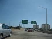
Puerto Rico Highway 12, also called Malecon Avenue, and Santiago de los Caballeros Avenue, is a 5.28-kilometer, limited-access highway entirely located within the city limits of Ponce, Puerto Rico
, and connecting Puerto Rico Highway 14
to the La Guancha
area in Barrio
Playa in Ponce. It is similar to a freeway but has one traffic light near its intersection with PR-14. The highway has four exits: PR-52, PR-2
, PR-133/Calle Comercio, and PR-163. Since PR-12's southern terminus is at the Port of Ponce, its traffic volume is expected to grow as construction in the new Port of the Americas is completed.
Ponce, Puerto Rico
Ponce is both a city and a municipality in the southern part of Puerto Rico. The city is the seat of the municipal government.The city of Ponce, the fourth most populated in Puerto Rico, and the most populated outside of the San Juan metropolitan area, is named for Juan Ponce de León y Loayza, the...
, and connecting Puerto Rico Highway 14
Puerto Rico Highway 14
Puerto Rico Highway 14 is a main highway connecting Cayey, Puerto Rico to Ponce, Puerto Rico. The road uses the same path as the historic old Carretera Central.-Road description:...
to the La Guancha
Paseo Tablado La Guancha
The La Guancha Boardwalk is a boardwalk in the La Guancha sector of the La Playa barrio in the city of Ponce, Puerto Rico, facing the Caribbean Sea and built under the administration of Rafael Cordero Santiago, Mayor of Ponce from 1989 to 2004, at a cost of 2.6 million dollars. It was inaugurated...
area in Barrio
Barrio
Barrio is a Spanish word meaning district or neighborhood.-Usage:In its formal usage in English, barrios are generally considered cohesive places, sharing, for example, a church and traditions such as feast days...
Playa in Ponce. It is similar to a freeway but has one traffic light near its intersection with PR-14. The highway has four exits: PR-52, PR-2
Puerto Rico Highway 2
Puerto Rico Highway 2, the longest highway in the Commonwealth of Puerto Rico at about 156 miles long, connects San Juan to Ponce....
, PR-133/Calle Comercio, and PR-163. Since PR-12's southern terminus is at the Port of Ponce, its traffic volume is expected to grow as construction in the new Port of the Americas is completed.