
List of National Historic Landmarks in Montana
Encyclopedia
The List of National Historic Landmarks in Montana contains the landmarks designated by the U.S. Federal Government for the U.S. state
of Montana
.
There are 25 National Historic Landmark
s (NHLs) in Montana.
The United States
National Historic Landmark
program is operated under the auspices of the National Park Service
, and recognizes structures, districts, objects, and similar resources nationwide according to a list of criteria of national significance.
The state
of Montana
is home to 25 of these landmarks, emphasizing Montana's frontier heritage and the passage of the Lewis and Clark Expedition
, Montana's contributions to the national park
movement, and other themes.
Two sites in Montana extend across the Idaho
state line, and are listed by the National Park Service as Idaho NHLs.
The table below lists all 25 of these sites, along with added detail and description.
__NOEDITSECTION__
U.S. state
A U.S. state is any one of the 50 federated states of the United States of America that share sovereignty with the federal government. Because of this shared sovereignty, an American is a citizen both of the federal entity and of his or her state of domicile. Four states use the official title of...
of Montana
Montana
Montana is a state in the Western United States. The western third of Montana contains numerous mountain ranges. Smaller, "island ranges" are found in the central third of the state, for a total of 77 named ranges of the Rocky Mountains. This geographical fact is reflected in the state's name,...
.
There are 25 National Historic Landmark
National Historic Landmark
A National Historic Landmark is a building, site, structure, object, or district, that is officially recognized by the United States government for its historical significance...
s (NHLs) in Montana.
The United States
United States
The United States of America is a federal constitutional republic comprising fifty states and a federal district...
National Historic Landmark
National Historic Landmark
A National Historic Landmark is a building, site, structure, object, or district, that is officially recognized by the United States government for its historical significance...
program is operated under the auspices of the National Park Service
National Park Service
The National Park Service is the U.S. federal agency that manages all national parks, many national monuments, and other conservation and historical properties with various title designations...
, and recognizes structures, districts, objects, and similar resources nationwide according to a list of criteria of national significance.
The state
U.S. state
A U.S. state is any one of the 50 federated states of the United States of America that share sovereignty with the federal government. Because of this shared sovereignty, an American is a citizen both of the federal entity and of his or her state of domicile. Four states use the official title of...
of Montana
Montana
Montana is a state in the Western United States. The western third of Montana contains numerous mountain ranges. Smaller, "island ranges" are found in the central third of the state, for a total of 77 named ranges of the Rocky Mountains. This geographical fact is reflected in the state's name,...
is home to 25 of these landmarks, emphasizing Montana's frontier heritage and the passage of the Lewis and Clark Expedition
Lewis and Clark Expedition
The Lewis and Clark Expedition, or ″Corps of Discovery Expedition" was the first transcontinental expedition to the Pacific Coast by the United States. Commissioned by President Thomas Jefferson and led by two Virginia-born veterans of Indian wars in the Ohio Valley, Meriwether Lewis and William...
, Montana's contributions to the national park
National park
A national park is a reserve of natural, semi-natural, or developed land that a sovereign state declares or owns. Although individual nations designate their own national parks differently A national park is a reserve of natural, semi-natural, or developed land that a sovereign state declares or...
movement, and other themes.
Two sites in Montana extend across the Idaho
Idaho
Idaho is a state in the Rocky Mountain area of the United States. The state's largest city and capital is Boise. Residents are called "Idahoans". Idaho was admitted to the Union on July 3, 1890, as the 43rd state....
state line, and are listed by the National Park Service as Idaho NHLs.
The table below lists all 25 of these sites, along with added detail and description.
__NOEDITSECTION__
| Landmark name | Image | Date desig. | Locality |
County | Description | |
|---|---|---|---|---|---|---|
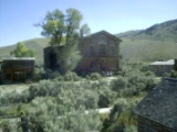
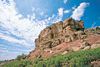
| Bannack Historic District Bannack, Montana Bannack is a ghost town in Beaverhead County, Montana, United States, located on Grasshopper Creek, approximately upstream from where Grasshopper Creek joins with the Beaverhead River south of Dillon.-History:... |
 |
Bannack Bannack, Montana Bannack is a ghost town in Beaverhead County, Montana, United States, located on Grasshopper Creek, approximately upstream from where Grasshopper Creek joins with the Beaverhead River south of Dillon.-History:... 45°9′40"N 112°59′44"W |
Beaverhead Beaverhead County, Montana -National protected areas:* Beaverhead National Forest * Big Hole National Battlefield* Nez Perce National Historical Park * Red Rock Lakes National Wildlife Refuge-History:... |
Site of Montana's first major gold discovery in 1862, and served as the capital of Montana Territory briefly.http://tps.cr.nps.gov/nhl/detail.cfm?ResourceId=297&ResourceType=District | ||
| Butte Historic District Butte-Anaconda Historic District Butte-Anaconda Historic District is a historic district that spans parts of Walkerville, Butte and Anaconda, Montana. It has the most resources of any U.S... |
 |
Butte Butte, Montana Butte is a city in Montana and the county seat of Silver Bow County, United States. In 1977, the city and county governments consolidated to form the sole entity of Butte-Silver Bow. As of the 2010 census, Butte's population was 34,200... 46.01646°N 112.5361°W |
Deer Lodge Deer Lodge County, Montana -National protected areas:*Beaverhead National Forest *Deerlodge National Forest -Demographics:As of the census of 2000, there were 9,417 people, 3,995 households, and 2,524 families residing in the county. The population density was 13 people per square mile . There were 4,958 housing units at an... and Silver Bow Silver Bow County, Montana -National protected areas:*Beaverhead National Forest *Deerlodge National Forest -Demographics:As of the census of 2000, there were 34,606 people, 14,432 households, and 8,933 families residing in the county. The population density was 48 people per square mile . There were 16,176 housing units at... |
One of the largest and most notorious copper boomtowns in the American West; the district includes more than 6,000 contributing properties. | ||
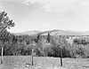
| Camp Disappointment Camp Disappointment Camp Disappointment is the northernmost campsite of the Lewis and Clark expedition, on its return trip from Washington.It was declared a National Historic Landmark in 1966.... |
image pending | Browning Browning, Montana Browning is a town in Glacier County, Montana, United States. The population was 1,016 at the 2010 census.-Geography:Browning is located at .... 48°35′57"N 112°47′53"W |
Glacier Glacier County, Montana -National protected areas:* Glacier National Park * Lewis and Clark National Forest -Demographics:As of the census of 2000, there were 13,247 people, 4,304 households, and 3,245 families residing in the county. The population density was 4 people per square mile . There were 5,243 housing units... |
Lewis and Clark Expedition Lewis and Clark Expedition The Lewis and Clark Expedition, or ″Corps of Discovery Expedition" was the first transcontinental expedition to the Pacific Coast by the United States. Commissioned by President Thomas Jefferson and led by two Virginia-born veterans of Indian wars in the Ohio Valley, Meriwether Lewis and William... site. |
||
| Chief Joseph Battle- ground of Bear's Paw Battle of Bear Paw The Battle of Bear Paw was the final engagement of the Nez Perce War. Some of the Nez Perce were able to escape to Canada, but Chief Joseph was forced to surrender the majority of his tribe to Oliver O. Howard... |
 |
Chinook Chinook, Montana Chinook is a city in and the county seat of Blaine County, Montana, United States. The population was 1,386 at the 2000 census. Points of interest are the Bear Paw Battlefield Museum located in the small town's center and the Bear Paw Battlefield, located just twenty miles south of... 48°22′39"N 109°12′34"W |
Blaine Blaine County, Montana -National protected areas:* Black Coulee National Wildlife Refuge* Nez Perce National Historical Park * Upper Missouri River Breaks National Monument -Economy:The main industry in Blaine County is Agriculture... |
Site of the final engagement of the Nez Perce War. | ||
| Chief Plenty Coups (Alek-Chea-Ahoosh) Home | .jpg) |
Pryor Pryor, Montana Pryor is a census-designated place in Big Horn County, Montana, United States. The population was 628 at the 2000 census. The area is named for Nathaniel Hale Pryor, a sergeant in the Lewis and Clark Expedition.-Geography:... 45°25′35"N 108°32′54"W |
Big Horn Big Horn County, Montana - National protected areas :* Bighorn Canyon National Recreation Area * Little Bighorn Battlefield National Monument- Economy :Coal Mining and Agriculture both play major roles in Big Horn County’s economy... |
The 2-story house of Crow Nation Crow Nation The Crow, also called the Absaroka or Apsáalooke, are a Siouan people of Native Americans who historically lived in the Yellowstone River valley, which extends from present-day Wyoming, through Montana and into North Dakota. They now live on a reservation south of Billings, Montana and in several... chief Plenty Coups Plenty Coups Plenty Coups was a Crow chief and visionary leader. He allied Crow with the whites when the war for the West was being fought, because the Sioux and Cheyenne were the traditional enemies of the Crow... during 1884-1932, plus a log store and the Plenty Coups Spring. |
||
| Fort Benton Fort Benton, Montana Fort Benton is a city in and the county seat of Chouteau County, Montana, United States. A portion of the city was designated as a National Historic Landmark District in 1961. Established a full generation beforethe U.S... |
Fort Benton Fort Benton, Montana Fort Benton is a city in and the county seat of Chouteau County, Montana, United States. A portion of the city was designated as a National Historic Landmark District in 1961. Established a full generation beforethe U.S... |
Chouteau Chouteau County, Montana -National protected areas:* Lewis and Clark National Forest * Upper Missouri River Breaks National Monument -Economy:Chouteau County is the largest winter wheat producer for the state of Montana... |
Established as a fur trading center in 1847, the fort prospered with the growth of steamboat traffic starting in 1859 and an 1862 gold strike, but declined with the advent of the railroad. | |||
| Going-to-the-Sun Road Going-to-the-Sun Road Going-to-the-Sun Road is the only road through the heart of Glacier National Park in Montana, USA. It was completed in 1932, and it is the only road that crosses the park, going over the Continental Divide at Logan Pass. A fleet of 1930s red tour buses "jammers", rebuilt in 2001 to run on propane... |
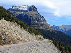 |
Glacier National Park 48°44′N 113°46′W |
Flathead Flathead County, Montana -National protected areas:* Pacific Northwest National Scenic Trail * Flathead National Forest * Glacier National Park * Kootenai National Forest * Lolo National Forest * Lost Trail National Wildlife Refuge-Demographics:... and Glacier Glacier County, Montana -National protected areas:* Glacier National Park * Lewis and Clark National Forest -Demographics:As of the census of 2000, there were 13,247 people, 4,304 households, and 3,245 families residing in the county. The population density was 4 people per square mile . There were 5,243 housing units... |
Main parkway through the heart of Glacier National Park.http://tps.cr.nps.gov/nhl/detail.cfm?ResourceId=2200&ResourceType=District | ||
| Grant-Kohrs Ranch Grant-Kohrs Ranch National Historic Site Established by Canadian fur trader Johnny Grant, and expanded by cattle baron Conrad Kohrs, Grant-Kohrs Ranch National Historic Site commemorates the Western cattle industry from its 1850s inception through recent times. The park was created in 1972, and embraces 1,500 acres and 90 structures. The... |
 |
Deer Lodge Deer Lodge, Montana Deer Lodge is a city in and the county seat of Powell County, Montana, United States. The population was 3,421 at the 2000 census. The city is perhaps best known as the home of the Montana State Prison, a major local employer... 46°24′30"N 112°44′22"W |
Powell Powell County, Montana -National protected areas:* Beaverhead-Deerlodge National Forest * Flathead National Forest * Grant-Kohrs Ranch National Historic Site* Helena National Forest * Lolo National Forest * Bob Marshall Wilderness Area... |
John Grant John Grant John Grant may refer to:*John Grant , Screenwriter, wrote for Abbott and Costello*Johannes Grant, engineer, believed by some scholars to have been Scottish, who fought in the Siege of Constantinople*John Gaston Grant , U.S... , the original owner of the ranch, from 1853, is sometimes credited with founding the range-cattle industry in Montana. Conrad Kohrs Conrad Kohrs Conrad Kohrs, born Carsten Conrad Kohrs was a Montana cattle rancher .He was born in Holstein, a province that was ethnically and culturally German and part of the German Confederation but ruled at the time in personal union by Denmark... , who bought the ranch c.1866, was among the foremost "cattle kings" of his era. |
||
| Great Falls Portage Great Falls Portage Great Falls Portage is the site on the Missouri River that was an arduous portage site for the Lewis and Clark expedition in 1805. On the upriver trip, the 18 mile portage took 31 days.It was declared a National Historic Landmark in 1966.... |
image pending | Great Falls Great Falls, Montana Great Falls is a city in and the county seat of Cascade County, Montana, United States. The population was 58,505 at the 2010 census. It is the principal city of the Great Falls, Montana Metropolitan Statistical Area, which encompasses all of Cascade County... |
Cascade Cascade County, Montana -National protected areas:*Benton Lake National Wildlife Refuge*Lewis and Clark National Forest -Economy:Malmstrom Air Force Base is a driving force in the regional economy... |
The Lewis and Clark Expedition undertook an 18-mile, 31-day portage at Great Falls, one of the most difficult ordeals of their westward trip. The Great Falls Portage NHL is within Giant Springs State Park. | ||
| Great Northern Railway Buildings Great Northern Railway Buildings Great Northern Railway Buildings is a National Historic Landmark that now includes five complexes of buildings in Glacier National Park. The buildings were built by Great Northern Railway.... |
 |
Glacier National Park 48.76812°N 113.76982°W |
Flathead Flathead County, Montana -National protected areas:* Pacific Northwest National Scenic Trail * Flathead National Forest * Glacier National Park * Kootenai National Forest * Lolo National Forest * Lost Trail National Wildlife Refuge-Demographics:... and Glacier Glacier County, Montana -National protected areas:* Glacier National Park * Lewis and Clark National Forest -Demographics:As of the census of 2000, there were 13,247 people, 4,304 households, and 3,245 families residing in the county. The population density was 4 people per square mile . There were 5,243 housing units... |
These lodges or associated buildings, dated c.1913-1915, represent Europe Europe Europe is, by convention, one of the world's seven continents. Comprising the westernmost peninsula of Eurasia, Europe is generally 'divided' from Asia to its east by the watershed divides of the Ural and Caucasus Mountains, the Ural River, the Caspian and Black Seas, and the waterways connecting... an-style hostelries unique among NPS National Park Service The National Park Service is the U.S. federal agency that manages all national parks, many national monuments, and other conservation and historical properties with various title designations... concessions. The landmark contains 5 building groups:
|
||
| Hagen Site Hagen Site Hagen Site is an archaeological site that explores evidence on life in a Crow Indian community after the Crow tribe had split off from the Hidatsu.It was declared a National Historic Landmark in 1964.... |
image pending | Glendive Glendive, Montana Glendive is a city in and the county seat of Dawson County, Montana, United States. The population was 4,935 at the 2010 census.The town of Glendive is located in South Eastern Montana and is considered by many as an agricultural hub of Eastern Montana... |
Dawson Dawson County, Montana -Economy:Dawson County is known for its dryland grain, coal mines and gas and oil wells. There are 522 current farms and ranches, and 296 commercial businesses.-Demographics:... |
An archeological site representing one of the Crow villages after the tribe had split from the Hidatsa on the Missouri River (c. 1550-1675); site has evidence of horticulture and diet. | ||
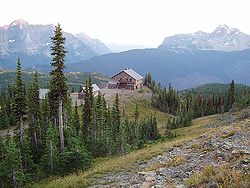
| Lake McDonald Lodge Lake McDonald Lodge Lake McDonald Lodge is a historic lodge located within Glacier National Park, on the southeast shore of Lake McDonald. The lodge is a -story structure built in a Swiss chalet style based on Kirtland Cutter's design. The foundation and first floor walls are built of stone, with a wood-frame... |
 |
Glacier National Park 48.61538°N 113.8781°W |
Flathead Flathead County, Montana -National protected areas:* Pacific Northwest National Scenic Trail * Flathead National Forest * Glacier National Park * Kootenai National Forest * Lolo National Forest * Lost Trail National Wildlife Refuge-Demographics:... |
A Swiss chalet-style hotel in Glacier National Park. | ||
| Lemhi Pass Lemhi Pass Lemhi Pass is a high mountain pass in the Beaverhead Mountains, part of the Bitterroot Range in the Rocky Mountains The pass lies on the Montana-Idaho border on the continental divide, at an elevation of 7373 feet above sea level.-History:... |
 |
Tendoy, ID Tendoy, Idaho Tendoy is an unincorporated community in Lemhi County, Idaho, United States. It is located at on State Highway 28, at an altitude of 4,842 feet... 44°58′29"N 113°26′41"W |
Beaver- head (MT) Beaverhead County, Montana -National protected areas:* Beaverhead National Forest * Big Hole National Battlefield* Nez Perce National Historical Park * Red Rock Lakes National Wildlife Refuge-History:... and Lemhi, ID Lemhi County, Idaho Lemhi County is a county located in the U.S. state of Idaho. The county was established in 1869, named after Fort Lemhi , a remote Mormon missionary settlement from 1855-58 in Bannock and Shoshone territory. As of the 2000 Census the county had a population of 7,806... |
See main listing under Idaho. | ||
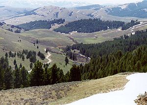
| Lolo Trail Lolo Pass (Idaho-Montana) Lolo Pass, elevation , is a mountain pass in the United States, in the Bitterroot Range of the northern Rocky Mountains. It is on the border between the states of Montana and Idaho, approximately west-southwest of Missoula, Montana.... |
 |
Lolo Hot Springs, ID 46°38′7"N 114°34′47"W | Missoula, MT Missoula County, Montana -National protected areas:*Bitterroot National Forest *Flathead National Forest *Lolo National Forest *Rattlesnake National Recreation Area-Demographics:... and Clear- water, ID Clearwater County, Idaho Clearwater County is a county located in the U.S. state of Idaho. Established in 1911, the county was named after the Clearwater River. As of the 2000 Census the county had a population of 8,930 . The county seat is Orofino.... |
|||
| Northeast Entrance Station Northeast Entrance Station The Northeast Entrance Station to Yellowstone National Park, in Park County, Montana, is a rustic log building that serves its purpose admirably. Designed by the National Park Service Branch of Plans and Design under the direction of Thomas Chalmers Vint, it was built in 1935. The entrance station... |
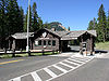 |
Yellowst. National Park Yellowstone National Park Yellowstone National Park, established by the U.S. Congress and signed into law by President Ulysses S. Grant on March 1, 1872, is a national park located primarily in the U.S. state of Wyoming, although it also extends into Montana and Idaho... 45.00281°N 110.0092°W |
Park Park County, Montana Park Counties in Montana and Wyoming are among the very few pairs of counties in the United States with the same name to border each other across state lines.-National protected areas:* Custer National Forest * Gallatin National Forest... |
Rustic National Park Service Rustic National Park Service rustic, also colloquially known as Parkitecture, is a style of architecture that arose in the United States National Park System to create buildings that harmonized with their natural environment. Since its founding, the National Park Service consistently has sought to provide... entrance station built Construction In the fields of architecture and civil engineering, construction is a process that consists of the building or assembling of infrastructure. Far from being a single activity, large scale construction is a feat of human multitasking... in 1935 that is a prime example of form fitting function Form follows function Form follows function is a principle associated with modern architecture and industrial design in the 20th century. The principle is that the shape of a building or object should be primarily based upon its intended function or purpose.... , in Yellowstone National Park Yellowstone National Park Yellowstone National Park, established by the U.S. Congress and signed into law by President Ulysses S. Grant on March 1, 1872, is a national park located primarily in the U.S. state of Wyoming, although it also extends into Montana and Idaho... . |
||
| Pictograph Cave | Billings Billings, Montana Billings is the largest city in the U.S. state of Montana, and is the principal city of the Billings Metropolitan Area, the largest metropolitan area in over... 45°44′12"N 108°25′47"W |
Yellow- stone Yellowstone County, Montana -National protected areas:* Nez Perce National Historical Park * Pompeys Pillar National Monument-Demographics:As of the census of 2000, there were 129,352 people, 52,084 households, and 34,219 families residing in the county. The population density was 49 people per square mile . There were... |
One of the key archeological sites used in determining the sequence of prehistoric occupation on the northwestern Plains. The deposits indicate occupation from 2600 BC to after 1800 AD. | |||
| Pompey's Pillar Pompeys Pillar National Monument Pompeys Pillar National Monument is a rock formation located in south central Montana, United States. Designated a National Monument on January 17, 2001, and managed by the U.S. Bureau of Land Management, it consists of only , making it one of the smallest National Monuments in the U.S... |
 |
Pompey's Pillar Pompey's Pillar, Montana Pompey's Pillar is an unincorporated community in Yellowstone County, Montana, United States.-History:Founded in 1907, Pompey's Pillar was built and named after the site of a famous natural landmark where William Clark inscribed his name on July 25, 1806 during his trip down the Yellowstone River... 45°59′43"N 108°0′20"W |
Yellow- stone Yellowstone County, Montana -National protected areas:* Nez Perce National Historical Park * Pompeys Pillar National Monument-Demographics:As of the census of 2000, there were 129,352 people, 52,084 households, and 34,219 families residing in the county. The population density was 49 people per square mile . There were... |
The massive natural block of sandstone was a major landmark on the Lewis and Clark Expedition Lewis and Clark Expedition The Lewis and Clark Expedition, or ″Corps of Discovery Expedition" was the first transcontinental expedition to the Pacific Coast by the United States. Commissioned by President Thomas Jefferson and led by two Virginia-born veterans of Indian wars in the Ohio Valley, Meriwether Lewis and William... . Clark's signature is carved on its surface. |
||
| Rankin Ranch Rankin Ranch Rankin Ranch was the home of Jeanette Rankin, whose 1916 election to the United States House of Representatives made her the first woman elected to the House. Her legacy includes a penchant for pacifism, women's rights, and social reform... |
Avalanche Gulch45°12′37"N 111°45′21"W | Broad- water Broadwater County, Montana -Economy:Agriculture is one of the primary industries in Broadwater County. RY Timber and Wheat Montana Bakery were the largest private employers according to the 2000 Census.-Demographics:... |
Residence (1923-56) of Jeanette Rankin, first woman elected to U.S. House of Representatives (1916), had two terms 1917-19 & 1941-43, only member to oppose the declaration of war against Japan in 1941. | |||
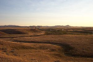
| Rosebud Battlefield-Where the Girl Saved Her Brother Rosebud Battlefield State Park Rosebud Battlefield State Park, or Rosebud Battlefield-Where the Girl Saved Her Brother is the site of the Battle of the Rosebud. The battle, known also as Crook's Fight on the Rosebud or Battle of Rosebud Creek was fought on June 17, 1876.... |
Kirby 45°13′17"N 106°59′21"W |
Big Horn Big Horn County, Montana - National protected areas :* Bighorn Canyon National Recreation Area * Little Bighorn Battlefield National Monument- Economy :Coal Mining and Agriculture both play major roles in Big Horn County’s economy... |
Site of the Battle of the Rosebud Battle of the Rosebud The Battle of the Rosebud occurred June 17, 1876, in the Montana Territory between the United States Army and a force of Lakota Native Americans during the Black Hills War... |
|||
| Charles M. Russell House and Studio | Great Falls Great Falls, Montana Great Falls is a city in and the county seat of Cascade County, Montana, United States. The population was 58,505 at the 2010 census. It is the principal city of the Great Falls, Montana Metropolitan Statistical Area, which encompasses all of Cascade County... 47.509650°N 111.285921°W |
Cascade Cascade County, Montana -National protected areas:*Benton Lake National Wildlife Refuge*Lewis and Clark National Forest -Economy:Malmstrom Air Force Base is a driving force in the regional economy... |
Home and studio of artist Charles M. Russell. | |||
| Three Forks of the Missouri Missouri Headwaters State Park Missouri Headwaters State Park is a Montana state park that marks the official start of the Missouri River. It includes the Three Forks of the Missouri National Historic Landmark.It is located near Three Forks, Montana at an elevation of .... |
 |
Three Forks Three Forks, Montana Three Forks is a city in Gallatin County, Montana, United States and is located within the watershed valley system of both the Missouri and Mississippi rivers drainage basins — and is historically considered the birthplace or start of the Missouri River. The population was 1,728 at the 2000 census... 45°55′39"N 111°30′18"W |
Gallatin Gallatin County, Montana -National protected areas:* Gallatin National Forest * Yellowstone National Park -Demographics:As of the census of 2000, there were 67,831 people, 26,323 households, and 16,188 families residing in the county. The population density was 26 people per square mile . There were 29,489 housing units... |
Captain William Clark of the Lewis and Clark Expedition Lewis and Clark Expedition The Lewis and Clark Expedition, or ″Corps of Discovery Expedition" was the first transcontinental expedition to the Pacific Coast by the United States. Commissioned by President Thomas Jefferson and led by two Virginia-born veterans of Indian wars in the Ohio Valley, Meriwether Lewis and William... , first European-American to visit this spot, concluded the Missouri River Missouri River The Missouri River flows through the central United States, and is a tributary of the Mississippi River. It is the longest river in North America and drains the third largest area, though only the thirteenth largest by discharge. The Missouri's watershed encompasses most of the American Great... originated where the Three Forks joined. |
||
| Travelers Rest Travelers Rest (Montana) Traveler's Rest was a stopping point of the Lewis and Clark Expedition, located about one mile south of Lolo, Montana. The expedition stopped from September 9–11, 1805 before crossing the Bitterroot Mountains, and again on the return trip from June 30–July 3, 1806. Traveler's Rest is at the eastern... |
 |
Lolo Lolo, Montana Lolo is a census-designated place in Missoula County, Montana, United States. It is part of the 'Missoula, Montana Metropolitan Statistical Area'. The population was 3,388 at the 2000 census. It is home to Travelers' Rest State Park, a site where Lewis and Clark camped in 1805 and again in 1806... 46°45′0"N 114°5′20"W |
Missoula Missoula County, Montana -National protected areas:*Bitterroot National Forest *Flathead National Forest *Lolo National Forest *Rattlesnake National Recreation Area-Demographics:... |
Campsite Campsite A campsite or camping pitch is a place used for overnight stay in the outdoors. In British English a campsite is an area, usually divided into a number of pitches, where people can camp overnight using tents or camper vans or caravans; this British English use of the word is synonymous with the... used during the westward passage of the Lewis and Clark Expedition Lewis and Clark Expedition The Lewis and Clark Expedition, or ″Corps of Discovery Expedition" was the first transcontinental expedition to the Pacific Coast by the United States. Commissioned by President Thomas Jefferson and led by two Virginia-born veterans of Indian wars in the Ohio Valley, Meriwether Lewis and William... in 1805 as the party prepared to cross the Bitterroot Mountains Bitterroot Mountains The Northern and Central Bitterroot Range, collectively the Bitterroot Mountains, is the largest portion of the Bitterroot Range, part of the Rocky Mountains, located in the panhandle of Idaho and westernmost Montana in the Western United States... , and again during return passage in 1806. |
||
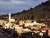
| Virginia City Historic District Virginia City Historic District (Virginia City, Montana) The Virginia City Historic District is a National Historic Landmark District encompassing Virginia City, Montana, United States. Designated in 1966, the district includes over two hundred nineteenth-century buildings, representing the site of a major gold strike and the capital of Montana for ten... |
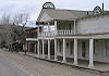 |
Virginia City Virginia City, Montana Virginia City is a town in and the county seat of Madison County, Montana, United States. In 1961, the town and the surrounding area was designated a National Historic Landmark District, the Virginia City Historic District... 45°17′37"N 111°56′41"W |
Madison Madison County, Montana -National protected areas:*Beaverhead National Forest *Deerlodge National Forest *Gallatin National Forest -Demographics:As of the census of 2000, there were 6,851 people, 2,956 households, and 1,921 families residing in the county. The population density was 2 people per square mile... |
More than 200 historic 19th century building Building In architecture, construction, engineering, real estate development and technology the word building may refer to one of the following:... s remain in this 1860s mining Mining Mining is the extraction of valuable minerals or other geological materials from the earth, from an ore body, vein or seam. The term also includes the removal of soil. Materials recovered by mining include base metals, precious metals, iron, uranium, coal, diamonds, limestone, oil shale, rock... town Town A town is a human settlement larger than a village but smaller than a city. The size a settlement must be in order to be called a "town" varies considerably in different parts of the world, so that, for example, many American "small towns" seem to British people to be no more than villages, while... ; it also served as the Montana Montana Montana is a state in the Western United States. The western third of Montana contains numerous mountain ranges. Smaller, "island ranges" are found in the central third of the state, for a total of 77 named ranges of the Rocky Mountains. This geographical fact is reflected in the state's name,... Territorial Capitol during the same period. |
||
| Burton K. Wheeler House Burton K. Wheeler House Burton K. Wheeler House, in Butte, Montana, was a home of politician Burton K. Wheeler.It was declared a National Historic Landmark in 1976.It is located at 1232 East Second Street, in Butte.... |
Butte Butte, Montana Butte is a city in Montana and the county seat of Silver Bow County, United States. In 1977, the city and county governments consolidated to form the sole entity of Butte-Silver Bow. As of the 2010 census, Butte's population was 34,200... 46.00565°N 112.52151°W |
Silver Bow Silver Bow County, Montana -National protected areas:*Beaverhead National Forest *Deerlodge National Forest -Demographics:As of the census of 2000, there were 34,606 people, 14,432 households, and 8,933 families residing in the county. The population density was 48 people per square mile . There were 16,176 housing units at... |
Former residence of noted Montana Senator Burton K. Wheeler Burton K. Wheeler Burton Kendall Wheeler was an American politician of the Democratic Party and a United States Senator from 1923 until 1947.-Early life:... . |
|||
| Wolf Mountains Battlefield-Where Big Crow walked Back and Forth | Birney Birney, Montana Birney is a census-designated place in Rosebud County, Montana, United States. The population was 108 at the 2000 census.-Geography:Birney is located at .... 45.28823°N 106.58146°W |
Rosebud Rosebud County, Montana -Demographics:As of the census of 2000, there were 9,383 people, 3,307 households, and 2,417 families residing in the county. The population density was 2 people per square mile . There were 3,912 housing units at an average density of 1 per square mile... |
Site of the Battle of Wolf Mountain Battle of Wolf Mountain The Battle of Wolf Mountain, also known the Battle of the Wolf Mountains, Miles's Battle on the Tongue River, and the Battle of the Butte, occurred January 8, 1877 in the Montana Territory between the United States Army and a force of Lakota Sioux and Northern Cheyenne during the Great Sioux War of... . |
|||
See also
- Historic preservationHistoric preservationHistoric preservation is an endeavor that seeks to preserve, conserve and protect buildings, objects, landscapes or other artifacts of historical significance...
- History of MontanaHistory of Montana-Indigenous peoples :Archeological evidence has shown indigenous peoples lived in the area for thousands of years. For example, rock art in Pictograph Cave six miles south of Billings has been dated, showing human presence in the area more than 2,100 years ago. Most indigenous people of the...
- National Register of Historic PlacesNational Register of Historic PlacesThe National Register of Historic Places is the United States government's official list of districts, sites, buildings, structures, and objects deemed worthy of preservation...
- List of Registered Historic Places in Montana
External links
- National Historic Landmark Program at the National Park ServiceNational Park ServiceThe National Park Service is the U.S. federal agency that manages all national parks, many national monuments, and other conservation and historical properties with various title designations...
- Lists of National Historic Landmarks