
Missouri Headwaters State Park
Encyclopedia
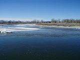
Missouri Headwaters State Park is a Montana state park that marks the official start of the Missouri River
. It includes the Three Forks of the Missouri National Historic Landmark
.
It is located near Three Forks, Montana
at an elevation of 4045 feet (1,232.9 m).
The Missouri starts at the confluence of the Jefferson River
and Madison River
. It is joined about 0.6 mile down stream (northeast) by the Gallatin River
.
Lewis and Clark visited the site on July 28, 1805. Meriwether Lewis
in his journal entry wrote:
The Lewis and Clark decision not to call the Jefferson the Missouri has spurred debate over what is the longest river in North America since the Missouri and Mississippi are nearly identical in length. The Missouri traditionally had been called the longest river in North America. However, 72 miles of it have been trimmed off in re-channeling its streambedmainly for the many hydroelectric power plants in the region so that it is now sometimes referred as second to the Mississippi in terms of length. If the Jefferson were included in the Missouri length, it would technically still be considered the longest river by the USGS experts.
The utmost headwaters of the Missouri are subject to debate but both locations ultimately drain into the Jefferson. Lewis on August 12, 1805 said he visited the headwaters on Trail Creek just above Lemhi Pass
on the Continental Divide
in the Beaverhead Mountains at around 8,600 feet which he described:
However in 1888 Jacob V. Brower
, who had championed turning the headwaters of the Mississippi River into a Minnesota state park, visited another site which today is believed to be the furthest point on the Missouri—now called Brower's Spring
. Brower published his finding in 1896 in "The Missouri: It's Utmost Source."
The site of Brower's Spring at around 8,800 feet in the Centennial Mountains
. The site now commemorated by a rock pile at the source of Hellroaring Creek which flows into Red Rock River and then into Clark Canyon Reservoir where it joins the Beaverhead then the Big Hole River before ultimately hooking up with the Jefferson.
Missouri River
The Missouri River flows through the central United States, and is a tributary of the Mississippi River. It is the longest river in North America and drains the third largest area, though only the thirteenth largest by discharge. The Missouri's watershed encompasses most of the American Great...
. It includes the Three Forks of the Missouri National Historic Landmark
National Historic Landmark
A National Historic Landmark is a building, site, structure, object, or district, that is officially recognized by the United States government for its historical significance...
.
It is located near Three Forks, Montana
Three Forks, Montana
Three Forks is a city in Gallatin County, Montana, United States and is located within the watershed valley system of both the Missouri and Mississippi rivers drainage basins — and is historically considered the birthplace or start of the Missouri River. The population was 1,728 at the 2000 census...
at an elevation of 4045 feet (1,232.9 m).
The Missouri starts at the confluence of the Jefferson River
Jefferson River
The Jefferson River is a tributary of the Missouri River, approximately long, in the U.S. state of Montana. The Jefferson River and the Madison River form the official beginning of the Missouri at Missouri Headwaters State Park near Three Forks...
and Madison River
Madison River
The Madison River is a headwater tributary of the Missouri River, approximately 183 miles long, in Wyoming and Montana. Its confluence with the Jefferson and Gallatin rivers near Three Forks, Montana form the Missouri River....
. It is joined about 0.6 mile down stream (northeast) by the Gallatin River
Gallatin River
The Gallatin River is a tributary of the Missouri River, approximately 120 mi , in the U.S. states of Wyoming and Montana...
.
Lewis and Clark visited the site on July 28, 1805. Meriwether Lewis
Meriwether Lewis
Meriwether Lewis was an American explorer, soldier, and public administrator, best known for his role as the leader of the Lewis and Clark Expedition also known as the Corps of Discovery, with William Clark...
in his journal entry wrote:
- Both Capt. C. and myself corresponded in opinon with rispect(sic) to the impropriety of calling either of these [three] streams the Missouri and accordingly agreed to name them after the President of the United States and the Secretaries of the Treasury and state.
The Lewis and Clark decision not to call the Jefferson the Missouri has spurred debate over what is the longest river in North America since the Missouri and Mississippi are nearly identical in length. The Missouri traditionally had been called the longest river in North America. However, 72 miles of it have been trimmed off in re-channeling its streambedmainly for the many hydroelectric power plants in the region so that it is now sometimes referred as second to the Mississippi in terms of length. If the Jefferson were included in the Missouri length, it would technically still be considered the longest river by the USGS experts.
The utmost headwaters of the Missouri are subject to debate but both locations ultimately drain into the Jefferson. Lewis on August 12, 1805 said he visited the headwaters on Trail Creek just above Lemhi Pass
Lemhi Pass
Lemhi Pass is a high mountain pass in the Beaverhead Mountains, part of the Bitterroot Range in the Rocky Mountains The pass lies on the Montana-Idaho border on the continental divide, at an elevation of 7373 feet above sea level.-History:...
on the Continental Divide
Continental Divide
The Continental Divide of the Americas, or merely the Continental Gulf of Division or Great Divide, is the name given to the principal, and largely mountainous, hydrological divide of the Americas that separates the watersheds that drain into the Pacific Ocean from those river systems that drain...
in the Beaverhead Mountains at around 8,600 feet which he described:
- the most distant fountain of the waters of the mighty Missouri in surch(sic) of which we have spent so many toilsome days and wristless(sic) nights.
However in 1888 Jacob V. Brower
Jacob V. Brower
Jacob Vandenberg Brower was a prolific writer of the Upper Midwest region of the United States who championed the location and protection of the utmost headwaters of the Mississippi and Missouri rivers.He was born in Michigan and moved to Minnesota...
, who had championed turning the headwaters of the Mississippi River into a Minnesota state park, visited another site which today is believed to be the furthest point on the Missouri—now called Brower's Spring
Brower's Spring
Brower's Spring is a spring in the Centennial Mountains of Montana that is believed to be the ultimate headwaters of the Missouri River.The spring is named for Jacob V. Brower who in 1896 declared it to be the source of the Missouri in The Missouri: Its Utmost Source...
. Brower published his finding in 1896 in "The Missouri: It's Utmost Source."
The site of Brower's Spring at around 8,800 feet in the Centennial Mountains
Centennial Mountains
The Centennial Mountains are the southernmost sub-range of the Bitterroot Range in the U.S. states of Idaho and Montana. The Centennial Mountains include the Western and Eastern Centennial Mountains...
. The site now commemorated by a rock pile at the source of Hellroaring Creek which flows into Red Rock River and then into Clark Canyon Reservoir where it joins the Beaverhead then the Big Hole River before ultimately hooking up with the Jefferson.