

Leyte Island
Encyclopedia
Island
An island or isle is any piece of sub-continental land that is surrounded by water. Very small islands such as emergent land features on atolls can be called islets, cays or keys. An island in a river or lake may be called an eyot , or holm...
in the Visayas
Visayas
The Visayas or Visayan Islands and locally known as Kabisay-an gid, is one of the three principal geographical divisions of the Philippines, along with Mindanao and Luzon. It consists of several islands, primarily surrounding the Visayan Sea, although the Visayas are considered the northeast...
group of the Philippines
Philippines
The Philippines , officially known as the Republic of the Philippines , is a country in Southeast Asia in the western Pacific Ocean. To its north across the Luzon Strait lies Taiwan. West across the South China Sea sits Vietnam...
.
The island measures about 180 km (110 mi) north-south and about 65 km (40 mi) at its widest point. In the north it nearly joins Samar
Samar Island
Samar is an island in the Visayas, within the central Philippines. The island is divided into three provinces: Samar province, Northern Samar, and Eastern Samar. These three provinces, along with the provinces on the nearby islands of Leyte and Biliran are part of the Eastern Visayas region...
, separated by the San Juanico Strait
San Juanico Strait
San Juanico Strait is a narrow strait in the Philippines. It separates the islands of Samar and Leyte. At its narrowest point, the strait is only wide, said to be the narrowest strait in the world. It is crossed by the San Juanico Bridge....
, which becomes as narrow as 2 km (1.2 mi) in some places. The island province of Biliran
Biliran
In 1945 liberated by the Philippine Commonwealth forces of the 9th Infantry Division of the Philippine Commonwealth Army was landed in Biliran with the local guerrilla forces by the attack of the Japanese troops from the island during the Battle of Biliran during World War II.-Conversion:On April...
is also to the north of Leyte and is joined to Leyte island by a bridge across the narrow Biliran Strait. To the south Leyte is separated from Mindanao
Mindanao
Mindanao is the second largest and easternmost island in the Philippines. It is also the name of one of the three island groups in the country, which consists of the island of Mindanao and smaller surrounding islands. The other two are Luzon and the Visayas. The island of Mindanao is called The...
by the Surigao Strait
Surigao Strait
Surigao Strait is a body of water in the Philippines located between the islands of Mindanao and Leyte. This strait connects the Bohol Sea with Leyte Gulf and is regularly crossed by ferries that transport goods and people between Visayas and Mindanao...
. To the east, Leyte is somewhat "set back" from the Philippine Sea
Philippine Sea
The Philippine Sea is a marginal sea east and north of the Philippines occupying an estimated surface area of 2 million mi² on the western part of the North Pacific Ocean...
of the Pacific Ocean
Pacific Ocean
The Pacific Ocean is the largest of the Earth's oceanic divisions. It extends from the Arctic in the north to the Southern Ocean in the south, bounded by Asia and Australia in the west, and the Americas in the east.At 165.2 million square kilometres in area, this largest division of the World...
, Samar to the northeast and Dinagat
Dinagat Island
' is a province in the Philippines, located on the south side of Leyte Gulf. Leyte is to its west, across Surigao Strait, and Mindanao is to its south...
to the southeast forming the Leyte Gulf
Leyte Gulf
Leyte Gulf is a body of water immediately east of the island of Leyte in the Philippines, adjoining the Philippine Sea of the Pacific Ocean, at . The Gulf is bounded on the north by the island of Samar, which is separated from Leyte on the west by the narrow San Juanico Strait, and on the south by...
. To the west are Cebu
Cebu Island
Cebu is an island of the Philippines. It is the main island of Cebu Province at the center of the Visayan Islands, south of Manila.It lies to the east of Negros Island; to the east is Leyte and to the southeast is Bohol Island. It is flanked on both sides by the Cebu Strait and Tañon Strait...
and Bohol
Bohol
Bohol is an island province of the Philippines located in the Central Visayas region, consisting of Bohol Island and 75 minor surrounding islands. Its capital is Tagbilaran City. With a land area of and a coastline long, Bohol is the tenth largest island of the Philippines...
.
Leyte is mostly heavily forested and mountainous, but the Leyte Valley in the northeast has much agriculture.
Politically, the island is divided into two provinces
Provinces of the Philippines
The Provinces of the Philippines are the primary political and administrative divisions of the Philippines. There are 80 provinces at present, further subdivided into component cities and municipalities. The National Capital Region, as well as independent cities, are autonomous from any provincial...
: (Northern) Leyte and Southern Leyte
Southern Leyte
Southern Leyte is a province of the Philippines located in the Eastern Visayas region. Maasin City is the capital of the province. Southern Leyte was once a sub-province of Leyte before it was divided from the latter...
. Territorially, Southern Leyte Province includes the island of Panaon
Panaon Island
Panaon Island,Panaon Island is a small island in the Philippines, in the province of Southern Leyte. It lies south of Leyte, separated from Dinagat to the east, and Mindanao to the southeast by Surigao Strait. The Mindanao Sea lies to the southwest....
to its south. Biliran Island
Biliran Island
Biliran is a volcanic island in the central Philippines. It is one of the active volcanoes in the Philippines.*Classification: Active*Current Summit Activities: Solfataric*Province: Biliran Region VIII*Nearby Cities/Towns:...
, to the north of Leyte Island, was formerly a sub-province of Leyte, and is now a separate province, Biliran Province.
The chief cities of Leyte are Tacloban City
Tacloban City
The City of Tacloban is a port city approximately 360 miles southeast of Manila. It is the first in Eastern Visayas to be classified as a Highly Urbanized City. It is the capital of the Philippine province of Leyte and is the largest city in terms of population in Eastern Visayas...
, on the eastern shore at the northwest corner of Leyte Gulf, and Ormoc City
Ormoc City
The City of Ormoc is a 1st class city in the province of Leyte, Philippines. The city's name is derived from ogmok, an old Visayan term for lowland or depressed plain. It is the first non-provincial city of the Philippines. According to the 2007 census, it has a population of 177,524 people...
, on the west coast.
Leyte today is notable for the geothermal
Geothermal power
Geothermal energy is thermal energy generated and stored in the Earth. Thermal energy is the energy that determines the temperature of matter. Earth's geothermal energy originates from the original formation of the planet and from radioactive decay of minerals...
electric power plants near Ormoc.
However, Leyte is most famous for its role in the reconquest of the Philippines
Philippines
The Philippines , officially known as the Republic of the Philippines , is a country in Southeast Asia in the western Pacific Ocean. To its north across the Luzon Strait lies Taiwan. West across the South China Sea sits Vietnam...
in World War II
World War II
World War II, or the Second World War , was a global conflict lasting from 1939 to 1945, involving most of the world's nations—including all of the great powers—eventually forming two opposing military alliances: the Allies and the Axis...
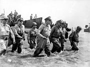
. On 20 October 1944, General Douglas MacArthur
Douglas MacArthur
General of the Army Douglas MacArthur was an American general and field marshal of the Philippine Army. He was a Chief of Staff of the United States Army during the 1930s and played a prominent role in the Pacific theater during World War II. He received the Medal of Honor for his service in the...
waded ashore on Leyte, saying "I have returned". However, the Japan
Japan
Japan is an island nation in East Asia. Located in the Pacific Ocean, it lies to the east of the Sea of Japan, China, North Korea, South Korea and Russia, stretching from the Sea of Okhotsk in the north to the East China Sea and Taiwan in the south...
ese did not give up so easily, as the ensuing Battle of Leyte
Battle of Leyte
The Battle of Leyte in the Pacific campaign of World War II was the invasion and conquest of the island of Leyte in the Philippines by American and Filipino guerrilla forces under the command of General Douglas MacArthur, who fought against the Imperial Japanese Army in the Philippines led by...
proved, and convergence of naval forces resulted in the four-day Battle of Leyte Gulf
Battle of Leyte Gulf
The Battle of Leyte Gulf, also called the "Battles for Leyte Gulf", and formerly known as the "Second Battle of the Philippine Sea", is generally considered to be the largest naval battle of World War II and, by some criteria, possibly the largest naval battle in history.It was fought in waters...
, the largest naval battle in history.
Areas of interest
The Leyte Provincial Capitol is the seat of the provincial government where historic viewing of a mural depicting the First Mass of Limasawa in the Orient and the landing of Gen. Douglas MacArthurDouglas MacArthur
General of the Army Douglas MacArthur was an American general and field marshal of the Philippine Army. He was a Chief of Staff of the United States Army during the 1930s and played a prominent role in the Pacific theater during World War II. He received the Medal of Honor for his service in the...
can be done.
The Leyte Landing Memorial in Red Beach, Palo
Palo, Leyte
Palo is a 3rd class municipality in the province of Leyte, Philippines. According to the 2000 census, it has a population of 47,982 people in 9,272 households.-Barangays:Palo is politically subdivided into 33 barangays.* Anahaway* Arado* Baras...
, marks the spot where American liberation forces landed it also has a lagoon where the life-size statues of Gen. McArthur and his fleet stands.
Lake Danao is a violin-shaped lake hemmed by cloud-capped mountain ranges. It is a hunter’s paradise where wild animals roam the surrounding forests. It is also said to be the home of a giant eel.
Calanggaman Island in Palompon, Leyte is a virgin island with pure white side. It has two long sandbars. The ecological atmosphere of the island had been preserved by the municipality.
The Sto. Nino Shrine and Heritage Museum boasts the painting of the 14 station of the cross done by Filipino artists and a bas-relief of the legend of the first Filipino man and woman (Malakas and Maganda).
The San Juanico Bridge is the longest and the most beautifully designed bridge in the Philippines. It features the picturesque San Juanico Strait with a thousand whirlpools, lovely islets and view.
Leyte Island is the birthplace of the Tinikling
Tinikling
The tinikling is one of the most popular and well-known of traditional Philippine dances. The tinikling is a pre-Spanish dance from the Philippines that involves two people beating, tapping, and sliding bamboo poles on the ground and against each other in coordination with one or more dancers who...
dance, which is very popular throughout the Philippines.
In popular culture
The Japanese film Nobi ("Fires on the Plain")Fires on the Plain (film)
is a 1959 Japanese war film directed by Kon Ichikawa, starring Eiji Funakoshi. The screenplay, written by, Natto Wada, is based on the novel Nobi by Shohei Ooka, translated as Fires on the Plain. It initially received mixed reviews from both Japanese and international critics concerning its...
is set on Leyte in 1945 (but was filmed in Japan).