
Lewis Range
Encyclopedia
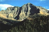
The Lewis Range is a mountain range
located in the Rocky Mountains
of northern Montana
, U.S. and extreme southern Alberta
, Canada
. Formed by the Lewis Overthrust
beginning 170 million years ago, an enormous slab of Precambrian
rocks 3 miles (4.8 km) thick, 50 miles (80.5 km) wide and 160 miles (257.5 km) long faulted and slid over newer rocks of the Cretaceous
period. In this relatively rare occurrence, older rocks are now positioned above newer ones.
The Lewis Range is within Waterton Lakes National Park
in Canada, and in Glacier National Park and the Bob Marshall Wilderness Complex
located in Flathead
and Lewis and Clark National Forest
s in Montana. The Continental Divide
spans much of the uppermost sections of the range. Major peaks in the range include Mount Cleveland
(10,466 ft/3,185 m), which is the highest peak in the range and in Glacier National Park. Other prominent peaks include Mount Stimson
(10,142 ft/3,091 m), Mount Jackson
(10,052 ft/3,064 m), Mount Siyeh
(10,014 ft/3,052 m), Going to the Sun Mountain, (9,642 ft/2,939 m) and the isolated Chief Mountain
(9,080 ft/2,768 m). The Chinese wall in the Bob Marshall Wilderness
is a 1,000 foot (304 m) high feature that runs for 40 miles (64.4 km). Major passes include Marias Pass
and Logan Pass
which bisects Glacier National Park east to west.
Mountain range
A mountain range is a single, large mass consisting of a succession of mountains or narrowly spaced mountain ridges, with or without peaks, closely related in position, direction, formation, and age; a component part of a mountain system or of a mountain chain...
located in the Rocky Mountains
Rocky Mountains
The Rocky Mountains are a major mountain range in western North America. The Rocky Mountains stretch more than from the northernmost part of British Columbia, in western Canada, to New Mexico, in the southwestern United States...
of northern Montana
Montana
Montana is a state in the Western United States. The western third of Montana contains numerous mountain ranges. Smaller, "island ranges" are found in the central third of the state, for a total of 77 named ranges of the Rocky Mountains. This geographical fact is reflected in the state's name,...
, U.S. and extreme southern Alberta
Alberta
Alberta is a province of Canada. It had an estimated population of 3.7 million in 2010 making it the most populous of Canada's three prairie provinces...
, Canada
Canada
Canada is a North American country consisting of ten provinces and three territories. Located in the northern part of the continent, it extends from the Atlantic Ocean in the east to the Pacific Ocean in the west, and northward into the Arctic Ocean...
. Formed by the Lewis Overthrust
Lewis Overthrust
The Lewis Overthrust is a geologic fault structure of the Rocky Mountains within Glacier National Park in Montana, USA and Waterton Lakes National Park in Alberta, Canada, as well as into Lewis and Clark National Forest. It provides scientific insight into geologic processes happening in other...
beginning 170 million years ago, an enormous slab of Precambrian
Precambrian
The Precambrian is the name which describes the large span of time in Earth's history before the current Phanerozoic Eon, and is a Supereon divided into several eons of the geologic time scale...
rocks 3 miles (4.8 km) thick, 50 miles (80.5 km) wide and 160 miles (257.5 km) long faulted and slid over newer rocks of the Cretaceous
Cretaceous
The Cretaceous , derived from the Latin "creta" , usually abbreviated K for its German translation Kreide , is a geologic period and system from circa to million years ago. In the geologic timescale, the Cretaceous follows the Jurassic period and is followed by the Paleogene period of the...
period. In this relatively rare occurrence, older rocks are now positioned above newer ones.
The Lewis Range is within Waterton Lakes National Park
Waterton Lakes National Park
Waterton Lakes National Park is a national park located in the southwest corner of Alberta, Canada, and borders Glacier National Park in Montana, USA. Waterton was Canada's fourth national park, formed in 1895 and named after Waterton Lake, in turn after the Victorian naturalist and conservationist...
in Canada, and in Glacier National Park and the Bob Marshall Wilderness Complex
Bob Marshall Wilderness Complex
The Bob Marshall Wilderness Complex consists of three wilderness areas, all within the U.S. state of Montana totalling over 1.5 million acres . The largest wilderness area is the Bob Marshall consisting of 1 million acres...
located in Flathead
Flathead National Forest
The Flathead National Forest is a national forest in the western part of the U.S. state of Montana. The forest covers of which about 1 million acres is designated wilderness. It is named after the Flathead Indians who lived in the area. The forest is located in the Rocky Mountains with elevations...
and Lewis and Clark National Forest
Lewis and Clark National Forest
Lewis and Clark National Forest is located in west central Montana, United States. Spanning , the forest is managed as two separate zones. The eastern sections, under the Jefferson Division, is a mixture of grass and shrublands dotted with "island" pockets of forested areas. Here, cattle leases to...
s in Montana. The Continental Divide
Continental Divide
The Continental Divide of the Americas, or merely the Continental Gulf of Division or Great Divide, is the name given to the principal, and largely mountainous, hydrological divide of the Americas that separates the watersheds that drain into the Pacific Ocean from those river systems that drain...
spans much of the uppermost sections of the range. Major peaks in the range include Mount Cleveland
Mount Cleveland (Montana)
Mount Cleveland is the highest mountain in Glacier National Park, located in Montana, United States. It is also the highest point in the Lewis Range, which spans part of the northern portion of the Park and extends into Canada...
(10,466 ft/3,185 m), which is the highest peak in the range and in Glacier National Park. Other prominent peaks include Mount Stimson
Mount Stimson
Mount Stimson is the second highest peak in Glacier National Park, located in Montana, United States. It is part of the Lewis Range, which spans much of the park. It is located in the remote southwestern portion of the park, approximately west of the Continental Divide and southeast of Lake...
(10,142 ft/3,091 m), Mount Jackson
Mount Jackson (Montana)
Mount Jackson is located in the Lewis Range, Glacier National Park in the U.S. state of Montana. Mount Jackson is the fourth tallest mountain in Glacier National Park and it is situated on the Continental Divide. Both the mountain and its namesake Jackson Glacier are easily seen from the...
(10,052 ft/3,064 m), Mount Siyeh
Mount Siyeh
Mount Siyeh, with a height of , is the fifth tallest and one of six peaks over in Glacier National Park, Montana, United States. Mount Siyeh was named after a Blackfoot Indian, Sai-yeh, whose name means "Crazy Dog" or "Mad Wolf."...
(10,014 ft/3,052 m), Going to the Sun Mountain, (9,642 ft/2,939 m) and the isolated Chief Mountain
Chief Mountain
Chief Mountain is located in the U.S. state of Montana on the eastern border of Glacier National Park and the Blackfeet Indian Reservation...
(9,080 ft/2,768 m). The Chinese wall in the Bob Marshall Wilderness
Bob Marshall Wilderness
The Bob Marshall Wilderness is a wilderness area in Flathead National Forest of western Montana in the United States. It is named after Bob Marshall , an early forester, conservationist, and co-founder of The Wilderness Society. The Bob Marshall Wilderness extends for 60 miles along the...
is a 1,000 foot (304 m) high feature that runs for 40 miles (64.4 km). Major passes include Marias Pass
Marias Pass
Marias Pass is a high mountain pass near Glacier National Park in northwestern Montana in the United States.The pass traverses the continental divide in the Lewis Range, along the boundary between the Lewis and Clark National Forest and the Flathead National Forest...
and Logan Pass
Logan Pass
Logan Pass is located along the Continental Divide in Glacier National Park, in the U.S. state of Montana. It is the highest point on the Going-to-the-Sun Road....
which bisects Glacier National Park east to west.
See also
- Mountains and mountain ranges of Glacier National Park (U.S.)Mountains and mountain ranges of Glacier National Park (U.S.)Mountains in Glacier National Park are part of the Rocky Mountains. There are at least 150 named mountain peaks over in Glacier in three mountain ranges--the Clark Range, Lewis Range, Livingston Range. Mount Cleveland el....
- List of mountain ranges in Montana