

Leeds Country Way
Encyclopedia
The Leeds Country Way is a circular long-distance footpath
of 62 miles (99 km) around Leeds
, West Yorkshire
, England
. It is never more than 7 miles (11 km) from Leeds City Square
, but is mainly rural with extensive views in the outlying areas of the Leeds metropolitan district
. It follows public Rights of Way including footpaths, bridleways and minor lanes, with a few short sections along roads.
. The Leeds Country Way was realigned in 2006, using a route devised by Bob Brewster, to bring it entirely within the boundary of the Leeds metropolitan district
(previously it crossed the boundary into Wakefield
), and the path was officially relaunched on 26 September 2006 with a revised set of map leaflets (see external links) and improved waymarking.
from the A660 road
at Golden Acre Park
, divided into parts and sections which correspond with the official map leaflets.
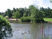 Section 1: The path crosses Golden Acre Park and passes the Yorkshire Wildlife Trust
's Adel Dam Nature Reserve, following the route of the Meanwood Valley Trail
. It coincides briefly with the Leeds link to the Dales Way
north of Eccup Reservoir
, before crossing the Ebor Way
and entering the Harewood Estate
. Here there is a glimpse of what looks like a small village, not marked on any map, but which is actually the set for the TV series Emmerdale
. Walkers may also see red kite
s which have been successfully reintroduced in this area.
Section 2: After crossing the A61
, the way passes north of Wike
and reaches the village of Bardsey
with its Anglo-Saxon church tower and the Bingley Arms public house
, which claims to be the oldest in England. The way turns south, crossing the A58
, to Scarcroft
.
Section 3: The path continues through Thorner
, crossing the A64
before entering Barwick-in-Elmet
with England's tallest maypole
, a Norman motte
and an Iron Age
fort.
 Section 1: From Barwick the way passes the southern corner of Scholes
, then crosses the M1 motorway
and enters Garforth
.
Section 2: It leaves Garforth along the disused Garforth-Kippax railway line (part of the North Eastern Railway
and earlier the Leeds, Castleford and Pontefract Junction Railway), then approaches Swillington
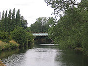
and passes Little Preston Old Hall. It skirts St Aidan's Country Park, and crosses the River Aire
at Swillington Bridge. The path follows the river downstream, past the marina at Fleet Bridge.
Section 3: The path continues along the river, here forming the Aire and Calder Navigation
, to Mickletown
, and then turns south to Methley
. It swings eastward, crosses the A642
and continues to Carlton , heart of the West Yorkshire Rhubarb Triangle
.
 Section 1: From Carlton the path crosses fields before briefly joining the A61
and recrossing the M1
south of Robin Hood
. It turns south across the M62
, follows the valley of Dolphin Beck, and reaches East Ardsley
on the A650.
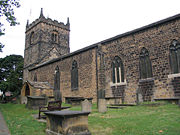
Section 2: From here the path skirts south of West Ardsley
, and reaches Woodkirk
with its historic church, on the A653. It passes the ruins of Howley Hall (built 1590 for Sir John Savile) before dropping down to reach Scotchman Lane.
Section 3: A track through Birkby Brow Wood, just inside the Leeds-Kirklees
boundary, leads to the A643
, which is followed to recross the M62. The path's longest section of road walking follows the A650 through Gildersome
, then a series of field paths leads to Cockersdale
, on the A58
near Tong
.
 Section 1: The path follows the valley of Cockersdale, and then goes along Tong
Beck, below Fulneck Moravian Settlement
, skirting the south of Pudsey
. At this point Tong Beck forms the Leeds-Bradford
boundary. The path crosses the Leeds to Bradford railway and meets the busy A647 at Thornbury
.
Section 2: Passing playing fields and old quarries, the path crosses the Woodhall Hills and follows Fagley Beck to cross the Leeds and Liverpool Canal
and the River Aire
at Apperley Bridge
, then follows the river past Woodhouse Grove School
before climbing up to meet the A65
south of Rawdon.
Section 3: From here the path skirts Horsforth
, follows for a time the southern boundary of Leeds Bradford International Airport
, and goes round the northern edge of Cookridge
, before crossing Breary Marsh Local Nature Reserve
to return to Golden Acre Park
.
, going clockwise. These divide it into four parts each split into three sections, but walkers can choose to divide it in various ways as there are many bus routes and several railway stations (Woodlesford
, Garforth
, New Pudsey
and Horsforth
) on or near the path. West Yorkshire Metro
provides information about bus routes serving the path and train services in the area.
The Ordnance Survey
maps covering the route are:
The route is waymarked with an owl symbol, taken from the Leeds coat of arms
.
The original route of the path is used for an annual trail running
relay race
organised by Kippax Harriers. Teams of twelve, with two runners taking each of six sections, complete the route in about seven hours.
Each downloadable map/guide covers approx 15 miles and is split into 3 sections of approx 5 miles each. Each map/guide prints out to two A4 sheets of paper.
Long-distance trail
Long-distance trails are the longer recreational trails mainly through rural areas, used for non-motorised recreational travelling ....
of 62 miles (99 km) around Leeds
Leeds
Leeds is a city and metropolitan borough in West Yorkshire, England. In 2001 Leeds' main urban subdivision had a population of 443,247, while the entire city has a population of 798,800 , making it the 30th-most populous city in the European Union.Leeds is the cultural, financial and commercial...
, West Yorkshire
West Yorkshire
West Yorkshire is a metropolitan county within the Yorkshire and the Humber region of England with a population of 2.2 million. West Yorkshire came into existence as a metropolitan county in 1974 after the passage of the Local Government Act 1972....
, England
England
England is a country that is part of the United Kingdom. It shares land borders with Scotland to the north and Wales to the west; the Irish Sea is to the north west, the Celtic Sea to the south west, with the North Sea to the east and the English Channel to the south separating it from continental...
. It is never more than 7 miles (11 km) from Leeds City Square
Leeds City Square
City Square is a paved open area in Leeds city centre in West Yorkshire, England.In 1897, the Leeds city council of the time wanted to improve the open space near to the Post Office and in 1899 work was completed. The city square was enhanced with the erection of statues, the grandest being the...
, but is mainly rural with extensive views in the outlying areas of the Leeds metropolitan district
City of Leeds
The City of Leeds is a local government district of West Yorkshire, England, governed by Leeds City Council, with the status of a city and metropolitan borough. The metropolitan district includes Leeds and the towns of Farsley, Garforth, Guiseley, Horsforth, Morley, Otley, Pudsey, Rothwell,...
. It follows public Rights of Way including footpaths, bridleways and minor lanes, with a few short sections along roads.
History
A route was first devised by Fred Andrews of the Ramblers Association, and then developed by West Yorkshire County Council in the early 1980s. This council was abolished in 1986, and the path is now under the care of the Countryside section of Leeds City CouncilLeeds City Council
Leeds City Council is the local authority for the City of Leeds metropolitan district of West Yorkshire, England.-History:The city council was established in 1974, with the first elections being held in advance in 1973...
. The Leeds Country Way was realigned in 2006, using a route devised by Bob Brewster, to bring it entirely within the boundary of the Leeds metropolitan district
City of Leeds
The City of Leeds is a local government district of West Yorkshire, England, governed by Leeds City Council, with the status of a city and metropolitan borough. The metropolitan district includes Leeds and the towns of Farsley, Garforth, Guiseley, Horsforth, Morley, Otley, Pudsey, Rothwell,...
(previously it crossed the boundary into Wakefield
City of Wakefield
The City of Wakefield is a local government district of West Yorkshire, England, with the status of a city and metropolitan borough. Wakefield is the district's administrative centre. The district includes the "Five Towns" of Normanton, Pontefract, Featherstone, Castleford and Knottingley. Other...
), and the path was officially relaunched on 26 September 2006 with a revised set of map leaflets (see external links) and improved waymarking.
Route
The path is waymarked in both directions and can be started at any point, but is described here clockwiseClockwise
Circular motion can occur in two possible directions. A clockwise motion is one that proceeds in the same direction as a clock's hands: from the top to the right, then down and then to the left, and back to the top...
from the A660 road
A660 road
The A660 is a major road in West Yorkshire, England that runs from Leeds to Burley-in-Wharfedale where it meets the A65. The A660 is approximately long, and crosses the watershed from Airedale to lower Wharfedale...
at Golden Acre Park
Golden Acre Park
Golden Acre Park is a public park between Adel and Bramhope, Leeds, West Yorkshire, England , administered by Leeds City Council. It is on the A660 Otley Road and covers an area of ....
, divided into parts and sections which correspond with the official map leaflets.
Part 1: Golden Acre to Barwick-in-Elmet
Yorkshire Wildlife Trust
The Yorkshire Wildlife Trust is a wildlife trust covering the traditional county of Yorkshire, England.The Trust is part of the UK-wide partnership of 47 Wildlife Trusts.It was formed in 1946, as the Yorkshire Naturalists’ Trust, essentially to preserve its first nature reserve Askham Bog on the...
's Adel Dam Nature Reserve, following the route of the Meanwood Valley Trail
Meanwood Valley Trail
The Meanwood Valley Trail is a waymarked footpath and annual footrace route in Leeds, West Yorkshire, England. It runs for a distance of from the statue of Henry Rowland Marsden, 1878, on Woodhouse Moor, close to the University of Leeds, through Headingley, Meanwood and Adel to Breary Marsh,...
. It coincides briefly with the Leeds link to the Dales Way
Dales Way
The Dales Way is an 84-mile Long Distance Footpath in Northern England, from Ilkley, West Yorkshire to Bowness-on-Windermere, Cumbria....
north of Eccup Reservoir
Eccup reservoir
Eccup reservoir is a reservoir in Alwoodley, a suburb of Leeds, West Yorkshire, England. It was first constructed in 1843, and later expanded. The reservoir and the surrounding woodlands are both Sites of Special Scientific Interest. The open water area is 91.3 hectares, making it largest area of...
, before crossing the Ebor Way
Ebor Way
The Ebor Way is a 70 mile long-distance footpath from Helmsley, North Yorkshire to Ilkley, West Yorkshire, England. It takes its name from Eboracum, the Roman name for York....
and entering the Harewood Estate
Harewood House
Harewood House is a country house located in Harewood , near Leeds, West Yorkshire, England. It is a member of Treasure Houses of England, a marketing consortium for nine of the foremost stately homes in England...
. Here there is a glimpse of what looks like a small village, not marked on any map, but which is actually the set for the TV series Emmerdale
Emmerdale
Emmerdale, is a long-running British soap opera set in Emmerdale , a fictional village in the Yorkshire Dales. Created by Kevin Laffan, Emmerdale was first broadcast on 16 October 1972...
. Walkers may also see red kite
Red Kite
The Red Kite is a medium-large bird of prey in the family Accipitridae, which also includes many other diurnal raptors such as eagles, buzzards, and harriers. The species is currently endemic to the Western Palearctic region in Europe and northwest Africa, though formerly also occurred just...
s which have been successfully reintroduced in this area.
Section 2: After crossing the A61
A61 road
The A61 is a major trunk road in England. It runs from Derby to Thirsk in North Yorkshire. From Derby, it heads north via Alfreton, Clay Cross, Chesterfield, Sheffield, Barnsley, Wakefield, Leeds, Harrogate and Ripon...
, the way passes north of Wike
Wike
Wike is a hamlet north of Leeds, West Yorkshire, England. It is in the City of Leeds metropolitan borough. The hamlet is situated north of Shadwell and Roundhay, West of Scarcroft and South of East Keswick. As well as those in Leeds, many people in Wike use amenities in the nearby town of Wetherby...
and reaches the village of Bardsey
Bardsey, West Yorkshire
Bardsey, West Yorkshire, England is a small village in the City of Leeds metropolitan borough, north east of Leeds city centre. The village is in the LS17 Leeds postcode district. It is part of the civil parish of Bardsey cum Rigton...
with its Anglo-Saxon church tower and the Bingley Arms public house
Public house
A public house, informally known as a pub, is a drinking establishment fundamental to the culture of Britain, Ireland, Australia and New Zealand. There are approximately 53,500 public houses in the United Kingdom. This number has been declining every year, so that nearly half of the smaller...
, which claims to be the oldest in England. The way turns south, crossing the A58
A58 road
The A58 is a major road in northern England that runs between Prescot, Merseyside and Wetherby, West Yorkshire.It runs north east from Prescot on the outskirts of Liverpool via St Helens, Ashton-in-Makerfield, Hindley, Westhoughton, Bolton, Bury, Heywood, Rochdale and Littleborough then over the...
, to Scarcroft
Scarcroft
Scarcroft is an upmarket village and civil parish north east of Leeds city centre in the City of Leeds metropolitan borough, West Yorkshire, England. The village lies on the main A58 road between Leeds and Wetherby. Scarcroft has a LS14 postcode and two of the most expenisve streets in Yorkshire...
.
Section 3: The path continues through Thorner
Thorner
Thorner is a rural village and civil parish in the City of Leeds in West Yorkshire, England, located between Seacroft and Wetherby. It has a population of 1,503.-History:...
, crossing the A64
A64 road
The A64 is a road in North and West Yorkshire, England which links Leeds, York and Scarborough. The A64 starts as the A64 ring road motorway in Leeds and then is a dual carriageway for the rest of its route, except parts of the road from Malton to Scarborough.The road approximates a section of the...
before entering Barwick-in-Elmet
Barwick-in-Elmet
Barwick-in-Elmet is a village east of the centre of but still part of the City of Leeds, West Yorkshire, England. It is one of only three places in the area to be explicitly associated with the ancient Celtic kingdom of Elmet, the others being Scholes-in-Elmet and Sherburn-in-Elmet. It is part of...
with England's tallest maypole
Maypole
A maypole is a tall wooden pole erected as a part of various European folk festivals, particularly on May Day, or Pentecost although in some countries it is instead erected at Midsummer...
, a Norman motte
Motte-and-bailey
A motte-and-bailey is a form of castle, with a wooden or stone keep situated on a raised earthwork called a motte, accompanied by an enclosed courtyard, or bailey, surrounded by a protective ditch and palisade...
and an Iron Age
Iron Age
The Iron Age is the archaeological period generally occurring after the Bronze Age, marked by the prevalent use of iron. The early period of the age is characterized by the widespread use of iron or steel. The adoption of such material coincided with other changes in society, including differing...
fort.
Part 2: Barwick-in-Elmet to Carlton
Scholes, Leeds
Scholes is a village between Leeds and Barwick-in-Elmet, West Yorkshire, England. It is part of the civil parish of Barwick in Elmet and Scholes in the City of Leeds. It is sometimes known as Scholes-in-Elmet to distinguish it from the Scholes, Holme Valley and Scholes, Cleckheaton in Kirklees,...
, then crosses the M1 motorway
M1 motorway
The M1 is a north–south motorway in England primarily connecting London to Leeds, where it joins the A1 near Aberford. While the M1 is considered to be the first inter-urban motorway to be completed in the United Kingdom, the first road to be built to motorway standard in the country was the...
and enters Garforth
Garforth
Garforth is a town within the City of Leeds metropolitan borough, in West Yorkshire, England. The 2001 Census lists 23,892 residents in the Garforth and Swillington ward - 80.57% of which are homeowners, 20% more than the average for Leeds. Garforth itself has 15,394 of those people...
.
Section 2: It leaves Garforth along the disused Garforth-Kippax railway line (part of the North Eastern Railway
North Eastern Railway (UK)
The North Eastern Railway , was an English railway company. It was incorporated in 1854, when four existing companies were combined, and was absorbed into the London and North Eastern Railway at the Grouping in 1923...
and earlier the Leeds, Castleford and Pontefract Junction Railway), then approaches Swillington
Swillington
Swillington is a small village and civil parish near Leeds, West Yorkshire, England, in the City of Leeds metropolitan borough. It is located east of the River Aire and surrounded by streams including Fleakingley Beck. As of 2001, Swillington had a population of about 3,530.Swillington used to be a...
and passes Little Preston Old Hall. It skirts St Aidan's Country Park, and crosses the River Aire
River Aire
The River Aire is a major river in Yorkshire, England of length . Part of the river is canalised, and is known as the Aire and Calder Navigation....
at Swillington Bridge. The path follows the river downstream, past the marina at Fleet Bridge.
Section 3: The path continues along the river, here forming the Aire and Calder Navigation
Aire and Calder Navigation
The Aire and Calder Navigation is a river and canal system of the River Aire and the River Calder in the metropolitan county of West Yorkshire, England. The first improvements to the rivers above Knottingley were completed in 1704 when the Aire was made navigable to Leeds and the Calder to...
, to Mickletown
Mickletown
Mickletown is a village east of Leeds, West Yorkshire, England, near Methley and on the River Aire. It is in the City of Leeds metropolitan borough.The Leeds Country Way and the Trans Pennine Trail both pass Mickletown....
, and then turns south to Methley
Methley
Methley is a dispersed village in the City of Leeds metropolitan borough, south east of Leeds, West Yorkshire, England. It is located near Rothwell, Oulton, Woodlesford, Mickletown and Allerton Bywater. It nestles in the triangle formed by Leeds, Castleford and Wakefield, and is between the...
. It swings eastward, crosses the A642
A642 road
The A642 is an A-road in West Yorkshire, England which runs from Huddersfield to the A64 near Leeds. It connects with the M1, M62 and A63.The road begins at Waterloo east of the town centre before going on via Lepton, Grange Moor, Middlestown, Horbury into Wakefield City Centre.The road then goes...
and continues to Carlton , heart of the West Yorkshire Rhubarb Triangle
Rhubarb Triangle
The Rhubarb Triangle is a triangle in West Yorkshire, England located between Wakefield, Morley and Rothwell famous for producing early forced rhubarb. It includes Kirkhamgate, East Ardsley, Stanley, Lofthouse and Carlton. The Rhubarb Triangle was originally much bigger covering an area between...
.
Part 3: Carlton to Cockersdale
A61 road
The A61 is a major trunk road in England. It runs from Derby to Thirsk in North Yorkshire. From Derby, it heads north via Alfreton, Clay Cross, Chesterfield, Sheffield, Barnsley, Wakefield, Leeds, Harrogate and Ripon...
and recrossing the M1
M1 motorway
The M1 is a north–south motorway in England primarily connecting London to Leeds, where it joins the A1 near Aberford. While the M1 is considered to be the first inter-urban motorway to be completed in the United Kingdom, the first road to be built to motorway standard in the country was the...
south of Robin Hood
Robin Hood, West Yorkshire
Robin Hood is a village in West Yorkshire, England, within the City of Leeds metropolitan borough, with Wakefield WF3 postcodes. It is part of the Ardsley and Robin Hood ward, and in the new Morley and Outwood parliamentary constituency...
. It turns south across the M62
M62 motorway
The M62 motorway is a west–east trans-Pennine motorway in Northern England, connecting the cities of Liverpool and Hull via Manchester and Leeds. The road also forms part of the unsigned Euroroutes E20 and E22...
, follows the valley of Dolphin Beck, and reaches East Ardsley
East Ardsley
East Ardsley is a village within the City of Leeds metropolitan borough, in West Yorkshire, England. It is situated south of Leeds city centre...
on the A650.
Section 2: From here the path skirts south of West Ardsley
West Ardsley
West Ardsley is commonly used to refer to an area on the south-west edge of the City of Leeds metropolitan borough, possessing a WF postcode in the WF3 postcode area while the village telephone numbers are "0113", the Leeds prefix.. It roughly approximates to an amalgamation of Tingley, Woodkirk,...
, and reaches Woodkirk
Woodkirk
Woodkirk is an ancient village between Leeds and Dewsbury, West Yorkshire, England. The parish church is a grade II listed building. It is traditionally the centre of the parish of West Ardsley, but Tingley is now a much larger settlement....
with its historic church, on the A653. It passes the ruins of Howley Hall (built 1590 for Sir John Savile) before dropping down to reach Scotchman Lane.
Section 3: A track through Birkby Brow Wood, just inside the Leeds-Kirklees
Kirklees
The Metropolitan Borough of Kirklees is a metropolitan borough of West Yorkshire, England. It has a population of 401,000 and includes the settlements of Batley, Birstall, Cleckheaton, Denby Dale, Dewsbury, Heckmondwike, Holmfirth, Huddersfield, Kirkburton, Marsden, Meltham, Mirfield and Slaithwaite...
boundary, leads to the A643
A643 road
The A643 is a main road in West Yorkshire, England.It starts at the Armley Gyratory and ends at junction 23 of the M62 Motorway and is approximately long....
, which is followed to recross the M62. The path's longest section of road walking follows the A650 through Gildersome
Gildersome
Gildersome is a village and civil parish in the City of Leeds metropolitan borough 5 miles south west of Leeds city centre in West Yorkshire, England....
, then a series of field paths leads to Cockersdale
Cockersdale
Cockersdale is an area near Tong, south-west of Leeds, West Yorkshire, England. The Leeds Country Way follows the valley known as Cockers Dale, along Tong Beck, from the A58 road northwards...
, on the A58
A58 road
The A58 is a major road in northern England that runs between Prescot, Merseyside and Wetherby, West Yorkshire.It runs north east from Prescot on the outskirts of Liverpool via St Helens, Ashton-in-Makerfield, Hindley, Westhoughton, Bolton, Bury, Heywood, Rochdale and Littleborough then over the...
near Tong
Tong, West Yorkshire
Tong is a Ward in City of Bradford, West Yorkshire, England, named after Tong village which is its oldest settlement.- Geography :...
.
Part 4: Cockersdale to Golden Acre
Tong, West Yorkshire
Tong is a Ward in City of Bradford, West Yorkshire, England, named after Tong village which is its oldest settlement.- Geography :...
Beck, below Fulneck Moravian Settlement
Fulneck Moravian Settlement
Fulneck Moravian Settlement is a village in Pudsey in the City of Leeds metropolitan borough, West Yorkshire, England. It was established in 1744. It is named after Fulneck , the German name of a town in Northern Moravia, Czech Republic....
, skirting the south of Pudsey
Pudsey
Pudsey is a market town in West Yorkshire, England. Once an independent town, it was incorporated into the metropolitan borough of the City of Leeds in 1974, and is located midway between Bradford and Leeds city centres. It has a population of 32,391....
. At this point Tong Beck forms the Leeds-Bradford
City of Bradford
The City of Bradford is a local government district of West Yorkshire, England with the status of a city and metropolitan borough. It is named after its largest settlement, Bradford, but covers a far larger area which includes the towns of Keighley, Shipley, Bingley, Ilkley, Haworth, Silsden and...
boundary. The path crosses the Leeds to Bradford railway and meets the busy A647 at Thornbury
Thornbury, West Yorkshire
Thornbury is a district on the eastern edge of Bradford, in West Yorkshire, England on the border with the City of Leeds and located in the Bradford Moor ward and in the East Bradford parliamentary constituency....
.
Section 2: Passing playing fields and old quarries, the path crosses the Woodhall Hills and follows Fagley Beck to cross the Leeds and Liverpool Canal
Leeds and Liverpool Canal
The Leeds and Liverpool Canal is a canal in Northern England, linking the cities of Leeds and Liverpool. Over a distance of , it crosses the Pennines, and includes 91 locks on the main line...
and the River Aire
River Aire
The River Aire is a major river in Yorkshire, England of length . Part of the river is canalised, and is known as the Aire and Calder Navigation....
at Apperley Bridge
Apperley Bridge
Apperley Bridge is a village in the metropolitan borough of the City of Bradford, in West Yorkshire, England. Apperley Bridge is north-east of Bradford on the boundary with the City of Leeds bounded in part in the east by Carr Beck and to the south by Greengates. The village of Apperley Bridge...
, then follows the river past Woodhouse Grove School
Woodhouse Grove School
Woodhouse Grove School is an independent, coeducational, day and boarding public school and Sixth Form college in Apperley Bridge, Bradford, West Yorkshire, England for children aged between 11 and 18...
before climbing up to meet the A65
A65 road
The A65 is a major road in England. It runs north west from Leeds in Yorkshire via Kirkstall, Horsforth, Yeadon, Guiseley, Ilkley and Skipton, passes west of Settle, then continues through Ingleton and Kirkby Lonsdale before terminating at Kendal in Cumbria....
south of Rawdon.
Section 3: From here the path skirts Horsforth
Horsforth
Horsforth is a town and civil parish within the metropolitan borough of the City of Leeds, in West Yorkshire, England, lying to the north west of Leeds. It has a population of 18,928....
, follows for a time the southern boundary of Leeds Bradford International Airport
Leeds Bradford International Airport
Leeds Bradford International Airport is located at Yeadon, in the City of Leeds Metropolitan District in West Yorkshire, England, northwest of Leeds city centre itself...
, and goes round the northern edge of Cookridge
Cookridge
Cookridge is a suburb of north-west Leeds, West Yorkshire, England. It is a mixture of suburban, twentieth-century private housing and a very small amount of council housing bordering Tinshill. It is in the Adel and Wharfedale ward of City of Leeds metropolitan district, and the Leeds North West...
, before crossing Breary Marsh Local Nature Reserve
Local Nature Reserve
Local nature reserve or LNR is a designation for nature reserves in the United Kingdom. The designation has its origin in the recommendations of the Wild Life Conservation Special Committee which established the framework for nature conservation in the United Kingdom and suggested a national suite...
to return to Golden Acre Park
Golden Acre Park
Golden Acre Park is a public park between Adel and Bramhope, Leeds, West Yorkshire, England , administered by Leeds City Council. It is on the A660 Otley Road and covers an area of ....
.
Practical aspects
As the route is circular it can be started at any point, but the description in the official leaflets starts and finishes at Golden Acre ParkGolden Acre Park
Golden Acre Park is a public park between Adel and Bramhope, Leeds, West Yorkshire, England , administered by Leeds City Council. It is on the A660 Otley Road and covers an area of ....
, going clockwise. These divide it into four parts each split into three sections, but walkers can choose to divide it in various ways as there are many bus routes and several railway stations (Woodlesford
Woodlesford railway station
Woodlesford railway station serves Woodlesford in West Yorkshire, England. It lies on the Hallam Line and the Pontefract Line.-Service:Monday to Saturdays there is a half-hourly service to Leeds and an hourly service to Sheffield on the Hallam Line and hourly towards Knottingley on the Pontefract...
, Garforth
Garforth railway station
Garforth railway station serves the town of Garforth, near Leeds in West Yorkshire, England. It lies on the York and Selby Lines and North TransPennine routes. Garforth is east of Leeds....
, New Pudsey
New Pudsey railway station
New Pudsey railway station is in Leeds, West Yorkshire, England, on the Caldervale Line from Leeds City to Bradford Interchange, Halifax, Huddersfield, Manchester Victoria, and Blackpool North...
and Horsforth
Horsforth railway station
Horsforth railway station is a railway station in West Yorkshire, England. It is on the Harrogate Line north west of Leeds station and the final stop in the Metro regulated area towards Harrogate...
) on or near the path. West Yorkshire Metro
West Yorkshire Passenger Transport Executive
The West Yorkshire Passenger Transport Executive is the Passenger Transport Executive for the county of West Yorkshire, England. It is the executive arm of the West Yorkshire Integrated Transport Authority and was originally formed on 1 April 1974 as the West Yorkshire Passenger Transport...
provides information about bus routes serving the path and train services in the area.
The Ordnance Survey
Ordnance Survey
Ordnance Survey , an executive agency and non-ministerial government department of the Government of the United Kingdom, is the national mapping agency for Great Britain, producing maps of Great Britain , and one of the world's largest producers of maps.The name reflects its creation together with...
maps covering the route are:
- Landranger 1:50,000 sheet 105 (Leeds: covers almost the whole route) and 105 (York: needed for a short distance near Garforth)
- Explorer 1:25,000 sheets 289 (Leeds: Golden Acre Park clockwise to Scotchman Lane) and 288 (Bradford: Scotchman Lane clockwise to Golden Acre Park).
The route is waymarked with an owl symbol, taken from the Leeds coat of arms
Coat of arms of Leeds
The Coat of arms of Leeds City Council derives its design from the seventeenth century. In 1662 the Borough of Leeds received a new charter which created the office of mayor, and the arms seems to date from about this time as they incorporate part of the arms of the first mayor. These arms were...
.
The original route of the path is used for an annual trail running
Trail running
Trail running is a variant on running that differs markedly from road running and track running. Trail running generally takes place on hiking trails, most commonly single track trails, although fire roads are not uncommon. A distinguishing characteristic of the trails is that they are often...
relay race
Relay race
During a relay race, members of a team take turns running, orienteering, swimming, cross-country skiing, biathlon, or ice skating parts of a circuit or performing a certain action. Relay races take the form of professional races and amateur games...
organised by Kippax Harriers. Teams of twelve, with two runners taking each of six sections, complete the route in about seven hours.
External links
- Leeds City Council information about path, with downloadable map leaflets (half size) and information about obtaining hardcopy leaflets.
Each downloadable map/guide covers approx 15 miles and is split into 3 sections of approx 5 miles each. Each map/guide prints out to two A4 sheets of paper.
- http://www.leeds.gov.uk/files/Internet2007/2009/47/lcwleaf1web.pdf Leeds City Council PDF file of guide to Part 1 of the route
- http://www.leeds.gov.uk/files/Internet2007/2009/47/lcwleaf2web.pdf Leeds City Council PDF file of guide to Part 2 of the route
- http://www.leeds.gov.uk/files/Internet2007/2009/47/lcwleaf3web.pdf Leeds City Council PDF file of guide to Part 3 of the route
- http://www.leeds.gov.uk/files/Internet2007/2010/17/lcwleaf4web%281%29.pdf Leeds City Council PDF file of guide to Part 4 of the route
- Kippax Harriers website with very detailed description of original route
- Long Distance Walkers Association record for the path