
Dales Way
Encyclopedia
The Dales Way is an 84-mile (135 km) Long Distance Footpath in Northern England
, from (south east to north west) Ilkley
, West Yorkshire
to Bowness-on-Windermere
, Cumbria
.
The Dales Way passes through two National Parks: the Yorkshire Dales National Park and the Lake District National Park
. The first half of the walk follows the River Wharfe
upstream to the main watershed of northern England at Ribblehead
. The second half follows several river valleys (Dentdale
, River Mint
, River Kent
) to descend to the shores of Windermere.
and Coast to Coast Walk
, being mostly along river valleys. It thus makes a good introductory training ground for these "serious" walks while being well worth doing in its own right. The section from upper Wharfedale
(Langstrothdale
) over the watershed at Cam Houses and down into Ribblesdale is steep (going up AND down).
It is feasible (for those more interested in a challenge than the enjoyment of the walk) to complete the walk the route in around four days, but most walkers take about a week, dividing the route into sections of 10 to 15 miles per day and taking a "rest day" or two.
Planning an itinerary is generally easy. Public transport (including Windermere
"steamers") is good at both ends of the route (train stations at Ilkley
and Windermere
). The popularity of the walk (and the area generally) means that there are many choices of accommodation - for instance, nearly all pubs along the route do Bed and Breakfast
.
and Bowness-on-Windermere
at either end, and the small town of Sedbergh
in Dentdale
. The town of Kendal
(larger than the other places mentioned) is not far from the route.
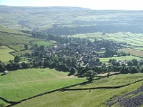
Another notable place is the stone village of Dent
, with very little modern housing. Along Wharfedale
, the route passes through the villages of Grassington
and Kettlewell
.
the route connects with the Windermere Way
.
Other connecting trails may be found on the Dales Way page of the Long Distance Walkers' Association website.
or Buckden
to Dentdale
much too long a day. This is not too difficult to arrange as there are pubs at Hubberholme
and Ribblehead
, and farmhouse/bunkhouse accommodation in Langstrothdale
and (on top of the watershed) at Cam Houses.
Northern England
Northern England, also known as the North of England, the North or the North Country, is a cultural region of England. It is not an official government region, but rather an informal amalgamation of counties. The southern extent of the region is roughly the River Trent, while the North is bordered...
, from (south east to north west) Ilkley
Ilkley
Ilkley is a spa town and civil parish in West Yorkshire, in the north of England. Ilkley civil parish includes the adjacent village of Ben Rhydding and is a ward within the metropolitan borough of Bradford. Approximately north of Bradford, the town lies mainly on the south bank of the River Wharfe...
, West Yorkshire
West Yorkshire
West Yorkshire is a metropolitan county within the Yorkshire and the Humber region of England with a population of 2.2 million. West Yorkshire came into existence as a metropolitan county in 1974 after the passage of the Local Government Act 1972....
to Bowness-on-Windermere
Bowness-on-Windermere
Bowness-on-Windermere is a town in South Lakeland, Cumbria, England. Due its position on the banks of Windermere the town has become a tourist honeypot. Although their mutual growth has caused them to become one large settlement, the town is distinct from the town of Windermere as the two still...
, Cumbria
Cumbria
Cumbria , is a non-metropolitan county in North West England. The county and Cumbria County Council, its local authority, came into existence in 1974 after the passage of the Local Government Act 1972. Cumbria's largest settlement and county town is Carlisle. It consists of six districts, and in...
.
The Dales Way passes through two National Parks: the Yorkshire Dales National Park and the Lake District National Park
Lake District National Park
The Lake District National Park is located in the north-west of England and is the largest of the English National Parks and the second largest in the United Kingdom. It is in the central and most-visited part of the Lake District....
. The first half of the walk follows the River Wharfe
River Wharfe
The River Wharfe is a river in Yorkshire, England. For much of its length it is the county boundary between West Yorkshire and North Yorkshire. The name Wharfe is Celtic and means "twisting, winding".The valley of the River Wharfe is known as Wharfedale...
upstream to the main watershed of northern England at Ribblehead
Ribblehead
Ribblehead is the area of moorland at the head of the River Ribble in the area known as Ribblesdale, in the Yorkshire Dales National Park, England....
. The second half follows several river valleys (Dentdale
Dentdale
The valley of Dentdale in Cumbria and North Yorkshire, England, takes its name from the village of Dent.The Dent Fault cuts across the valley close to the village of Gawthrop, marking a geological boundary between the Carboniferous Limestone of Deepdale and the Craven Dales to the south and the...
, River Mint
River Mint
The River Mint is a river in Cumbria, England. The Mint starts life at Whelpside at the confluence of Bannisdale Beck, running south-east from Bannisdale Head, and a smaller stream draining a group of small valleys from headwaters in The Forest, Combs Hollow and Mabbin Crag.The river runs south to...
, River Kent
River Kent
The River Kent is a short river in the county of Cumbria in England. The river originates in hills surrounding Kentmere, and flows for around 20 miles into the north of Morecambe Bay. The Lake District National Park includes the upper reaches of the river within its boundaries.The river passes...
) to descend to the shores of Windermere.
Background
The walk is shorter and less strenuous than more well-known routes such as the Pennine WayPennine Way
The Pennine Way is a National Trail in England. The trail runs from Edale, in the northern Derbyshire Peak District, north through the Yorkshire Dales and the Northumberland National Park and ends at Kirk Yetholm, just inside the Scottish border. The path runs along the Pennine hills, sometimes...
and Coast to Coast Walk
Coast to Coast Walk
The Coast to Coast Walk is a 192-mile unofficial and mostly unsignposted long distance footpath in Northern England...
, being mostly along river valleys. It thus makes a good introductory training ground for these "serious" walks while being well worth doing in its own right. The section from upper Wharfedale
Wharfedale
Wharfedale is one of the Yorkshire Dales in England. It is the valley of the River Wharfe. Towns and villages in Wharfedale include Buckden, Kettlewell, Conistone, Grassington, Hebden, Ilkley, Burley-in-Wharfedale, Otley, Pool-in-Wharfedale, Arthington, Collingham, and Wetherby...
(Langstrothdale
Langstrothdale
Langstrothdale is a valley in the Yorkshire Dales in North Yorkshire, England. The uppermost course of the River Wharfe runs through it, but Wharfedale does not begin until the Wharfe meets Cray Gill, downstream of Hubberholme....
) over the watershed at Cam Houses and down into Ribblesdale is steep (going up AND down).
It is feasible (for those more interested in a challenge than the enjoyment of the walk) to complete the walk the route in around four days, but most walkers take about a week, dividing the route into sections of 10 to 15 miles per day and taking a "rest day" or two.
Planning an itinerary is generally easy. Public transport (including Windermere
Windermere
Windermere is the largest natural lake of England. It is also a name used in a number of places, including:-Australia:* Lake Windermere , a reservoir, Australian Capital Territory * Lake Windermere...
"steamers") is good at both ends of the route (train stations at Ilkley
Ilkley
Ilkley is a spa town and civil parish in West Yorkshire, in the north of England. Ilkley civil parish includes the adjacent village of Ben Rhydding and is a ward within the metropolitan borough of Bradford. Approximately north of Bradford, the town lies mainly on the south bank of the River Wharfe...
and Windermere
Windermere
Windermere is the largest natural lake of England. It is also a name used in a number of places, including:-Australia:* Lake Windermere , a reservoir, Australian Capital Territory * Lake Windermere...
). The popularity of the walk (and the area generally) means that there are many choices of accommodation - for instance, nearly all pubs along the route do Bed and Breakfast
Bed and breakfast
A bed and breakfast is a small lodging establishment that offers overnight accommodation and breakfast, but usually does not offer other meals. Since the 1980s, the meaning of the term has also extended to include accommodations that are also known as "self-catering" establishments...
.
Notable places
The largest settlements on the route are IlkleyIlkley
Ilkley is a spa town and civil parish in West Yorkshire, in the north of England. Ilkley civil parish includes the adjacent village of Ben Rhydding and is a ward within the metropolitan borough of Bradford. Approximately north of Bradford, the town lies mainly on the south bank of the River Wharfe...
and Bowness-on-Windermere
Bowness-on-Windermere
Bowness-on-Windermere is a town in South Lakeland, Cumbria, England. Due its position on the banks of Windermere the town has become a tourist honeypot. Although their mutual growth has caused them to become one large settlement, the town is distinct from the town of Windermere as the two still...
at either end, and the small town of Sedbergh
Sedbergh
Sedbergh is a small town in Cumbria, England. It lies about east of Kendal and about north of Kirkby Lonsdale. The town sits just within the Yorkshire Dales National Park...
in Dentdale
Dentdale
The valley of Dentdale in Cumbria and North Yorkshire, England, takes its name from the village of Dent.The Dent Fault cuts across the valley close to the village of Gawthrop, marking a geological boundary between the Carboniferous Limestone of Deepdale and the Craven Dales to the south and the...
. The town of Kendal
Kendal
Kendal, anciently known as Kirkby in Kendal or Kirkby Kendal, is a market town and civil parish within the South Lakeland District of Cumbria, England...
(larger than the other places mentioned) is not far from the route.
Another notable place is the stone village of Dent
Dent (Lonsdale)
Dent is a small village and civil parish in Cumbria, England, nestling in a narrow valley on the western slopes of the Pennines within the Yorkshire Dales National Park...
, with very little modern housing. Along Wharfedale
Wharfedale
Wharfedale is one of the Yorkshire Dales in England. It is the valley of the River Wharfe. Towns and villages in Wharfedale include Buckden, Kettlewell, Conistone, Grassington, Hebden, Ilkley, Burley-in-Wharfedale, Otley, Pool-in-Wharfedale, Arthington, Collingham, and Wetherby...
, the route passes through the villages of Grassington
Grassington
Grassington is a market town and civil parish in the Craven district of North Yorkshire, England.The town is situated in Wharfedale around from Bolton Abbey and is surrounded by limestone scenery...
and Kettlewell
Kettlewell
Kettlewell is a village in Upper Wharfedale, North Yorkshire, England. It lies between the villages of Grassington, Kilnsey and Conistone to the south, Starbotton to the north west, the hamlet of Horsehouse to the north east, and later on Coverdale...
.
Connecting trails
Just before it reaches the end at Bowness-on-WindermereBowness-on-Windermere
Bowness-on-Windermere is a town in South Lakeland, Cumbria, England. Due its position on the banks of Windermere the town has become a tourist honeypot. Although their mutual growth has caused them to become one large settlement, the town is distinct from the town of Windermere as the two still...
the route connects with the Windermere Way
Windermere Way
The Windermere Way is a 45 mile circuit of Windermere, a lake in the English Lake District. The route is wholly within the Lake District National Park and takes in the summits of Wansfell, Loughrigg Fell and Gummer's How as well as passing through the towns of Ambleside and Windermere.-History and...
.
Other connecting trails may be found on the Dales Way page of the Long Distance Walkers' Association website.
Warning
Less-experienced walkers should take care when planning the central section (over the watershed). This section has, of course, the greatest ascent and descent, and is rather remote for anyone who finds themselves in difficulties. The less-fit walker needs to arrange accommodation in order to make this section as short as possible. This will almost certainly involve at least one night in a remote farmhouse or pub, because the novice will probably find that the climbing involved will make the walk from KettlewellKettlewell
Kettlewell is a village in Upper Wharfedale, North Yorkshire, England. It lies between the villages of Grassington, Kilnsey and Conistone to the south, Starbotton to the north west, the hamlet of Horsehouse to the north east, and later on Coverdale...
or Buckden
Buckden, North Yorkshire
Buckden is a village and civil parish in the Craven district of North Yorkshire, England.Buckden is situated in the Yorkshire Dales National Park, on the River Wharfe in Wharfedale. According to the 2001 census it had a population of 184. It is situated where Buckden Gill, which rises on Buckden...
to Dentdale
Dentdale
The valley of Dentdale in Cumbria and North Yorkshire, England, takes its name from the village of Dent.The Dent Fault cuts across the valley close to the village of Gawthrop, marking a geological boundary between the Carboniferous Limestone of Deepdale and the Craven Dales to the south and the...
much too long a day. This is not too difficult to arrange as there are pubs at Hubberholme
Hubberholme
Hubberholme is an old village in Upper Wharfedale in the Yorkshire Dales, North Yorkshire, England, at the point where Langstrothdale meets Wharfedale. It is quite secluded and the nearest village is Buckden....
and Ribblehead
Ribblehead
Ribblehead is the area of moorland at the head of the River Ribble in the area known as Ribblesdale, in the Yorkshire Dales National Park, England....
, and farmhouse/bunkhouse accommodation in Langstrothdale
Langstrothdale
Langstrothdale is a valley in the Yorkshire Dales in North Yorkshire, England. The uppermost course of the River Wharfe runs through it, but Wharfedale does not begin until the Wharfe meets Cray Gill, downstream of Hubberholme....
and (on top of the watershed) at Cam Houses.