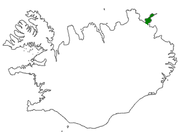
Langanes
Encyclopedia

Peninsula
A peninsula is a piece of land that is bordered by water on three sides but connected to mainland. In many Germanic and Celtic languages and also in Baltic, Slavic and Hungarian, peninsulas are called "half-islands"....
in northeast Iceland
Iceland
Iceland , described as the Republic of Iceland, is a Nordic and European island country in the North Atlantic Ocean, on the Mid-Atlantic Ridge. Iceland also refers to the main island of the country, which contains almost all the population and almost all the land area. The country has a population...
. The name literally means "long peak". It is 40 kilometres (24.9 mi) long from southwest to northeast, ending in a thin strip of land called Fontur. It is bounded by Þistilfjörður
Þistilfjörður
Þistilfjörður is a bay in northeast Iceland, between the Rifstangi and Langanes peninsulas, near the town of Þórshöfn . The name also refers to the region immediately to the southwest of the bay, roughly corresponding to Svalbarðshreppur municipality....
to the northwest and Bakkaflói
Bakkaflói
Bakkaflói is a large bay in eastern Iceland, to the north of Bakkafjordur and to the southeast of Langanes....
to the southeast, while the terrain inland reaches elevations of 200–400 metres (600–1200 feet). The highest point is Gunnólfsvíkurfjall in the southeast of the peninsula.
Administratively, Langanes forms part of the Langanesbyggð
Langanesbyggð
Langanesbyggð is a municipality in northeastern Iceland, just north of Austurland.As of January 2011, it had a total population of 505 and a population density of 0.36 per square kilometre. The total area was 1,333 km²....
municipality
Municipalities of Iceland
The municipalities of Iceland are local administrative areas in Iceland that provide a number of services to their inhabitants such as kindergartens, elementary schools, waste management, social services, public housing, public transportation, services to senior citizens and handicapped people...
(population 480 in 2008). Virtually all of the population live in the village of Þórshöfn
Þórshöfn
Þórshöfn is a small fishing village in northeast Iceland, located on the northern coast of the Langanes peninsula on the Þistilfjörður bay.The village has a population of 380 people. It is the administrative centre of Langanesbyggð municipality and of the neighbouring Svalbarðshreppur municipality...
(Thorshofn) on the northwestern coast, which has a small airport. Sauðanes, just to the north of Þórshöfn, has an ancient church which has been converted into a museum. The fishing village of Skálar, on the southeastern coast near the tip of the peninsula, had a population of over a hundred in the early 20th century, but was abandoned by 1946. Other abandoned settlements include Heiðarhöfn, Læknistaðir, Skoruvík, Fagranes and Saurbær. A NATO radar
Radar
Radar is an object-detection system which uses radio waves to determine the range, altitude, direction, or speed of objects. It can be used to detect aircraft, ships, spacecraft, guided missiles, motor vehicles, weather formations, and terrain. The radar dish or antenna transmits pulses of radio...
station was operated on Heiðarfjall from 1954 to 1968.
In the spring time (May–June) seabirds (guillemot
Guillemot
Guillemots is the common name for several species of seabird in the auk family . In British use, the term comprises two genera: Uria and Cepphus. In North America the Uria species are called "murres" and only the Cepphus species are called "guillemots"...
and kittiwake
Kittiwake
The kittiwakes are two closely related seabird species in the gull family Laridae, the Black-legged Kittiwake and the Red-legged Kittiwake . The epithets "Black-legged" and "Red-legged" are used to distinguish the two species in North America, but in Europe, where R...
) lay their eggs in the cliffs at Langanes and for those interested there may be an opportunity to watch egg-gatherers at work in the cliffs. The Langanes peninsula is popular with bird-watchers and holds the third largest gannet
Gannet
Gannets are seabirds comprising the genus Morus, in the family Sulidae, closely related to the boobies.The gannets are large black and white birds with yellow heads. They have long pointed wings and long bills. Northern gannets are the largest seabirds in the North Atlantic, with a wingspan of up...
nesting place in the world at Stórkarl.

