

Land's End to John o' Groats
Encyclopedia
Great Britain
Great Britain or Britain is an island situated to the northwest of Continental Europe. It is the ninth largest island in the world, and the largest European island, as well as the largest of the British Isles...
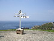
between two extremities; in the southwest and northeast. The traditional distance by road is 874 miles (1,406.6 km) and takes most cyclists ten to fourteen days; the record for running the route is nine days. Off-road walkers typically walk 1200 miles (1,931.2 km) and take two or three months for the expedition. Two much-photographed signposts indicate the traditional distance at each end.
- Land's EndLand's EndLand's End is a headland and small settlement in west Cornwall, England, within the United Kingdom. It is located on the Penwith peninsula approximately eight miles west-southwest of Penzance....
is the extreme southwestward (but not southern or western) point of Great Britain, situated in western CornwallCornwallCornwall is a unitary authority and ceremonial county of England, within the United Kingdom. It is bordered to the north and west by the Celtic Sea, to the south by the English Channel, and to the east by the county of Devon, over the River Tamar. Cornwall has a population of , and covers an area of...
at the end of the Penwith peninsulaPenwithPenwith was a local government district in Cornwall, England, United Kingdom, whose council was based in Penzance. The district covered all of the Penwith peninsula, the toe-like promontory of land at the western end of Cornwall and which included an area of land to the east that fell outside the...
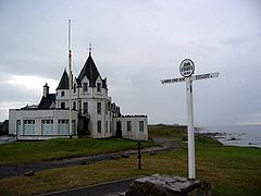
, O.S. Grid Reference SW342250, Post Code TR19 7AA. - John o' GroatsJohn o' GroatsJohn o' Groats is a village in the Highland council area of Scotland. Part of the county of Caithness, John o' Groats is popular with tourists because it is usually regarded as the most northerly settlement of mainland Great Britain, although this is not a claim made by the inhabitants...
is the traditionally acknowledged extreme northern point of mainland Scotland, in northeastern CaithnessCaithnessCaithness is a registration county, lieutenancy area and historic local government area of Scotland. The name was used also for the earldom of Caithness and the Caithness constituency of the Parliament of the United Kingdom . Boundaries are not identical in all contexts, but the Caithness area is...
, O.S. Grid Reference ND380735, Post Code KW1 4YR. The actual northernmost point is at nearby Dunnet HeadDunnet HeadDunnet Head is a peninsula in Caithness, on the north coast of Scotland, that includes the most northerly point of the mainland of Great Britain. The point, known as Easter Head, is at , about westnorthwest of John o' Groats and about from Duncansby Head...
. The point that is actually farthest by road from Land's End is Duncansby HeadDuncansby HeadDuncansby Head is the most north-easterly part of the Scottish mainland, including even the famous John o' Groats, Caithness, Highland...
, about 2 miles (3.2 km) from John o' Groats.
The straight-line distance from Land's End to John o' Groats is 603 miles (970.4 km) as determined from O.S. Grid References, but such a route passes over a series of stretches of water in the Irish Sea
Irish Sea
The Irish Sea separates the islands of Ireland and Great Britain. It is connected to the Celtic Sea in the south by St George's Channel, and to the Atlantic Ocean in the north by the North Channel. Anglesey is the largest island within the Irish Sea, followed by the Isle of Man...
.
According to a road atlas of 1964, the shortest route using classified roads was 847 miles (1,363.1 km).
According to a road atlas of 2008, the shortest route using classified roads was 838 miles (1,348.6 km).
According to an on-line route planner of 2011, the quickest route by road was 838 miles (1,348.6 km) and took 15 hours 48 minutes (this uses A30, M5, M6, A74(M), M74, M73, M80, M9, A9 & A99).
However, with the advent of modern bridges, the shortest route by road has been reduced to around 814 miles (1,310 km). This route, using minor roads in numerous places, roughly follows: Land's End, Okehampton, Tiverton, Bridgwater, M5 Avon Bridge, M48 Severn Bridge, Monmouth, Hereford, Shrewsbury, Tarporley, St Helens, Preston, Carlisle, Beattock, Carstairs, Whitburn, Falkirk, Stirling, Crieff, Kenmore, Dalchalloch, A9, Inverness, A9 (Kessock Bridge, Cromarty Bridge, Dornoch Firth Bridge), Latheron, Wick, John o'Groats.
Methods
Expeditions from Land's End to John o' Groats have been undertaken using numerous forms of transport, and are often organised as charity fundraisers, sometimes involving celebrities: examples include cricketer Ian BothamIan Botham
Sir Ian Terence Botham OBE is a former England Test cricketer and Test team captain, and current cricket commentator. He was a genuine all-rounder with 14 centuries and 383 wickets in Test cricket, and remains well-known by his nickname "Beefy"...
's 1985 walk and athlete Jane Tomlinson
Jane Tomlinson
Jane Emily Tomlinson, CBE was an amateur English athlete who became well known in the United Kingdom for raising £1.85 million for charity by completing a series of athletic challenges, despite suffering from terminal cancer.Having had treatment for breast cancer in 1991, aged 26; the disease...
's 2003 cycle ride.
Walking
The first recorded end-to-end walk (actually from John o' Groats to Land's End) was undertaken by the brothers John and Robert Naylor in 1871. Since then the walk has been undertaken many times, more particularly since 1960, after a well-publicised road walk by Dr Barbara MooreBarbara Moore (vegetarian)
Dr. Barbara Moore was a Russian-born health enthusiast who gained celebrity in the early 1960s for her long-distance walking....
. In 1960 the entrepreneur Billy Butlin
Billy Butlin
Sir William Heygate Edmund Colborne Butlin, , was a British, South Africa-born entrepreneur whose name is synonymous with the British holiday camp.American Heritage Dictionary 2004, p. 135.Scott 2001, p. 5...
organised a road walking race, which gave further impetus to the idea.
Since the 1960s, walkers have mostly chosen off-road routes, using the growing network of long-distance footpaths
Long-distance footpaths in the United Kingdom
-England and Wales: National Trails:National Trails are distinguished by being maintained by the National Trails organization . , there are fifteen such trails, one of which is not yet complete....
. A classic account is from 1966 by the travel writer John Hillaby
John Hillaby
John Hillaby was a British travel writer and explorer.Hillaby was the son of a Yorkshire printer. He was educated at Woodhouse Grove School, Leeds. He embarked on a career in journalism, interrupted by service in the Second World War...
. Off-road walkers usually complete the journey in two to three months. There is a considerable choice of off-road routes, but all are much longer than the shortest road distance, usually 1200 miles (1,931.2 km) or more. The walk is still undertaken by road walkers, often doing the walk, like Sir Ian Botham, for charity, or as a "challenge walk". They typically take a month or even less.
Routes
There is no continuous long-distance path from Land's End to John o' Groats. There are long-distance paths for substantial sections of the route, and where they do not exist walkers connect them by rights of way and minor roads. Most walkers broadly follow these routes:- from Land's End to ExmoorExmoorExmoor is an area of hilly open moorland in west Somerset and north Devon in South West England, named after the main river that flows out of the district, the River Exe. The moor has given its name to a National Park, which includes the Brendon Hills, the East Lyn Valley, the Vale of Porlock and ...
by the South West Coast PathSouth West Coast PathThe South West Coast Path is Britain's longest waymarked long-distance footpath and a National Trail. It stretches for , running from Minehead in Somerset, along the coasts of Devon and Cornwall, to Poole Harbour in Dorset. Since it rises and falls with every river mouth, it is also one of the more...
; or by a shorter inland route through CornwallCornwallCornwall is a unitary authority and ceremonial county of England, within the United Kingdom. It is bordered to the north and west by the Celtic Sea, to the south by the English Channel, and to the east by the county of Devon, over the River Tamar. Cornwall has a population of , and covers an area of...
and DevonDevonDevon is a large county in southwestern England. The county is sometimes referred to as Devonshire, although the term is rarely used inside the county itself as the county has never been officially "shired", it often indicates a traditional or historical context.The county shares borders with...
by minor roads and paths, the Two Castles TrailTwo Castles TrailThe Two Castles Trail is a waymarked long distance footpath in Devon and Cornwall, England. It runs for from Okehampton in Devon to Launceston in Cornwall, linking the two Norman castles of Okehampton and Launceston....
and the towpath of the Grand Western CanalGrand Western CanalThe Grand Western Canal ran between Taunton in Somerset and Tiverton in Devon in the United Kingdom. The canal had its origins in various plans, going back to 1796, to link the Bristol Channel and the English Channel by a canal, bypassing Lands End... - across SomersetSomersetThe ceremonial and non-metropolitan county of Somerset in South West England borders Bristol and Gloucestershire to the north, Wiltshire to the east, Dorset to the south-east, and Devon to the south-west. It is partly bounded to the north and west by the Bristol Channel and the estuary of the...
by parts of the Macmillan Way WestMacmillan Way WestThe Macmillan Way West is a long distance footpath in Somerset and Devon, England. It runs for from Castle Cary in Somerset to Barnstaple in Devon. It is one of the Macmillan Ways and connects with the main Macmillan Way at Castle Cary....
, the Samaritans Way South West or the Limestone LinkLimestone LinkThe Limestone Link is a long-distance footpath from the Mendip Hills in Somerset to Cold Ashton in Gloucestershire. It is marked by an Ammonite waymarker.... - to the Peak DistrictPeak DistrictThe Peak District is an upland area in central and northern England, lying mainly in northern Derbyshire, but also covering parts of Cheshire, Greater Manchester, Staffordshire, and South and West Yorkshire....
either by- an eastern route using the Cotswold WayCotswold WayThe Cotswold Way is a long-distance footpath, running along the Cotswold Edge escarpment of the Cotswold Hills in England. It was officially inaugurated as a National Trail on 24 May 2007 and several new rights of way have been created.-History:...
, the Heart of England WayHeart of England WayThe Heart of England Way is a long distance walk of around through the Midlands of England. The walk starts from Milford Common on Cannock Chase and ends at Bourton on the Water in the Cotswolds passing through the counties of Staffordshire, Warwickshire and Gloucestershire.The walk provides links...
(or the Severn WaySevern WayThe Severn Way is a waymarked long-distance footpath in the United Kingdom following the course of the River Severn in the West Country of England and Mid Wales.-Distance:...
), the Staffordshire WayStaffordshire WayThe Staffordshire Way is a long distance walk in Staffordshire, England. The path links with the Cheshire Gritstone Trail, the Heart of England Way and the North Worcestershire Path.- The route :...
and the Limestone WayLimestone WayThe Limestone Way is a long-distance bridleway in Derbyshire, England. It runs through the White Peak of the Peak District National Park, from Castleton south east to Rocester over the county boundary in Staffordshire. It originally ran to Matlock, but was diverted to its current, longer route to...
; or - a western route across the Severn BridgeSevern BridgeThe Severn Bridge is a suspension bridge spanning the River Severn between South Gloucestershire, just north of Bristol, England, and Monmouthshire in South Wales, via Beachley, a peninsula between the River Severn and River Wye estuary. It is the original Severn road crossing between England and...
then by the Offa's Dyke PathOffa's Dyke PathOffa's Dyke Path is a long distance footpath along the Welsh-English border. Opened in 1971, it is one of Britain's premier National Trails and draws walkers from throughout the world...
, the Maelor WayMaelor WayMaelor Way is a key long distance footpath, running 38 kilometres / 24 miles from the Offa's Dyke Path National Trail at Bronygarth to the Shropshire Way, Sandstone Trail, Llangollen Canal, South Cheshire Way, and the Marches Way all at Grindley Brook near Whitchurch.- The route :Most of the way is...
and the South Cheshire WaySouth Cheshire WayThe South Cheshire Way is a long-distance footpath running east–west mainly through Cheshire, England, though parts lie in Shropshire and Staffordshire. The western section from Grindley Brook, near Whitchurch, runs through farmland; the eastern section from Mow Cop, near Biddulph, runs through...
- an eastern route using the Cotswold Way
- to the Scottish BordersScottish BordersThe Scottish Borders is one of 32 local government council areas of Scotland. It is bordered by Dumfries and Galloway in the west, South Lanarkshire and West Lothian in the north west, City of Edinburgh, East Lothian, Midlothian to the north; and the non-metropolitan counties of Northumberland...
by the Pennine WayPennine WayThe Pennine Way is a National Trail in England. The trail runs from Edale, in the northern Derbyshire Peak District, north through the Yorkshire Dales and the Northumberland National Park and ends at Kirk Yetholm, just inside the Scottish border. The path runs along the Pennine hills, sometimes... - by St. Cuthbert's WaySt. Cuthbert's WaySt Cuthbert's Way is a long-distance trail between the Scottish Borders town of Melrose and Lindisfarne off the coast of Northumberland, England.It is part of the European walking route E2....
and a section of the Southern Upland WaySouthern Upland WayOpened in 1984, the Southern Upland Way is a coast to coast walk in Scotland between Portpatrick in the west and Cockburnspath in the east....
to the Pentland HillsPentland HillsThe Pentland Hills are a range of hills to the south-west of Edinburgh, Scotland. The range is around 20 miles in length, and runs south west from Edinburgh towards Biggar and the upper Clydesdale.Some of the peaks include:* Scald Law...
, then by- a western route using the towpaths of the Union CanalUnion Canal (Scotland)The Union Canal is a 31.5-mile canal in Scotland, from Lochrin Basin, Fountainbridge, Edinburgh to Falkirk, where it meets the Forth and Clyde Canal.-Location and features:...
and the Forth and Clyde CanalForth and Clyde CanalThe Forth and Clyde Canal crosses Scotland, providing a route for sea-going vessels between the Firth of Forth and the Firth of Clyde at the narrowest part of the Scottish Lowlands. The canal is 35 miles long and its eastern end is connected to the River Forth by a short stretch of the River...
, then by the West Highland WayWest Highland WayThe West Highland Way is a linear long distance footpath in Scotland, with the official status of Long Distance Route. It is 154.5km long, running from Milngavie north of Glasgow to Fort William in the Scottish Highlands, with an element of hill walking in the route...
and the Great Glen WayGreat Glen WayThe Great Glen Way is a long distance footpath in Scotland. It follows the Great Glen, running from Fort William in the west to Inverness in the east, covering 73 miles . It was opened in 2002 and is one of Scotland's four long distance routes. The Great Glen Way is generally walked from west to...
to InvernessInvernessInverness is a city in the Scottish Highlands. It is the administrative centre for the Highland council area, and is regarded as the capital of the Highlands of Scotland...
; or - an eastern route across the Forth Road BridgeForth Road BridgeThe Forth Road Bridge is a suspension bridge in east central Scotland. The bridge, opened in 1964, spans the Firth of Forth, connecting the capital city Edinburgh, at South Queensferry, to Fife, at North Queensferry...
to PerthPerth, ScotlandPerth is a town and former city and royal burgh in central Scotland. Located on the banks of the River Tay, it is the administrative centre of Perth and Kinross council area and the historic county town of Perthshire...
and PitlochryPitlochryPitlochry , is a burgh in the council area of Perth and Kinross, Scotland, lying on the River Tummel. Its population according to the 2001 census was 2,564....
, then by Glen TiltGlen TiltGlen Tilt is a glen in the extreme north of Perthshire, Scotland. Beginning at the confines of Aberdeenshire, it follows a South-westerly direction excepting for the last 4 miles, when it runs due south to Blair Atholl...
and the Lairig GhruLairig GhruThe Lairig Ghru is one of the mountain passes through the Cairngorms of Scotland.Like many traditional routes the ends of the route through the Lairig Ghru are like the ends of a frayed rope. From the south the Lairig Ghru can be approached from Braemar though Glen Lui, or Glen Dee, and from Blair...
to SpeysideStrathspey, ScotlandStrathspey is the area around the strath of the River Spey, Scotland, in both the Moray council area and the Badenoch and Strathspey committee area of Highland....
and the old Wade road to Inverness.
- a western route using the towpaths of the Union Canal
- from Inverness to John o' Groats, there is no long distance footpath, so the route is mostly on roads with a few stretches of coast walking; to avoid road walking, some walkers head north west from the end of the West Highland Way at Fort WilliamFort William, ScotlandFort William is the second largest settlement in the highlands of Scotland and the largest town: only the city of Inverness is larger.Fort William is a major tourist centre with Glen Coe just to the south, Aonach Mòr to the north and Glenfinnan to the west, on the Road to the Isles...
using parts of the Cape Wrath TrailCape Wrath TrailCape Wrath Trail is a hiking route that runs through the Scottish Highlands and along the west coast of Scotland.It is approximately 200 miles in length and is considered to be one of the most challenging long distance walks in the UK...
, then head northeast through the Flow CountryFlow CountryThe Flow Country is a large, rolling expanse of peatland and wetland area of Caithness and Sutherland in Scotland. It is the largest expanse of blanket bog in Europe, and covers about 4,000 square kilometres ....
of CaithnessCaithnessCaithness is a registration county, lieutenancy area and historic local government area of Scotland. The name was used also for the earldom of Caithness and the Caithness constituency of the Parliament of the United Kingdom . Boundaries are not identical in all contexts, but the Caithness area is...
. However, this route is through remote country and requires wild camping.
Cycling
The official Road Records AssociationRoad Records Association
The Road Records Association is a British cycle racing organisation which supervises records on the road but not in conventional races. It is one of the oldest cycle sport organisations in the world, formed in 1888.-Remit:...
record for rider on a conventional bicycle is 44 hours, 4 minutes and 20 seconds, set by Gethin Butler in 2001. The record for cycling from Land's End to John o' Groats is held by Andy Wilkinson, who completed the journey in 41 hours, 4 minutes and 22 seconds on a Windcheetah recumbent tricycle
Tricycle
A tricycle is a three-wheeled vehicle. While tricycles are often associated with the small three-wheeled vehicles used by pre-school-age children, they are also used by adults for a variety of purposes. In the United States and Canada, adult-sized tricycles are used primarily by older persons for...
. A more typical cycling time is ten to fourteen days. Ben Rockett, a postgraduate student from the University of Bath
University of Bath
The University of Bath is a campus university located in Bath, United Kingdom. It received its Royal Charter in 1966....
became on 27 August 2010 the record holder for cycling from Land's End to John O’Groats and back again in 5 days, 21 hours and 8 minutes. From 1 to 4 March 2010, David Walliams
David Walliams
David Edward Walliams is an English comedian, writer and actor, known for his partnership with Matt Lucas on the TV sketch show Little Britain and its predecessor Rock Profile...
, Jimmy Carr
Jimmy Carr
James Anthony Patrick "Jimmy" Carr is an English-Irish comedian and humourist. He is known for his deadpan delivery and dark humour. He is also a writer, actor and presenter of radio and television....
, Fearne Cotton
Fearne Cotton
Fearne Cotton is an English television and radio presenter who is known for presenting a number of popular TV programmes such as Top of the Pops and the Red Nose Day telethon. In 2007, she became the first regular female presenter of BBC Radio 1's Chart Show...
, Miranda Hart
Miranda Hart
Miranda Katharine Hart Dyke , known professionally as Miranda Hart, is an English actress, writer and stand-up comedienne. She writes and stars in the BBC sitcom Miranda...
, Patrick Kielty
Patrick Kielty
Patrick Kielty is an Irish comedian and television personality from Dundrum, Northern Ireland.-Background:He was affected by The Troubles in Northern Ireland. On 25 January 1988 his father, businessman Jack Kielty, was shot dead by the Ulster Defence Association /"Ulster Freedom Fighters" , a...
, Davina McCall
Davina McCall
Davina McCall is an English television presenter and actress, most notable as the presenter of the UK version of Big Brother up until its move to Channel 5.- Early life :...
and Russell Howard
Russell Howard
Russell Joseph Howard is an English comedian best known for his TV show Russell Howard's Good News and his appearances on the topical panel TV show Mock The Week...
cycled in a team relay from John o' Groats to Land's End to raise money for Sport Relief
Sport Relief
Sport Relief is a biennial charity event from Comic Relief, in association with BBC Sport, which brings together the worlds of sport and entertainment to raise money to help vulnerable people in both the UK and the world's poorest countries...
.
There have been several unicycle
Unicycle
A unicycle is a human-powered, single-track vehicle with one wheel. Unicycles resemble bicycles, but are less complex.-History:One theory of the advent of the unicycle stems from the popularity of the penny-farthing during the late 19th century...
completions of the journey. The Guinness World Record for the fastest completion by unicycle is held by Roger Davies and Sam Wakeling, who rode 862 miles (1,387.3 km) (Land’s End to John O’Groats) from 12 September to 18 September 2009 in 6 days, 8 hours and 43 minutes. They rode large 36" wheeled unicycles equipped with two-speed Schlumpf geared hubs.
The one-way distance is similar to that of 875 miles (1,408.2 km) London–Edinburgh–London, the longest regular scheduled Audax
Audax (cycling)
Audax is a cycling sport in which participants attempt to cycle long distances within a pre-defined time limit. Audax is a non-competitive sport: success in an event is measured by its completion. Audax has its origins in Italian endurance sports of the late nineteenth century, and the rules were...
cycle ride.
Wheelchair
The fastest time in a wheelchair was achieved in August 2009 by US Navy Pilot Rick Ryan: 8 days, 10 hours and 9 minutes.Running
The record time for a runner to complete the route, as reported by the Land's End John o' Groats Club, is nine days and two hours, by Andi Rivett. In July 2008, Dan Driver became the first to run the route solo, meaning he carried all his equipment with him whilst he ran it. He completed the run in just over seventeen days.On 12 July 2009 British ultramarathon
Ultramarathon
An ultramarathon is any sporting event involving running longer than the traditional marathon length of .There are two types of ultramarathon events: those that cover a specified distance, and events that take place during specified time...
runner Kevin Carr successfully completed the first ever attempt to run the route off-road, becoming the first athlete to run the length of the UK as a Fell/Trail run. Like Driver, Carr ran unsupported and solo—a format commonly known amongst fell runners as a "Mountain Marathon". Carr ran the challenge as part of an event organised by Benumber1, an event that saw several top-level British athletes (mainly Olympians) completing the challenge. The event was designed to encourage school students to participate in sport and to realise the positive benefits of a healthy lifestyle, whilst raising significant funds for the British Heart Foundation
British Heart Foundation
The British Heart Foundation is a charity organisation in Britain that funds research, education, care and awareness campaigns aimed to prevent heart diseases in humans.-Foundation:...
. The run covered 1,254 miles over footpaths, bridleways, canal paths, river banks, National trails, fields, moorland and mountains. Over 80% of the route was off-road, the route resorting to tarmac only when necessary to link two trails, or where a trail passed through a village/town. The run took 6 weeks 3 days and 17 hours to complete (including three rest days). Factoring in the rest days, this run called for an average effort of just under 30 miles a day, every day, for more than six weeks.
Skateboard
The record time to complete the 980 miles (1,577.2 km) journey on a skateboard is 21 days, achieved by Matt Elver, Charlie Mason and Lee Renshaw, who travelled around fifty miles per day in order to raise money for charity.Motoring
Motoring events between the two extremities have been held since the first decade of the 20th century, when the Auto-Cycle Union organised a series of runs for motorcycles. In 1911, Ivan B. Hart-Davies became the holder of the final Land's End to John o' Groats record for solo motorcycles. Riding his 3.5hp single-speed Triumph, he covered the 886 miles in 29 hours, 12 minutes. As his average speed exceeded the then-maximum of 20mph, further official record attempts were banned by the A. C. U.The Motor Cycling Club
Motor Cycling Club
The Motor Cycling Club is a British motorsports and Motorcycle sport club formed in 1901. It is a member of both the Motor Sports Association and Auto-Cycle Union...
(which had been running the London to Land's End Trial since 1908, still held today, at least in name) put on an annual Land's End to John o' Groats Run from 1923 to 1928 which included cars as well as motorcycles. These events were also known as the End to End. In 2006, BBC Television
BBC Television
BBC Television is a service of the British Broadcasting Corporation. The corporation, which has operated in the United Kingdom under the terms of a Royal Charter since 1927, has produced television programmes from its own studios since 1932, although the start of its regular service of television...
ran a series of three programmes called The Lost World of Friese-Greene
The Lost World of Friese-Greene
The Lost World of Friese-Greene is a BBC documentary series produced in conjunction with the British Film Institute. Three one-hour episodes were broadcast on BBC Two in spring 2006....
covering Claude Friese-Greene
Claude Friese-Greene
Claude Friese-Greene , British-born cinema technician, filmmaker, and cinematographer, most famous for his 1926 collection of films entitled The Open Road....
's 1920s-era road trip from Land's End to John o' Groats. The trip had originally been filmed using the Biocolour process, developed by Claude's father William Friese-Greene
William Friese-Greene
William Friese-Greene was a British portrait photographer and prolific inventor. He is principally known as a pioneer in the field of motion pictures and is credited by some as the inventor of cinematography.-Career:William Edward Green was born on 7 September 1855, in Bristol...
and the film had degraded. The original print of Claude's film was subjected to computer enhancement by the British Film Institute
British Film Institute
The British Film Institute is a charitable organisation established by Royal Charter to:-Cinemas:The BFI runs the BFI Southbank and IMAX theatre, both located on the south bank of the River Thames in London...
to remove the flickering problem inherent in the Biocolour process.
In 1984, Neal Champion covered 884 miles from John O'Groats to Land's End in 11 hours, 14 minutes, on a Kawasaki
Kawasaki
-Places:*Kawasaki, Kanagawa, Japanese city**Kawasaki-ku, Kawasaki, a ward in Kawasaki, Kanagawa***Kawasaki Stadium, a multi-sport stadium***Kawasaki Station, a train station***Keikyū Kawasaki Station, a train station*Kawasaki, Fukuoka, Japanese town...
GPZ750 Turbo.
In 1993, John Brown initiated the Land's End to John o' Groats Historic Reliability Trial, a race for vintage road vehicles. The race is held each December and is a tough, three-day rally for old and classic cars, built between the 1920s and 1970s. The route takes a long 1400 miles (2,253.1 km) route, using remote upland roads of the west of England, Wales (during the night), the Pennines and Scotland. Medals are awarded in gold, silver and bronze categories.
On 15–16 April 1997, Hugh Edeleanu drove the route in a JCB
J. C. Bamford
JCB is a global construction, demolition and agricultural equipment company headquartered in Rocester, United Kingdom. It is the world's third-largest construction equipment manufacturer. It produces over 300 types of machines, including diggers , excavators, tractors and diesel engines...
excavator in a time of 22 hours, 10 minutes and 30 seconds.
On 22 May 2011, Kevin Sharpe and David Peilow completed the first end-to-end run from John O'Groats to Land's End in an electric car over two days, using only charging points available to the general public, in a Tesla Roadster
Tesla Roadster
The Tesla Roadster is a battery electric vehicle sports car produced by the electric car firm Tesla Motors in California. The Roadster was the first highway-capable all-electric vehicle in serial production available in the United States. Since 2008 Tesla has sold 2,024 Roadsters in 30 countries...
Sport.
Public transport
Free travel pass
A free travel pass is the privilege of a certain class of passengers to use a public transport service without paying a fare or presenting a ticket...
for people over 60, allowing free off-peak travel on local bus services throughout England) introduced on 1 April 2008, and the pre-existing equivalent concession for pensioners in Scotland. He completed the first leg of the trip in one week and six hours. The entire journey was completed in two weeks, eight hours and thirty minutes.
In 1954, Gertrude Leather travelled by seventeen local buses from Land's End to London, at a cost of £1 19s 6d (£1.97½), and the following year travelled from London to John o' Groats by 25 local buses at a cost of £4 5s 9½d (£4.29).
The current fastest route on land public transport takes a timetabled 22 hours 45 minutes, departing Land's End car park at 14:35 on day 1 and arriving at John o' Groats ferry terminal car park at 13:20 on day 2. This involves a bus to Penzance, trains to Crewe to meet the London–Inverness sleeper train, then the following morning buses via Wick to John o' Groats. , an ordinary one-way railway fare for the rail section of the journey cost £216.
Hitchhiking
M. Clark and G. Beynon are the last hitchhikers recorded in the Guinness Book of Records for the Land's End to John O'Groats trip (17 hours 8 minutes).Youngest and oldest
The Land's End–John o' Groats Association presents the Jack Adams/Richard Elloway Trophy annually to the youngest person to have completed the journey other than as a passenger in a motor vehicle. Henry Cole completed the journey in June 2006, he was aged 4. He cycled over 31 days. He started school in the following September, and was presented with the Jack Adams/Richard Elloway Trophy in January 2007.Reg Savill is oldest person to complete the journey on foot (although in the reverse direction from John O'Groats to Land's End), at the age of 74.
Organisations
There are two organisations supporting people undertaking the journey.- The Land's End–John o' Groats Association is a non-commercial organisation established in 1983 for "those who have completed the epic journey from Land’s End to John o' Groats, or vice versa, by any means in a single trip".
- The Land's End John o' Groats Club, which is sponsored by the company that operates facilities at Land's End and John o' Groats, the end points. It holds an Annual Awards ceremony to select the most notable 'end-to-enders' each year.
Scottish equivalent
Until Union with EnglandActs of Union 1707
The Acts of Union were two Parliamentary Acts - the Union with Scotland Act passed in 1706 by the Parliament of England, and the Union with England Act passed in 1707 by the Parliament of Scotland - which put into effect the terms of the Treaty of Union that had been agreed on 22 July 1706,...
in 1707, Scotland
Scotland
Scotland is a country that is part of the United Kingdom. Occupying the northern third of the island of Great Britain, it shares a border with England to the south and is bounded by the North Sea to the east, the Atlantic Ocean to the north and west, and the North Channel and Irish Sea to the...
's equivalent of the phrase was often "John o' Groats to Maidenkirk", as Maidenkirk
Maidenkirk
Maidenkirk is a small settlement in Galloway, ScotlandUntil Union with England, Scotland's equivalent of the phrase "Land's End to John o' Groats" was often "John o' Groats to Maidenkirk", as Maidenkirk was traditionally considered the southernmost part of that country...
was traditionally considered Scotland's southernmost point, a 388 mile trip. This can be found in Robert Burns
Robert Burns
Robert Burns was a Scottish poet and a lyricist. He is widely regarded as the national poet of Scotland, and is celebrated worldwide...
' poem On Captain Grose
Francis Grose
Francis Grose was an English antiquary, draughtsman, and lexicographer. He was born at his father's house in Broad Street, St-Peter-le-Poer, London, son of a Swiss immigrant and jeweller, Francis Jacob Grose , and his wife, Anne , daughter of Thomas Bennett of Greenford in Middlesex...
's Peregrinations thro' Scotland and the song, The Lady of Kenmure:
- From John o' Groats to Maidenkirk
- You'll never find a truer
- For loyal faith and dauntless deeds,
- Than the Lady of Kenmure.
Further reading
Road walking- Smailes, B. (2004) John o' Groats to Land's End: the Official Challenge Guide Challenge Publications ISBN 1903568187
Offroad walking
- Robinson, A. (2007) The End to End Trail: Land's End to John o' Groats on Foot Cicerone ISBN 9781852845124
- McCloy, A. (2001) The Land's End to John o' Groats Walk Cordee ISBN 1871890594
- Salter, M. (2006) Land's End to John o' Groats - a Thousand Mile Walking Route Folly Publications ISBN 9781871731712
Cycling
- Smailes Brian (2009) Land's End to John o' Groats Cycle Guide - The Official Challenge Guide Challenge Publications ISBN 978-1-903568-59-0
- Brown, Simon (1995) Land's End to John o' Groats Cycle Guide, Cicerone ISBN 9781852841881
- Salter, P. (2002) Bike Britain: Cycling from Land's End to John o' Groats Epic New Zealand ISBN 0958225618