
Cape Wrath Trail
Encyclopedia
Cape Wrath Trail is a hiking
route that runs through the Scottish Highlands
and along the west coast of Scotland
.
It is approximately 200 miles in length and is considered to be one of the most challenging long distance
walks in the UK. Despite not being an officially recognised National Trail it has grown to be one the most highly regarded backpacking routes, attracting hikers from around the world.
The trek initially gained prominence via a 1996 book by David Paterson entitled The Cape Wrath Trail: A New 200-mile Walking Route Through the North-west Scottish Highlands. This was followed in 1999 by a separate publication (North to the Cape: A trek from Fort William to Cape Wrath) by Denis Brook and Phil Hinchliffe.
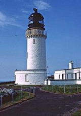
In both versions the trail begins in Fort William and ends at Cape Wrath lighthouse on the northwest tip of the Scottish mainland. It connects with the West Highland Way
and part of an alternative route suggested by Cameron McNeish
follows the Great Glen Way
out of Fort William before joining the main route in Glen Shiel.
A new, updated guidebook to the Cape Wrath Trail is currently being written and is due to be published by Cicerone
in 2012.
These guidebooks estimate an experienced hiker should be able to traverse the entire route in less than 20 days. However the two sets of authors detail slightly different routes and stages for hikers to follow.
Officially the trail is not endorsed by Scottish Natural Heritage
and it is not waymarked or signposted. Facilities along the trail are also minimal and it covers some of the remotest parts of mainland Britain
.
Hiking
Hiking is an outdoor activity which consists of walking in natural environments, often in mountainous or other scenic terrain. People often hike on hiking trails. It is such a popular activity that there are numerous hiking organizations worldwide. The health benefits of different types of hiking...
route that runs through the Scottish Highlands
Scottish Highlands
The Highlands is an historic region of Scotland. The area is sometimes referred to as the "Scottish Highlands". It was culturally distinguishable from the Lowlands from the later Middle Ages into the modern period, when Lowland Scots replaced Scottish Gaelic throughout most of the Lowlands...
and along the west coast of Scotland
Scotland
Scotland is a country that is part of the United Kingdom. Occupying the northern third of the island of Great Britain, it shares a border with England to the south and is bounded by the North Sea to the east, the Atlantic Ocean to the north and west, and the North Channel and Irish Sea to the...
.
It is approximately 200 miles in length and is considered to be one of the most challenging long distance
Long Distance Routes
Long Distance Route is an official term for maintained long-distance footpaths in Scotland that require several days to walk...
walks in the UK. Despite not being an officially recognised National Trail it has grown to be one the most highly regarded backpacking routes, attracting hikers from around the world.
The trek initially gained prominence via a 1996 book by David Paterson entitled The Cape Wrath Trail: A New 200-mile Walking Route Through the North-west Scottish Highlands. This was followed in 1999 by a separate publication (North to the Cape: A trek from Fort William to Cape Wrath) by Denis Brook and Phil Hinchliffe.
In both versions the trail begins in Fort William and ends at Cape Wrath lighthouse on the northwest tip of the Scottish mainland. It connects with the West Highland Way
West Highland Way
The West Highland Way is a linear long distance footpath in Scotland, with the official status of Long Distance Route. It is 154.5km long, running from Milngavie north of Glasgow to Fort William in the Scottish Highlands, with an element of hill walking in the route...
and part of an alternative route suggested by Cameron McNeish
Cameron McNeish
Cameron McNeish is a wilderness hiker, backpacker and mountain walker who is an authority on outdoor pursuits. In this field he is best known as an author and broadcaster although he is also a magazine editor, lecturer and after dinner speaker as well as being an adviser to various outdoor...
follows the Great Glen Way
Great Glen Way
The Great Glen Way is a long distance footpath in Scotland. It follows the Great Glen, running from Fort William in the west to Inverness in the east, covering 73 miles . It was opened in 2002 and is one of Scotland's four long distance routes. The Great Glen Way is generally walked from west to...
out of Fort William before joining the main route in Glen Shiel.
A new, updated guidebook to the Cape Wrath Trail is currently being written and is due to be published by Cicerone
Cicerone (publisher)
Cicerone is an English publisher specialising in guidebooks for walkers, climbers, and cyclists in Europe. It was founded in 1967 and is based in Milnthorpe, Cumbria, a few miles south of the Lake District....
in 2012.
These guidebooks estimate an experienced hiker should be able to traverse the entire route in less than 20 days. However the two sets of authors detail slightly different routes and stages for hikers to follow.
Officially the trail is not endorsed by Scottish Natural Heritage
Scottish Natural Heritage
Scottish Natural Heritage is a Scottish public body. It is responsible for Scotland's natural heritage, especially its natural, genetic and scenic diversity. It advises the Scottish Government and acts as a government agent in the delivery of conservation designations, i.e...
and it is not waymarked or signposted. Facilities along the trail are also minimal and it covers some of the remotest parts of mainland Britain
Great Britain
Great Britain or Britain is an island situated to the northwest of Continental Europe. It is the ninth largest island in the world, and the largest European island, as well as the largest of the British Isles...
.
Locations on route
- Cape WrathCape WrathCape Wrath is a cape in Sutherland, Highland, in northern Scotland. It is the most northwesterly point on the island of Great Britain. The land between the Kyle of Durness and the lighthouse that is situated right at the tip, is known as the Parph, two hundred and seven square kilometers of...
- DundonnellDundonnellDundonnell is a village in Ross and Cromarty, Scotland, on the south side of Little Loch Broom and at the foot of An Teallach, right at the north of the area commonly known as the "Great Wilderness". There is an independent youth hostel and a farm. Many semi-wild sheep roam the area, which is the...
- DurnessDurnessDurness is a huge but remote parish in the northwestern Highlands of Scotland, encompassing all the land between the Moine to the East and the Gualin to the West...
- Fort William
- InchnadamphInchnadamphInchnadamph is a hamlet in Assynt, Sutherland, Scotland. The name is an anglicisation of the Gaelic name Innis nan Damh meaning 'meadow of the stags'...
- InverieInverieInverie is the only village in Knoydart, Lochaber, Highland, Scotland. It is linked by ferry to Mallaig, but there is no road access to thearea from the rest of Scotland. The village is home to the remotest public house in mainland Great Britain, 'The Old Forge'.Inverie lies on the north side of...
- KinlocheweKinlocheweKinlochewe is a village in Wester Ross in the Northwest Highlands of Scotland. It is in the parish of Gairloch, the community of Torridon and Kinlochewe and the Highland Council area. It lies near the head of Loch Maree in its magnificent valley, and serves as a junction between the main Ullapool...
- MorarMorarMorar is a small village on the west coast of Scotland, south of Mallaig. The name Morar is also applied to the wider district around the village....
- RhiconichRhiconichRhiconich is a remote hamlet, located at the head of Loch Inchard, in Sutherland, Scottish Highlands and is in the Scottish council area of Highland...
- Shiel BridgeShiel BridgeShiel Bridge is a village on the south east mouth of Loch Duich and confluence of the small loch in Loch Shiel and the River Shiel, in Lochalsh, Scottish Highlands and is in the council area of Highland....
- StrathcarronStrathcarronStrathcarron may refer to:*Baron Strathcarron*Strathcarron railway station*Strathcarron, Highland, a village in Scotland*the strath of the River Carron, Wester Ross*the strath of the River Carron *the strath of the River Carron, Sutherland...
- UllapoolUllapoolUllapool is a small town of around 1,300 inhabitants in Ross and Cromarty, Highland, Scotland. Despite its small size, it is the largest settlement for many miles around, and is a major tourist destination of Scotland. The North Atlantic Drift passes by Ullapool, bringing moderate temperatures...
Geographic features on route
- Beinne Eighe (Mountain and National Nature Reserve)
- Eas a' Chual AluinnEas a' Chual AluinnEas a' Chual Aluinn in the parish of Assynt, Sutherland, Highland, Scotland, is Britain's highest waterfall with a sheer drop of 658 ft . When in full flow it is over three times higher than Niagara Falls....
(Waterfall) - Knoydart (Peninsula)
- Loch DuichLoch DuichLoch Duich is a sea loch situated on the western coast of Scotland, in the Highlands.-History:In 1719, British forces burned many homesteads along the loch’s shores in the month preceding the Battle of Glen Shiel....
- Falls of GlomachFalls of GlomachThe Falls of Glomach, in Ross-shire, Scotland, is one of the highest waterfalls in Britain, at 113 m .The falls border Kintail, donated to the National Trust for Scotland in 1944 and subsequently incorporating West Affric in 1993. It is not easily reached on foot, requiring an 8 kilometre trek...
(Waterfall) - Sandwood BaySandwood BaySandwood Bay is a natural bay in Sutherland, on the far north-west coast of mainland Scotland. It is best known for its mile-long beach and Am Buachaille, a sea stack, and lies about 5 miles south of Cape Wrath...
- TorridonTorridonTorridon is a small village in the Northwest Highlands of Scotland. However the name is also applied to the area surrounding the village, particularly the Torridon Hills, mountains to the north of Glen Torridon. It lies on the shore of Loch Torridon.Torridon is on the west coast of Scotland, ...
(Mountain range) - An TeallachAn TeallachAn Teallach is a mountain in Scotland. It lies to the southwest of Dundonnell and overlooks Little Loch Broom, in an area often nicknamed the "great wilderness"...
(Mountain)