
Lancaster Canal
Encyclopedia
The Lancaster Canal is a canal
in the north of England
, originally planned to run from Westhoughton
in Lancashire
to Kendal
in south Cumbria
(then in Westmorland
). The section around the crossing of the River Ribble
was never completed, and much of the southern end leased to the Leeds and Liverpool Canal
, of which it is now generally considered part.
Of the canal north of Preston, only the section from Preston to Tewitfield
near Carnforth
in Lancashire
is currently open to navigation for 42 miles (67.6 km), with the canal north of Tewitfield having been severed in three places by the construction of the M6 motorway
, and by the A590 road
near Kendal
. The southern part, from Johnson's Hillock to Wigan Top Lock, remains navigable as part of the Leeds and Liverpool Canal. The planned continuation to Westhoughton was never built.
 The line of the canal was first surveyed by Robert Whitworth in 1772. In 1791, John Longbotham
, Robert Dickinson and Richard Beck
resurveyed the proposed line, and a final survey was carried out later the same year by John Rennie.
In 1792 the promoters sought an Act of Parliament
urgently, as proposals by the Leeds and Liverpool Canal
to alter their route would have affected the profitability of the southern section. It received the Royal Assent
on 11 June 1792, and was entitled An Act for making and maintaining a navigable Canal, from Kirkby Kendal in the county of Westmoreland, to West Houghton in the county palatine of Lancaster, and also a navigable Branch from the said intended Canal at or near Barwick, to or near Warton Cragg, and also another navigable Branch, from, at or near, Galemoss, by Chorley, to or near Duxbury in the said county palatine of Lancaster.
The Act created the Company of Proprietors of the Lancaster Canal Navigation, and gave them powers to raise £414,100 by the issuing of shares, and an additional £200,000, either by mortgage or by issuing more shares, if required. John Rennie was appointed as Engineer in July 1792, with William Crossley the elder as his assistant, and Archibald Millar as resident engineer and superintendent. A second Act of Parliament was obtained in May 1793 to authorise the construction of the Glasson branch, so that the canal had a connection to the sea.
 Work started almost immediately on the level pound from Preston to Tewitfield, and in 1794 on the Lune Aqueduct
, which was built of stone, although Rennie thought brick should have been used, as it would have been considerably cheaper. By 1797 the aqueduct
was open, carrying the canal 62 feet (18.9 m) above the river, and boats were now able to travel the 42.4 miles (68.2 km) from Preston to Tewitfield. In 1813, work began on the canal north from Tewitfield, which was completed to Kendal in 1819. Construction on the 2.5 miles (4 km) Glasson Dock
branch began in 1819, and it opened in 1826, with six locks carrying the canal down to the sea.
With the coming of the railways, the proprietors sought to lease the canal to a railway company in 1860. After a Bill to authorise the arrangement with the London and North Western Railway
was defeated in the House of Lords in 1863, it was reintroduced the following year, and became an Act of Parliament on 29 July 1864. The Canal Company then received £12665.87 per year for the lease of the northern end of the canal, which allowed them to continue paying dividends and to make investments. Eventually, the railway company offered to buy the canal, and this was formalised by an Act of Parliament obtained on 16 July 1885, although they actually took over the canal on 1 July.
The canal had always suffered problems with leakage due to limestone fissures in the bed, and in 1939 the London, Midland and Scottish Railway
, who were by now owners of the canal, obtained an Act to close the first 0.5 mile (0.80467 km) section at Kendal.
In 1941-42 the by then unused section north of Kendal Gas Works was closed because of leakage, and the owners attempted to close the whole canal in 1944, but opposition in the House of Lords resulted in a stay of execution. In later years, the main commercial traffic was coal from Preston to Kendal Gas Works, which had been built in 1824 on land bought from the canal company, and between 6500 long ton were carried each year. As there was no railway to the gas works, this traffic had ensured the maintenance of the canal, but it was transferred to road vehicles in 1944, and the canal carried its final commercial traffic in 1947.
In 1955, an Act of Parliament authorised the closure of the canal, along with several others, covering 771 miles (1,240.8 km) in total. The Inland Waterways Association
organised several protest meetings, and the one held in Lancaster led to the formation of the Lancaster Canal Boat Club. One immediate effect was that it was drained of water north from Stainton because of leakage, and the last 2 miles (3.2 km) in Kendal were filled in. Although it was officially closed, pleasure boats continued to use the section below Tewitfield. Above the locks, a 100 yards (91.4 m) section at Burton was drained because of problems with leakage, and a pipe replaced the canal, so that the water supply to the lower canal was maintained. This effectively ended navigation north of Tewitfield, so that when the M6 motorway
was being constructed, the canal was culvert
ed in three places, despite a local campaign for bridges to be built, so that restoration would be possible in the future.
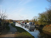
The route of the canal south from Kendal is still readily apparent, with most of the bridges remaining in place. Although severed by the motorway construction, it was not drained because the channel was used to supply water to a pipeline which ran from the canal near Garstang to a chemical works near Fleetwood. As a result, this section can still be used by small boats. In 1976, the Lancaster Canal Trust mounted a campaign for the construction of slipways on this section, to make the launching of boats easier, which proved to be successful, as they were used at Easter 1978, when a boat rally was held on the upper reaches.
During its working life, packet boats provided an express passenger service between Preston and Lancaster, and later to Kendal at 10 miles per hour (4.5 m/s), with passengers walking up or down the flight of locks at Tewitfield and embarking on a second boat. The seven-hour journey time halved the best speeds of stage coaches; because of the comfort of the journey, passengers stayed loyal to the packet boats even after the advent of railway competition in the 1840s.
The isolated northern part of the canal was finally connected to the rest of the English canal network in 2002 by the opening of the Ribble Link
.
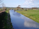
Most of the canal runs through open countryside except where it runs through the City of Lancaster. With the exception of the branch to Glasson Dock
and the Ribble Link, the navigable Preston to Tewitfield section of the canal follows the same elevation contour
on maps and is therefore free of locks.
The Kendal to Preston section now terminates at Ashton basin, but previously continued to the centre of Preston where there are a number of streets and pubs whose names give clues: Wharfe Street, Kendal Street, The Lamb and Packet (the lamb being the crest of Preston), The Fighting Cocks (formerly The Boatmans). Most of the ground formerly occupied by the canal basin is now the University of Central Lancashire
.
and Johnson's Hillock near Chorley
. However, by 1801, no design had even been agreed for the aqueduct over the River Ribble
, and in July 1801 it was agreed to build a temporary tramroad to cross the river and span the gap between the northern and southern parts of the canal. The double-track Lancaster Canal Tramroad
was opened in 1803 with three steam-worked inclined planes and a low trestle bridge across the Ribble. The canal was extended north from Johnson's Hillock to Walton Summit through a tunnel at Whittle Hills.
This temporary solution become permanent, and the aqueduct was never built. Although this section was the busiest on the canal, income was insufficient to pay for construction of the planned aqueduct.
 In 1792 the Lancaster obtained an act to link Kendal with Westhoughton
. They also petitioned to make an extension from Westhoughton to the Bridgewater Canal
near Worsley
but stopped when the occupant of Atherton Hall objected.
The Leeds and Liverpool Canal having reached Blackburn by 1810, a decision was made to link with the Lancaster Canal's southern end to avoid constructing a parallel waterway. The Lancaster Canal built two short branches to connect with the Leeds and Liverpool Canal, from Johnson's Hillock including seven locks, and from Bark Hill to Wigan Top Lock – the Act authorising this construction also authorised additional tolls to make it worthwhile for the Lancaster Canal to co-operate with the Leeds and Liverpool.
In 1851 the Lancaster Canal leased the tolls on the southern end to the Leeds and Liverpool Canal in return for an annual rent, and this agreement was made permanent in 1864.
The tramroad was closed from Bamber Bridge to Preston in 1864, and the remainder to Walton Summit in 1879. The canal between Walton Summit and the Leeds and Liverpool link at Johnson's Hillock was last used in 1932 (although a party in canoes managed to navigate the branch as late as 1969 with only two portage
s) This section was closed in the 1960s, as a result of the M61 motorway
proposal which would have required three bridges over the canal. The Ministry of Transport
and British Waterways Board decided that the cost of constructing the bridges was not justified, particularly as the canal was in poor condition, and promoted a bill in Parliament for closure of the canal. As a result, much is now buried under the M61 motorway
, and in the Clayton-le-Woods
area housing estates have been built on the route in the 1990s. The remainder of the southern end, between Johnson's Hillock and Wigan Top Lock, is now considered as part of the Leeds and Liverpool Canal and remains well used by leisure traffic.
near Tebay
: the final 5 miles (8 km) into Kendal are dry.
The Northern Reaches Restoration Group
(NRRG) and the Lancaster Canal Restoration Partnership aim to restore the canal from Tewitfield to Kendal. There are nine partners: British Waterways
, Cumbria County Council, Inland Waterways Association
, Kendal Town Council, Lancashire County Council
, City of Lancaster Council
, Lancaster Canal Trust
, South Lakeland District Council
, and The Waterways Trust.
The restoration will involve restoring the six places where the canal is culverted (including the three places where the M6 Motorway construction blocked the route), restoring Hincaster Tunnel, restoring the 5 dry miles, and a new crossing of the A590 road near Kendal, as well as many more minor works including work on 52 listed structures. The extensive engineering required will be expensive (a 2002 estimate being £60 million), and so restoration is planned to proceed in phases.
The first phase is planned to be restoration of 3.7 miles (6 km) southwards from Canal Head in Kendal to Natland Road. Funding of £750,000 was provided in 2005 for the planning and design of this first phase: construction works are not expected to commence before late 2007 with completion in 2009 at the earliest. Despite the projected 2009 completion date, the work to restore the canal had still not been started by late 2010.
The Grade 1 Listed Lune Aqueduct
was scheduled for a two million pound facelift in 2009/10. The organisations responsible for the aqueduct have been awarded £50,000 by the Heritage Lottery fund to enable them put together a credible bid for funding, but the work is not now expected to be completed until 2015.
Canal
Canals are man-made channels for water. There are two types of canal:#Waterways: navigable transportation canals used for carrying ships and boats shipping goods and conveying people, further subdivided into two kinds:...
in the north of England
England
England is a country that is part of the United Kingdom. It shares land borders with Scotland to the north and Wales to the west; the Irish Sea is to the north west, the Celtic Sea to the south west, with the North Sea to the east and the English Channel to the south separating it from continental...
, originally planned to run from Westhoughton
Westhoughton
Westhoughton is a town and civil parish of the Metropolitan Borough of Bolton in Greater Manchester, England. It is southwest of Bolton, east of Wigan and northwest of Manchester....
in Lancashire
Lancashire
Lancashire is a non-metropolitan county of historic origin in the North West of England. It takes its name from the city of Lancaster, and is sometimes known as the County of Lancaster. Although Lancaster is still considered to be the county town, Lancashire County Council is based in Preston...
to Kendal
Kendal
Kendal, anciently known as Kirkby in Kendal or Kirkby Kendal, is a market town and civil parish within the South Lakeland District of Cumbria, England...
in south Cumbria
Cumbria
Cumbria , is a non-metropolitan county in North West England. The county and Cumbria County Council, its local authority, came into existence in 1974 after the passage of the Local Government Act 1972. Cumbria's largest settlement and county town is Carlisle. It consists of six districts, and in...
(then in Westmorland
Westmorland
Westmorland is an area of North West England and one of the 39 historic counties of England. It formed an administrative county from 1889 to 1974, after which the entirety of the county was absorbed into the new county of Cumbria.-Early history:...
). The section around the crossing of the River Ribble
River Ribble
The River Ribble is a river that runs through North Yorkshire and Lancashire, in northern England. The river's drainage basin also includes parts of Greater Manchester around Wigan.-Geography:...
was never completed, and much of the southern end leased to the Leeds and Liverpool Canal
Leeds and Liverpool Canal
The Leeds and Liverpool Canal is a canal in Northern England, linking the cities of Leeds and Liverpool. Over a distance of , it crosses the Pennines, and includes 91 locks on the main line...
, of which it is now generally considered part.
Of the canal north of Preston, only the section from Preston to Tewitfield
Tewitfield
Tewitfield is a village in Lancashire, England, UK, near Borwick and Carnforth, and in the parish of Priest Hutton.Tewitfield Locks is the current terminus of the navigable Lancaster Canal, and the Lancaster Canal Trust, the Northern Reaches Restoration Group and others are campaigning for the...
near Carnforth
Carnforth
- References :...
in Lancashire
Lancashire
Lancashire is a non-metropolitan county of historic origin in the North West of England. It takes its name from the city of Lancaster, and is sometimes known as the County of Lancaster. Although Lancaster is still considered to be the county town, Lancashire County Council is based in Preston...
is currently open to navigation for 42 miles (67.6 km), with the canal north of Tewitfield having been severed in three places by the construction of the M6 motorway
M6 motorway
The M6 motorway runs from junction 19 of the M1 at the Catthorpe Interchange, near Rugby via Birmingham then heads north, passing Stoke-on-Trent, Manchester, Preston, Carlisle and terminating at the Gretna junction . Here, just short of the Scottish border it becomes the A74 which continues to...
, and by the A590 road
A590 road
The A590 is a trunk road in southern Cumbria, in the north-west of England. It runs north-east to south-west from M6 junction 36, through the towns of Ulverston and Barrow-in-Furness to terminate at Vickerstown on Walney Island. The road is a mixture of dual carriageway and single carriageway,...
near Kendal
Kendal
Kendal, anciently known as Kirkby in Kendal or Kirkby Kendal, is a market town and civil parish within the South Lakeland District of Cumbria, England...
. The southern part, from Johnson's Hillock to Wigan Top Lock, remains navigable as part of the Leeds and Liverpool Canal. The planned continuation to Westhoughton was never built.
History
John Longbotham
John Longbotham was a canal engineer and pupil of John Smeaton who in 1766 suggested a Leeds and Liverpool Canal and did a survey which was approved by James Brindley...
, Robert Dickinson and Richard Beck
Richard Beck
Richard Beck is an artist manager and former public relations man within the music industry. He runs Bigboy Management with a roster comprising RyanDan, 5ive and Vince Harder. He also presides over Supernova Entertainment Ltd, a live music and entertainment organisation...
resurveyed the proposed line, and a final survey was carried out later the same year by John Rennie.
In 1792 the promoters sought an Act of Parliament
Act of Parliament
An Act of Parliament is a statute enacted as primary legislation by a national or sub-national parliament. In the Republic of Ireland the term Act of the Oireachtas is used, and in the United States the term Act of Congress is used.In Commonwealth countries, the term is used both in a narrow...
urgently, as proposals by the Leeds and Liverpool Canal
Leeds and Liverpool Canal
The Leeds and Liverpool Canal is a canal in Northern England, linking the cities of Leeds and Liverpool. Over a distance of , it crosses the Pennines, and includes 91 locks on the main line...
to alter their route would have affected the profitability of the southern section. It received the Royal Assent
Royal Assent
The granting of royal assent refers to the method by which any constitutional monarch formally approves and promulgates an act of his or her nation's parliament, thus making it a law...
on 11 June 1792, and was entitled An Act for making and maintaining a navigable Canal, from Kirkby Kendal in the county of Westmoreland, to West Houghton in the county palatine of Lancaster, and also a navigable Branch from the said intended Canal at or near Barwick, to or near Warton Cragg, and also another navigable Branch, from, at or near, Galemoss, by Chorley, to or near Duxbury in the said county palatine of Lancaster.
The Act created the Company of Proprietors of the Lancaster Canal Navigation, and gave them powers to raise £414,100 by the issuing of shares, and an additional £200,000, either by mortgage or by issuing more shares, if required. John Rennie was appointed as Engineer in July 1792, with William Crossley the elder as his assistant, and Archibald Millar as resident engineer and superintendent. A second Act of Parliament was obtained in May 1793 to authorise the construction of the Glasson branch, so that the canal had a connection to the sea.
The northern end
Lune Aqueduct
The Lune Aqueduct is a navigable aqueduct that carries the Lancaster Canal over the River Lune, on the east side of the city of Lancaster in Lancashire, England. It is was completed in 1797 at a total cost of £48,320.18s.10d.It is a Grade I listed building....
, which was built of stone, although Rennie thought brick should have been used, as it would have been considerably cheaper. By 1797 the aqueduct
Aqueduct
An aqueduct is a water supply or navigable channel constructed to convey water. In modern engineering, the term is used for any system of pipes, ditches, canals, tunnels, and other structures used for this purpose....
was open, carrying the canal 62 feet (18.9 m) above the river, and boats were now able to travel the 42.4 miles (68.2 km) from Preston to Tewitfield. In 1813, work began on the canal north from Tewitfield, which was completed to Kendal in 1819. Construction on the 2.5 miles (4 km) Glasson Dock
Glasson Dock
Glasson Dock, also known as Glasson, is a village in England, south of Lancaster, at the mouth of the River Lune. It is in the City of Lancaster district of Lancashire.-History:...
branch began in 1819, and it opened in 1826, with six locks carrying the canal down to the sea.
With the coming of the railways, the proprietors sought to lease the canal to a railway company in 1860. After a Bill to authorise the arrangement with the London and North Western Railway
London and North Western Railway
The London and North Western Railway was a British railway company between 1846 and 1922. It was created by the merger of three companies – the Grand Junction Railway, the London and Birmingham Railway and the Manchester and Birmingham Railway...
was defeated in the House of Lords in 1863, it was reintroduced the following year, and became an Act of Parliament on 29 July 1864. The Canal Company then received £12665.87 per year for the lease of the northern end of the canal, which allowed them to continue paying dividends and to make investments. Eventually, the railway company offered to buy the canal, and this was formalised by an Act of Parliament obtained on 16 July 1885, although they actually took over the canal on 1 July.
The canal had always suffered problems with leakage due to limestone fissures in the bed, and in 1939 the London, Midland and Scottish Railway
London, Midland and Scottish Railway
The London Midland and Scottish Railway was a British railway company. It was formed on 1 January 1923 under the Railways Act of 1921, which required the grouping of over 120 separate railway companies into just four...
, who were by now owners of the canal, obtained an Act to close the first 0.5 mile (0.80467 km) section at Kendal.
In 1941-42 the by then unused section north of Kendal Gas Works was closed because of leakage, and the owners attempted to close the whole canal in 1944, but opposition in the House of Lords resulted in a stay of execution. In later years, the main commercial traffic was coal from Preston to Kendal Gas Works, which had been built in 1824 on land bought from the canal company, and between 6500 long ton were carried each year. As there was no railway to the gas works, this traffic had ensured the maintenance of the canal, but it was transferred to road vehicles in 1944, and the canal carried its final commercial traffic in 1947.
In 1955, an Act of Parliament authorised the closure of the canal, along with several others, covering 771 miles (1,240.8 km) in total. The Inland Waterways Association
Inland Waterways Association
The Inland Waterways Association was formed in 1946 as a registered charity in the United Kingdom to campaign for the conservation, use, maintenance, restoration and sensitive development of British Canals and river navigations....
organised several protest meetings, and the one held in Lancaster led to the formation of the Lancaster Canal Boat Club. One immediate effect was that it was drained of water north from Stainton because of leakage, and the last 2 miles (3.2 km) in Kendal were filled in. Although it was officially closed, pleasure boats continued to use the section below Tewitfield. Above the locks, a 100 yards (91.4 m) section at Burton was drained because of problems with leakage, and a pipe replaced the canal, so that the water supply to the lower canal was maintained. This effectively ended navigation north of Tewitfield, so that when the M6 motorway
M6 motorway
The M6 motorway runs from junction 19 of the M1 at the Catthorpe Interchange, near Rugby via Birmingham then heads north, passing Stoke-on-Trent, Manchester, Preston, Carlisle and terminating at the Gretna junction . Here, just short of the Scottish border it becomes the A74 which continues to...
was being constructed, the canal was culvert
Culvert
A culvert is a device used to channel water. It may be used to allow water to pass underneath a road, railway, or embankment. Culverts can be made of many different materials; steel, polyvinyl chloride and concrete are the most common...
ed in three places, despite a local campaign for bridges to be built, so that restoration would be possible in the future.
The route of the canal south from Kendal is still readily apparent, with most of the bridges remaining in place. Although severed by the motorway construction, it was not drained because the channel was used to supply water to a pipeline which ran from the canal near Garstang to a chemical works near Fleetwood. As a result, this section can still be used by small boats. In 1976, the Lancaster Canal Trust mounted a campaign for the construction of slipways on this section, to make the launching of boats easier, which proved to be successful, as they were used at Easter 1978, when a boat rally was held on the upper reaches.
During its working life, packet boats provided an express passenger service between Preston and Lancaster, and later to Kendal at 10 miles per hour (4.5 m/s), with passengers walking up or down the flight of locks at Tewitfield and embarking on a second boat. The seven-hour journey time halved the best speeds of stage coaches; because of the comfort of the journey, passengers stayed loyal to the packet boats even after the advent of railway competition in the 1840s.
The isolated northern part of the canal was finally connected to the rest of the English canal network in 2002 by the opening of the Ribble Link
Ribble Link
The Millennium Ribble Link is a Linear Water Park and new navigation which links the once-isolated Lancaster Canal in Lancashire, England to the River Ribble...
.
Most of the canal runs through open countryside except where it runs through the City of Lancaster. With the exception of the branch to Glasson Dock
Glasson Dock
Glasson Dock, also known as Glasson, is a village in England, south of Lancaster, at the mouth of the River Lune. It is in the City of Lancaster district of Lancashire.-History:...
and the Ribble Link, the navigable Preston to Tewitfield section of the canal follows the same elevation contour
Contour line
A contour line of a function of two variables is a curve along which the function has a constant value. In cartography, a contour line joins points of equal elevation above a given level, such as mean sea level...
on maps and is therefore free of locks.
The Kendal to Preston section now terminates at Ashton basin, but previously continued to the centre of Preston where there are a number of streets and pubs whose names give clues: Wharfe Street, Kendal Street, The Lamb and Packet (the lamb being the crest of Preston), The Fighting Cocks (formerly The Boatmans). Most of the ground formerly occupied by the canal basin is now the University of Central Lancashire
University of Central Lancashire
The University of Central Lancashire is a university based in Preston, Lancashire, England.The university has its roots in The Institution For The Diffusion Of Useful Knowledge which was founded in 1828. In 1992 it was granted University status by the Privy Council...
.
The tramway
By 1799, the canal was complete between Bark Hill near WiganWigan
Wigan is a town in Greater Manchester, England. It stands on the River Douglas, south-west of Bolton, north of Warrington and west-northwest of Manchester. Wigan is the largest settlement in the Metropolitan Borough of Wigan and is its administrative centre. The town of Wigan had a total...
and Johnson's Hillock near Chorley
Chorley
Chorley is a market town in Lancashire, in North West England. It is the largest settlement in the Borough of Chorley. The town's wealth came principally from the cotton industry...
. However, by 1801, no design had even been agreed for the aqueduct over the River Ribble
River Ribble
The River Ribble is a river that runs through North Yorkshire and Lancashire, in northern England. The river's drainage basin also includes parts of Greater Manchester around Wigan.-Geography:...
, and in July 1801 it was agreed to build a temporary tramroad to cross the river and span the gap between the northern and southern parts of the canal. The double-track Lancaster Canal Tramroad
Lancaster Canal Tramroad
The Lancaster Canal Tramroad, also known as the Walton Summit Tramway or the Old Tram Road, was completed in 1803 to link the north and south ends of the Lancaster Canal across the Ribble valley , pending completion of the canal. The canal link was never constructed.-History:The Lancaster Canal...
was opened in 1803 with three steam-worked inclined planes and a low trestle bridge across the Ribble. The canal was extended north from Johnson's Hillock to Walton Summit through a tunnel at Whittle Hills.
This temporary solution become permanent, and the aqueduct was never built. Although this section was the busiest on the canal, income was insufficient to pay for construction of the planned aqueduct.
The southern end
Westhoughton
Westhoughton is a town and civil parish of the Metropolitan Borough of Bolton in Greater Manchester, England. It is southwest of Bolton, east of Wigan and northwest of Manchester....
. They also petitioned to make an extension from Westhoughton to the Bridgewater Canal
Bridgewater Canal
The Bridgewater Canal connects Runcorn, Manchester and Leigh, in North West England. It was commissioned by Francis Egerton, 3rd Duke of Bridgewater, to transport coal from his mines in Worsley to Manchester...
near Worsley
Worsley
Worsley is a town in the metropolitan borough of the City of Salford, in Greater Manchester, England. It lies along the course of Worsley Brook, west of Manchester. The M60 motorway bisects the area....
but stopped when the occupant of Atherton Hall objected.
The Leeds and Liverpool Canal having reached Blackburn by 1810, a decision was made to link with the Lancaster Canal's southern end to avoid constructing a parallel waterway. The Lancaster Canal built two short branches to connect with the Leeds and Liverpool Canal, from Johnson's Hillock including seven locks, and from Bark Hill to Wigan Top Lock – the Act authorising this construction also authorised additional tolls to make it worthwhile for the Lancaster Canal to co-operate with the Leeds and Liverpool.
In 1851 the Lancaster Canal leased the tolls on the southern end to the Leeds and Liverpool Canal in return for an annual rent, and this agreement was made permanent in 1864.
The tramroad was closed from Bamber Bridge to Preston in 1864, and the remainder to Walton Summit in 1879. The canal between Walton Summit and the Leeds and Liverpool link at Johnson's Hillock was last used in 1932 (although a party in canoes managed to navigate the branch as late as 1969 with only two portage
Portage
Portage or portaging refers to the practice of carrying watercraft or cargo over land to avoid river obstacles, or between two bodies of water. A place where this carrying occurs is also called a portage; a person doing the carrying is called a porter.The English word portage is derived from the...
s) This section was closed in the 1960s, as a result of the M61 motorway
M61 motorway
The M61 motorway is a motorway in North West England. It runs from the M60 motorway northwest of Manchester and heads northwest past Bolton and Chorley to join the M6 just north of the junction between the M6 and M65 motorways to the south of Preston....
proposal which would have required three bridges over the canal. The Ministry of Transport
Department for Transport
In the United Kingdom, the Department for Transport is the government department responsible for the English transport network and a limited number of transport matters in Scotland, Wales and Northern Ireland which are not devolved...
and British Waterways Board decided that the cost of constructing the bridges was not justified, particularly as the canal was in poor condition, and promoted a bill in Parliament for closure of the canal. As a result, much is now buried under the M61 motorway
M61 motorway
The M61 motorway is a motorway in North West England. It runs from the M60 motorway northwest of Manchester and heads northwest past Bolton and Chorley to join the M6 just north of the junction between the M6 and M65 motorways to the south of Preston....
, and in the Clayton-le-Woods
Clayton-le-Woods
Clayton-le-Woods is a large village and civil parish of the Borough of Chorley, in Lancashire, England. According to the United Kingdom Census 2001 it has a population of 14,528.-Geography:...
area housing estates have been built on the route in the 1990s. The remainder of the southern end, between Johnson's Hillock and Wigan Top Lock, is now considered as part of the Leeds and Liverpool Canal and remains well used by leisure traffic.
Restoration
Long term plans are being developed to reopen the section north of Tewitfield, which is still in water for 9 miles (14.5 km), fed by Killington ReservoirKillington Beck
Killington Beck is a stream or beck in Cumbria, England about long. It starts at a height of about on Lambrigg Fell between Kendal and Sedbergh.About from its source it is dammed and forms the Killington Reservoir or Killington Lake...
near Tebay
Tebay
Tebay is a village and civil parish in Cumbria, England, within the traditional borders of Westmorland. It lies in the upper Lune Valley, at the head of the Lune Gorge. The parish of Tebay had a population of 728 recorded in the 2001 census,...
: the final 5 miles (8 km) into Kendal are dry.
The Northern Reaches Restoration Group
Northern Reaches Restoration Group
The Northern Reaches Restoration Group is a waterway society in Lancashire and Cumbria, England, UK.It is concerned with the re-opening of the Northern Reaches of the Lancaster Canal, a 14 mile stretch from Tewitfield Locks to Canal Head at Kendal...
(NRRG) and the Lancaster Canal Restoration Partnership aim to restore the canal from Tewitfield to Kendal. There are nine partners: British Waterways
British Waterways
British Waterways is a statutory corporation wholly owned by the government of the United Kingdom, serving as the navigation authority in England, Scotland and Wales for the vast majority of the canals as well as a number of rivers and docks...
, Cumbria County Council, Inland Waterways Association
Inland Waterways Association
The Inland Waterways Association was formed in 1946 as a registered charity in the United Kingdom to campaign for the conservation, use, maintenance, restoration and sensitive development of British Canals and river navigations....
, Kendal Town Council, Lancashire County Council
Lancashire County Council
Lancashire County Council is the upper-tier local authority for the non-metropolitan county of Lancashire, England. It currently consists of 84 councillors, and is controlled by the Conservative Party, who won control of the council in the local council elections in June 2009, ending 28 years of...
, City of Lancaster Council
City of Lancaster
The City of Lancaster , is a local government district of Lancashire, England, with the status of a city and non-metropolitan district. It is named after its largest settlement, Lancaster, but covers a far larger area which includes the towns of Morecambe, Heysham, and Carnforth, as well as...
, Lancaster Canal Trust
Lancaster Canal Trust
The Lancaster Canal Trust is a waterway society and a registered charity on the Lancaster Canal in Lancashire and Cumbria, England UK.It was formed in 1963 as the Association for the Restoration of the Lancaster Canal, and its main aim is the restoration and reopening for navigation of the stretch...
, South Lakeland District Council
South Lakeland
South Lakeland is a local government district in Cumbria, England. Its council is based in Kendal. It includes much of the Lake District.The district was created on 1 April 1974 under the Local Government Act 1972...
, and The Waterways Trust.
The restoration will involve restoring the six places where the canal is culverted (including the three places where the M6 Motorway construction blocked the route), restoring Hincaster Tunnel, restoring the 5 dry miles, and a new crossing of the A590 road near Kendal, as well as many more minor works including work on 52 listed structures. The extensive engineering required will be expensive (a 2002 estimate being £60 million), and so restoration is planned to proceed in phases.
The first phase is planned to be restoration of 3.7 miles (6 km) southwards from Canal Head in Kendal to Natland Road. Funding of £750,000 was provided in 2005 for the planning and design of this first phase: construction works are not expected to commence before late 2007 with completion in 2009 at the earliest. Despite the projected 2009 completion date, the work to restore the canal had still not been started by late 2010.
The Grade 1 Listed Lune Aqueduct
Lune Aqueduct
The Lune Aqueduct is a navigable aqueduct that carries the Lancaster Canal over the River Lune, on the east side of the city of Lancaster in Lancashire, England. It is was completed in 1797 at a total cost of £48,320.18s.10d.It is a Grade I listed building....
was scheduled for a two million pound facelift in 2009/10. The organisations responsible for the aqueduct have been awarded £50,000 by the Heritage Lottery fund to enable them put together a credible bid for funding, but the work is not now expected to be completed until 2015.