
A590 road
Encyclopedia
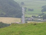
The A590 is a trunk road
in southern Cumbria
, in the north-west
of England
. It runs north-east to south-west from M6
junction 36, through the towns of Ulverston
and Barrow-in-Furness
to terminate at Vickerstown
on Walney Island
. The road is a mixture of dual carriageway
and single carriageway
, with the section east of Low Newton, Cumbria
to the M6 being mainly dual. Further dual sections are south of Newby Bridge
, south of Greenodd
and south of Ulverston
. The road is the main route for tourists entering the southern Lake District
. It has often humorously been described as "the longest cul-de-sac in the world".
. Its route followed a number of country roads via a series of Turn Off To Stay On (TOTSO)'s, passing through a number of villages including Lindale, High
and Low Newton
, Newby Bridge
and Greenodd
into the larger town of Ulverston
. This road formed a large part of the southern boundary of the Lake District
upon its formation in 1951.
This stretch of road has now undergone a series of improvements and route alignments. In the mid 1970s, the A591
'Kendal
link road' was built between Junction 36 of the M6 and Kendal with an extension of the A590 also being constructed to join this as part of the wider Lancashire
expressways plans. This improvement to the A590 also included a realignment and dualling of the road to the west as far as High Newton, by-passing Lindale. In the mid 1990s the A590 was extended eastward through a re-numbering of the A591 between Sizergh and the M6, providing a single road between Barrow-in-Furness and the M6.
West of the Lindale bypass is the road's most recent improvement, a 2.4-mile (3.8-kilometre) long stretch of dual carriageway built to bypass High and Low Newton at a cost of £35.3 million. This new stretch of road was constructed to a high environmental standard and achieved a CEEQUAL
Award following its opening in Spring 2008. It connects to the original route to the east of Newby Bridge. The A590 reaches its most northern point at the foot of Windermere, before following the route of the River Leven to its estuary at Greenodd. Both the villages of Backbarrow and Greenodd have now been by-passed, though parts of this route remain narrow and windy. West of Greenodd the road switches between periods of single and dual carraigeway.
, the A590 follows an entirely different route to that it did prior to the early 1990s when Dalton was bypassed. Previously, the road had gone through Dalton and entered Barrow along the wide Victorian
Abbey Road, before passing through Barrow's shipyard onto Barrow Island.
As of 1992, the road now follows a modern bypass close to the South Lakes Wild Animal Park
and enters Barrow via its north-western industrial area, parallel to Walney Island
passing the site of Barrow's former iron
and steel
works. A one way
system opened in April 2008 now applies to the road as it passes closest to the center of Barrow, with westbound traffic heading towards the town center at Craven Park
roundabout and eastbound traffic continuing through the industrial land alongside Walney Channel. The road continues westward over the Jubilee Bridge
onto Walney Island
and terminates at the Irish Sea
Trunk road
A trunk road, trunk highway, or strategic road is a major road—usually connecting two or more cities, ports, airports, and other things.—which is the recommended route for long-distance and freight traffic...
in southern Cumbria
Cumbria
Cumbria , is a non-metropolitan county in North West England. The county and Cumbria County Council, its local authority, came into existence in 1974 after the passage of the Local Government Act 1972. Cumbria's largest settlement and county town is Carlisle. It consists of six districts, and in...
, in the north-west
North West England
North West England, informally known as The North West, is one of the nine official regions of England.North West England had a 2006 estimated population of 6,853,201 the third most populated region after London and the South East...
of England
England
England is a country that is part of the United Kingdom. It shares land borders with Scotland to the north and Wales to the west; the Irish Sea is to the north west, the Celtic Sea to the south west, with the North Sea to the east and the English Channel to the south separating it from continental...
. It runs north-east to south-west from M6
M6 motorway
The M6 motorway runs from junction 19 of the M1 at the Catthorpe Interchange, near Rugby via Birmingham then heads north, passing Stoke-on-Trent, Manchester, Preston, Carlisle and terminating at the Gretna junction . Here, just short of the Scottish border it becomes the A74 which continues to...
junction 36, through the towns of Ulverston
Ulverston
Ulverston is a market town and civil parish in the South Lakeland district of Cumbria in north-west England. Historically part of Lancashire, the town is located in the Furness area, close to the Lake District, and just north of Morecambe Bay....
and Barrow-in-Furness
Barrow-in-Furness
Barrow-in-Furness is an industrial town and seaport which forms about half the territory of the wider Borough of Barrow-in-Furness in the county of Cumbria, England. It lies north of Liverpool, northwest of Manchester and southwest from the county town of Carlisle...
to terminate at Vickerstown
Vickerstown
Vickerstown is an area located on the Isle of Walney, near to the mainland town of Barrow-in-Furness, England. Albeit not part of mainland Cumbria, Vickerstown is still regarded as part of the town of Barrow-in-Furness. It is an example of a planned estate built for workers by a company needing to...
on Walney Island
Walney Island
The Isle of Walney, also known as Walney Island, is an island in the United Kingdom which lies off the west coast of England, at the northern tip of Morecambe Bay. It forms part of the Borough of Barrow-in-Furness, and it is separated from the mainland at Barrow by Walney Channel, a narrow channel...
. The road is a mixture of dual carriageway
Dual carriageway
A dual carriageway is a class of highway with two carriageways for traffic travelling in opposite directions separated by a central reservation...
and single carriageway
Single carriageway
A single carriageway is a road with 1, 2 or more lanes arranged within a single carriageway with no central reservation to separate opposing flows of traffic. Two-lane road or two-lane highway are single carriageway with one lane for each direction...
, with the section east of Low Newton, Cumbria
Low Newton, Cumbria
Low Newton is a hamlet in the South Lakeland District, in the county of Cumbria, England. It was on the A590 road until it was by-passed a few years ago, it was opeded on Tuesday 8th April 2008...
to the M6 being mainly dual. Further dual sections are south of Newby Bridge
Newby Bridge
Newby Bridge is a small hamlet in the Lake District, Cumbria, although historically it was in Lancashire.Newby Bridge is located several miles west of Grange-over-Sands and is on the River Leven, close to the southern end of Windermere...
, south of Greenodd
Greenodd
Greenodd is a village in the Furness area of the county of Cumbria but within the historical county of Lancashire. For local government purposes the village is also within the area of South Lakeland District. It is located 3 miles north-east of Ulverston at the junction of the A590 trunk road and...
and south of Ulverston
Ulverston
Ulverston is a market town and civil parish in the South Lakeland district of Cumbria in north-west England. Historically part of Lancashire, the town is located in the Furness area, close to the Lake District, and just north of Morecambe Bay....
. The road is the main route for tourists entering the southern Lake District
Lake District
The Lake District, also commonly known as The Lakes or Lakeland, is a mountainous region in North West England. A popular holiday destination, it is famous not only for its lakes and its mountains but also for its associations with the early 19th century poetry and writings of William Wordsworth...
. It has often humorously been described as "the longest cul-de-sac in the world".
M6 to Ulverston
From east to west, the A590 originally terminated at the A6 road near LevensLevens, Cumbria
Levens is a village and civil parish in the South Lakeland district of the English county of Cumbria. It has a population of 1,007. The village lies south of Kendal off the A6 and A590 roads. Levens Hall is within the parish.- External links :**...
. Its route followed a number of country roads via a series of Turn Off To Stay On (TOTSO)'s, passing through a number of villages including Lindale, High
High Newton
For the place in Northumberland see High Newton-by-the-Sea.High Newton is a village in the South Lakeland District, in the county of Cumbria.- By-pass :...
and Low Newton
Low Newton, Cumbria
Low Newton is a hamlet in the South Lakeland District, in the county of Cumbria, England. It was on the A590 road until it was by-passed a few years ago, it was opeded on Tuesday 8th April 2008...
, Newby Bridge
Newby Bridge
Newby Bridge is a small hamlet in the Lake District, Cumbria, although historically it was in Lancashire.Newby Bridge is located several miles west of Grange-over-Sands and is on the River Leven, close to the southern end of Windermere...
and Greenodd
Greenodd
Greenodd is a village in the Furness area of the county of Cumbria but within the historical county of Lancashire. For local government purposes the village is also within the area of South Lakeland District. It is located 3 miles north-east of Ulverston at the junction of the A590 trunk road and...
into the larger town of Ulverston
Ulverston
Ulverston is a market town and civil parish in the South Lakeland district of Cumbria in north-west England. Historically part of Lancashire, the town is located in the Furness area, close to the Lake District, and just north of Morecambe Bay....
. This road formed a large part of the southern boundary of the Lake District
Lake District
The Lake District, also commonly known as The Lakes or Lakeland, is a mountainous region in North West England. A popular holiday destination, it is famous not only for its lakes and its mountains but also for its associations with the early 19th century poetry and writings of William Wordsworth...
upon its formation in 1951.
This stretch of road has now undergone a series of improvements and route alignments. In the mid 1970s, the A591
A591 road
The A591 is a major road in Cumbria, in the north-west of England. The stretch of the road between Windermere and Keswick has been voted Britain's Favourite Road.-Route:...
'Kendal
Kendal
Kendal, anciently known as Kirkby in Kendal or Kirkby Kendal, is a market town and civil parish within the South Lakeland District of Cumbria, England...
link road' was built between Junction 36 of the M6 and Kendal with an extension of the A590 also being constructed to join this as part of the wider Lancashire
Lancashire
Lancashire is a non-metropolitan county of historic origin in the North West of England. It takes its name from the city of Lancaster, and is sometimes known as the County of Lancaster. Although Lancaster is still considered to be the county town, Lancashire County Council is based in Preston...
expressways plans. This improvement to the A590 also included a realignment and dualling of the road to the west as far as High Newton, by-passing Lindale. In the mid 1990s the A590 was extended eastward through a re-numbering of the A591 between Sizergh and the M6, providing a single road between Barrow-in-Furness and the M6.
West of the Lindale bypass is the road's most recent improvement, a 2.4-mile (3.8-kilometre) long stretch of dual carriageway built to bypass High and Low Newton at a cost of £35.3 million. This new stretch of road was constructed to a high environmental standard and achieved a CEEQUAL
CEEQUAL
CEEQUAL, is an assessment and awards scheme for improving sustainability in civil engineering and public realm projects, based in the United Kingdom. It is promoted by the Institution of Civil Engineers and a group of civil engineering organisations including CIRIA, CECA and ACE...
Award following its opening in Spring 2008. It connects to the original route to the east of Newby Bridge. The A590 reaches its most northern point at the foot of Windermere, before following the route of the River Leven to its estuary at Greenodd. Both the villages of Backbarrow and Greenodd have now been by-passed, though parts of this route remain narrow and windy. West of Greenodd the road switches between periods of single and dual carraigeway.
Ulverston-Walney Island
The A590 passes through Ulverston, avoiding its most central streets, along an inner relief road. West of Ulverston the road is entirely single carriageway and is mainly used for commuting between Ulverston, Barrow-in-Furness and the small towns in-between the two. West of Dalton-in-FurnessDalton-in-Furness
Dalton-in-Furness is a small town of 8,394 people, north east of Barrow-in-Furness, in Cumbria, England.-History:Dalton is mentioned in the Domesday Book, written as "Daltune" as one of the townships forming the Manor of Hougun held by Earl Tostig. Historically, it was the capital of Furness...
, the A590 follows an entirely different route to that it did prior to the early 1990s when Dalton was bypassed. Previously, the road had gone through Dalton and entered Barrow along the wide Victorian
Victorian era
The Victorian era of British history was the period of Queen Victoria's reign from 20 June 1837 until her death on 22 January 1901. It was a long period of peace, prosperity, refined sensibilities and national self-confidence...
Abbey Road, before passing through Barrow's shipyard onto Barrow Island.
As of 1992, the road now follows a modern bypass close to the South Lakes Wild Animal Park
South Lakes Wild Animal Park
South Lakes Wild Animal Park is a zoo established in 1994 by David Gill, and located in Dalton-in-Furness, Cumbria, England.The park is a member of the European Association of Zoos and Aquaria and bills itself as one of the best conservation zoos in the country.-History:The zoo was opened by...
and enters Barrow via its north-western industrial area, parallel to Walney Island
Walney Island
The Isle of Walney, also known as Walney Island, is an island in the United Kingdom which lies off the west coast of England, at the northern tip of Morecambe Bay. It forms part of the Borough of Barrow-in-Furness, and it is separated from the mainland at Barrow by Walney Channel, a narrow channel...
passing the site of Barrow's former iron
Iron
Iron is a chemical element with the symbol Fe and atomic number 26. It is a metal in the first transition series. It is the most common element forming the planet Earth as a whole, forming much of Earth's outer and inner core. It is the fourth most common element in the Earth's crust...
and steel
Steel
Steel is an alloy that consists mostly of iron and has a carbon content between 0.2% and 2.1% by weight, depending on the grade. Carbon is the most common alloying material for iron, but various other alloying elements are used, such as manganese, chromium, vanadium, and tungsten...
works. A one way
One-way traffic
One-way traffic is traffic that moves in a single direction. A one-way street is a street either facilitating only one-way traffic, or designed to direct vehicles to move in one direction.-General signs:...
system opened in April 2008 now applies to the road as it passes closest to the center of Barrow, with westbound traffic heading towards the town center at Craven Park
Craven Park
There are two rugby league grounds in Britain and an area of London called Craven Park:* Craven Park , home of Barrow * Craven Park, Hull, current home of Hull Kingston Rovers...
roundabout and eastbound traffic continuing through the industrial land alongside Walney Channel. The road continues westward over the Jubilee Bridge
Walney Bridge
Walney Bridge is a bridge in Cumbria, England that connects Barrow-in-Furness on the British mainland to Walney Island.-History:...
onto Walney Island
Walney Island
The Isle of Walney, also known as Walney Island, is an island in the United Kingdom which lies off the west coast of England, at the northern tip of Morecambe Bay. It forms part of the Borough of Barrow-in-Furness, and it is separated from the mainland at Barrow by Walney Channel, a narrow channel...
and terminates at the Irish Sea
Irish Sea
The Irish Sea separates the islands of Ireland and Great Britain. It is connected to the Celtic Sea in the south by St George's Channel, and to the Atlantic Ocean in the north by the North Channel. Anglesey is the largest island within the Irish Sea, followed by the Isle of Man...