

La Matanza de Acentejo
Encyclopedia
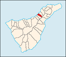
| La Matanza de Acentejo | |
| Map | |
|---|---|
 |
|
| Statistics | |
| Autonomous region: | Canary Islands Canary Islands The Canary Islands , also known as the Canaries , is a Spanish archipelago located just off the northwest coast of mainland Africa, 100 km west of the border between Morocco and the Western Sahara. The Canaries are a Spanish autonomous community and an outermost region of the European Union... |
| Province: | Santa Cruz de Tenerife Santa Cruz de Tenerife (province) Province of Santa Cruz de Tenerife also Province of Santa Cruz is a province of Spain, consisting of the western part of the autonomous community of the Canary Islands. It consists of about half of the Atlantic archipelago, including the islands of Tenerife, La Gomera, El Hierro, and La Palma, and... |
| Island: | Tenerife Tenerife Tenerife is the largest and most populous island of the seven Canary Islands, it is also the most populated island of Spain, with a land area of 2,034.38 km² and 906,854 inhabitants, 43% of the total population of the Canary Islands. About five million tourists visit Tenerife each year, the... |
| Area Area Area is a quantity that expresses the extent of a two-dimensional surface or shape in the plane. Area can be understood as the amount of material with a given thickness that would be necessary to fashion a model of the shape, or the amount of paint necessary to cover the surface with a single coat... : |
14.11 km² some reads 14.79 km² |
| Population Population A population is all the organisms that both belong to the same group or species and live in the same geographical area. The area that is used to define a sexual population is such that inter-breeding is possible between any pair within the area and more probable than cross-breeding with individuals... : |
7,587 (2001) |
| Population density Population density Population density is a measurement of population per unit area or unit volume. It is frequently applied to living organisms, and particularly to humans... : |
512.98/km² |
| Elevation Elevation The elevation of a geographic location is its height above a fixed reference point, most commonly a reference geoid, a mathematical model of the Earth's sea level as an equipotential gravitational surface .... : Lowest: Centre: Highest: |
Atlantic Ocean Atlantic Ocean The Atlantic Ocean is the second-largest of the world's oceanic divisions. With a total area of about , it covers approximately 20% of the Earth's surface and about 26% of its water surface area... 520 m southeastern part |
| Location Geographic coordinate system A geographic coordinate system is a coordinate system that enables every location on the Earth to be specified by a set of numbers. The coordinates are often chosen such that one of the numbers represent vertical position, and two or three of the numbers represent horizontal position... : |
28.41667/28°25' N lat. 16.433/16°26' W long. |
| Municipal code: | E-38025 |
| Website: | www.matanceros.com/inicio.htm |
La Matanza de Acentejo (Spanish
Spanish language
Spanish , also known as Castilian , is a Romance language in the Ibero-Romance group that evolved from several languages and dialects in central-northern Iberia around the 9th century and gradually spread with the expansion of the Kingdom of Castile into central and southern Iberia during the...
meaning Slaughter of Acentejo in which the Spanish won in 1494) is located on the north coast of Tenerife
Tenerife
Tenerife is the largest and most populous island of the seven Canary Islands, it is also the most populated island of Spain, with a land area of 2,034.38 km² and 906,854 inhabitants, 43% of the total population of the Canary Islands. About five million tourists visit Tenerife each year, the...
. It is located 15 km E of Puerto de la Cruz, about 23 km SSW of the island's capital, Santa Cruz de Tenerife
Santa Cruz de Tenerife
Santa Cruz de Tenerife is the capital , second-most populous city of the Autonomous Community of the Canary Islands and the 21st largest city in Spain, with a population of 222,417 in 2009...
, NE of Los Cristianos and Las Américas of Arona and WSW of the Tenerife North Airport.
The population is 7,490 (ISTAC, 2003), its density is 448.77/km² and the area is 14.11 km². The elevation is 520 m. Santa Úrsula is linked with the TF2 superhighway and the old highway linking Icod de los Vinos and the capital. Farmlands are in the valley areas and within the Atlantic, urban areas covers much of the area and the mountain and the hills are to the south. Its climate is vegetation.
Much of the area were made up of farmlands, most of the farmlands are urbanized while most of the population shifted from rural to urban and tourism. The population are mainly urban today and its industry are agriculture and tourism.
History
In historic times before the arrival of the SpaniardsSpain
Spain , officially the Kingdom of Spain languages]] under the European Charter for Regional or Minority Languages. In each of these, Spain's official name is as follows:;;;;;;), is a country and member state of the European Union located in southwestern Europe on the Iberian Peninsula...
, Acentejo was part of the menceyato (kingdom) of Taoro. The first
First Battle of Acentejo
The First Battle of Acentejo took place on the island of Tenerife between the Guanches and an alliance of Spaniards, other Europeans, and associated natives , on May 31, 1494, during the Spanish conquest of this island...
and the second
Second Battle of Acentejo
The Second Battle of Acentejo was a battle that took place on December 25, 1494, between the invading Spanish forces and the natives of the island of Tenerife, known as Guanches...
battles of Acentejo took place in 1494. The Spanish under Alonso Fernández de Lugo
Alonso Fernández de Lugo
Javier Alonso Luis Fernández de Lugo was a Spanish military man, conquistador, city founder, and administrator. He conquered the islands of La Palma and Tenerife for the Castilian Crown; they were the last of the Canary Islands to be conquered by Europeans. He was also the founder of the towns...
suffered a terrible defeat at this first battle, at the place now called La Matanza ("The Slaughter"). It occurred in present-day Barranco de San Antonio, which the Guanches called Farfan. The second battle resulted in a victory for the Spaniards, in which the town of La Victoria de Acentejo
La Victoria de Acentejo
La Victoria de Acentejo is located on the north coast of Tenerife. It is located 12 km E of Puerto de la Cruz, about 26 km SSW of the capital, Santa Cruz de Tenerife , and 15km from Tenerife North Airport.La Victoria is linked by the TF5 Motorway and the old highway to Icod de los Vinos and the...
was founded.
- Barrio Abajo
- Barrio Arriba
- Montañés
- Los Almendros
- Mayordomo
- San Antonio
Currently under construction is a scale replica of the interior of the Holy Sepulchre in Jerusalem (the place where according to Christian
Christian
A Christian is a person who adheres to Christianity, an Abrahamic, monotheistic religion based on the life and teachings of Jesus of Nazareth as recorded in the Canonical gospels and the letters of the New Testament...
tradition, was taken the body of Jesus Christ after his crucifixion), the replica will be located in the plaza of El Salvador's municipality. In this room is to also place a replica of the Shroud of Turin
Shroud of Turin
The Shroud of Turin or Turin Shroud is a linen cloth bearing the image of a man who appears to have suffered physical trauma in a manner consistent with crucifixion. It is kept in the royal chapel of the Cathedral of Saint John the Baptist in Turin, northern Italy. The image on the shroud is...
(Italy
Italy
Italy , officially the Italian Republic languages]] under the European Charter for Regional or Minority Languages. In each of these, Italy's official name is as follows:;;;;;;;;), is a unitary parliamentary republic in South-Central Europe. To the north it borders France, Switzerland, Austria and...
).
Historical population
| Year | Population | Change |
|---|---|---|
| 1991 | 5,887 | – |
| 1996 | 6,451 | – |
| 2001 | 7,053 | 502.78/km² |
| 2002 | 7,378 | – |
| 2003 | 7,490 | 530.83/km² |
| 2004 | 7,587 | 512.98/km² |
Other
La Matanza de Acentejo has schools, a few lyceums, a gymnasium, churches, a post office and a few plazaPlaza
Plaza is a Spanish word related to "field" which describes an open urban public space, such as a city square. All through Spanish America, the plaza mayor of each center of administration held three closely related institutions: the cathedral, the cabildo or administrative center, which might be...
s.
External links
- Map and aerial photos
- Street map: Street map from Mapquest, MapPoint or Google
- Satellite images: Google
- Coordinates: 28°25′0"N 16°28′0"W
See also
- TenerifeTenerifeTenerife is the largest and most populous island of the seven Canary Islands, it is also the most populated island of Spain, with a land area of 2,034.38 km² and 906,854 inhabitants, 43% of the total population of the Canary Islands. About five million tourists visit Tenerife each year, the...
- List of municipalities in Santa Cruz de Tenerife