
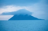
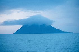
Kayak Island
Encyclopedia
Gulf of Alaska
The Gulf of Alaska is an arm of the Pacific Ocean defined by the curve of the southern coast of Alaska, stretching from the Alaska Peninsula and Kodiak Island in the west to the Alexander Archipelago in the east, where Glacier Bay and the Inside Passage are found.The entire shoreline of the Gulf is...
, 100 km (62 mi) SE of Cordova, Alaska
Cordova, Alaska
As of the census of 2000, there were 2,454 people, 958 households, and 597 families residing in the city. The population density was 40.0 per square mile . There are 1,099 housing units at an average density of 17.9 per square mile...
Malaspina Coastal Plain. It has a land area of 73.695 km² (28.454 sq mi) and no population.
It was named "Kayak
Kayak
A kayak is a small, relatively narrow, human-powered boat primarily designed to be manually propelled by means of a double blade paddle.The traditional kayak has a covered deck and one or more cockpits, each seating one paddler...
" in 1826 by Lt. Sarichef of the Russian Navy, because of the fancied resemblance of its outline to the Eskimo
Eskimo
Eskimos or Inuit–Yupik peoples are indigenous peoples who have traditionally inhabited the circumpolar region from eastern Siberia , across Alaska , Canada, and Greenland....
skin canoe. This island, it is believed, was the one Vitus Bering
Vitus Bering
Vitus Jonassen Bering Vitus Jonassen Bering Vitus Jonassen Bering (also, less correNavy]], a captain-komandor known among the Russian sailors as Ivan Ivanovich. He is noted for being the first European to discover Alaska and its Aleutian Islands...
saw and named "Saint Elias" in 1741.
According to the U.S. National Park Service, "Here naturalist Georg W. Steller, surgeon aboard Vitus Bering's ST. PETER, made the first attempts at contact between Europeans and Alaskan natives. His investigations are among the first contributions to the West's knowledge of the natural and human history of the region."
Captain James Cook
James Cook
Captain James Cook, FRS, RN was a British explorer, navigator and cartographer who ultimately rose to the rank of captain in the Royal Navy...
visited the island on May 12, 1778, and buried a bottle with a paper and two small pieces of silver given to him by Dr. Richard Kaye, the chaplain of King George III
George III of the United Kingdom
George III was King of Great Britain and King of Ireland from 25 October 1760 until the union of these two countries on 1 January 1801, after which he was King of the United Kingdom of Great Britain and Ireland until his death...
, for this purpose. Because of this, Capt. Cook gave the name "Kaye's Island" to this feature. It was called "Nuestra Senora del Carmen" or "Isla del Carmen," meaning "Our Lady Carmen" or "Island of (Our Lady) Carmen" by Don I. Arteaga about July 16, 1779, for the saint to whom this day was dedicated.
The Bering Expedition Landing Site was declared a National Historic Landmark
National Historic Landmark
A National Historic Landmark is a building, site, structure, object, or district, that is officially recognized by the United States government for its historical significance...
in 1978.
Cape Saint Elias
Cape Saint Elias
Cape Saint Elias is a cape in the U.S. state of Alaska. It is located at the southwest end of Kayak Island, 104 km southeast of Cordova, at . It is commonly believed that Mount Saint Elias, the second highest mountain in the United States and Canada, is named for this landform.The cape was...
is located on the southwest end of the island. Mount Saint Elias
Mount Saint Elias
Mount Saint Elias, also designated Boundary Peak 186, is the second highest mountain in both Canada and the United States, being situated on the Yukon and Alaska border. It lies about southwest of Mount Logan, the highest mountain in Canada. The Canadian side is part of Kluane National Park,...
— about 115 miles to the ENE, and at 18,009 feet (5,489 m) the second highest mountain in both the United States
United States
The United States of America is a federal constitutional republic comprising fifty states and a federal district...
and Canada
Canada
Canada is a North American country consisting of ten provinces and three territories. Located in the northern part of the continent, it extends from the Atlantic Ocean in the east to the Pacific Ocean in the west, and northward into the Arctic Ocean...
— was likely named after this cape.
The Cape St. Elias Light
Cape St. Elias Light
-History:Congress approved the construction of a light station at Cape St. Elias in October 1913, appropriating $115,000 for the construction. construction began in 1915 and a third order Fresnel lens was installed. In 1927 the station was equipped with radio beacon facilities, which was the second...
is an important aid-to-navigation located on the island.
External links
- Kayak Island: Block 1191, Census Tract 2, Valdez-Cordova Census Area, Alaska United States Census Bureau