
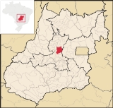
Jaraguá
Encyclopedia
| Jaraguá | |
|---|---|
| State | Goiás Goiás Goiás is a state of Brazil, located in the central part of the country. The name Goiás comes from the name of an indigenous community... |
| Coordinates: | 15°44′23"S 49°20′05"W |
| Area: | 1,888.9 km² |
| Population: | 38,968 (IBGE 2007) |
| Elevation: | 666 m above sea level |
| Postcode (CEP): | 76330-000 |
| Became a city: | 1882 |
| Distance to Goiânia Goiânia -Climate:The city has a tropical wet and dry climate with an average temperature of . There's a wet season, from October to April, and a dry one, from May to September. Annual rainfall is around 1,520 mm.... : |
124 km |
| IBGE statistical microregion: | Anápolis Microregion Anápolis Microregion The Anápolis Microregion is a region of central Goiás state, Brazil, including municipalities surrounding the city of Anápolis. For a map see *Population: 517,221 inhabitants *Cities: 19*Total Area: 8,386.80 km²... |
| Website: | n/a |
City
A city is a relatively large and permanent settlement. Although there is no agreement on how a city is distinguished from a town within general English language meanings, many cities have a particular administrative, legal, or historical status based on local law.For example, in the U.S...
and municipality
Municipality
A municipality is essentially an urban administrative division having corporate status and usually powers of self-government. It can also be used to mean the governing body of a municipality. A municipality is a general-purpose administrative subdivision, as opposed to a special-purpose district...
in central Goiás
Goiás
Goiás is a state of Brazil, located in the central part of the country. The name Goiás comes from the name of an indigenous community...
state, Brazil
Brazil
Brazil , officially the Federative Republic of Brazil , is the largest country in South America. It is the world's fifth largest country, both by geographical area and by population with over 192 million people...
. It is a regional center and a producer of agricultural products, clothing, and cattle.
Location and connections
Considered to be the national capital of the clothing industry, Jaraguá is in the Vale do São Patrício on the important Belém-Brasília highway (BR-153). It is 124 km from the state capital of GoiâniaGoiânia
-Climate:The city has a tropical wet and dry climate with an average temperature of . There's a wet season, from October to April, and a dry one, from May to September. Annual rainfall is around 1,520 mm....
and 230 km from the federal capital of Brasília
Brasília
Brasília is the capital city of Brazil. The name is commonly spelled Brasilia in English. The city and its District are located in the Central-West region of the country, along a plateau known as Planalto Central. It has a population of about 2,557,000 as of the 2008 IBGE estimate, making it the...
. Anápolis
Anápolis
Anápolis is the third largest city in the State of Goiás in Brazil. It lies in the center of a rich agricultural region and has become a leader in food processing and pharmaceutical plants.-Location and population:...
, the second largest city in the state of Goiás, lies 90 km to the south.
Highway connections from Goiânia
Goiânia
-Climate:The city has a tropical wet and dry climate with an average temperature of . There's a wet season, from October to April, and a dry one, from May to September. Annual rainfall is around 1,520 mm....
are made by GO-080 / Nerópolis
Nerópolis
Nerópolis is a small city and municipality in central Goiás state, Brazil.-Location:The municipality is part of the metropolitan region of Goiânia, which is 42 kilometers to the west. It is nationally known as the city of garlic and sweets...
/ São Francisco de Goiás
São Francisco de Goiás
São Francisco de Goiás is a small town and municipality in central Goiás state, Brazil.Municipal boundaries:*North: Jaraguá*South: Petrolina de Goiás*East: Pirenópolis*West: Jesúpolis and Jaraguá...
/ BR-153 /. For a complete list of distances and highway connections in the state of Goiás
Goiás
Goiás is a state of Brazil, located in the central part of the country. The name Goiás comes from the name of an indigenous community...
see Seplan
Municipal boundaries
GoianésiaGoianésia
Goianésia is a municipality in the state of Goiás, Brazil. It is a large producer of sugarcane for production of alcohol used as a source of fuel.-Location:...
, Itaguari
Itaguari
Itaguari is a small town and municipality in central Goiás state, Brazil.-Location and Connections:The distance to the state capital is 109 km., while the distance to the regional center is 116 km....
, Itaguaru
Itaguaru
Itaguaru is a small town and municipality in central Goiás state, Brazil.-Location:The distance to the regional center of is 127 km....
, Jesúpolis
Jesúpolis
Jesúpolis is a small town and municipality in central Goiás state, Brazil. The name literally means "City of Jesus".-Distances and Location:*Distance to Anápolis: 150 km....
, Pirenópolis
Pirenópolis
Pirenópolis is a town located in the Brazilian state of Goiás. It is well known for its waterfalls and colonial architecture, and a popular festival involving mounted horses called Festa do Divino Espírito Santo which takes place 45 days after Easter....
, Rianápolis
Rianápolis
Rianápolis is a small town and municipality in northeastern Goiás state, Brazil.-Location:It is located almost directly north of the state capital and is on the important BR-153 highway, which links Belem to São Paulo. The regional center of Ceres is located 19 km. to the northwest. Highway...
, Santa Isabel
Santa Isabel
Santa Isabel is the Spanish and Portuguese name of one of two Roman Catholic saints, Saint Isabel of France and Saint Isabel of Aragon. Various places have been named for either of such persons. These include: Argentina:...
, Santa Rosa de Goiás
Santa Rosa de Goiás
Santa Rosa de Goiás is a small town and municipality in central Goiás state, Brazil.-Location:Santa Rosa is located 78 km. northwest of the regional center, Anápolis. It is approximately half the distance between Taquaral de Goiás and Petrolina de Goiás. Highway connections are made from...
, São Francisco de Goiás
São Francisco de Goiás
São Francisco de Goiás is a small town and municipality in central Goiás state, Brazil.Municipal boundaries:*North: Jaraguá*South: Petrolina de Goiás*East: Pirenópolis*West: Jesúpolis and Jaraguá...
, Taquaral de Goiás
Taquaral de Goiás
Taquaral de Goiás is a small town and municipality in central Goiás state, Brazil.-Location:Taquaral is located approximately 100 km. northwest of regional center, Anápolis. It is 22 km. west of Santa Rosa de Goiás and 25 km. east of Itaberaí...
and Uruana
Uruana
Uruana is a small city and municipality in central Goiás state, Brazil. It is known statewide as the watermelon capital of the state.-Location:...
.
Demographics
- Population density: 20.63 inhab/km² (2007)
- Population growth rate 1996/2007: 2.57.%
- Population in 2007: 38,968
- Population in 1980: 36,559
- Urban population in 2007: 32,116
- Rural population in 2007: 6,852
Economy
Today Jaraguá has a solid economy based on agriculture, cattle raising and the clothing industry. In agriculture Jaraguá produces pineapple, watermelon, corn, rice, and beans. In cattle raising it has one of the largest herds of cattle in the state (176,000 in 2007) and is a leader in milk and dairy product production with 32,000 milking cows. Jaraguá is the largest producer of pineapple in the state of Goiás, with most of the product being exported to São PauloSão Paulo
São Paulo is the largest city in Brazil, the largest city in the southern hemisphere and South America, and the world's seventh largest city by population. The metropolis is anchor to the São Paulo metropolitan area, ranked as the second-most populous metropolitan area in the Americas and among...
.
The clothing industry is responsible for the presence of over 400 small factories. Everything began in the 1970s with the arrival of the Pereira da Silva family, who were modest tailors. Today the clothes manufactured here are known all over the country with salespersons arriving to buy up stock and resell it in the large urban centers of the south.
- Number of industrial establishments: 442
- Number of retail establishments: 339
- Dairies: Conceição Fleury de Bastos., Fleury e Pinto Ltda. (22/05/2006)
- Banking establishments: Banco do Brasil S.A., BRADESCO S.A., Banco Itaú S.A., CEF, HSBC Bank Brasil S.A., Banco Multiplo.
- Automobiles: 3,856
Agricultural data 2006
- Number of Farms: 1,534
- Total area: 129,864 ha.
- Area of permanent crops: 1,302 ha. (pineapple, coconuts, citrus fruits)
- Area of perennial crops: 8,854 ha. (corn, beans, and rice)
- Area of natural pasture: 93,995 ha.
- Area of woodland and forests: 25,656 ha.
- Persons dependent on farming: 5,100
- Farms with tractors: 231
- Number of tractors: 293
- Cattle herd: 176,000 head IBGE
Education (2006)
There were 33 schools in activity with 10,514 teachers. There was a campus of UEG - Faculdade Estadual de Ciências Humanas e Exatas de JaraguáThe literacy Rate was 86.6%.
Health (2007)
- There were 2 hospitals with 94 beds and 11 walk-in clinics . The infant mortality rate was 24.81 (in 1,000 live births)
Municipal Human Development Index
Human Development Index
The Human Development Index is a composite statistic used to rank countries by level of "human development" and separate "very high human development", "high human development", "medium human development", and "low human development" countries...
- MHDI: 0.728
- State ranking: 154 (out of 242 municipalities in 2000)
- National ranking: 2,478 (out of 5,507 municipalities in 2000)
All data are from 2000
For the complete list see frigoletto.com.br
History
The settlement of the region where Jaraguá is now located began in the first decades of the eighteenth century. The first settlers were prospectors looking for gold who established a settlement called Córrego de Jaraguá on the banks of the Rio Pari. Unhealthy conditions and flooding of the river convinced the inhabitants to move the town to higher ground where they built a church called Nossa Senhora da Penha on a wide and straight street called Rua Direita, after the tradition in Portugal. By 1748 the church was ready with five altars of gold and silver. In 1776 a second church was built called Nossa Senhora do Rosario, and in 1828 a third church called Nossa Senhora da Conceição was completed. In 1833 Jaraguá was made a "vila" with the name of Nossa Senhora da Penha de Jaraguá. In 1882 the vila was dismembered from PirenópolisPirenópolis
Pirenópolis is a town located in the Brazilian state of Goiás. It is well known for its waterfalls and colonial architecture, and a popular festival involving mounted horses called Festa do Divino Espírito Santo which takes place 45 days after Easter....
to become a municipality. In the 1960s the government finished the BR-153 highway, or Belem-Brasília, which led to rapid development of the region. See Jaraguá for the history in Portuguese.